
Spatial AI accuracy measures whether a location-aware system interprets the request, identifies the right places, uses authorized current data, calculates geography correctly, ranks only eligible options, explains the evidence, and runs only valid actions. A fluent answer can still send someone to the wrong branch. One model score cannot show that. The benchmark has to test the job the product promises, before production.
The sections below separate the decision chain, the gates that one average hides, the failure cases worth building in advance, and the line between research benchmarks and a product evaluation. Related reading includes Grounded Spatial AI for Business Data and An Enterprise Spatial AI Pilot. A correct refusal can be more accurate than a plausible recommendation.
Spatial AI accuracy essentials
- Score the chain: Intent, grounding, eligibility, spatial calculation, ranking, explanation, action, and outcome.
- Check facts outside the model: Place identity, hours, inventory, permissions, and routes belong to authoritative systems.
- Include the hard cases: Ambiguous, stale, unauthorized, and intentionally unsolvable requests.
- Keep gates separate: A high score on a low-risk layer must not offset a permissions failure.
- Tie it to the job: Offline cases and production outcomes answer different questions. You need both.
What Does Spatial AI Accuracy Mean?
A customer can ask which store near the route home still has an item and will be open on arrival. That sentence contains several independent problems: what the person wants, which stores exist, whether inventory is current, whether hours fit the arrival time, which branches the route can actually reach, which business rules remove a candidate, and how the remainder should be ranked and explained. A fluent closing sentence does not prove each step. Evaluation has to separate the layers, because a place-resolution miss is not fixed by rewriting a ranking prompt, and a stale inventory feed is not fixed by swapping the language model.
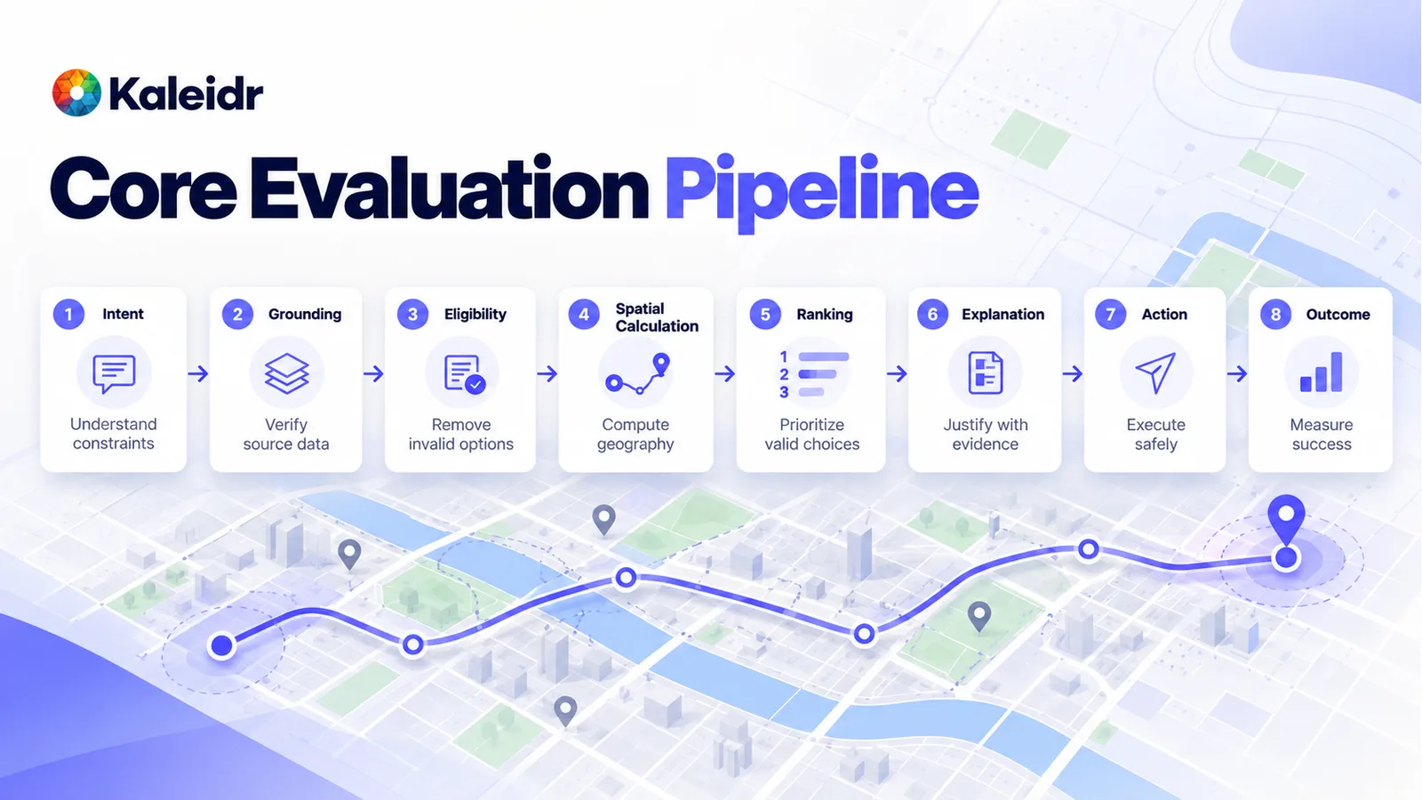
Test the chain in order: understand the constraints, verify the source, drop invalid options, compute the geography, rank what remains, justify it with evidence, act only when the action is allowed, and measure whether the job was completed.
Why Is One Score Not Enough?
An overall percentage is easy to compare and easy to misuse. An illustrative scorecard can read 92 percent overall while intent sits at 99 percent, routing at 98 percent, explanation at 96 percent, and authorization at 75 percent. Those figures are an example, not a Kaleidr result. The average still looks strong while the system might expose or act on data the person should not reach. Critical dimensions need their own production gates. Excellent performance on a low-risk task must not compensate for a permissions failure, an invalid destination, an unsupported action, or fabricated availability.
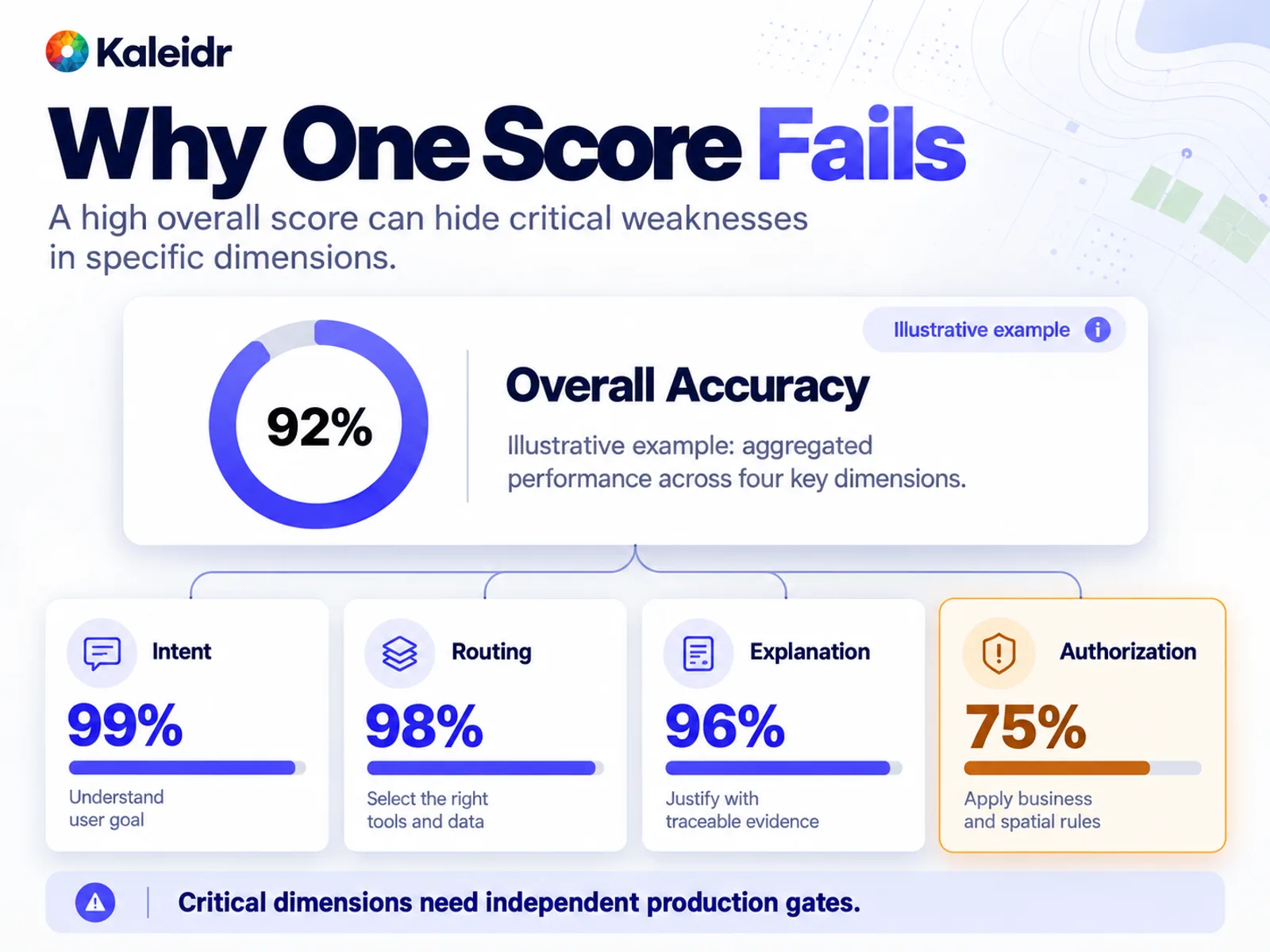
A high overall score can hide a weak gate. The percentages on this figure are an illustrative example, not measured Kaleidr performance.
NIST's AI Risk Management Framework playbook says measurement should start with the most significant risks, and that risks which will not be measured should be documented. The same playbook page notes that the AI RMF 1.0 is being updated and that the playbook will be revised afterward (NIST, 2026). NIST's initial public draft of the TEVV-Athlon framework, NIST AI 200-2, announced on August 7, 2026 with comments open through October 6, 2026, describes evaluation as evidence that a system meets individual or organizational goals, using measurement customized to those needs, including real-world impact (NIST, 2026). The document is a draft seeking input. The draft is not a Kaleidr control list. For a location-aware product, the context is the geographic decision the product actually makes.
How Should Intent, Place, and Eligibility Be Tested?
Intent comes first. A request for a wheelchair-accessible coffee shop between a hotel and a venue, open before 7 AM, is not "coffee shops near the hotel." Store the expected structured reading for each test query: category, geographic relation, origin, destination, accessibility, and time. Then measure constraint extraction, constraints the system invented, and constraints it dropped. A system that gets the category and ignores the time window has not interpreted the task.
Place language is ambiguous. Springfield, Terminal 2, Main Street, and "our Austin store" can each name more than one entity. Include duplicate cities, identical branch names, multiple terminals, renamed places, abbreviations, multilingual names, neighborhoods without a hard boundary, and addresses on an administrative border. Score canonical place identifiers, not string match on the name. The wrong coffee shop one block away and a destination in the wrong city are both incorrect, and they are not the same severity.
Eligibility asks whether a place may be considered. Ranking asks how high a valid place should sit. A branch can be the closest pin and still be closed, out of stock, outside the service area, fully booked, or forbidden by policy. Those candidates should leave the set before anyone ranks what remains. Eligibility precision is eligible returned places divided by all returned places. For a high-risk workflow, a few ineligible recommendations can matter more than average rank quality. Inventory, hours, permissions, and policy stay in the systems that own them. Grounded spatial AI for business data draws that same line for the product itself.
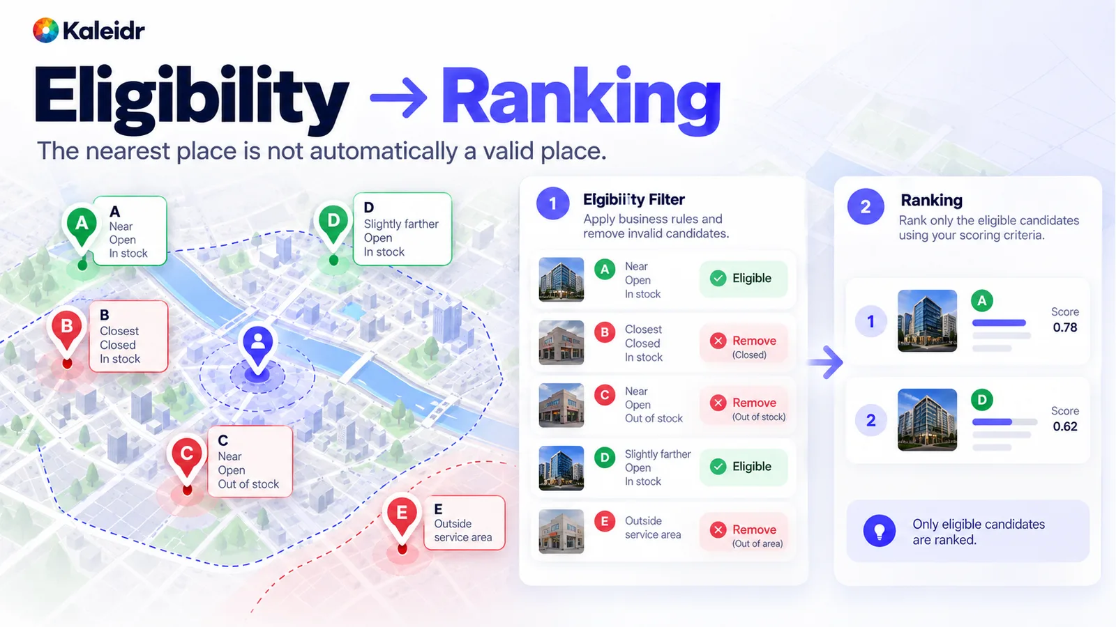
Filter eligibility first. The nearest place is not automatically a valid place.
How Should Geography and Freshness Be Checked?
A language model should not be the source of truth for a calculation a spatial engine can compute. Point-in-polygon, route distance, travel time, service-area membership, containment, and order along a route belong in that set. Build the expected answer from authoritative geographic data and a trusted tool, then compare the application's result with that answer. Exact match fits "is this point inside this polygon" and "did the system return branch ID 172." A predeclared tolerance fits coordinates, estimated travel time, and boundaries drawn at different resolutions. Do not decide after the run that an incorrect result was close enough.
Freshness is a separate question from historical correctness. Coordinates and branch identity can be stable while hours, inventory, traffic, and closures move. Track the share of decisions made on data outside the freshness threshold, and the share of time-sensitive fields that carry a known update time. Missing data is not the same fact as "unavailable." A confident yes or no built on an unknown state is a failure even when the place itself is real.
When Is No Result the Accurate Answer?
A customer can ask for a location within ten minutes that has an item after 9 PM when no such place exists. A weak system relaxes the constraint in silence and returns a branch twenty minutes away. A grounded system says that no verified option meets all of the conditions. Benchmarks should include intentionally unsatisfiable tasks, then track the correct no-result rate and the rate of false recommendations. GeoBenchX, a 2025 benchmark of tool-calling agents on multistep geospatial tasks, includes both solvable and intentionally unsolvable tasks so rejection accuracy can be measured (Krechetova and Kochedykov, 2025). That paper evaluates research agents. GeoBenchX does not score Kaleidr, and a product team should still write unsolvable cases for its own job.
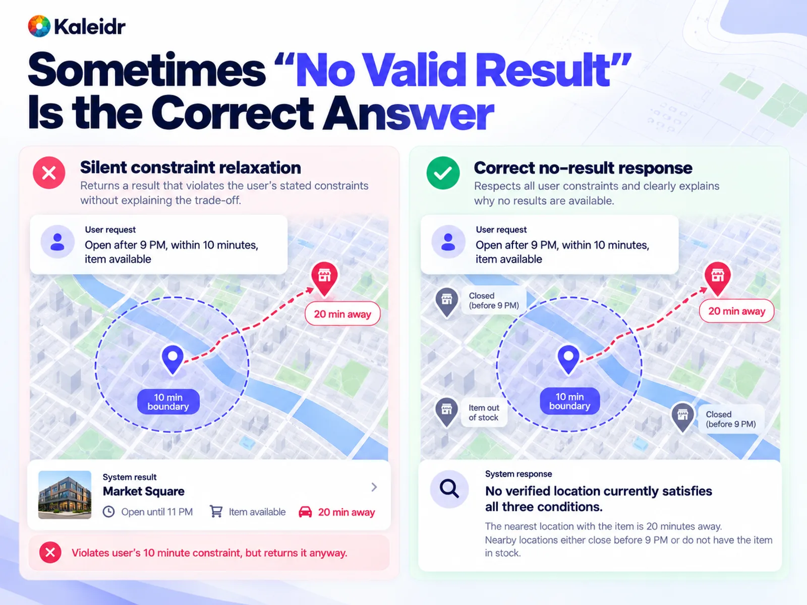
Sometimes no valid result is the correct answer. Returning a place outside the stated time or distance is a false recommendation, not a helpful fallback.
How Should Ranking, Explanation, and Actions Be Scored?
Rank only after invalid candidates are gone. Nearest is not automatically best. Travel time, route deviation, availability, accessibility, price, opening window, and business priority can all be part of the objective, if the product says so. Useful measures include how often the first result is acceptable, how often an acceptable choice appears in the first K results, agreement with a human-reviewed or policy order, and regret against the strongest known eligible option. Do not treat engagement as rank quality. Connect the order to the action the customer needed.
An explanation such as "open until 10 PM, item available, six minutes added to the route" is accurate only if each clause traces to evidence the system used. Check place identity, the availability claim, the hours, whether a route was actually computed, and whether the prose matches the ranking decision. A polished paragraph can still be wrong. A short awkward one can be right. Measure verified claims over factual claims in the explanation.
Actions are part of the answer. Moving the map, adding a marker, requesting a route, changing a filter, or starting a booking can be wrong even when the sentence is right. Track whether the action is in the application's vocabulary, whether the target and parameters are correct, and whether the person was allowed to take it. A correct sentence paired with the wrong map action is still a failed interaction.
Which Failure Cases Belong in the Benchmark?
A set made only of clean examples the team already knows how to solve will overstate reliability. Include ambiguous names, duplicate branches, addresses on a service-area edge, unsatisfiable requests, a store that just closed, inventory that does not match the place, a nearby pin that blows up the route, a closing time before arrival, a private facility the user cannot see, a local name that differs from the English name, unknown hours, a public source that disagrees with first-party data, retrieved text that tries to steer the model, and a routing or business-data service that is down. The point is to reproduce the decisions production will actually face.
Retrieved text that tries to steer the model is a prompt-injection case. OWASP describes LLM01:2025 prompt injection as user or retrieved input that changes model behavior in unintended ways, including influence over a critical decision, and notes that retrieval-augmented generation does not fully remove the weakness (OWASP, 2025). Put that case in the security family of the test set, beside permissions, rather than treating security as a later appendix.
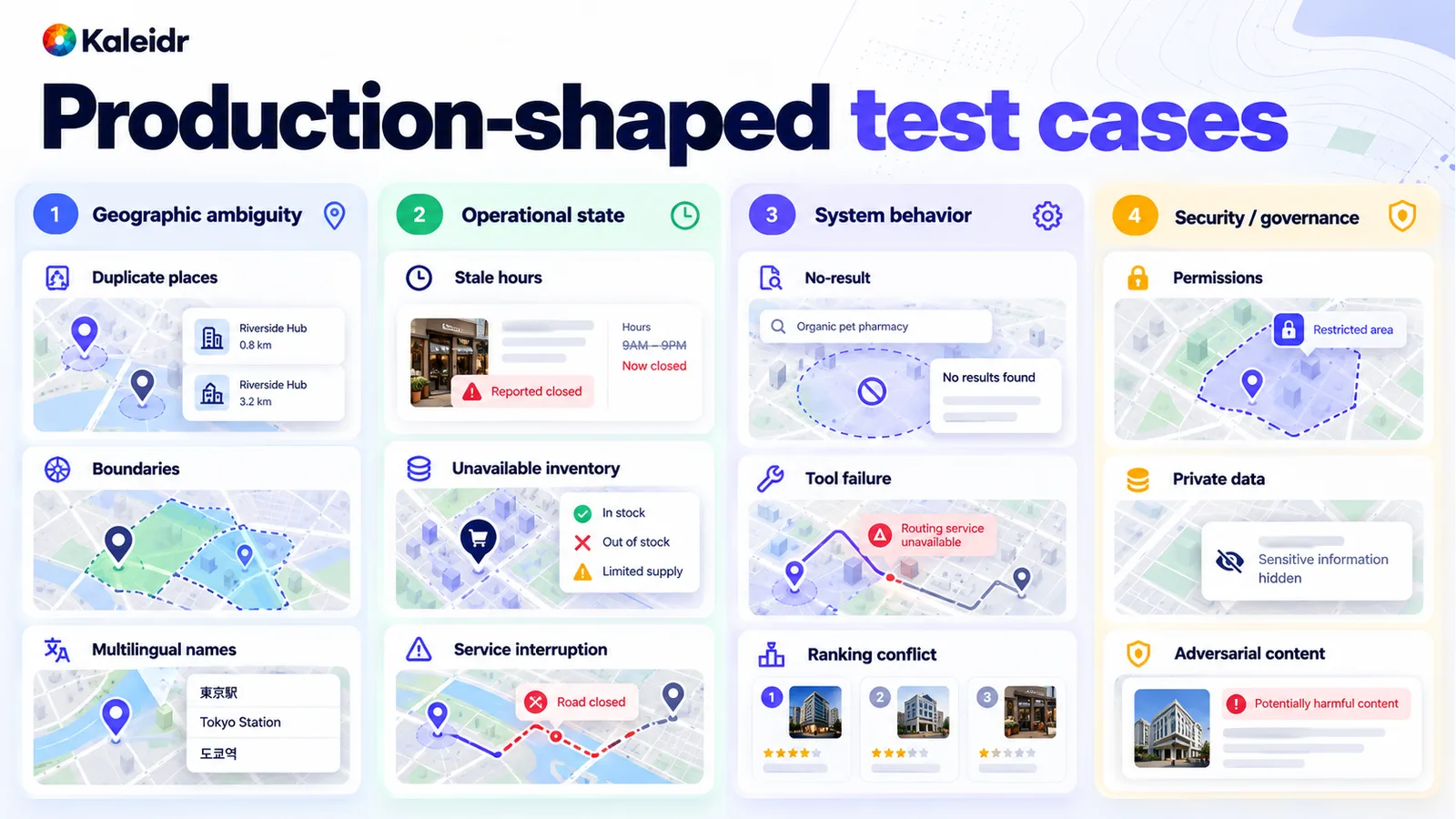
Production-shaped cases cover geographic ambiguity, operational state, system behavior, and security. A benchmark that omits them will overstate reliability.
Why Must Ground Truth Exist Before the Run?
Every case needs enough recorded truth to say what correct means: the query, the user context, the authorized sources, the expected intent, the required constraints, the canonical places, the eligible set, the expected spatial relationship, the best result, acceptable alternatives, the expected action, the reason a no-result is correct, the tolerance, and the severity if the system is wrong. Write that record before the system runs. Adapting the answer key to whatever the model produced is not an evaluation.
GISAgentBench, a 2026 practitioner-sourced benchmark of 349 multistep GIS tasks, argues that many GIS-agent benchmarks lack ground-truth outputs and instead use surrogate signals such as code similarity, trajectory matching, or a model judge, which can treat a similar workflow as a correct result. Each GISAgentBench task includes an exact ground-truth output file (Pothuri et al., 2026). Use code or an authoritative record wherever the question is deterministic: coordinates, containment, canonical ID, open or closed, permission, and which API action was called. Save human review, or a calibrated model-assisted review, for questions that are actually subjective, such as whether an explanation is understandable. The evaluator should match the kind of truth being tested.
How Should Teams Read a Segmented Result?
An average can hide a weak geography. Break results by country, market, language, urban and rural coverage, data provider, place category, branch density, query complexity, and route type. Suppose the overall valid-result rate is 95 percent and a newly launched market sits at 78 percent. That pair is a hypothetical illustration, not a Kaleidr measurement. The average can be arithmetically true and still be the wrong number to scale on. Inspect where errors occur, then assign each failed case to a category: interpretation, entity resolution, grounding, eligibility, spatial calculation, freshness, ranking, explanation, action, security, or recovery. The category tells the team what to change. A routing miss is not an explanation problem.
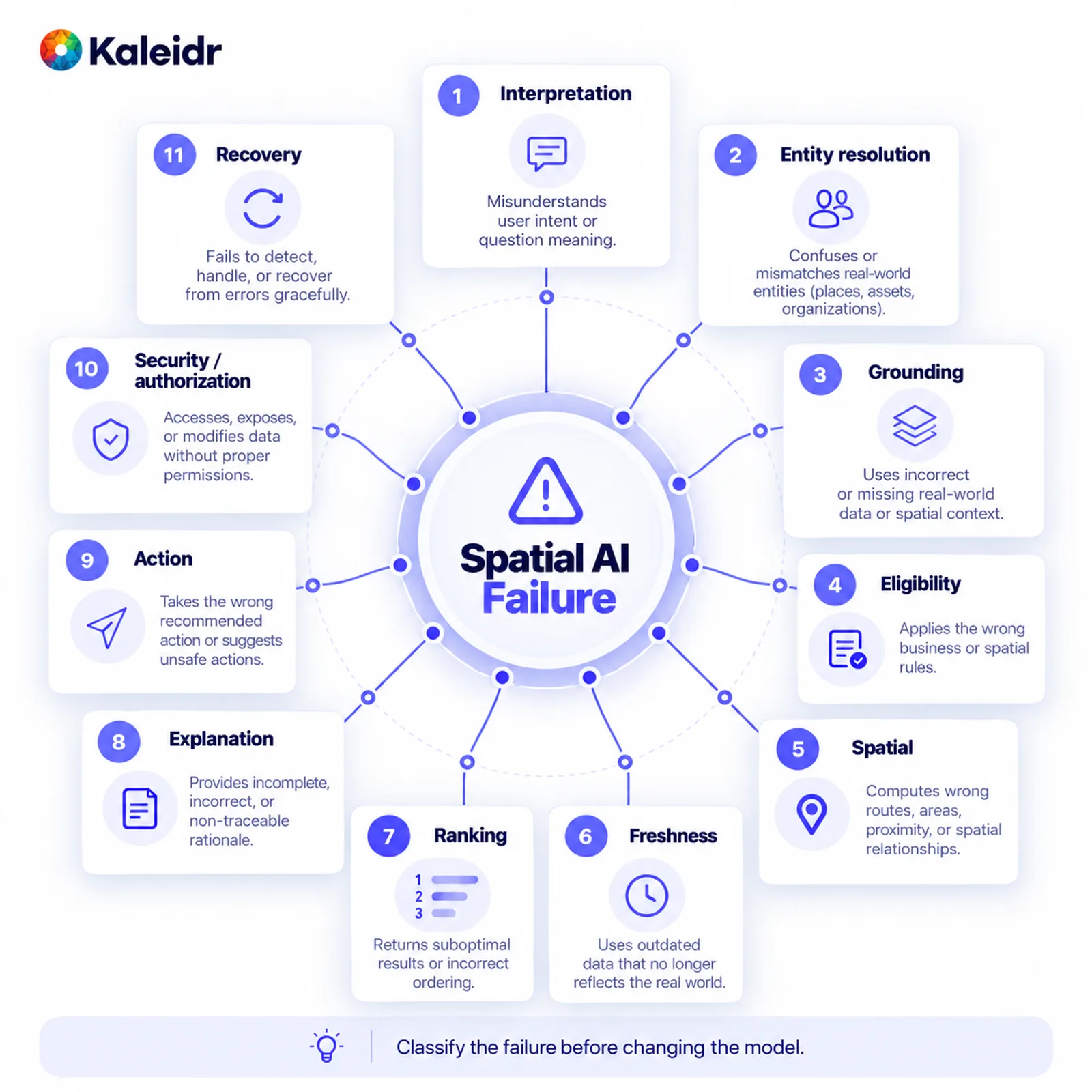
Classify the failure before changing the model. Equal categories keep a rare, severe miss from disappearing inside a large average.
Generative runs also vary. For important cases, record the average, the worst observed run, and how often the failure repeats. A query that is safe nine times and wrong once has a different risk from a query that returns the same safe answer every time. Repeat the set when prompts, models, retrieval, ranking, data providers, tools, or coverage change. Evaluation belongs in release management, not in a single pre-launch report.
What Belongs on a Production Scorecard?
Give each dimension its own metric and its own gate. Intent can use constraint extraction. Place identity can use canonical-place accuracy. Authorization and security can use an unauthorized-access rate that protected data does not tolerate. Eligibility, spatial calculation, freshness, ranking, no-result handling, explanation, actions, and outcome each need a threshold the product owner sets before the run. Do not copy a universal cutoff from another application. A casual restaurant suggestion and a routing decision with safety consequences do not share an error budget.
| Dimension | Example metric | Example gate |
|---|---|---|
| Intent | Constraint extraction accuracy | Set for this product |
| Place identity | Canonical-place accuracy | Very high |
| Authorization | Unauthorized access rate | None tolerated for protected data |
| Eligibility | Eligible-result precision | Very high |
| Spatial calculation | Correct within a predeclared tolerance | Set for this product |
| Freshness | Share of results inside the freshness window | Set for this product |
| Ranking | Top-1 or top-K acceptance | Set for this product |
| No-result handling | Correct rejection rate | High |
| Explanation | Supported-claim rate | High |
| Actions | Valid, correctly parameterized action rate | Very high |
| Outcome | Completion of the location-dependent task | Must improve the intended job |
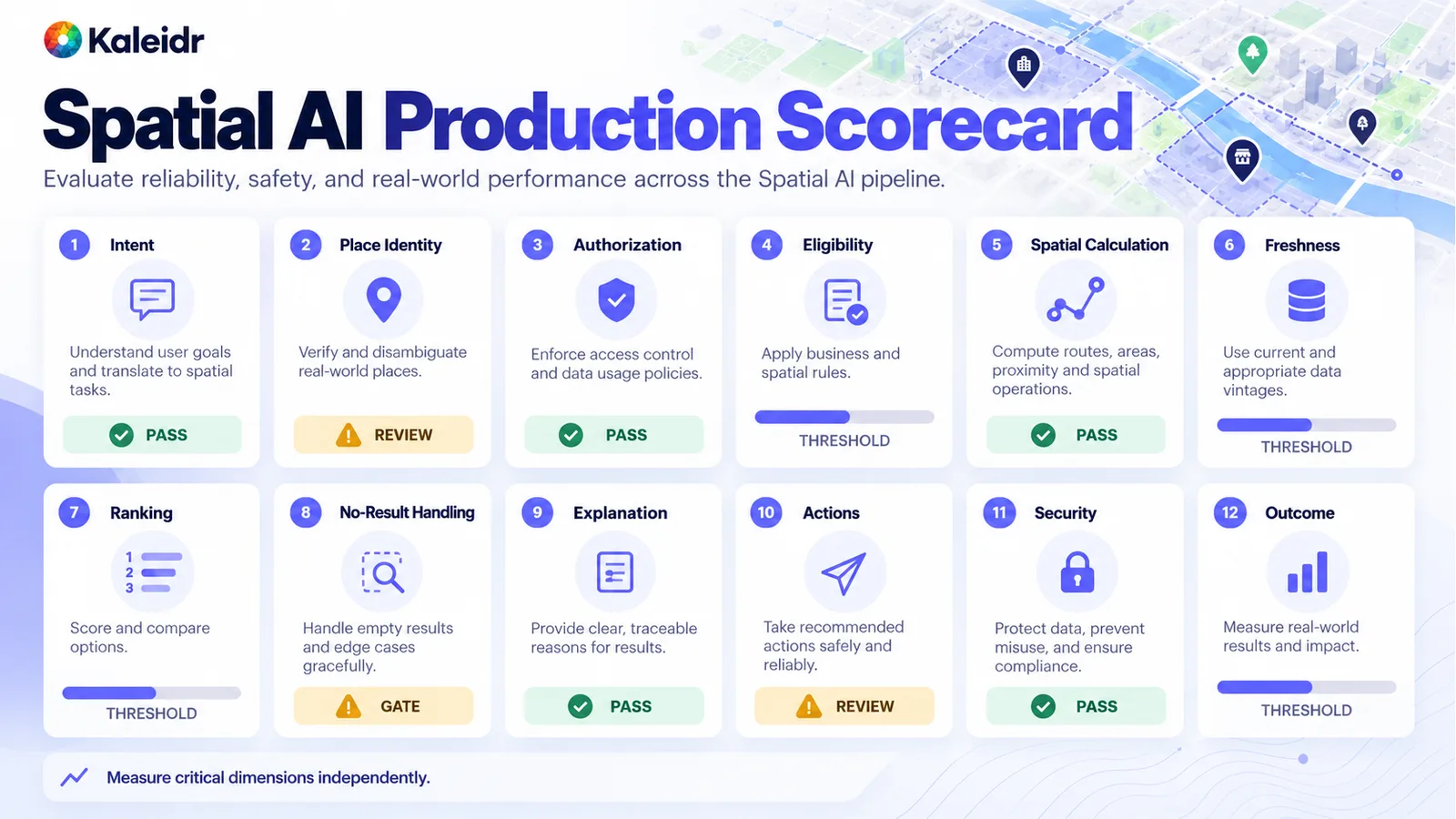
Measure critical dimensions independently. Status labels on this scorecard are placeholders, not Kaleidr benchmark scores.
How Should a Team Decide Whether to Scale?
Use the gates, not a blended score. Scale when valid, grounded, spatially correct results hold in production-shaped conditions, critical error classes are controlled, someone owns the operational data, and the intended outcome improves. Iterate when the job is valuable and a fixable layer is still weak. Narrow when the pilot mixes too many geographies, sources, or jobs to say what failed. Stop when the team cannot name authoritative data, cannot control a critical failure, cannot define the task, or cannot show an improvement over the current workflow. An enterprise Spatial AI pilot is the bounded test. The scorecard is how that test becomes a decision.
Where Does Kaleidr Fit in the Evaluation?
Kaleidr Enterprise describes location-intelligence infrastructure with inference APIs, ranking systems, analytics, and deployment support, including chat, editing, tiles, and embeddable viewers a host can add beside a map it already runs (Kaleidr, 2026). The host application keeps the business systems it owns: inventory, permissions, customer state, booking, and other private operational records. Spatial tools own calculations that can be computed. The language-model layer interprets intent, coordinates supported capabilities, and explains grounded results. Kaleidr's public Analytics page, titled Map Engagement and Location Analytics, describes reach, views, engagement, audience location and activity, sessions and interactions per map, place comparison, and spatial patterns (Kaleidr, 2026). Those reports describe map and place behavior. Completed bookings, orders, and qualified leads stay in the host systems that record them.
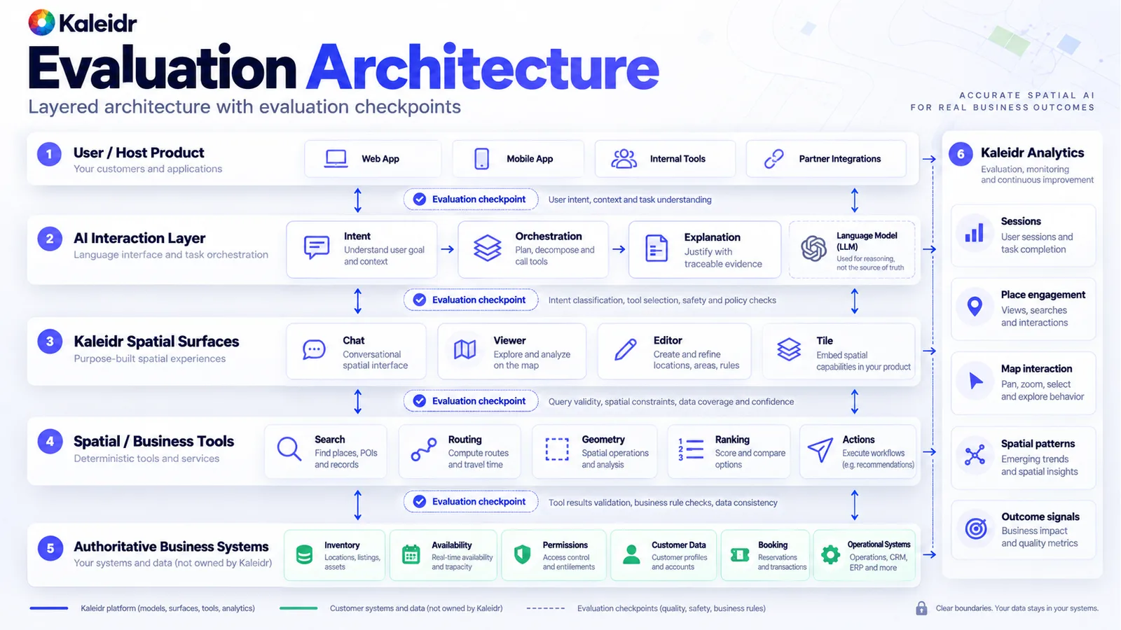
The language model is not the source of truth for inventory, permissions, or a route. Checkpoints between layers show which part failed.
Which Mistakes Hide a Weak Benchmark?
Happy-path questions, without ambiguity, missing data, or an unsatisfiable request, overstate reliability. Scoring only how similar the wording is to a reference misses a correct decision phrased differently and rewards a wrong place written in the reference's style. Ranking a set that still contains ineligible places hides the eligibility failure. Asking the model to check a distance the spatial engine can compute substitutes fluency for a calculation. Ignoring freshness treats yesterday's hours as today's. Treating more map interaction as accuracy confuses interest with success, and sometimes with confusion. Changing a tolerance after seeing the numbers is not a benchmark. Testing the model alone ignores retrieval, data, tools, permissions, ranking, and the interface. Production behavior is the assembled product.
Research benchmarks still help as capability probes. GeoBenchLLM, submitted in August 2026 and accepted at CIKM 2026, evaluates language models on geo-related tasks drawn from public datasets, including geo-spatial and temporal understanding (Rodrigues et al., 2026). GeoAI benchmarks often cover remote sensing, GIS workflows, imagery, or geospatial model tasks. A product benchmark may also need business-data grounding, permissions, live availability, ranking, map actions, and the customer outcome. One public benchmark cannot stand in for every product's job.
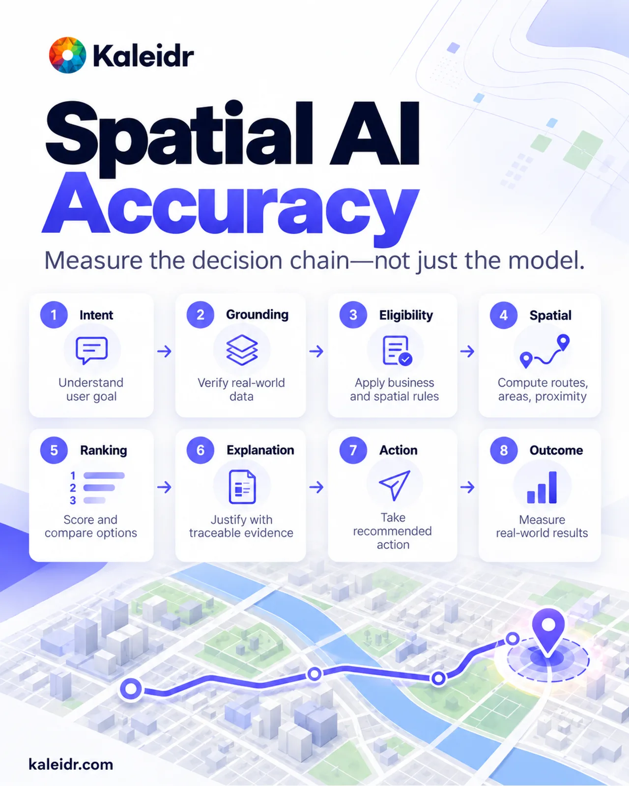
Measure the decision chain, not only the model. The eight stages are the evaluation outline, not a reported score.
How Does Evaluation Become a Release Gate?
Build the test set before scaling. Include the failure cases. Keep deterministic truth outside the language model where a tool or a record can answer. Track critical dimensions on their own gates. Repeat the run when the system changes, and connect the offline result to the production outcome the job was supposed to improve. The useful question is whether this system can make the location-dependent decision the product promises, with the right data, geography, permissions, and actions, and whether the team can prove it.
Explore Kaleidr Enterprise to add location-aware AI beside the systems a product already runs, and to define a focused pilot. Explore Kaleidr Analytics to see how audiences use the maps and places in that pilot. The host still owns the business outcome and the decision to scale.
FAQs
How do you measure spatial AI accuracy?
Measure the stages of the location decision: intent, place resolution, authorization, eligibility, geographic calculations, freshness, ranking, explanation, action, and the user or business outcome. Do not collapse that chain into one model score.
Is this the same as language-model accuracy?
No. A language model is one component. Place databases, business records, spatial engines, routing, ranking, permissions, and application state can all change whether the result is correct.
Should a language model calculate distance?
Use a geographic or routing tool when the product needs a distance or a travel relationship. The model can choose when the calculation is required and can explain the result. The spatial service performs the calculation.
Should benchmarks include impossible questions?
Yes. Intentionally unsatisfiable tasks show whether the system returns a grounded no-result response instead of inventing a place or quietly dropping a constraint.
How often should evaluation run?
Run it before production, and again when models, prompts, data providers, ranking, spatial tools, permissions, or coverage change. Watch production behavior continuously. A launch-day report is not a release process.
Can one benchmark compare every system?
Research benchmarks can compare a stated capability. Production evaluation has to reflect the geographic job, the data, the risks, the tools, and the outcome of that application. GeoAI benchmarks and product benchmarks are not interchangeable.
References
- National Institute of Standards and Technology. AI RMF Playbook, Measure. Notes that the AI RMF 1.0 is being updated and that the playbook will be revised afterward. Accessed September 29, 2026. https://airc.nist.gov/airmf-resources/playbook/measure/
- National Institute of Standards and Technology. The TEVV-Athlon Framework for Evaluating AI Systems. NIST AI 200-2, initial public draft. Announced August 7, 2026; comments through October 6, 2026. https://www.nist.gov/artificial-intelligence/ai-research/tevv-athlon-framework-evaluating-ai-systems
- Krechetova, Varvara, and Denis Kochedykov. GeoBenchX: Benchmarking LLMs in Agent Solving Multistep Geospatial Tasks. arXiv:2503.18129, submitted March 23, 2025, revised October 22, 2025. https://arxiv.org/abs/2503.18129
- Pothuri, Abhinav, Zhe Jiang, Zelin Xu, and Di Yang. GISAgentBench: A Practitioner-Sourced Benchmark for Evaluating LLM Agents on GIS Tasks. arXiv:2608.01645, submitted August 3, 2026. https://arxiv.org/abs/2608.01645
- Rodrigues, Rodrigo Ferreira, Karim Radouane, Jose G. Moreno, and Lynda Tamine. GeoBenchLLM: A Comprehensive Benchmark for Evaluating LLMs on Geo-Related Tasks. arXiv:2608.07411, submitted August 7, 2026. Accepted at CIKM 2026. https://arxiv.org/abs/2608.07411
- OWASP Gen AI Security Project. LLM01:2025 Prompt Injection. Accessed September 29, 2026. https://genai.owasp.org/llmrisk/llm01-prompt-injection/
- Kaleidr. Location Intelligence APIs and Map SDK. Accessed September 29, 2026. https://kaleidr.com/enterprise
- Kaleidr. Map Engagement and Location Analytics. Accessed September 29, 2026. https://kaleidr.com/analytics
- Kaleidr. Grounded Spatial AI for Business Data. https://kaleidr.com/blog/grounded-spatial-ai-business-data
- Kaleidr. An Enterprise Spatial AI Pilot Before Scaling. https://kaleidr.com/blog/enterprise-spatial-ai-pilot-before-scaling
@misc{nist_rmf_playbook_measure_2026,
  title  = {AI RMF Playbook, Measure},
  author = {{National Institute of Standards and Technology}},
  year   = {2026},
  note   = {Accessed September 29, 2026. Page states the playbook will be updated after the AI RMF revision},
  url    = {https://airc.nist.gov/airmf-resources/playbook/measure/}
}

@techreport{nist_ai_200_2_2026,
  title       = {The TEVV-Athlon Framework for Evaluating AI Systems},
  author      = {{National Institute of Standards and Technology}},
  institution = {National Institute of Standards and Technology},
  number      = {NIST AI 200-2},
  year        = {2026},
  note        = {Initial public draft, announced August 7, 2026},
  url         = {https://www.nist.gov/artificial-intelligence/ai-research/tevv-athlon-framework-evaluating-ai-systems}
}

@misc{krechetova_geobenchx_2025,
  title  = {GeoBenchX: Benchmarking LLMs in Agent Solving Multistep Geospatial Tasks},
  author = {Krechetova, Varvara and Kochedykov, Denis},
  year   = {2025},
  note   = {arXiv:2503.18129, revised October 22, 2025},
  url    = {https://arxiv.org/abs/2503.18129}
}

@misc{pothuri_gisagentbench_2026,
  title  = {GISAgentBench: A Practitioner-Sourced Benchmark for Evaluating LLM Agents on GIS Tasks},
  author = {Pothuri, Abhinav and Jiang, Zhe and Xu, Zelin and Yang, Di},
  year   = {2026},
  note   = {arXiv:2608.01645, submitted August 3, 2026},
  url    = {https://arxiv.org/abs/2608.01645}
}

@misc{rodrigues_geobenchllm_2026,
  title  = {GeoBenchLLM: A Comprehensive Benchmark for Evaluating LLMs on Geo-Related Tasks},
  author = {Rodrigues, Rodrigo Ferreira and Radouane, Karim and Moreno, Jose G. and Tamine, Lynda},
  year   = {2026},
  note   = {arXiv:2608.07411, submitted August 7, 2026, accepted at CIKM 2026},
  url    = {https://arxiv.org/abs/2608.07411}
}

@misc{owasp_llm01_2025,
  title  = {LLM01:2025 Prompt Injection},
  author = {{OWASP Gen AI Security Project}},
  year   = {2025},
  note   = {Accessed September 29, 2026},
  url    = {https://genai.owasp.org/llmrisk/llm01-prompt-injection/}
}

@misc{kaleidr_enterprise_accuracy_2026,
  title  = {Location Intelligence APIs and Map SDK},
  author = {{Kaleidr}},
  year   = {2026},
  note   = {Accessed September 29, 2026},
  url    = {https://kaleidr.com/enterprise}
}

@misc{kaleidr_analytics_accuracy_2026,
  title  = {Map Engagement and Location Analytics},
  author = {{Kaleidr}},
  year   = {2026},
  note   = {Accessed September 29, 2026},
  url    = {https://kaleidr.com/analytics}
}