
Spatial AI ROI is the incremental business value created when a location-aware product helps a customer or operator finish a measurable job better than the current journey, minus the full cost of that improvement. A defensible case starts with one location-dependent friction, a baseline frozen before launch, and an outcome the host system already records. Map views, searches, and assistant replies can explain the path. Those signals do not replace a counterfactual or a finance-approved unit value.
The sections below separate the job, the value tree, the metric ladder, the counterfactual, the cost denominator, and the scale gate. Related reading includes An Enterprise Spatial AI Pilot, Spatial Analytics vs. Web Analytics, and Grounded Spatial AI for Business Data. A pilot proves one bounded workflow. A business case says whether that evidence deserves the next investment.
Spatial AI ROI essentials
- Name one job: A location-dependent decision the business already cares about.
- Freeze the baseline: Same outcome definition before and after launch.
- Keep the counterfactual: Ask what would have happened without the new experience.
- Monetize the outcome: Leading signals explain the move. The host record carries the value.
- Gate the scale decision: Value, quality, operating readiness, and production economics, decided in advance.
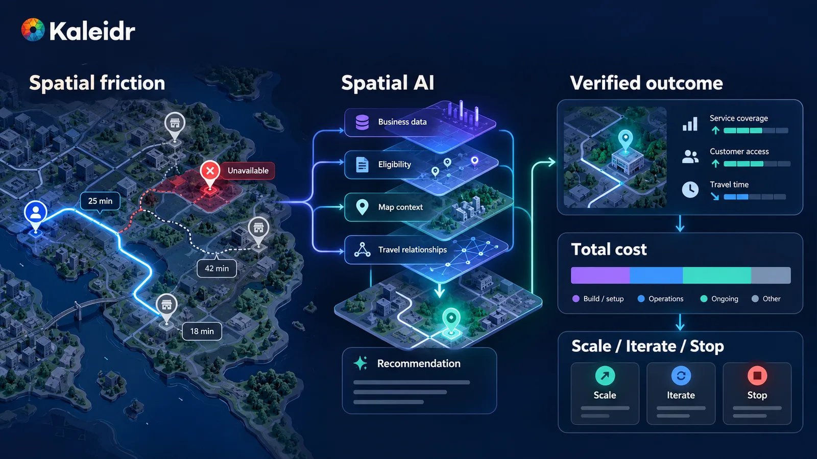
Spatial AI ROI becomes measurable when a location-dependent problem connects to an authoritative outcome, a full cost model, and a predefined scale decision. The figure is a framework. Comparison bars in the layout are not a reported lift.
Why Is Spatial AI ROI a Measurement Problem?
The arithmetic is short. Attribution is the work. A team can write the ratio only after it can name the job that changed, the system that records the outcome, the comparison that stands in for the missing counterfactual, and the costs that belong in the denominator. A map can draw more interaction because the picture is more interesting. An assistant can lengthen a session because the person had to ask again. A recommendation can raise clicks and lower qualified bookings. None of those movements is a return until an authoritative record moves with them.
ROI = (attributable benefit - total cost) / total cost
A practical chain runs from the baseline journey, through the location-dependent friction and the Spatial AI intervention, to a leading product signal, an authoritative outcome, a unit value, incremental value, total cost, and then a decision to scale, iterate, narrow, or stop. An enterprise Spatial AI pilot covers how to run a production-shaped first test. The measurement around that test is what turns the readout into a finance-ready case.
What Job Should the Case Start From?
The strongest cases begin with a sentence a business owner can read without a tour of models, embeddings, or map SDKs. Help more shoppers find an in-stock store they can realistically reach. Help guests resolve a nearby question without calling the desk. Help marketplace users find a provider who can actually serve the request. Help a dispatcher locate an eligible asset without cross-referencing three tools. Those are business jobs. The Spatial AI intervention comes after the job is named.
| Business job | Current friction | Spatial AI intervention | Authoritative outcome |
|---|---|---|---|
| Store discovery | A nearby result is out of stock | Interpret intent, filter inventory, compare travel | Pickup started or purchase completed |
| Guest assistance | Staff repeat the same location answers | Grounded map conversation on approved records | Question resolved, or a contact avoided if that avoidance is measured |
| Marketplace matching | Radius search returns providers who cannot serve | Apply service area, availability, travel, and eligibility | Qualified lead or booking |
| Fleet operations | Dispatcher cross-references maps and vehicle state | Query eligible assets with current map context | Dispatch decision completed |
| Network planning | Demand sits outside current coverage | Compare first-party demand with network coverage | Candidate market sent to formal diligence |
The outcome should come from the system that owns it. Booking systems own bookings. Commerce systems own purchases. CRM systems own qualified leads. Dispatch systems own assignments. Finance systems own realized revenue and cost. Spatial AI can influence those outcomes. The product should not invent them.
How Should a Value Tree Organize the Benefits?
Most of the value falls into four branches: revenue, cost, speed, and risk or quality. A fifth branch, learning, can matter strategically and should not be assigned a dollar amount just because a dashboard surfaced a pattern. Revenue shows up when a location-dependent decision already sits on a commercial path, such as an eligible store selection that becomes a host transaction through a stable identifier. Cost shows up when a measurable manual task disappears, and only if the organization can say what happens to the recovered time. A saved minute is capacity until someone can show a reduced expense or added throughput.
Speed can be valuable before revenue attribution is stable: time to a useful place, time to an eligible service location, time to investigate a candidate market. Risk and quality show up as fewer recommendations for closed or ineligible locations, fewer inventory claims that fail on revalidation, and fewer operator decisions made on stale context. Use a financial value for an avoided failure only where the business already has a defensible unit cost. Otherwise keep the risk as a guardrail.
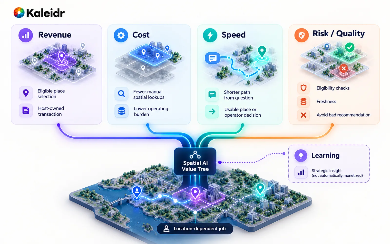
Spatial AI can create value through revenue, cost, speed, or risk reduction. Learning can be strategically useful without a speculative financial value.
Which Signals Climb Toward Economic Value?
A case is easier to audit when metrics sit on a ladder instead of in one dashboard as equals. Exposure asks whether the person had a real chance to use the experience. Activation asks whether the person searched, filtered, opened a place, or requested a route. Useful resolution asks whether the system returned an eligible, grounded, or successfully routed result. Selection asks whether the person moved toward a decision. The authoritative action is the handoff into the system of record: a reservation start, a lead, a checkout, a dispatch. The verified outcome is the result that system records. Economic value is what that incremental outcome is worth after variable cost.
Exposure → Activation → Useful resolution → Selection
        → Business action → Verified outcome → Economic value
The ladder stops a common substitution: treating a leading indicator as realized value. Spatial analytics versus web analytics separates the questions those layers answer. Web analytics can say whether people reached the experience. Spatial analytics can say whether geography changed success. The booking, order, or qualified lead still belongs to the host system of record, and finance still applies contribution only to the incremental completed outcome.
How Do Product Signals Differ From Business Outcomes?
Spatial metrics organize places, travel relationships, service areas, routes, and coverage. That organization does not replace business analytics. Kaleidr's public Analytics page, titled Map Engagement and Location Analytics, describes reach, views, and engagement dashboards, audience location and activity, sessions, views, and interactions per map, place comparison, spatial patterns, and AI-powered spatial trends that product, inventory, and growth teams can read as map behavior (Kaleidr, 2026). Those reports explain how audiences discover and use places. Completed purchases, bookings, qualified leads, dispatches, and realized revenue stay in the host systems that own those records.
A restaurant-discovery example shows the join without pretending one dashboard owns it. Product signals may show that assisted sessions select a restaurant more often. Spatial analysis may show that the change is strongest when the diner is far from the initial map center. The reservation platform shows whether those selections became bookings. Finance applies contribution only to the incremental completed bookings. Connect the layers. Do not force one system to answer every question.
What Counterfactual Makes the Lift Incremental?
The central question is not whether conversion rose. The question is what conversion would have been, for the same eligible population in the same period, without the intervention. A randomized user-level experiment is usually the cleanest design for a customer-facing product, because seasonality, marketing, pricing, and supply hit both groups. When the experience changes a whole location, a market holdout of comparable branches or service territories can stand in, with the caveat that market size, competition, supply, and travel behavior still differ. A staggered rollout creates temporary comparison windows when every market will eventually receive the product. A pre/post comparison is usable when no control exists, and it should be labeled weaker causal evidence than a randomized experiment.
NIST's initial public draft of the TEVV-Athlon framework, NIST AI 200-2, announced on 7 August 2026 with comments open through 6 October 2026, describes test, evaluation, verification, and validation as evidence that an AI system meets individual or organizational goals, using measurement customized to those needs, including real-world impact and outcomes (NIST, 2026). The document is a draft seeking input. The draft is not a Kaleidr control list, and a model benchmark still does not prove that a customer found the right branch or that a business action improved. Freeze the outcome definition, the eligible population, and the comparison method before anyone reads the result.
Where Does Geography Change the Readout?
An average lift can hide a spatial failure. Dense markets may improve while low-supply regions get worse, and no-result rates may spike near a service-area boundary. A single global average can then push a rollout into places where the system is not ready. Segment on variables that can change the location decision: market, travel-time band, supply density, eligible-result count, service-area status, inventory, device, journey type, and data freshness. Predefine those cuts. Preserve denominators. Treat small cells cautiously, and do not celebrate whichever slice looks best after the fact.
The case should also say why geography matters. If a plain search box solves the task equally well, a location-aware product may not be the right spend. Stronger cases contain a relationship that changes the answer: an in-stock store farther away can beat a closer store that is empty; a provider can serve one address and not the equally nearby address outside the service area; a stop with a short detour can beat a closer stop that adds a long delay. Location intelligence for site selection is a different value chain from a store locator. Do not borrow one workflow's conversion logic for the other.
How Should Cost Enter the Case?
The vendor invoice is not total cost. A credible denominator includes platform and usage fees, implementation, ongoing engineering and operations, governance and evaluation, and the cost of later change as markets, data domains, and business rules expand. Build versus buy for Spatial AI treats that split as an ownership decision: an internal stack can show a low vendor fee and a high operating burden, and a platform can show a visible fee and less engineering ownership. Compare operating models over a defined period. Do not treat the internal build as free because no invoice arrived.
Kaleidr's Pricing page meters AI usage in credits and map usage in map loads, and it describes Enterprise as the plan for custom usage, support, and deployment terms (Kaleidr, 2026). Those public meters can inform a deployment sketch. Actual enterprise economics should use the contract and the architecture for the specific implementation, including data, evaluation, support, and any licensed imagery that sits outside the basemap allowance. Translate lift with unit economics the finance team already accepts: incremental outcomes times value per outcome, minus incremental variable cost. For a productivity case, multiply time saved by loaded labor cost and by a realizable utilization factor. If the hours are not reduced, reassigned, or turned into throughput, the company created capacity, not a cash saving.
NIST's Generative Artificial Intelligence Profile, NIST AI 600-1, published 26 July 2024, calls for post-deployment monitoring plans that keep evaluating a generative AI system after launch, including user input, incident response, and change management (NIST, 2024). The profile is a voluntary companion to the AI Risk Management Framework. The profile is not a Kaleidr score, and it does not price any vendor. The business case should still reserve operating capacity for evaluation after launch, because business data, providers, and customer behavior keep moving. Count failure cost too, such as rework after a bad recommendation, but only where frequency and unit cost are already credible. Otherwise leave the risk as a qualitative guardrail.
Avoid double counting. Faster time to a result, more place selections, more booking starts, and more completed bookings can be one causal chain. If the completed booking already carries the financial value, do not also book revenue for the faster result and the selection. Use leading indicators to explain why the outcome moved. Monetize the final outcome unless a separate benefit is genuinely independent.
Where Does Kaleidr Fit in the Measurement Stack?
The public site groups the offer as Kaleidr AI, Studio, Analytics, and Enterprise. Kaleidr Enterprise describes location-intelligence infrastructure with inference APIs, ranking systems, analytics, and deployment support for spatial products a host can add beside systems it already runs (Kaleidr, 2026). Analytics, cited above, covers the map- and place-behavior layer. The host still connects commerce, booking, CRM, dispatch, or finance. The practical question is whether the journey can be instrumented without replacing the systems that own the facts.
Stable identifiers make that join possible. A session can recommend a location_id, the person can select that same identifier, and the order system can record a completed pickup for it. That chain is more useful than a marker click with no shared key. Grounded spatial AI for business data explains why canonical location identity belongs in the product. The same identity belongs in the ROI measurement. The goal is not to copy every business record into an analytics product. The goal is enough stable keys to connect the journey to the authoritative outcome under the organization's privacy and retention rules.
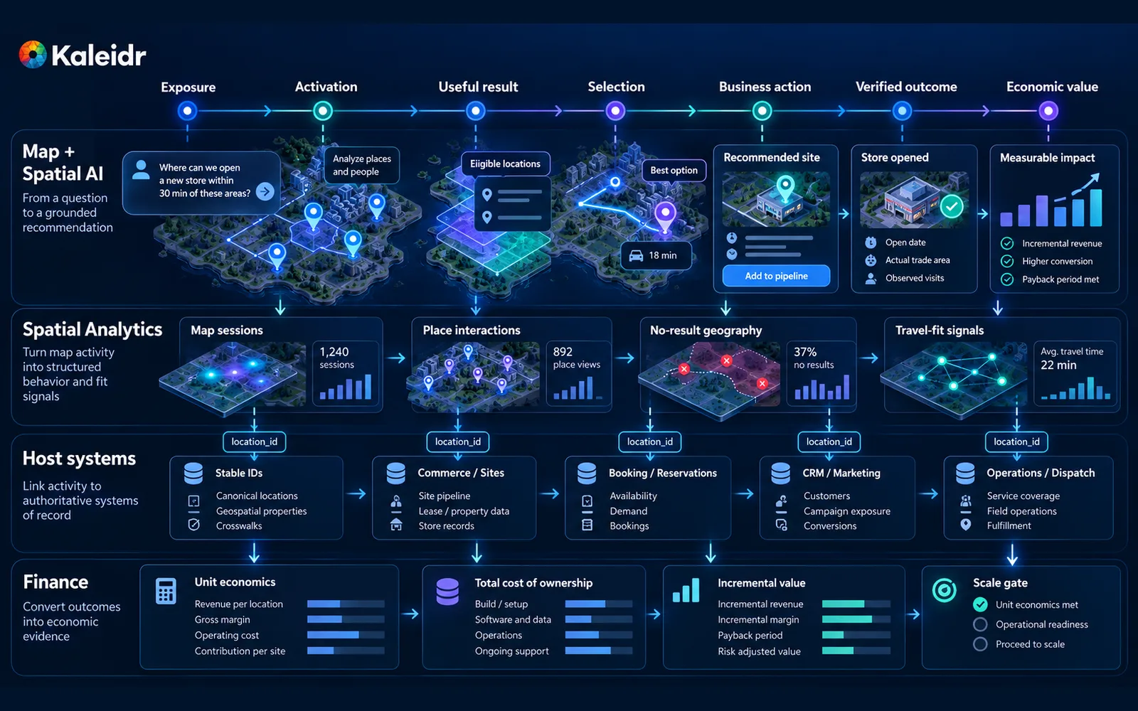
A defensible business case connects map behavior to host-owned outcomes and finance-approved economics through stable identifiers. Counts and percentages drawn on this diagram are illustrative labels, not measured Kaleidr results.
How Should a Pilot Become a Scale Gate?
Define the decision rule before the results are known. Business value asks whether the primary outcome improved enough to matter. Quality asks whether error, freshness, latency, and eligibility stayed inside agreed thresholds. Operating readiness asks whether the organization can support the data, governance, monitoring, and incident surface. Scaling economics asks whether unit value still holds when usage, markets, data volume, and support grow. A pilot that meets a quality bar has not yet proved a positive return. An apparent lift is unsafe to scale if failure rates are unacceptable. Build downside, base, and upside cases from the pilot's own ranges, and do not turn uncertainty into a single precise-looking percentage.
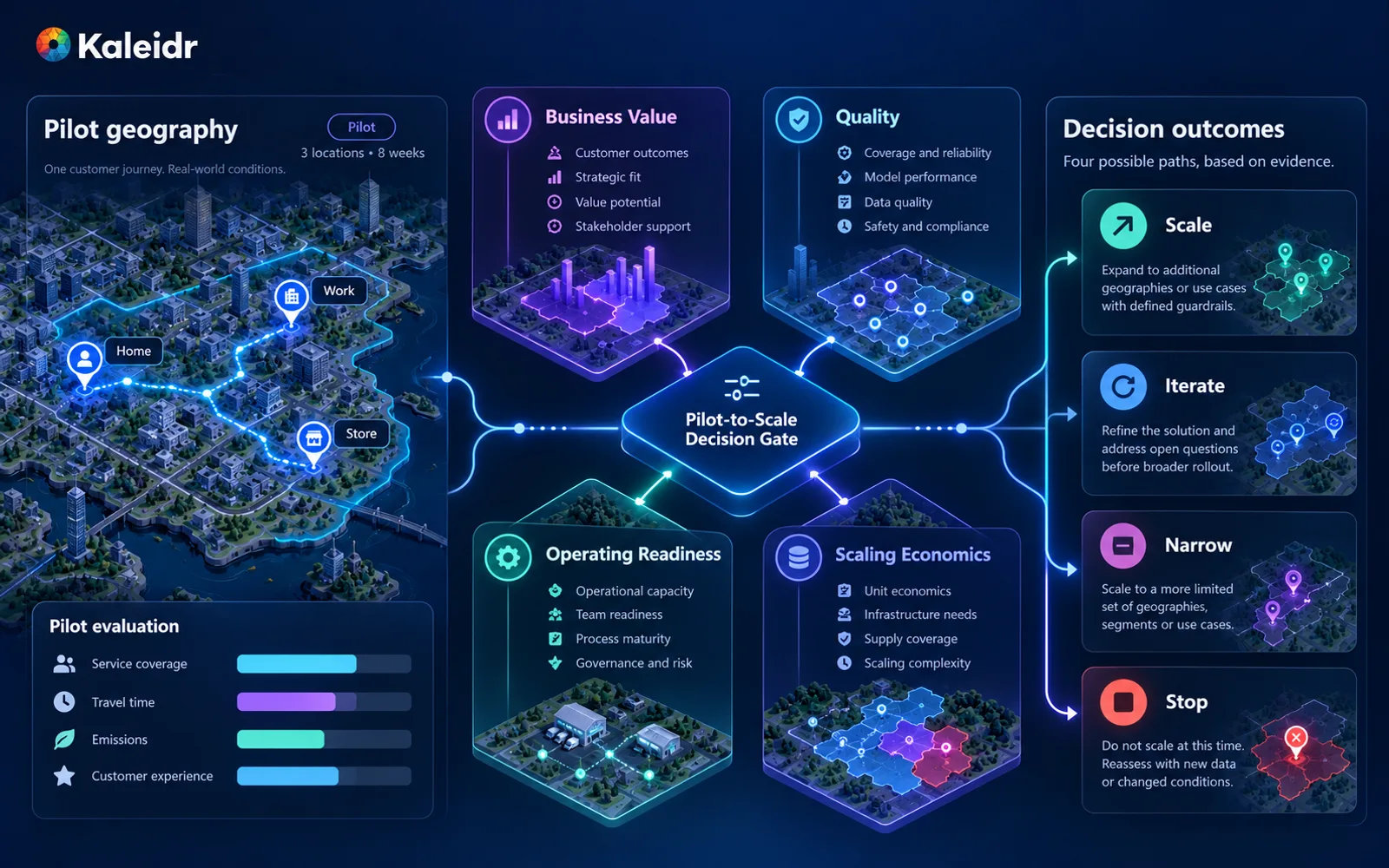
A production-shaped pilot should end with a predefined decision gate. Scale, iterate, narrow, and stop are alternative next states, not a promise that scale wins.
Explore Kaleidr Enterprise to see location-intelligence infrastructure, inference APIs, ranking, analytics, and deployment support beside the systems the company already runs. Explore Kaleidr Analytics to see map- and place-centered reporting for the behavior layer of the case. The host still owns the business outcome, the unit economics, and the decision to scale.
FAQs
What is spatial AI ROI?
Spatial AI ROI is the financial return from a location-aware product over a defined period. A defensible calculation uses attributable business benefits, subtracts the full cost of platform, data, integration, engineering, operations, evaluation, and governance, and does not treat map activity as the return.
How do you calculate it?
Use attributable benefits minus total costs, divided by total costs, for a stated period. The hard part is incrementality: what outcome changed because of the location-aware experience, compared with what would have happened without it.
Are map views a good ROI metric?
Map views are an exposure signal. Connect views to purposeful interaction, a useful result, a selection, a host-owned business action, and a verified outcome before anyone calls the activity a return.
Should faster task completion be monetized?
Only when the business can explain how the time creates economic value. Reduced task time may create capacity or allow more throughput. The time is not a cash saving unless labor or another resource actually changes.
Can Kaleidr Analytics measure the whole return automatically?
The public Analytics page documents map- and place-centered metrics such as sessions, views, interactions, audience activity, place comparison, and spatial trends. Purchases, bookings, qualified leads, dispatches, and realized revenue remain in the host systems that own those records.
How does this differ from location intelligence ROI?
The financial frame is similar. A location-aware product adds questions about intent interpretation, grounding, tool use, map actions, and evaluation. Measure the whole system, not the language model alone.
References
- Kaleidr. Map Engagement and Location Analytics. Accessed 27 September 2026. https://kaleidr.com/analytics
- Kaleidr. Pricing & Plans. Accessed 27 September 2026. https://kaleidr.com/pricing
- Kaleidr. Location Intelligence APIs and Map SDK. Accessed 27 September 2026. https://kaleidr.com/enterprise
- National Institute of Standards and Technology. The TEVV-Athlon Framework for Evaluating AI Systems. NIST AI 200-2, initial public draft. Announced 7 August 2026; comments through 6 October 2026. https://www.nist.gov/artificial-intelligence/ai-research/tevv-athlon-framework-evaluating-ai-systems
- National Institute of Standards and Technology. Artificial Intelligence Risk Management Framework: Generative Artificial Intelligence Profile. NIST AI 600-1. Published 26 July 2024. https://nvlpubs.nist.gov/nistpubs/ai/nist.ai.600-1.pdf
- Kaleidr. An Enterprise Spatial AI Pilot Before Scaling. https://kaleidr.com/blog/enterprise-spatial-ai-pilot-before-scaling
- Kaleidr. Spatial Analytics vs. Web Analytics. https://kaleidr.com/blog/spatial-analytics-vs-web-analytics
- Kaleidr. Grounded Spatial AI for Business Data. https://kaleidr.com/blog/grounded-spatial-ai-business-data
- Kaleidr. Location Intelligence for Site Selection. https://kaleidr.com/blog/location-intelligence-for-site-selection
- Kaleidr. Build vs Buy Spatial AI. https://kaleidr.com/blog/build-vs-buy-spatial-ai
@misc{kaleidr_analytics_roi_2026,
  title  = {Map Engagement and Location Analytics},
  author = {{Kaleidr}},
  year   = {2026},
  note   = {Accessed 27 September 2026},
  url    = {https://kaleidr.com/analytics}
}

@misc{kaleidr_pricing_roi_2026,
  title  = {Pricing \& Plans},
  author = {{Kaleidr}},
  year   = {2026},
  note   = {Accessed 27 September 2026},
  url    = {https://kaleidr.com/pricing}
}

@misc{kaleidr_enterprise_roi_2026,
  title  = {Location Intelligence APIs and Map SDK},
  author = {{Kaleidr}},
  year   = {2026},
  note   = {Accessed 27 September 2026},
  url    = {https://kaleidr.com/enterprise}
}

@techreport{nist_ai_200_2_2026,
  title       = {The TEVV-Athlon Framework for Evaluating AI Systems},
  author      = {{National Institute of Standards and Technology}},
  institution = {National Institute of Standards and Technology},
  number      = {NIST AI 200-2},
  year        = {2026},
  note        = {Initial public draft, announced 7 August 2026},
  url         = {https://www.nist.gov/artificial-intelligence/ai-research/tevv-athlon-framework-evaluating-ai-systems}
}

@techreport{nist_ai_600_1_2024,
  title       = {Artificial Intelligence Risk Management Framework: Generative Artificial Intelligence Profile},
  author      = {{National Institute of Standards and Technology}},
  institution = {National Institute of Standards and Technology},
  number      = {NIST AI 600-1},
  year        = {2024},
  month       = jul,
  url         = {https://nvlpubs.nist.gov/nistpubs/ai/nist.ai.600-1.pdf}
}

@misc{kaleidr_pilot_roi_2026,
  title  = {An Enterprise Spatial AI Pilot Before Scaling},
  author = {{Kaleidr}},
  year   = {2026},
  url    = {https://kaleidr.com/blog/enterprise-spatial-ai-pilot-before-scaling}
}

@misc{kaleidr_spatial_vs_web_roi_2026,
  title  = {Spatial Analytics vs. Web Analytics},
  author = {{Kaleidr}},
  year   = {2026},
  url    = {https://kaleidr.com/blog/spatial-analytics-vs-web-analytics}
}

@misc{kaleidr_grounded_roi_2026,
  title  = {Grounded Spatial AI for Business Data},
  author = {{Kaleidr}},
  year   = {2026},
  url    = {https://kaleidr.com/blog/grounded-spatial-ai-business-data}
}

@misc{kaleidr_site_selection_roi_2026,
  title  = {Location Intelligence for Site Selection},
  author = {{Kaleidr}},
  year   = {2026},
  url    = {https://kaleidr.com/blog/location-intelligence-for-site-selection}
}

@misc{kaleidr_build_vs_buy_roi_2026,
  title  = {Build vs Buy Spatial AI},
  author = {{Kaleidr}},
  year   = {2026},
  url    = {https://kaleidr.com/blog/build-vs-buy-spatial-ai}
}