
An enterprise Spatial AI pilot should prove one location-dependent customer or operational outcome before the organization scales conversational Spatial AI across every map, market, and workflow. The strongest first window is one customer job, one approved data domain, one bounded geography, and one measurable action. Business systems remain authoritative for inventory, permissions, prices, schedules, and transactions; geospatial services calculate geographic relationships; the language model interprets intent and explains grounded results on the map.
The sections below separate a demo from a production-shaped pilot, then cover scope, proof, Kaleidr's attach model, evaluation gates, and expansion. Related reading includes Grounded Spatial AI for Business Data, Spatial AI for Multi-Location Businesses, How to Build a Map-Aware AI Assistant, and Private Location Data for AI Map Workflows. The rest of the article is written for product, platform, and operations teams that already own a map or customer application, not for teams shopping for a replacement inventory, CRM, or scheduling system.
Enterprise Spatial AI pilot essentials
- One job first: A company-wide assistant is an expansion target, not a first window.
- Owners stay split: Inventory, permissions, prices, and appointments do not share one system of record with the map.
- Ground then explain: The language model is not the business database.
- Prove then scale: A slide-deck demo is not a production-shaped pilot.
- Measure the task: Usable destination, route opened, and action started beat conversation volume.
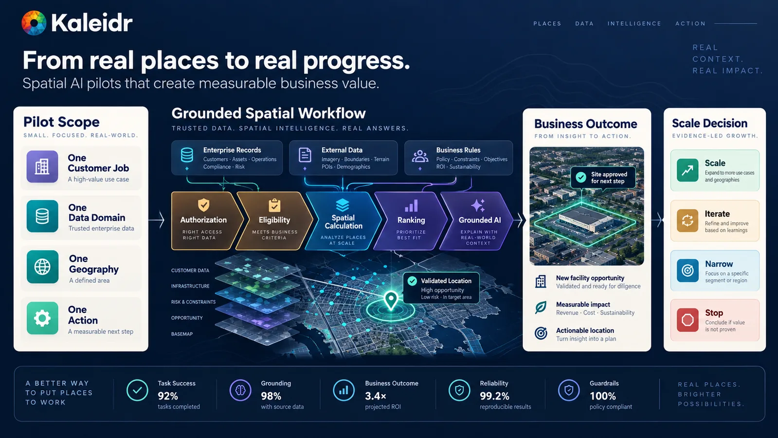
A Spatial AI pilot should prove one grounded outcome before the organization expands it.
Why Does an Enterprise Spatial AI Pilot Come First?
A generic map assistant can list nearby pins. An enterprise product has to answer which place a customer or operator can actually use given authorization, inventory, hours, service area, travel time, and the next business action. Those answers depend on canonical location identity, current operational state, and host-owned workflows. A language model should not invent those fields from training memory.
The failure mode is familiar: a polished conversation over a map that cannot complete a real task. The assistant names a closed branch, an unauthorized location, or a place outside the service area. Operators then treat Spatial AI as a demo rather than as infrastructure. Kaleidr currently closes its enterprise call to action with a narrower sequence: start with a pilot, then scale when the organization is ready (Kaleidr, 2026). That homepage line is a product posture, not a claim that every conversational map is ready for company-wide rollout.
Consequently, the first window should be small enough to instrument and large enough to matter. A useful first job is one a customer or operator already tries to complete: find an eligible service location, compare nearby branches that can fulfill a request, or start an appointment at a place the company can actually serve. Spatial AI for Multi-Location Businesses covers the catalog and eligibility side of that job. Grounded Spatial AI for Business Data covers the same boundary for authorized inventory: the model explains grounded records; the model does not become the system of record.
NIST's Artificial Intelligence Risk Management Framework (AI RMF 1.0) is a voluntary, use-case-agnostic resource for organizations designing, developing, deploying, or using AI systems to manage AI risk (NIST, 2023). A Spatial AI pilot is one way to operationalize that idea in a bounded geography: measure whether the system produces a usable, authorized, spatially correct result before the organization copies it into every channel. The framework does not prescribe a Kaleidr architecture.
How Should Teams Scope an Enterprise Spatial AI Pilot?
Scope the first window on four axes at once: one customer or operator job, one approved data domain, one geography, and one action the host application can complete. A job such as "find the right service location and request an appointment" is testable. A domain such as public location records plus availability is inspectable. A single metro or service area is geographically bounded. An action such as request appointment, get directions, or open a booking page is observable. Expanding any axis before the first window works multiplies failure modes instead of proving value.
Keep source ownership inspectable. A location directory can own place identity and coordinates. An availability or hours source can own open state. An authorization source can own which locations a user or tenant may see. A scheduling or commerce system can own the appointment or checkout. Geospatial services calculate service-area containment, travel time, and on-the-way relationships. The AI map assistant interprets the request, explains the grounded shortlist, and proposes a map action. The application layer validates each action. Permissions stay in the application and infrastructure; the language model never grants access.
By contrast, a company-wide assistant that can "answer anything about our locations" is several products at once. The request mixes catalog search, eligibility, routing, policy, and a downstream workflow. Each of those surfaces can fail independently. How to Build a Map-Aware AI Assistant treats selected place, viewport, and active filters as load-bearing context rather than decorative chat memory. A first pilot should reuse that map context for one job rather than asking the model to reconstruct the enterprise from prose.
The following comparison is editorial, not a documented Kaleidr schema. Real deployments should fill the same columns from the maps and operational feeds the host already publishes.
| Stage | What it proves | What it does not prove |
|---|---|---|
| Demo | The map can talk | Data, eligibility, and action quality |
| Prototype | One happy-path query can complete | Failure cases, authorization, and measurement |
| Pilot | One production-shaped job works in one geography | Company-wide rollout |
| Rollout | Additional jobs, datasets, markets, or channels | A second map stack |
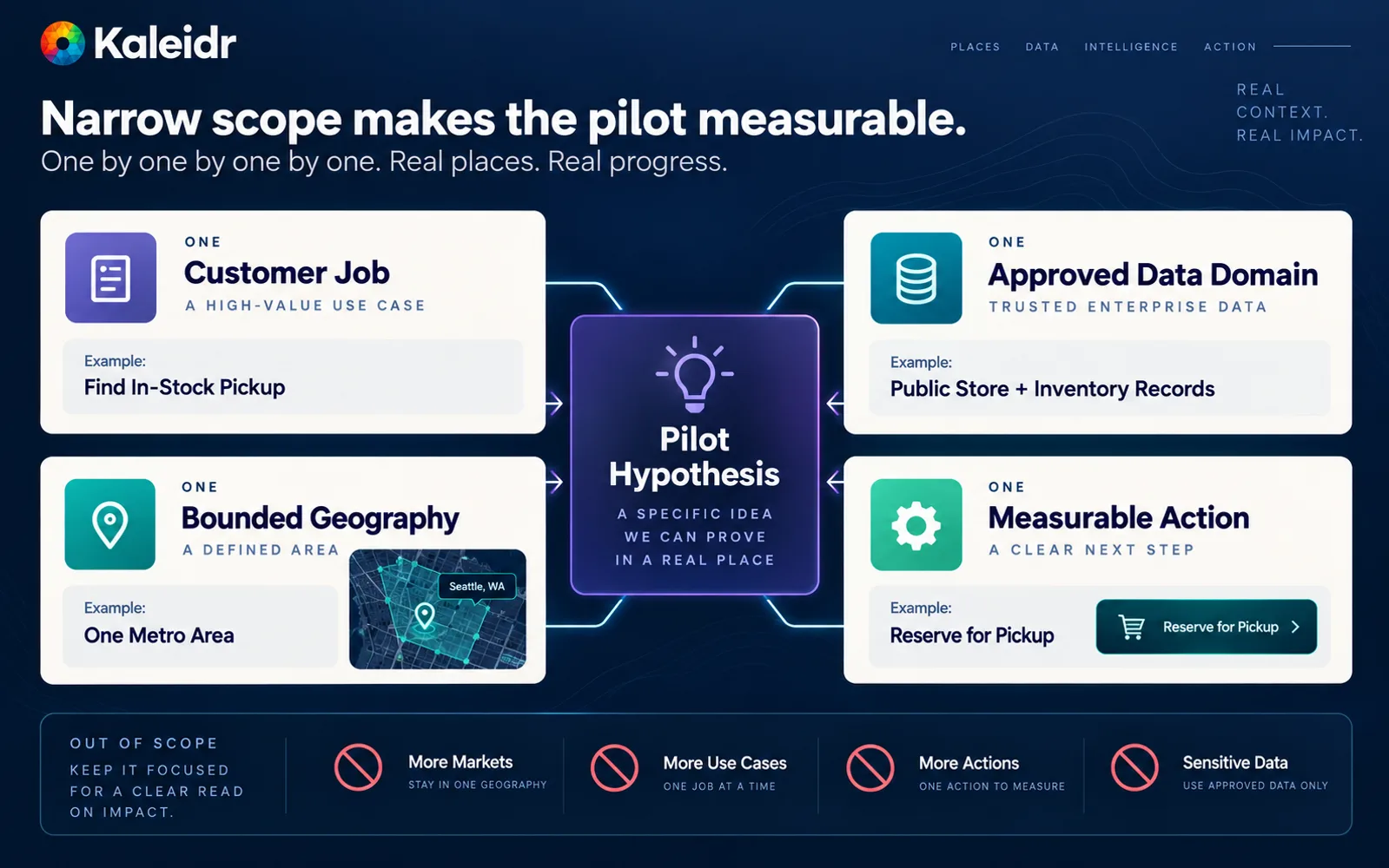
The first Spatial AI window should be one job, one data domain, one geography, and one action.
A four-to-eight-week window is a planning heuristic, not a Kaleidr service-level agreement. The useful constraint is that the team can name the job, the data owner, the geography, the action, and the scale gate before the first customer conversation is instrumented. If any of those five names is still a slogan, the work is still a prototype.
What Should a Spatial AI Pilot Prove?
Prove a completed task, not a longer conversation. A completed Spatial AI task typically has four observable steps: the assistant returns an eligible place, the map focuses or routes to that place, the customer or operator starts the host action, and no-result geography is visible when the catalog cannot fulfill the request. Conversation volume, session length, and model fluency can support diagnosis. Those engagement numbers do not by themselves show that the product found a place the organization can serve.
Hard filters belong before spatial ranking. A nearby candidate is unusable if the user is not authorized to see it, if the location is closed or out of stock, if the place sits outside the service area, or if travel time consumes the remaining appointment window. Private Location Data for AI Map Workflows sets the same order for tenant records: authorize, minimize, then calculate. Ranking among surviving candidates can use travel time, on-the-way relationship, and remaining capacity. The language model should explain that ranked shortlist rather than invent a closer pin that failed a hard filter.
Supported actions should be a short, host-validated list: focus a place, show a shortlist, show a walking or driving relationship, or open the host appointment, directions, or checkout page. Avoid arbitrary JavaScript or unbounded map commands from the model. Indoor turn-by-turn navigation, franchise-wide inventory sync, and native CRM writes are separate products. Do not make those capabilities a prerequisite for a first enterprise Spatial AI pilot, and do not treat this article as a second integration spec for those systems.
Measurement should stay geographic. Kaleidr currently documents map and place engagement, place comparison, spatial patterns, and activity that product, inventory, and growth teams can act on, documented on the Map Engagement and Location Analytics page. Host systems still own inventory and booking. Use that loop to find ZIP codes with in-scope searches and no eligible location, travel-time bands that lose the customer, and markets with demand and missing fields. Spatial Analytics vs. Web Analytics covers why pageviews alone cannot answer those questions. Suggested event names in this article are editorial recommendations, not documented automatic Kaleidr Analytics event names.
Where Does Kaleidr Fit in a Pilot Architecture?
Kaleidr is designed to attach conversational Spatial AI, map rendering, and analytics to maps and business systems the host already operates rather than to replace those systems. The Location Intelligence APIs and Map SDK page currently describes inference APIs, ranking, analytics, and SDKs that add chat, editing, custom tiles, and embeddable viewers to a stack the team already runs. Treat that page as Kaleidr's own positioning. The same page is not evidence that Kaleidr operates a native inventory ledger, CRM, hours feed, or appointment engine.
Current public attach documentation for conversational map interaction is Chat — attach AI to your map. The documented product="chat" mount sits over a map the host already renders and auto-detects Mapbox, MapLibre, or Google. Leaflet is not in that vendor list. The required scope is ai, and the documented minimum plan is Pro. Headless chat without a map is also documented; a first enterprise Spatial AI pilot still needs the map because the customer job is a place and an action, not a transcript. How to Add AI Chat to a Map covers renderer-specific attach steps as a separate how-to.
The Endpoints page currently lists SDK session exchange, streaming chat, route, POI enrichment, and design routes. The list does not currently publish a universal knowledge-upload, RAG-index, inventory-connect, or appointment-write route. Confirm the integration path for the deployment rather than treating marketing copy as an ingestion API. Auth & scopes currently distinguishes publishable browser keys from server keys, and treats vendor as a deliberate modifier for whether chat may consult uploaded vendor data. Vendor-scoped publishable keys belong only on data the host would show every visitor of that page. Rate sheets, cost basis, unreleased inventory, and anything that would embarrass the company on a public page do not belong behind a browser key.
In practice, the clean split is: Kaleidr coordinates conversational retrieval, map behavior, and analytics; the host remains authoritative for identity, inventory, eligibility, price, and the transaction. A Kaleidr implementation can support that split on an existing map. Depending on the configuration, a team without a production map can publish a Kaleidr map and still keep business systems as the system of record. Do not import tokens, copy customer credentials, or ask the language model which rows a user may see.
How Should Teams Evaluate and Gate Scale?
Evaluate the pilot on four editorial dimensions: usability, answer quality, operational ownership, and commercial value. Usability asks whether a customer or operator can complete the job without a specialist standing next to the map. Answer quality asks whether returned places are authorized, eligible, spatially correct, and current. Operational ownership asks whether named teams own the location directory, availability feed, authorization rule, and incident path. Commercial value asks whether the completed action is worth expanding. A high conversation count with low action starts fails the last dimension.
NIST's initial public draft of the TEVV-Athlon framework, announced 7 August 2026, describes a structured, customizable approach for assessing the real-world impact and outcomes of AI systems, and notes that the AI Risk Management Framework calls for test, evaluation, verification, and validation methodology (NIST, 2026). The document is a draft, not a finished Kaleidr certification. The useful implication for a Spatial AI pilot is narrower: customize evaluation to the job the product claims to complete, then collect evidence about that job's impact before copying the assistant into every market.
The following scorecard is editorial. Fill it from observed task metrics, source freshness, and host-system outcomes rather than from model fluency.
| Dimension | Pilot evidence | Weak signal |
|---|---|---|
| Usability | Task completed without specialist help | Long chats that never focus a place |
| Answer quality | Authorized, eligible, spatially correct places | Nearby-but-unusable recommendations |
| Operational ownership | Named data owner, incident path, and refresh cadence | A demo dataset with no production owner |
| Commercial value | Action started, booked, or handed off | Engagement without a host workflow |
| Scale readiness | Clear next job, dataset, market, or channel | "Roll it out everywhere" with no gate |
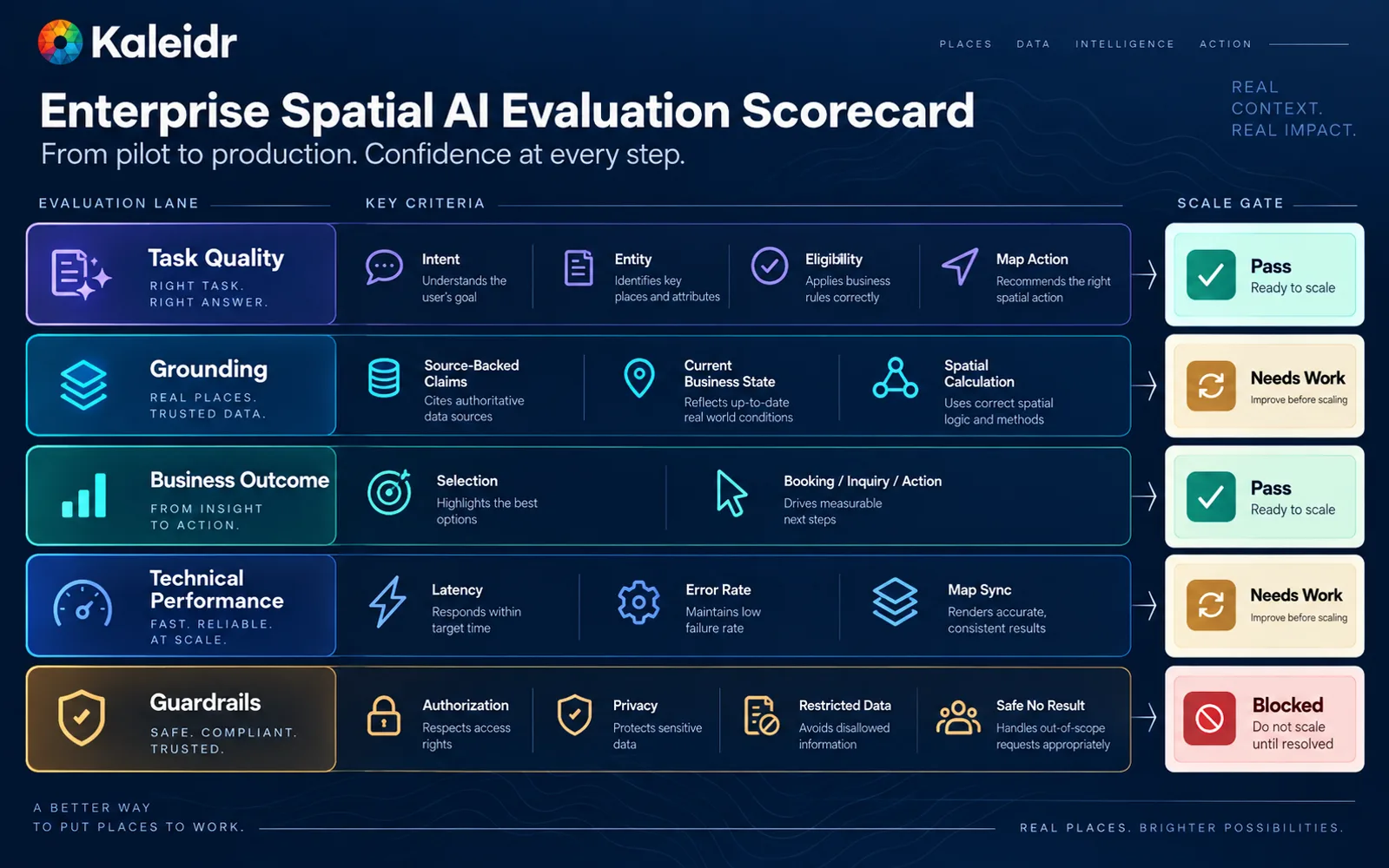
Scale only when the pilot is usable, accurate, operationally owned, and commercially justified.
Four gates follow from that table. Scale when the first job completes in production-shaped conditions and the next axis is named. Iterate when the job is right but ranking, coverage, or explanation quality is weak. Narrow when the window mixed too many jobs, datasets, or markets. Stop when the organization cannot name a data owner, cannot complete a host action, or cannot show that the result is better than the existing map search. Prompt injection, tool validation, and untrusted retrieved content remain host responsibilities even after a successful pilot. The application still has to refuse actions the model proposes outside the allowed set.
How Should a Successful Pilot Expand?
Expand one axis at a time. Additional customer jobs can reuse the same location directory and map. Additional data domains can reuse the same authorization and analytics. Additional geographies can reuse the same ranking policy with local coverage. Additional channels — web, in-app, kiosk, or partner embed — can reuse the same grounded shortlist rather than a second conversational stack. Copying the entire architecture into a new renderer, a new catalog, and a new workflow at once recreates the original demo problem at larger scale.
Keep the same systems of record while the footprint grows. Location identity, availability, and appointments should not fork into a parallel "AI copy" of the directory. Map SDK vs. Map API vs. Map Platform covers why attach versus replace is an integration choice, not a branding choice. A successful rollout still needs human confirmation on irreversible actions, auditability of which source produced a recommendation, and a path to withdraw a vendor-scoped key without waiting for a session to expire. Those controls belong in the host application and key policy, not in a prompt.
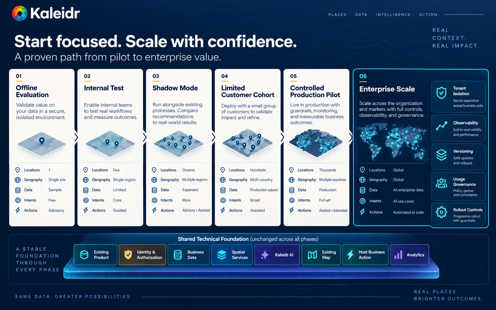
A successful Spatial AI pilot expands through more jobs, more data, more markets, and more channels, not through a second map stack.
The homepage sequence remains the expansion rule: start with a pilot, then scale when the evidence supports it. Explore Kaleidr Spatial AI to attach conversational location search on an existing map. Explore Kaleidr Enterprise to add SDKs and ranking to the stack you already operate. Explore Kaleidr Analytics to measure place engagement and geographic demand around that first job. Confirm the current public pages before treating any example in this article as a shipping contract.
FAQs
Why not start with a company-wide Spatial AI assistant?
A company-wide assistant mixes catalog search, eligibility, routing, policy, and several workflows. Each of those surfaces can fail independently, which makes the first result hard to measure and hard to staff. A bounded job in one geography produces evidence the organization can use to decide whether to scale, iterate, narrow, or stop.
What is the difference between a demo, a prototype, a pilot, and a rollout?
A demo shows that a map can talk. A prototype shows one happy-path query. A pilot shows one production-shaped job, one data domain, one geography, and one host action under named ownership. A rollout copies a proven window onto additional jobs, datasets, markets, or channels rather than inventing a second stack.
Can a Spatial AI pilot reuse an existing map?
Current Kaleidr attach documentation supports Mapbox, MapLibre, and Google maps the host already renders. Reusing the production map keeps place identity, viewport context, and analytics aligned with the customer application. Replacing the renderer is a separate decision and is not required to start.
How long should an enterprise Spatial AI pilot run?
A four-to-eight-week window is a planning heuristic, not a platform SLA. The useful constraint is that the team can name the job, data owner, geography, action, and scale gate before instrumenting the first production-shaped conversations.
What if the first use case is too small to matter?
A first window can be narrow and still commercial if the completed action is one the organization already values, such as an eligible location selected or an appointment started. Breadth without a completed task is the pattern that stalls Spatial AI programs.
Should a pilot measure AI map assistant engagement?
Conversation volume can be a supporting diagnostic. The primary metrics should remain task completion: eligible place returned, map action taken, host workflow started, and no-result geography. Engagement without a completed action is not evidence that the pilot is ready to scale.
Does Kaleidr replace inventory, CRM, or appointment systems?
Business systems should remain authoritative for inventory, permissions, prices, schedules, and transactions. Kaleidr is designed to coordinate conversational retrieval, map behavior, and analytics on top of those systems. Current public endpoint documentation does not publish a universal inventory or appointment-write API.
Do teams need a new map stack before starting?
A new map stack is not the recommended first step when the host already operates Mapbox, MapLibre, or Google. Attach conversational Spatial AI to the map customers already use, then expand channels after the first job works. A published Kaleidr map is an option when the team does not yet have a production canvas.
Can Kaleidr currently support a first enterprise Spatial AI pilot?
Current Kaleidr developer documentation supports attaching product="chat" to a host map, scoped keys, public chat and design endpoints, and map analytics. Confirm origin allowlists, ai scope, and vendor-scope policy for the data the pilot will expose. Confirm the host integration path for inventory, authorization, and the downstream action.
References
- Kaleidr. Build Your Own Spatial AI with Kaleidr. Accessed 18 September 2026. https://kaleidr.com/
- National Institute of Standards and Technology. Artificial Intelligence Risk Management Framework (AI RMF 1.0). 26 January 2023. https://www.nist.gov/publications/artificial-intelligence-risk-management-framework-ai-rmf-10
- National Institute of Standards and Technology. The TEVV-Athlon Framework for Evaluating AI Systems. Announced 7 August 2026. https://www.nist.gov/artificial-intelligence/ai-research/tevv-athlon-framework-evaluating-ai-systems
- Kaleidr. Location Intelligence APIs and Map SDK. Accessed 18 September 2026. https://kaleidr.com/enterprise
- Kaleidr. Chat — attach AI to your map. Developer documentation. Accessed 18 September 2026. https://docs.kaleidr.com/sdk/chat-attach
- Kaleidr. Endpoints. Developer documentation. Accessed 18 September 2026. https://docs.kaleidr.com/platform-api/endpoints
- Kaleidr. Auth & scopes. Developer documentation. Accessed 18 September 2026. https://docs.kaleidr.com/platform-api/auth-and-scopes
- Kaleidr. Map Engagement and Location Analytics. Accessed 18 September 2026. https://kaleidr.com/analytics
- Kaleidr. AI Map Chat for Customer Discovery. Accessed 18 September 2026. https://kaleidr.com/ai
- Kaleidr. Grounded Spatial AI for Business Data. Accessed 18 September 2026. https://kaleidr.com/blog/grounded-spatial-ai-business-data
- Kaleidr. Spatial AI for Multi-Location Businesses. Accessed 18 September 2026. https://kaleidr.com/blog/spatial-ai-for-multi-location-businesses
- Kaleidr. Map-Aware AI Assistant: How to Build One. Accessed 18 September 2026. https://kaleidr.com/blog/how-to-build-a-map-aware-ai-assistant
- Kaleidr. Private Location Data for AI Map Workflows. Accessed 18 September 2026. https://kaleidr.com/blog/private-location-data-for-ai-map-workflows
- Kaleidr. Spatial Analytics vs. Web Analytics. Accessed 18 September 2026. https://kaleidr.com/blog/spatial-analytics-vs-web-analytics
- Kaleidr. Map SDK vs. Map API vs. Map Platform. Accessed 18 September 2026. https://kaleidr.com/blog/map-sdk-vs-map-api-vs-map-platform
- Kaleidr. How to Add AI Chat to a Map. Accessed 18 September 2026. https://kaleidr.com/blog/add-ai-chat-mapbox-google-maps-maplibre
@misc{kaleidr_pilot_home_2026,
  title  = {Build Your Own Spatial AI with Kaleidr},
  author = {{Kaleidr}},
  year   = {2026},
  note   = {Accessed 18 September 2026},
  url    = {https://kaleidr.com/}
}

@techreport{nist_ai_rmf_2023,
  title       = {Artificial Intelligence Risk Management Framework (AI RMF 1.0)},
  author      = {{National Institute of Standards and Technology}},
  year        = {2023},
  month       = jan,
  number      = {NIST AI 100-1},
  institution = {National Institute of Standards and Technology},
  note        = {Published 26 January 2023; accessed 18 September 2026},
  url         = {https://www.nist.gov/publications/artificial-intelligence-risk-management-framework-ai-rmf-10},
  doi         = {10.6028/NIST.AI.100-1}
}

@misc{nist_tevv_athlon_2026,
  title  = {The TEVV-Athlon Framework for Evaluating AI Systems},
  author = {{National Institute of Standards and Technology}},
  year   = {2026},
  month  = aug,
  note   = {Initial public draft announced 7 August 2026; accessed 18 September 2026},
  url    = {https://www.nist.gov/artificial-intelligence/ai-research/tevv-athlon-framework-evaluating-ai-systems}
}

@misc{kaleidr_pilot_enterprise_2026,
  title  = {Location Intelligence APIs and Map SDK},
  author = {{Kaleidr}},
  year   = {2026},
  note   = {Accessed 18 September 2026},
  url    = {https://kaleidr.com/enterprise}
}

@misc{kaleidr_pilot_chat_attach_2026,
  title  = {Chat -- attach AI to your map},
  author = {{Kaleidr}},
  year   = {2026},
  note   = {Developer documentation; accessed 18 September 2026},
  url    = {https://docs.kaleidr.com/sdk/chat-attach}
}

@misc{kaleidr_pilot_endpoints_2026,
  title  = {Endpoints},
  author = {{Kaleidr}},
  year   = {2026},
  note   = {Developer documentation; accessed 18 September 2026},
  url    = {https://docs.kaleidr.com/platform-api/endpoints}
}

@misc{kaleidr_pilot_auth_2026,
  title  = {Auth \& scopes},
  author = {{Kaleidr}},
  year   = {2026},
  note   = {Developer documentation; accessed 18 September 2026},
  url    = {https://docs.kaleidr.com/platform-api/auth-and-scopes}
}

@misc{kaleidr_pilot_analytics_2026,
  title  = {Map Engagement and Location Analytics},
  author = {{Kaleidr}},
  year   = {2026},
  note   = {Accessed 18 September 2026},
  url    = {https://kaleidr.com/analytics}
}

@misc{kaleidr_pilot_ai_2026,
  title  = {AI Map Chat for Customer Discovery},
  author = {{Kaleidr}},
  year   = {2026},
  note   = {Accessed 18 September 2026},
  url    = {https://kaleidr.com/ai}
}

@misc{kaleidr_pilot_grounded_2026,
  title  = {Grounded Spatial AI for Business Data},
  author = {{Kaleidr}},
  year   = {2026},
  note   = {Accessed 18 September 2026},
  url    = {https://kaleidr.com/blog/grounded-spatial-ai-business-data}
}

@misc{kaleidr_pilot_multilocation_2026,
  title  = {Spatial AI for Multi-Location Businesses},
  author = {{Kaleidr}},
  year   = {2026},
  note   = {Accessed 18 September 2026},
  url    = {https://kaleidr.com/blog/spatial-ai-for-multi-location-businesses}
}

@misc{kaleidr_pilot_map_aware_2026,
  title  = {Map-Aware AI Assistant: How to Build One},
  author = {{Kaleidr}},
  year   = {2026},
  note   = {Accessed 18 September 2026},
  url    = {https://kaleidr.com/blog/how-to-build-a-map-aware-ai-assistant}
}

@misc{kaleidr_pilot_private_location_2026,
  title  = {Private Location Data for AI Map Workflows},
  author = {{Kaleidr}},
  year   = {2026},
  note   = {Accessed 18 September 2026},
  url    = {https://kaleidr.com/blog/private-location-data-for-ai-map-workflows}
}

@misc{kaleidr_pilot_spatial_analytics_2026,
  title  = {Spatial Analytics vs. Web Analytics},
  author = {{Kaleidr}},
  year   = {2026},
  note   = {Accessed 18 September 2026},
  url    = {https://kaleidr.com/blog/spatial-analytics-vs-web-analytics}
}

@misc{kaleidr_pilot_map_sdk_2026,
  title  = {Map SDK vs. Map API vs. Map Platform},
  author = {{Kaleidr}},
  year   = {2026},
  note   = {Accessed 18 September 2026},
  url    = {https://kaleidr.com/blog/map-sdk-vs-map-api-vs-map-platform}
}

@misc{kaleidr_pilot_add_ai_chat_2026,
  title  = {How to Add AI Chat to a Map},
  author = {{Kaleidr}},
  year   = {2026},
  note   = {Accessed 18 September 2026},
  url    = {https://kaleidr.com/blog/add-ai-chat-mapbox-google-maps-maplibre}
}