
Spatial AI applies artificial intelligence to spatial context: where things are, what is nearby, how places relate, how people move through space, and which geographic conditions matter to a decision. In mapping products, it can interpret a natural-language request, retrieve authorized place or business data, apply spatial ranking, and return a grounded map action. The term spans maps, GeoAI, robotics, cities, and Earth science, so meaning depends on scale.
The sections below cover definitions, scales, related terms, core capabilities, grounding, language-model limits, use cases, Kaleidr surfaces, evaluation, and common mistakes. Related product context lives on Kaleidr Spatial AI and Kaleidr Enterprise. For the product-category taxonomy, see AI Mapping. For stack context, see Digital Mapping.
Spatial AI essentials
- Umbrella term: One label across maps, GeoAI, robotics, cities, and Earth observation.
- Intent ≠ calculation: Models interpret; spatial engines compute; business systems validate.
- Ground before plotting: Stable IDs, sources, and eligibility beat fluent prose on a map.
- Hard filters first: Closed or ineligible records must not rank because the description sounds good.
- Measure outcomes: Place selected and workflow completed beat prompt counts.
What Is Spatial AI?
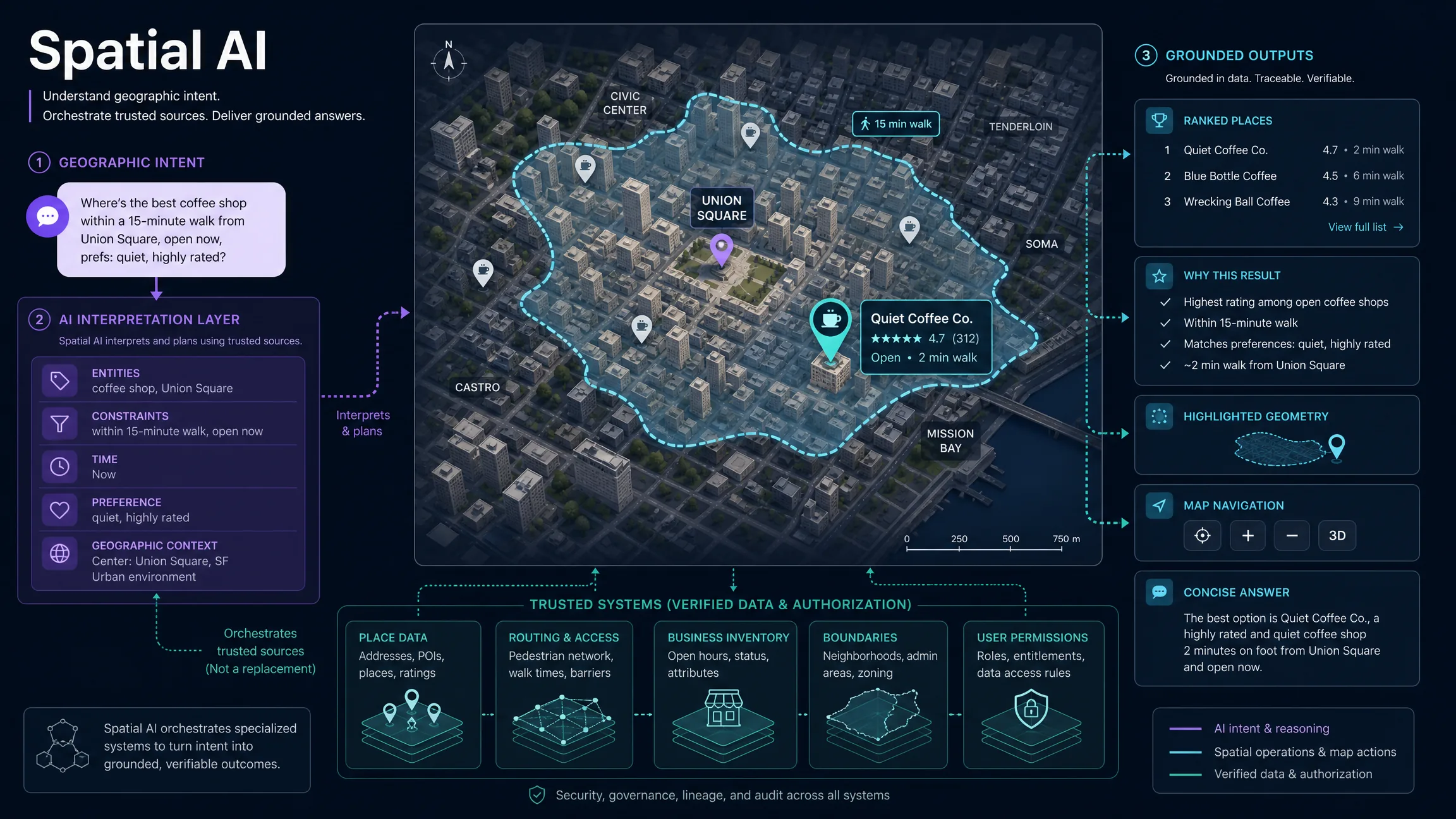
Spatial AI is artificial intelligence that can use information about space, location, relationships, movement, or physical context as part of understanding or decision-making. For a map product, that can mean understanding where a user is searching, which places fall inside an area, what is near a selected location, which destinations are reachable within a travel-time limit, how a candidate relates to transit or demand, what a visible map region contains, and how several geographic conditions should affect a recommendation. Kaleidr defines spatial AI in product context as AI applied to places and location data—understanding what a place is, what is nearby, and why it may be relevant—and combines natural-language place exploration, map interaction, creation, personalization, and sharing (Spatial AI). A 2025 survey of language-model-powered spatial intelligence frames the research field across embodied agents, urban environments, and Earth science rather than as one narrow mapping problem (Feng et al., 2025). Treat spatial AI as an umbrella term, not a single standardized API or model class.
A conventional text search can match words. A spatial question often contains relationships that must be computed or resolved—for example, bookstores within a fifteen-minute walk of a hotel that are open this evening combines entity type, origin, reachability, travel mode, time, and operating status. A keyword system can recognize “bookstore,” but a robust spatial AI workflow still needs place identity, coordinates, routing or travel time, opening-hour data, user context, spatial filtering, ranking, and map state. Spatial AI is therefore not simply a general chat model with a map attached.
Across Which Scales Does Spatial AI Work?
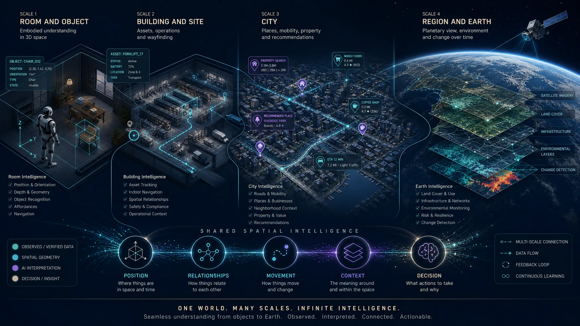
The phrase is used for problems at very different scales. At object and room scale, robotics, embodied AI, AR, and computer vision involve depth, object position, orientation, occlusion, navigation, manipulation, scene understanding, and 3D world representation. Building and site scale covers indoor navigation, warehouses, facilities, construction, digital twins, and asset positioning. City scale supports place discovery, mobility, store selection, real-estate search, urban planning, and neighborhood analysis. Regional and global scale includes satellite imagery, land-use analysis, climate and environmental monitoring, agriculture, disaster assessment, infrastructure, and Earth observation. The Feng et al. survey explicitly frames language-model-powered spatial intelligence across embodied, urban, and Earth-science scales.
How Does Spatial AI Relate to Nearby Terms?
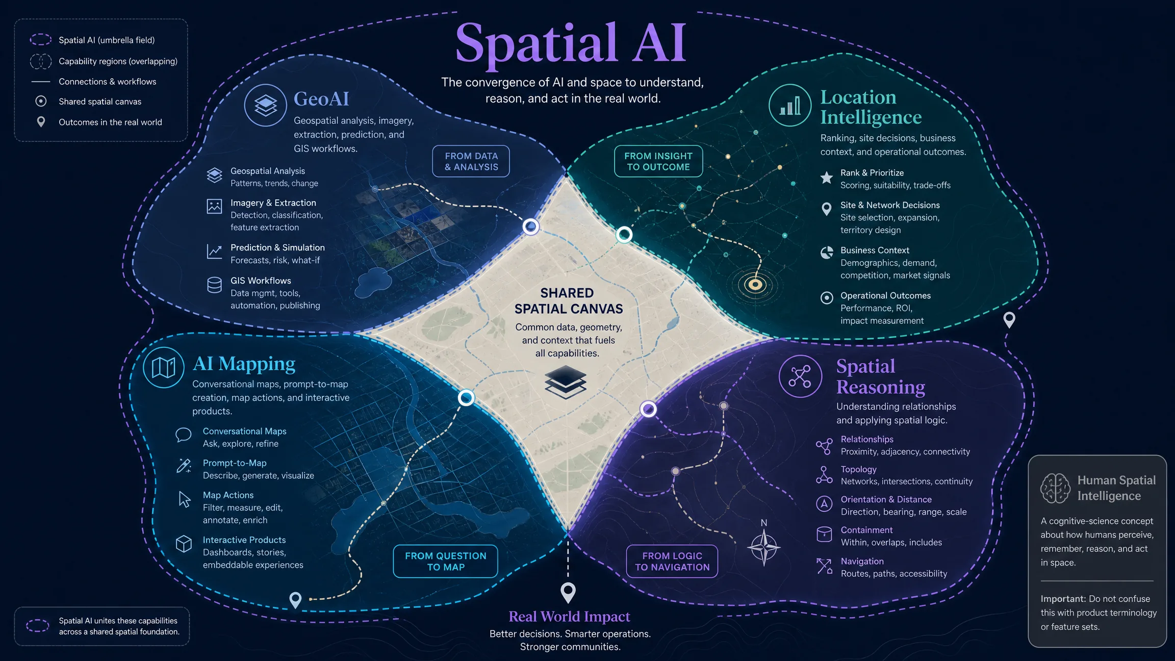
Spatial intelligence has a long history in cognitive science as a human ability to represent space, understand relations, rotate objects, or navigate. In current AI research, machine spatial intelligence can describe a system’s ability to perceive, represent, reason about, and act within spatial environments. Spatial AI is the practical technology label for systems that apply AI methods to spatial information and tasks. Neither phrase should be assumed to mean only geographic maps.
GeoAI, or geospatial artificial intelligence, is more specifically tied to geospatial data, GIS, Earth observation, and geographic analysis. Esri defines GeoAI as the application of AI fused with geospatial data, science, and technology to accelerate understanding of business opportunities, environmental impacts, and operational risks (What Is GeoAI?). Common tasks include feature extraction, imagery classification, object detection, change detection, clustering, prediction, spatial pattern analysis, and forecasting. Spatial AI can include those tasks and can also include conversational place search, map-aware recommendations, natural-language map creation, and location-aware assistants inside retail or real-estate applications. A useful shorthand is that GeoAI is a major branch of spatial AI focused on geographic and geospatial data, while boundaries are not formally standardized.
Location intelligence usually focuses on using location data to improve a business or operational decision—fulfillment location, site selection, commute-fit properties, service-area membership, or traveler destination matching. Spatial AI is a broader technology layer; location intelligence is often the decision outcome after intent interpretation, authorized data retrieval, and ranking. Geospatial intelligence (GEOINT) has a specific institutional meaning in government and defense; commercial software sometimes uses the phrase more broadly, but spatial AI should not be presented as a synonym for GEOINT. AI mapping describes AI applied to map creation, map interaction, geographic analysis, imagery, location ranking, or spatial operations—one visible product category built on spatial AI capabilities. See AI Mapping for that product taxonomy.
What Capabilities Does a Spatial AI System Need?
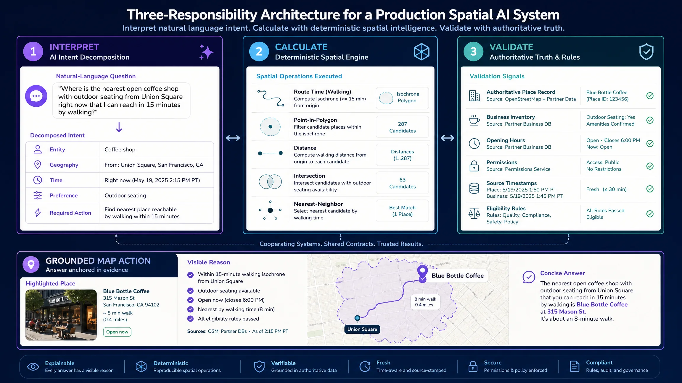
A useful system usually combines several capabilities. Spatial understanding must represent relationships such as inside, near, along, intersects, reachable from, within a radius, or within a travel-time area. Research on geospatial reasoning continues to show that foundation models can struggle with exact geometry and topological relations, which is one reason deterministic geospatial computation remains important (Ji et al., 2025). Place and entity resolution must turn ambiguous phrases into structured entities with stable identifiers, geometry or coordinates, type, administrative context, and source. Context interpretation must distinguish traveler preferences from logistics constraints or real-estate criteria before geography becomes useful. Spatial computation should handle point-in-polygon, nearest neighbor, buffer, intersection, routing, travel-time matrices, distance, containment, coverage, and clustering when precision matters—the model can decide which operation is relevant, while a geographic engine performs the calculation. Ranking should separate hard eligibility from soft preference so a closed store does not become the top result because a description sounds appealing. Conversational products also need map and conversation state for follow-ups, and structured outputs that can move the camera, highlight geometry, filter layers, draw routes, open a place, or trigger a host workflow.
Why Are Grounding and Deterministic Calculation Required?
A spatial answer can look convincing while being geographically wrong, and the risk increases when the answer is plotted on a map. A grounded result should preserve stable place IDs, coordinates or geometry, source, timestamp, factual attributes, reason for inclusion, uncertainty, and permitted action. The prose explanation can be generated from the record; the factual record should not be reconstructed from prose. Language models can understand many geographic concepts and extract spatial meaning from text, but exact spatial reasoning remains an active research problem. A 2026 agentic-geospatial study argues that language-model-based agents can fall back on pattern matching or web search instead of genuine geospatial computation, motivating executable spatial workflows grounded in scientific concepts (Bao et al., 2026). The practical architecture is to use the model to interpret and orchestrate, and to use spatial systems to calculate and validate. For a simple distance between two points, a geographic computation is more appropriate than asking a language model to estimate the answer.
Where Is Spatial AI Useful—and When Is It Unnecessary?
Place discovery is one of the clearest consumer applications: translating a quiet waterfront restaurant convenient from a hotel into category, origin, area, travel constraint, preference, time, and current place data, then showing map results with reasons. Retail can combine store locations, eligibility, hours, inventory, pickup, and travel time while keeping the store database authoritative for operating status and inventory. Real estate can combine listing inventory, route-time calculations, amenity context, and ranking while keeping hard listing filters deterministic. Tourism and hospitality can answer walking-distance and preference questions grounded in an approved destination catalog. Mobility and logistics can interpret route constraints and service zones without bypassing vehicle rules, capacity, legal restrictions, or human oversight. At regional scales, NASA Earthdata describes AI and machine learning as tools for searching large Earth-observation datasets to find relationships and improve discovery and analysis (Earth Observation Data and AI). Map creation can turn a prompt into an initial spatial structure that authors still verify for identity, coordinates, labels, rights, and accessibility; Kaleidr Studio uses a Prompt → Process → Refine → Deploy workflow for interactive maps.
Not every location task needs AI. Deterministic UI is usually better for clear requirements such as stores within five kilometers, active parcels, a known bus route, a plotted coordinate, or restaurants open now. Spatial AI becomes more valuable when language is ambiguous, several constraints interact, users need follow-ups, preferences are hard to encode as fixed filters, or intent must translate into multiple geographic operations.
How Does Kaleidr Apply Spatial AI?
Kaleidr Spatial AI lets users ask questions, discover places, create maps, personalize them, and share interactive map experiences across hospitality, tourism, retail, real estate, mobility, and other place-based workflows. Studio converts a map concept into an editable spatial structure with visual refinement and publishing. Analytics measures map, audience, and place engagement. Developer and Enterprise surfaces provide AI map chat, published viewers, designed basemaps, and an embedded editor, including chat attached to an existing Mapbox, Google Maps, or MapLibre implementation so the host retains renderer and application workflow (developer documentation). For private business products, the host should continue to own identity, permissions, authoritative business data, tenancy, persistence, and consequential actions. Retrieve least-privilege records after authorization, separate publishable browser keys from backend server keys, and scope every tool the AI can invoke. Related implementation guides include What Is a Location Intelligence API?, What Is an AI Map SDK?, and AI chat on Mapbox, Google Maps, and MapLibre.
How Should Teams Evaluate Spatial AI?
Define the geographic task before evaluating abstract “AI quality.” For each important claim, name the authoritative source—approved place database, first-party store system, property inventory, routing service, business rules, or spatial database. Separate what the AI interprets, what a spatial engine calculates, and what a business system validates. Test ambiguous geography: duplicate city names, renamed places, boundary edges, multilingual names, and multiple branches. Test no-result behavior so the system can say that no verified result satisfies all constraints rather than manufacturing a plausible answer. Measure grounded-result rate, place-resolution accuracy, invalid-coordinate rate, stale-data rate, ranking acceptance, and outcomes such as place selected, directions opened, map saved, listing shortlisted, booking started, store chosen, or workflow completed. The north-star metric should reflect the geographic task, not the number of AI prompts.
Which Mistakes Should Teams Avoid?
| Mistake | What happens | Better approach |
|---|---|---|
| Calling every map feature AI | Product positioning becomes vague | Identify the specific AI capability |
| Asking a language model to calculate exact geometry | Spatial accuracy becomes unreliable | Use deterministic spatial operations |
| Treating model knowledge as current place data | Hours, locations, or inventory become stale | Retrieve approved current records |
| Mixing eligibility and ranking | Invalid options can rank highly | Filter hard constraints first |
| Sending private data without authorization | Sensitive records can leak | Retrieve least-privilege data after auth |
| Hiding sources | Users cannot judge evidence | Preserve IDs, sources, and timestamps |
| Using chat for simple filters | UX becomes slower | Keep deterministic controls where they work |
| Measuring prompt count | Activity is mistaken for value | Measure completed geographic tasks |
| Letting the AI trigger unrestricted actions | Tool access becomes a security risk | Scope and validate every action |
Final Verdict
Spatial AI is not one model and not one map feature. The category covers AI systems that use spatial context to understand environments, interpret geographic intent, retrieve relevant information, reason about relationships, rank locations, and coordinate actions. For map and location products, the strongest architecture is usually AI interprets intent, trusted systems provide facts, spatial engines calculate relationships, the application validates permissions, and the map makes the result visible. The interpret-calculate-validate boundary is what turns a conversational map from a convincing demo into a reliable spatial product. Kaleidr applies this model to place exploration, prompt-based map creation, embedded map AI, spatial analytics, and business integrations while allowing existing mapping and business systems to retain their appropriate responsibilities.
Explore Spatial AI With Kaleidr
Ask location-based questions, discover places, create maps, personalize them, and share the result. Explore Kaleidr Spatial AI to try the experience, then review the developer documentation when you need chat or embeds inside an existing product.
FAQs
What is spatial AI?
Spatial AI is artificial intelligence that understands or uses spatial context such as location, proximity, distance, containment, movement, orientation, or geographic relationships to answer questions, make recommendations, analyze environments, or drive actions.
Is spatial AI the same as GeoAI?
Not exactly. GeoAI focuses specifically on applying AI to geospatial data, GIS, remote sensing, and geographic analysis. Spatial AI is a broader term that can also include robotics, 3D environments, embodied agents, conversational maps, and other spatially aware AI systems.
Is spatial AI the same as location intelligence?
No. Location intelligence focuses on decisions derived from location and geographic context. Spatial AI is one technology approach that can power location-intelligence workflows.
Is spatial AI the same as spatial reasoning?
Spatial reasoning is a capability: understanding and reasoning about spatial relationships. Spatial AI is a broader system category that may combine spatial reasoning with perception, data retrieval, ranking, mapping, or actions.
Can large language models understand geography?
They can understand many geographic concepts and extract spatial relationships from language, but exact geometry and topological reasoning remain active research problems. Production systems should use dedicated spatial functions for calculations that require precision.
Can spatial AI use private business data?
Yes, when the application retrieves only authorized records and enforces user, tenant, field, and tool permissions. Private data should remain governed by the host system.
Does spatial AI replace GIS or map providers?
No. GIS can remain authoritative for spatial data, analysis, editing, and governance. A spatial-AI layer can use an existing renderer, geocoder, routing system, place database, and business systems—including Mapbox, Google Maps, or MapLibre maps an application already runs.
When is spatial AI useful?
It is most useful when a task contains ambiguous language, several interacting constraints, contextual preferences, follow-up questions, or a need to translate intent into multiple geographic operations.
When should I avoid using spatial AI?
Use conventional search, filters, or explicit spatial functions when the task is simple and deterministic. AI is not automatically better for queries that can be represented cleanly with existing controls.
How should spatial AI be measured?
Measure grounded-result quality and the completion of the geographic task: selecting a useful place, saving a map, opening directions, shortlisting a property, choosing a store, completing an operational workflow, or another real outcome.
References
- Bao, Riyang, et al. Spatial-Agent: Agentic Geo-spatial Reasoning with Scientific Core Concepts. arXiv:2601.16965, 2026. https://arxiv.org/abs/2601.16965
- Esri. What Is GeoAI? Accessed 15 August 2026. https://www.esri.com/en-us/capabilities/geoai/overview
- Feng, Jie, et al. A Survey of Large Language Model-Powered Spatial Intelligence Across Scales: Advances in Embodied Agents, Smart Cities, and Earth Science. arXiv:2504.09848, 2025. https://arxiv.org/abs/2504.09848
- Ji, Yuhan, Song Gao, Ying Nie, Ivan Majić, and Krzysztof Janowicz. Foundation Models for Geospatial Reasoning: Assessing the Capabilities of Large Language Models in Understanding Geometries and Topological Spatial Relations. arXiv:2505.17136, 2025. https://arxiv.org/abs/2505.17136
- Kaleidr. AI Maps You Can Talk To — Spatial AI. Accessed 15 August 2026. https://kaleidr.com/ai
- Kaleidr. Create Custom Maps with AI Map Maker. Accessed 15 August 2026. https://kaleidr.com/studio
- Kaleidr. Build with Kaleidr. Developer documentation. Accessed 15 August 2026. https://docs.kaleidr.com/
- NASA Earthdata. Earth Observation Data and Artificial Intelligence. Accessed 15 August 2026. https://www.earthdata.nasa.gov/learn/earth-observation-data-basics/artificial-intelligence
@article{feng2025spatialintelligence,
  title   = {A Survey of Large Language Model-Powered Spatial Intelligence Across Scales: Advances in Embodied Agents, Smart Cities, and Earth Science},
  author  = {Feng, Jie and Zeng, Jinwei and Long, Qingyue and others},
  year    = {2025},
  journal = {arXiv preprint arXiv:2504.09848},
  url     = {https://arxiv.org/abs/2504.09848}
}

@article{ji2025geospatialreasoning,
  title   = {Foundation Models for Geospatial Reasoning: Assessing the Capabilities of Large Language Models in Understanding Geometries and Topological Spatial Relations},
  author  = {Ji, Yuhan and Gao, Song and Nie, Ying and Maji\'{c}, Ivan and Janowicz, Krzysztof},
  year    = {2025},
  journal = {arXiv preprint arXiv:2505.17136},
  url     = {https://arxiv.org/abs/2505.17136}
}

@article{bao2026spatialagent,
  title   = {Spatial-Agent: Agentic Geo-spatial Reasoning with Scientific Core Concepts},
  author  = {Bao, Riyang and Yang, Cheng and Yu, Dazhou and Tang, Zhexiang and Mai, Gengchen and Zhao, Liang},
  year    = {2026},
  journal = {arXiv preprint arXiv:2601.16965},
  url     = {https://arxiv.org/abs/2601.16965}
}

@misc{esri_geoai,
  title  = {What Is GeoAI?},
  author = {{Esri}},
  note   = {Accessed 15 August 2026},
  url    = {https://www.esri.com/en-us/capabilities/geoai/overview}
}

@misc{nasa_earthdata_ai,
  title  = {Earth Observation Data and Artificial Intelligence},
  author = {{NASA Earthdata}},
  note   = {Accessed 15 August 2026},
  url    = {https://www.earthdata.nasa.gov/learn/earth-observation-data-basics/artificial-intelligence}
}

@misc{kaleidr_spatial_ai_2026,
  title  = {AI Maps You Can Talk To -- Spatial AI},
  author = {{Kaleidr}},
  note   = {Accessed 15 August 2026},
  url    = {https://kaleidr.com/ai}
}

@misc{kaleidr_studio_spatial_ai_2026,
  title  = {Create Custom Maps with AI Map Maker},
  author = {{Kaleidr}},
  note   = {Accessed 15 August 2026},
  url    = {https://kaleidr.com/studio}
}

@misc{kaleidr_developer_spatial_ai_2026,
  title  = {Build with Kaleidr},
  author = {{Kaleidr}},
  note   = {Developer documentation; accessed 15 August 2026},
  url    = {https://docs.kaleidr.com/}
}