
Spatial AI data integration connects CRM, inventory, booking, transit, and sensor systems to a location decision while each system keeps the fact it already owns. A map can show a store, a bus, and a booking only when identity, freshness, and permission survive the join. The useful design picks a pattern for each kind of change, then explains the result from those records.
The sections below separate six ways data can move, then apply them to transit, sensors, bookings, and private records. A single nightly file can still be the right choice for a catalog that rarely changes. A live position needs a different contract.
Spatial AI data integration essentials
- Name the owner: Each field has a system of record, a canonical ID, and a freshness rule before any connector is chosen.
- Match the pattern to the change: Batch, live lookup, events, streams, spatial feature APIs, and validated write-back answer different jobs.
- Bind stable facts early: Store identity and geometry can narrow the set. Inventory, hours, and traffic belong at the last responsible moment.
- Keep permission ahead of the join: A spatial join of every private record is already a disclosure, even if the answer hides some rows.
- Leave the transaction at home: A recommendation can name a place. The host system revalidates, confirms, and records the booking or the payment.
What Is Spatial AI Data Integration?
Spatial AI data integration is the work of bringing operational records to a location decision without flattening them into one anonymous feed. CRM holds the customer. Inventory holds stock. A booking system holds availability and the transaction. Transit holds a planned network and a live state. IoT holds observations. The map is where those facts become a place, a route, a rank, and an explanation. The integration fails when a store identifier changes meaning halfway through that path, or when a stale quantity is treated as a current one.
Five jobs sit between the source and the experience. Identity resolves the same store, customer, or asset across systems. Authorization decides which tenant, object, and field may enter the request. Normalization puts those fields into one schema with location and time attached. Freshness records when a batch, a lookup, or a stream last spoke. A spatial join then fuses the authorized rows by place. The cover diagram follows that order, from the five sources into one map with ranked places, a route, an explanation, and a validated action.
Treat the sample callout on that diagram as an illustration. "Customer near store," "high inventory," and "next transit in 6 min" show the kind of sentence a grounded result can support. Those phrases are not a measured Kaleidr outcome, and the map is not a claim that one product already stores every source.
Why Does One Product Need Six Patterns?
One location product often needs six integration patterns because the facts change at different speeds and carry different risk. A batch or snapshot fits a slow catalog. A live lookup fits a volatile fact that must be current before anyone recommends or acts. An event fits a meaningful business change, such as a store closing for the afternoon. A stream fits high-frequency operational state, such as a moving vehicle. A spatial feature API fits a queryable geographic collection. A validated write-back fits an action that has to land in the system of record. Forcing all six through one nightly file, or through one language-model call, drops the distinction the decision depends on.
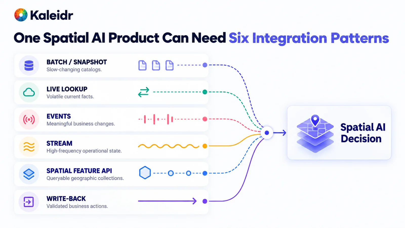
The six patterns describe how a fact moves, not which vendor wins. Batch carries a slow snapshot. Live lookup, events, and streams carry faster change. A spatial feature API exposes geographic collections, and write-back returns a validated action. The diagram is an architecture split, not a Kaleidr score.
OGC API - Features is one practical shape for the fifth pattern. The standard describes a geospatial API for feature data, which suits places, boundaries, and other collections a product needs to query rather than copy in full (OGC, 2026). Use that shape when the collection is already geographic and the questions are spatial. A customer tier, a price, or a booking confirmation still belongs in the system that owns it, reached by lookup, event, or write-back. Standards help when they match the job. A logo on a diagram does not.
Who Should Own Each Field?
Choose the owner before choosing the connector. A useful table names the data domain, the system of record, the canonical identifier, how fresh the fact must be, the integration pattern, and what the AI layer may do with it. Store identity and coordinates can live in a location master and move by batch, because they are stable. Inventory can live in the inventory system, keyed by SKU and store, and move by live lookup, because stock changes. Hours can come from a scheduling system on a schedule. Customer tier can come from the CRM as an event. Travel time can come from a routing service on demand. A booking and a payment stay in the booking system and the point of sale, and the AI layer may summarize them without becoming the ledger.
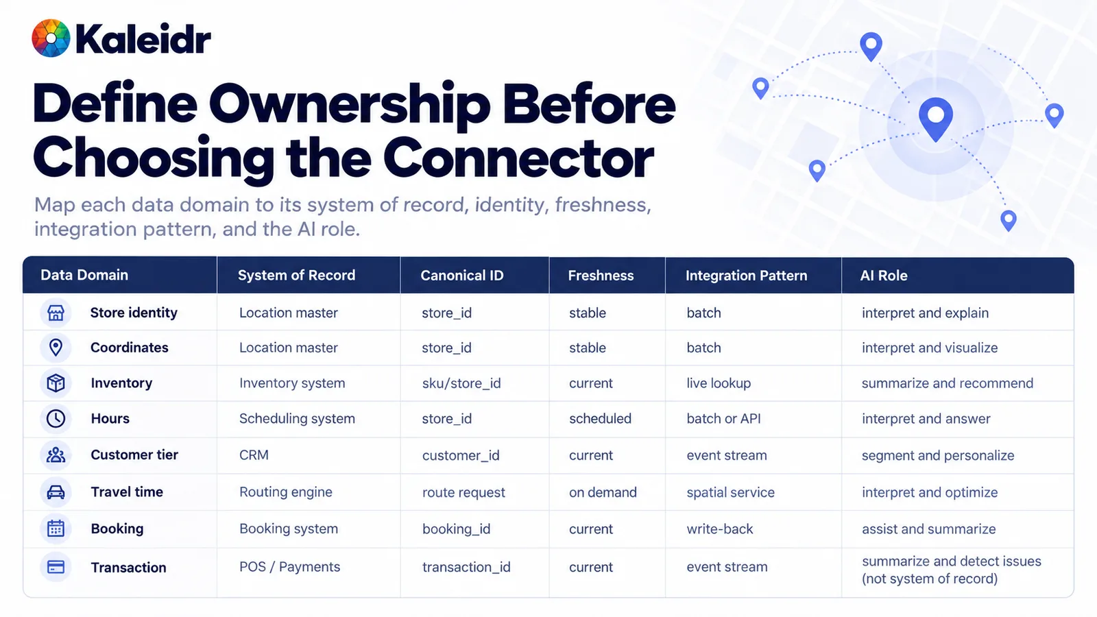
Each row ties a domain to the system that owns it. Stable place facts use a batch and a store identifier. Volatile stock, hours, tier, travel time, and bookings use faster patterns. The AI column limits the layer to interpretation, summary, or assistance. The table is a planning grid, not a Kaleidr export.
The same store needs one canonical identifier after every enrichment. A source system may use its own key, and the integration maps that key rather than inventing a new store for each feed. Address and coordinate authority should be explicit, so a geocoder does not silently override a surveyed location. Unknown is a different state from false: a missing hours record is not proof that the store is closed. Carry source, schema version, and observation time beside the normalized fields so a later explanation can say which record it used.
Why Bind Stable Facts Early and Volatile Facts Late?
Stable data can narrow the search before anyone pays for a live call. A nightly snapshot of store locations, a geographic filter to the stores on the route, and only then a live inventory check, an hours check, and a routing rank is a cheaper and safer order than asking every API about every store. Volatile facts belong at the last responsible moment, because a quantity or a closure can change between the nightly file and the customer's question. The figure walks an illustrative path: a snapshot, a corridor filter, an in-stock lookup, an hours check, a detour rank, and one suggested stop. The counts and the detour minutes on that figure are illustration only.
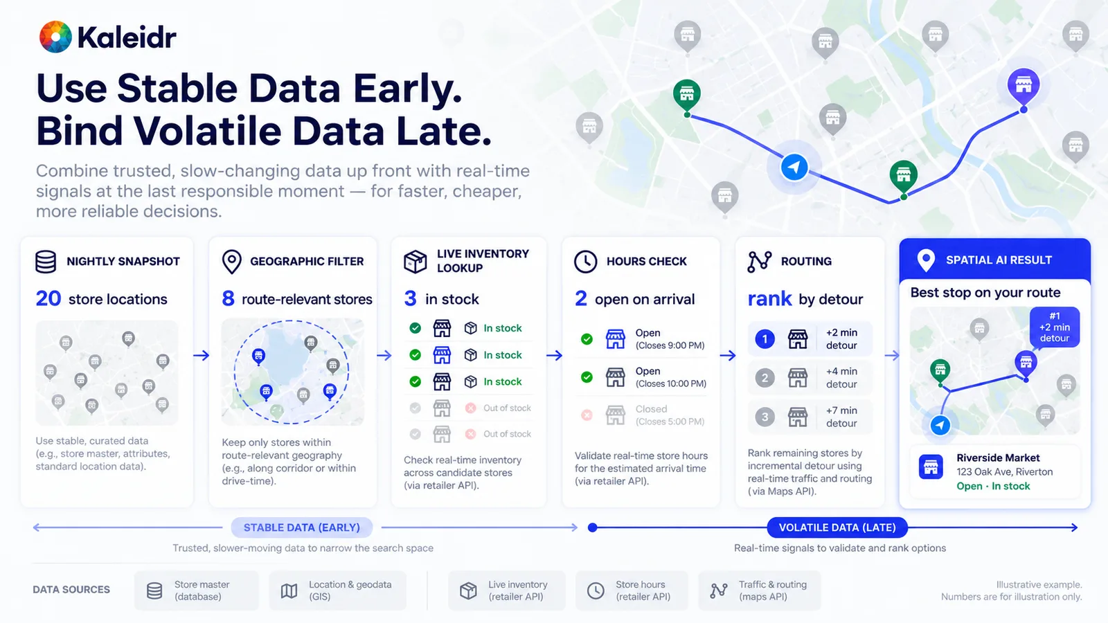
Stable place data narrows the set before live calls begin. Inventory, hours, and traffic are checked late, on the remaining candidates. The final card is one suggested stop with a sample name and a sample detour. The numbers on the figure are illustrative, not a Kaleidr measurement.
Keep spatial calculations out of the source adapters. The inventory API returns stock. The routing service returns travel time. Eligibility removes a closed or out-of-stock store before ranking sorts the rest. The language model can interpret the request and explain the remaining choice. Asking that model to invent the distance, the stock count, or the opening hours recreates the fact in the least reliable place. If the recommendation changes after the nightly import, the team should know which dataset version supplied the store list.
What Should an Event Change?
An event says that something meaningful changed. A store closed for the afternoon, a listing went active, a booking was canceled, or a service area moved. The producer publishes that change, a broker fans it out, and consumers update current state, a search index, a map layer, and a retrieval cache. An event is not a complete database, and the consumer still needs state semantics: whether the payload is the full new record, a changed field, or only an identifier that requires a later lookup. CloudEvents describes event data in a common way so publishers stop inventing a new envelope for every consumer (CloudEvents, 2026).
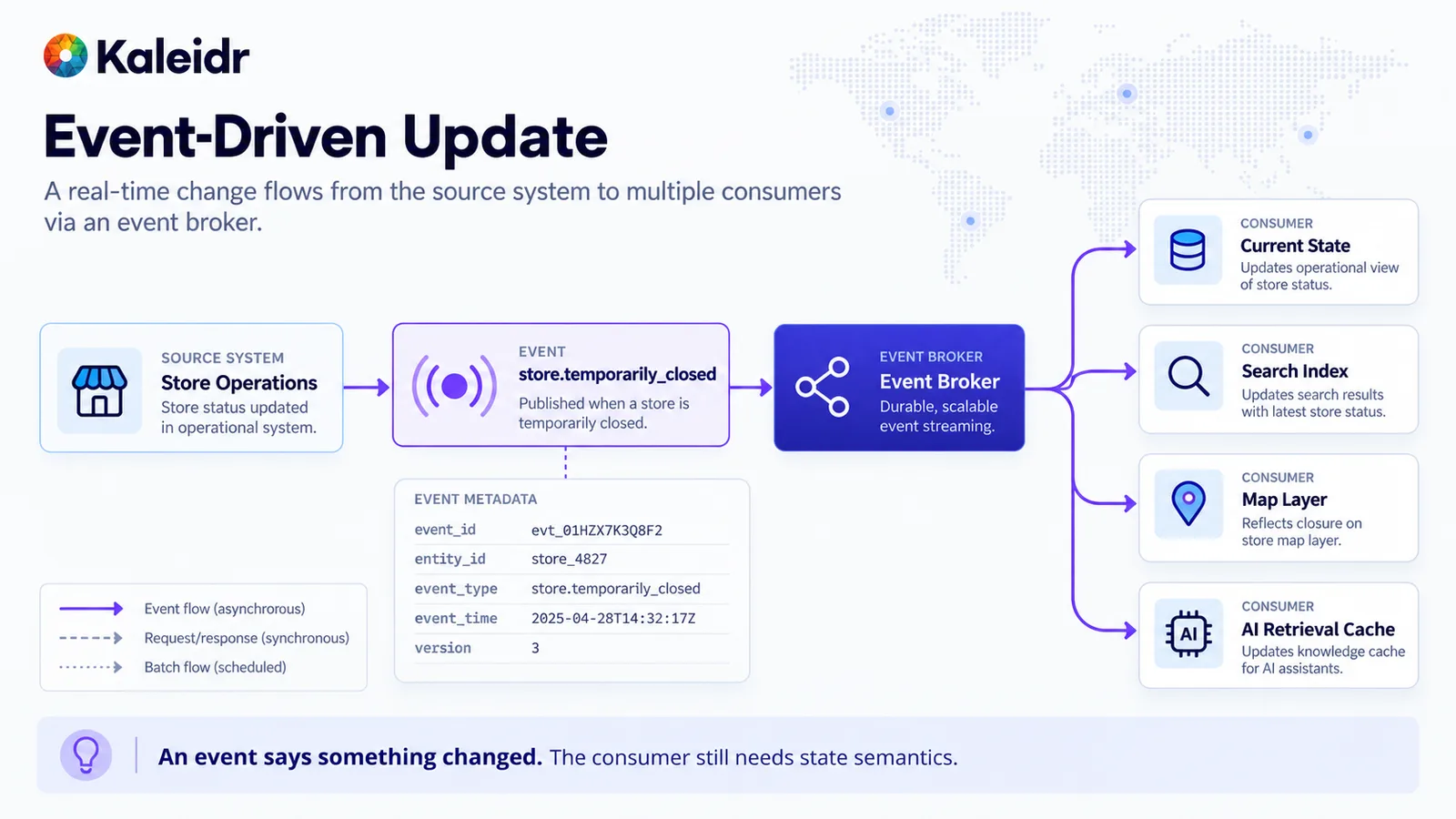
The source publishes one business change, and the broker delivers it to several consumers. Metadata such as an event identifier, entity, type, time, and version travels with the notice. The sample identifiers and the timestamp on the figure are illustration. An event reports a change, and the consumer still has to apply state semantics.
Design the consumer for retries and duplicates. The same close notice may arrive twice, or a later notice may arrive first. An event identifier, an entity identifier, an event time, and a schema version make that safe to detect. Update the normalized record, then invalidate the cache that the map and the retrieval step read. Polling every system forever is the alternative, and it hides the moment the business actually changed. A stream of positions is a different pattern, covered next, because a position is continuous state rather than a single business fact.
How Do Transit Schedule and Live State Stay Apart?
GTFS is a clear example of one domain that needs two patterns. GTFS Schedule is a feed specification for static public transportation information, made of simple files that describe stops, routes, trips, and related parts of the network (GTFS, 2026). The GTFS Realtime reference separately documents trip updates, vehicle positions, and service alerts (GTFS, 2026). The schedule can arrive as a snapshot. The realtime feed describes what is happening now. A trip planner combines them. Spatial AI then explains the options on a map. Flattening both feeds into one field called transit data erases the difference between the plan and the disruption.
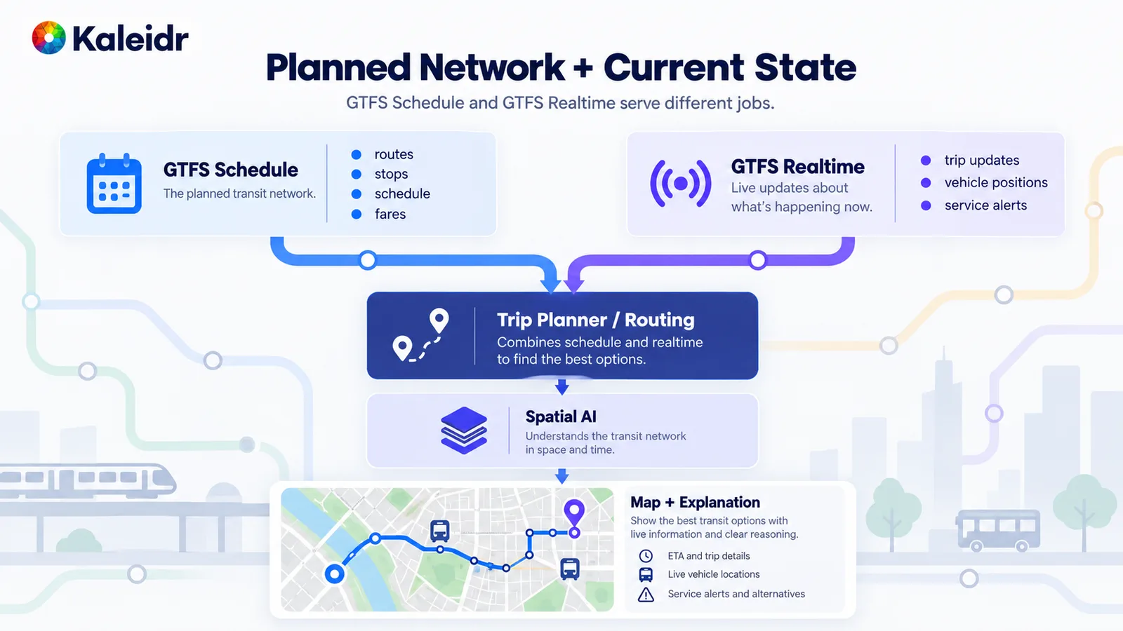
The schedule describes the planned network, including routes, stops, and trips. The realtime feed carries trip updates, vehicle positions, and service alerts. A trip planner combines those inputs, and the map explains the result. The diagram separates the two GTFS jobs, and the language model is not the routing engine.
The same split appears outside transit. A store's address is the schedule. Today's stock and today's closure are the realtime feed. A route calculation is a third service, with its own freshness. Do not ask a language model to rebuild a transit graph from raw feed files, and do not treat a vehicle position from this morning as proof of where the bus is now. Show the stop, the vehicle, and the alert as separate layers when the product needs the rider to tell them apart.
How Does a Sensor Stream Become a Place?
A raw sensor reading is not yet a map location. Devices, vehicles, and sensors can publish through MQTT or another telemetry API. OASIS describes MQTT Version 5.0 as a lightweight publish/subscribe protocol suited to machine-to-machine and Internet of Things communication (OASIS, 2019). The OGC SensorThings API standard is a geospatial way to interconnect IoT devices, data, and applications over the web, with sensing and tasking as its two main functions (OGC, 2026). After ingest, validate the schema, normalize the record, and store current state with an observation time and a freshness age. Only then does a spatial layer place the asset. The AI layer, the map, and operations read that state. They should not subscribe to the raw firehose.
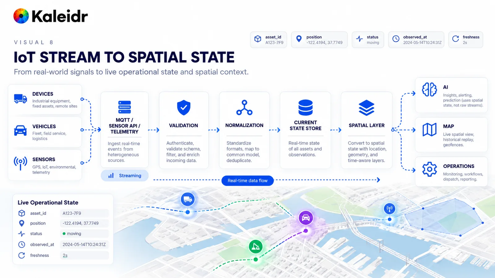
Telemetry becomes a current operational record with an asset identifier, a position, a status, an observation time, and a freshness age. The sample coordinates and the 2024 timestamp on the figure are illustration. Validation and normalization sit before the spatial layer. AI, the map, and operations read state, not the unfiltered stream.
A temperature without an asset and a threshold is not an answer. The question "which cold-storage site is above its limit" needs the sensor, the facility, the rule, and the time. Keep historical analytics on a different path from the current-state store when the volumes differ. Add backpressure so a burst of readings cannot stall the map. A disconnected sensor should surface as unknown, not as a quiet zero.
Why Is a Recommendation Not a Transaction?
A spatial recommendation can name a place. The host booking system still checks availability, price, and permission, confirms the request, and records the transaction. That boundary matters when two people can select the same room or the same pickup slot. The location-aware booking guide keeps the choice tied to live inventory, travel context, and eligibility (Kaleidr, 2026). The sample place identifier and transaction identifier on the figure are labels for that handoff, not a live Kaleidr booking. Kaleidr can show the confirmed result on the map after the host system returns it. Kaleidr does not become the ledger because the pin moved.
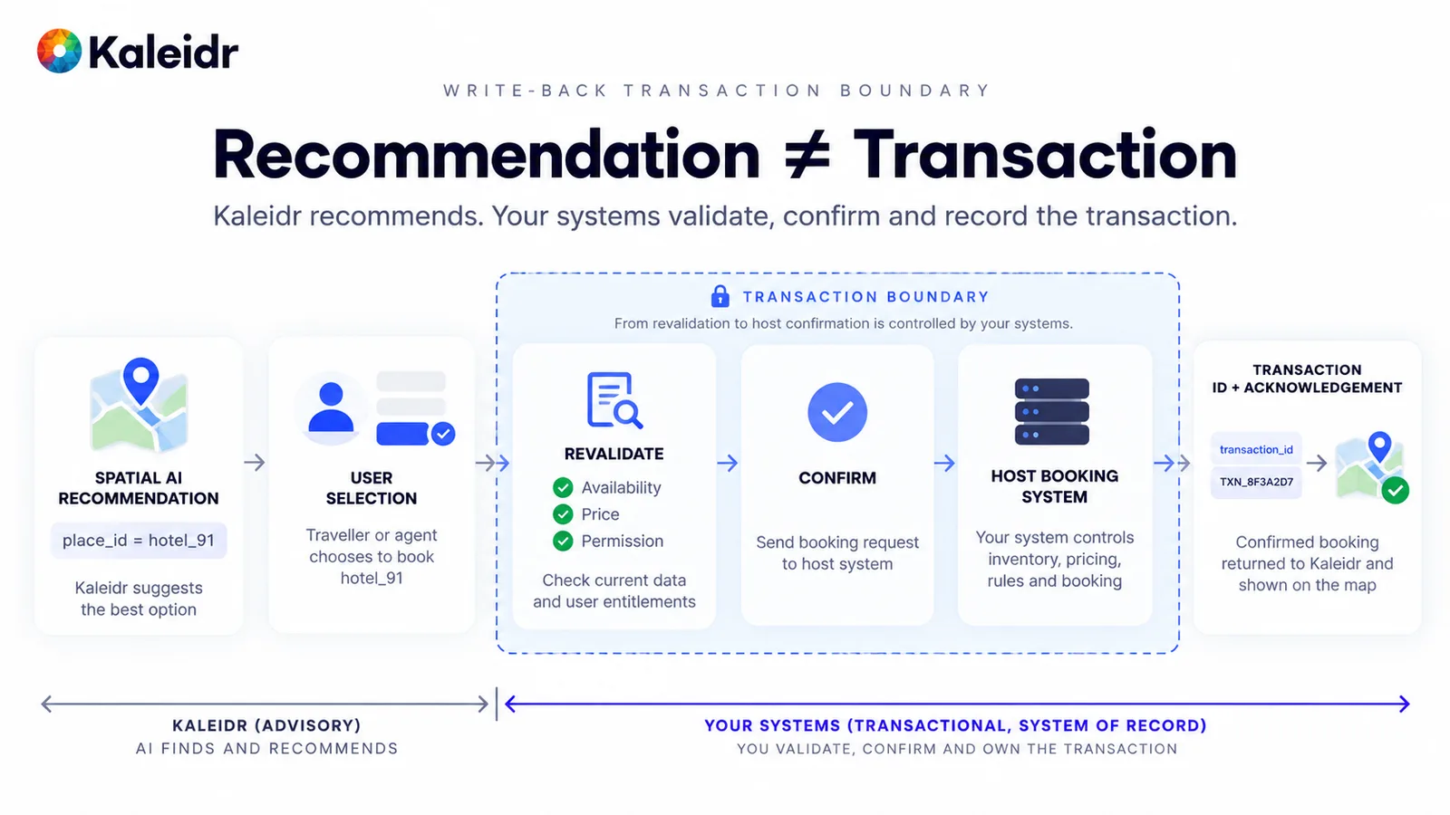
The left side finds and recommends a place. The transaction boundary revalidates availability, price, and permission, then confirms in the host system. A sample transaction identifier returns for the map to show. The identifiers on the figure are illustrative, and the host system remains the system of record.
Write the same rule for any action that changes money, inventory, or a person's rights. Revalidate immediately before the write, because the lookup that supported the explanation may already be stale. Return the host's acknowledgement, including a conflict, so the map does not show a success the ledger refused. A prompt line such as "never book without permission" can guide behavior. That sentence is not the transaction boundary.
Why Must Permission Come Before the Join?
The ability to join data is not permission to use it. An authorized flow resolves the user, the tenant, the object, and the field, then joins only the records and layers that survive those checks, and only then builds context for the explanation. A blocked path joins every private record first and hopes the model will hide the ones the user should not see. The join has already used unauthorized data. The private-location guide puts tenant, object, and field checks before private records reach a spatial calculation or a map answer (Kaleidr, 2026).
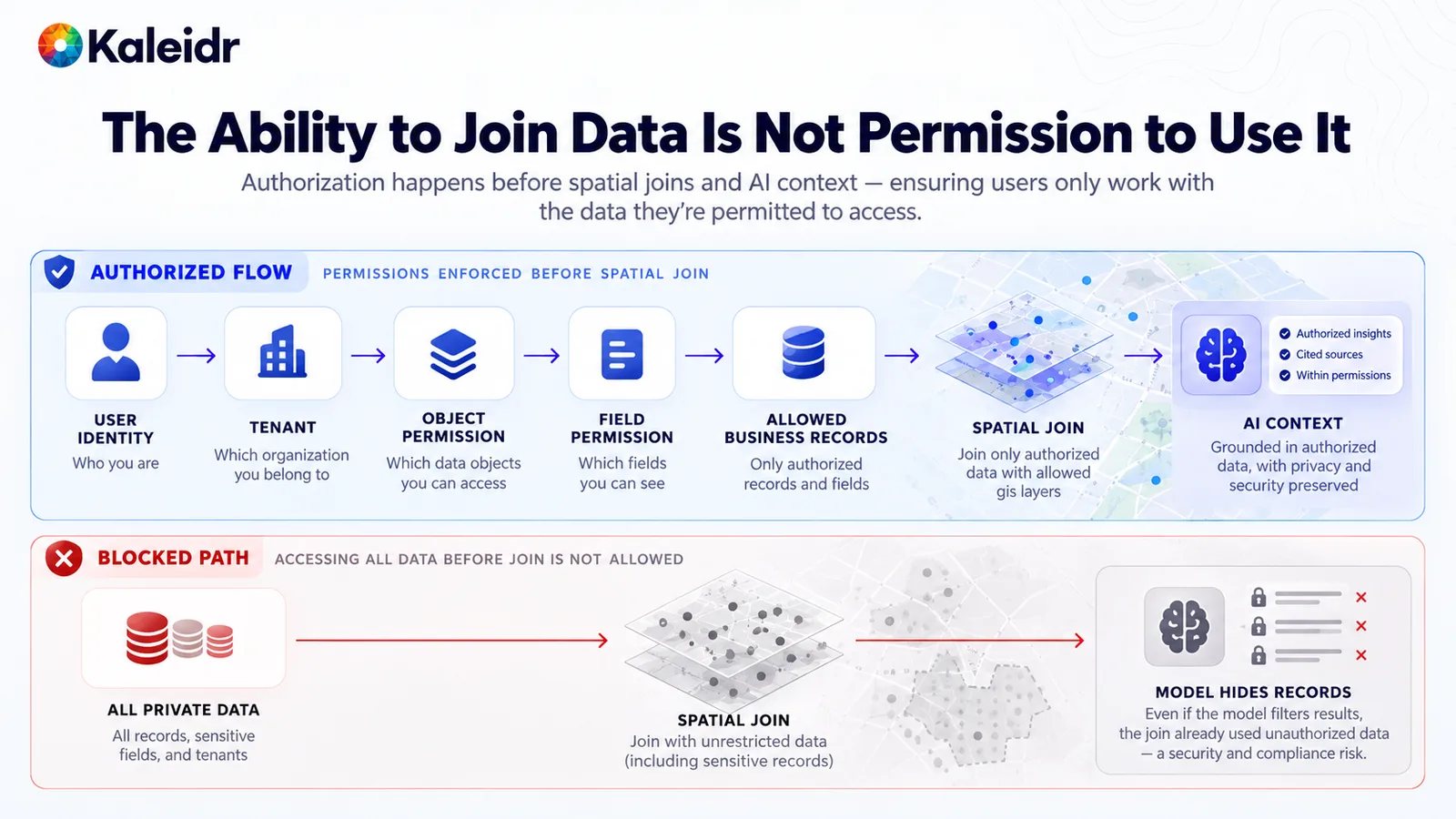
The upper path filters identity, tenant, objects, and fields before the spatial join and the explanation. The lower path joins every private record and only then tries to hide rows. A filter inside the answer cannot undo a join that already read the forbidden records. Permission is a precondition, not a caption on the result.
Preserve that permission context across every hop. A cache, a retrieval index, and a map layer can each become a second copy of a private field. Partition them by tenant, and drop fields the user cannot see before the copy is written. Cross-tenant retrieval is a data-integration bug even when the final sentence looks harmless. Log the identifiers and the policy result, not the private payload.
What Does the Production Path Look Like?
A production request can move through a stable sequence even when a given question skips a stage. The host application authenticates the user. Candidate sources supply snapshots, a spatial feature API, or CRM context. Live enrichment adds inventory, booking state, or operational status. Spatial services compute route, distance, and service area. Eligibility removes invalid candidates, and ranking orders what remains. The AI layer interprets the request and explains the grounded result. The map shows the place or the route. Validated write-back returns to the system of record when the user acts. Observability records identifiers, source, freshness, versions, and outcome along that rail (Kaleidr, 2026). A public attraction search may stop before private data and write-back. An inventory-aware pickup may need nearly every stage.
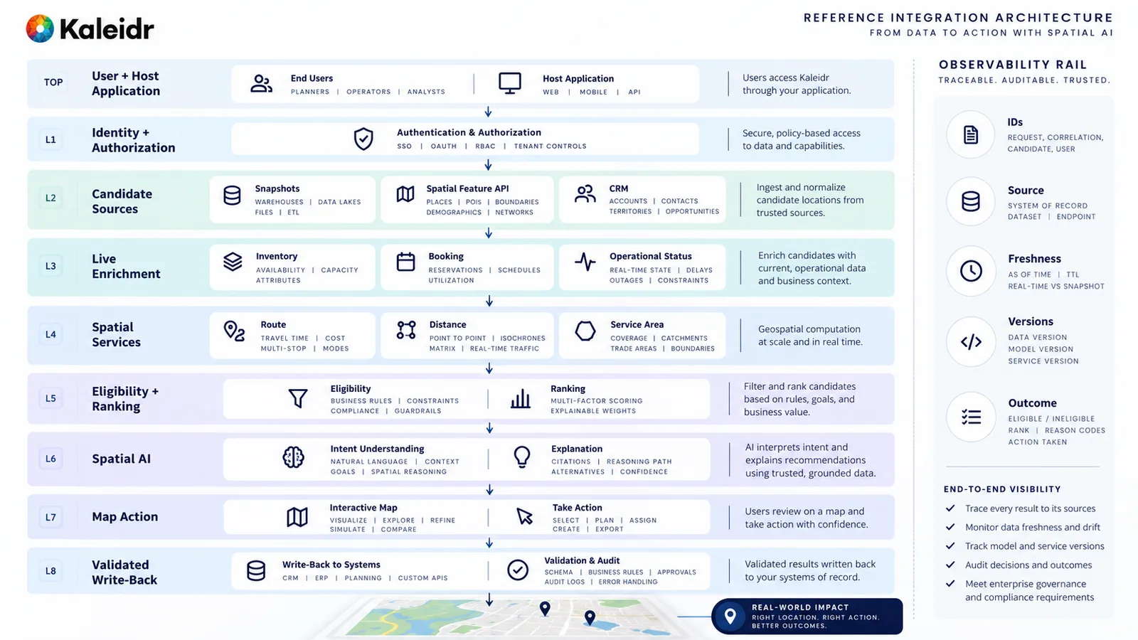
The stack runs from the host user down through authorization, candidates, live enrichment, spatial services, eligibility, explanation, the map, and write-back. An observability rail records identifiers, source, freshness, versions, and outcome. Not every request uses every layer. The diagram is a reference path, not a claim that one deployment must turn all of it on.
Test the integration with production-shaped failures, not only with a polished sentence. A missing inventory response, a disconnected sensor, a booking conflict, and a schema change should each have an error meaning and a map behavior. Separate current state from historical analytics so a dashboard query cannot stall the live picture. Version the schema and the transformation, because a renamed field should not silently become a new store.
Where Does Kaleidr Fit This Stack?
Kaleidr Enterprise is described on its product page as location-intelligence infrastructure with inference APIs, ranking systems, and analytics for spatial products (Kaleidr, 2026). The developer docs describe four surfaces on one platform: Chat is Spatial AI in the host's map, Editor is draw and edit, Tile serves designed basemaps, and Viewer publishes a map (Kaleidr, 2026). The public Platform API documents chat, route, POI enrichment, and design calls. That page does not document a universal connector for CRM, inventory, booking, GTFS, MQTT, or an enterprise database (Kaleidr, 2026). The host keeps those systems, the authorization of its users, and the transaction.
A practical split puts authorized, already-normalized context in front of the spatial layer. The host inventory API stays authoritative, the host checks permission, and Chat explains a recommendation on a map the product already runs. For a live operational picture, the operational system remains the source of current state while Studio authors the branded spatial presentation (Kaleidr, 2026). Confirm the Enterprise contract in the current docs before building against an endpoint the public API does not list. Explore Kaleidr Enterprise when the evaluation needs that spatial layer beside the systems the organization already operates.
Note: Kaleidr uses AI-assisted tools for image creation, content refinement, and research throughout its creative and development workflows.
FAQs
Does spatial AI data integration mean one connector for every system?
No. CRM, inventory, booking, transit, and IoT change at different speeds and carry different risk. Batch, live lookup, events, streams, spatial feature APIs, and validated write-back are separate patterns. A connector diagram that hides the system of record has not finished the design.
Can a language model replace the booking or inventory system?
No. The language model can interpret a request and explain a grounded result. Stock, availability, price, and the transaction stay in the systems that own them. Revalidate immediately before a write-back, and show the host's acknowledgement on the map.
Should GTFS Schedule and GTFS Realtime share one field?
No. GTFS Schedule is static public transportation information, including stops, routes, and trips. GTFS Realtime covers trip updates, vehicle positions, and service alerts. A trip planner can combine them. Collapsing both into one transit blob hides whether the rider is seeing the plan or the disruption.
Is a sensor reading already a map location?
No. A reading needs an asset, a validated position, an observation time, and a freshness age before it belongs on a spatial layer. MQTT can carry the message, and a SensorThings-style model can describe the sensing relationship. The map and the explanation should read current state, not the raw stream.
Does Kaleidr replace the CRM, inventory, or booking system?
No. Public docs describe Chat, Editor, Tile, Viewer, and Platform API calls for chat, route, POI enrichment, and design. They do not document a universal connector for CRM, inventory, booking, GTFS, or MQTT. The host keeps those systems and the transaction. Kaleidr supplies selected spatial and map capabilities beside them.
References
- Open Geospatial Consortium. OGC API - Features. A geospatial API for feature data. Accessed October 3, 2026. https://ogcapi.ogc.org/features/
- CloudEvents. CloudEvents. A specification for describing event data in a common way. Accessed October 3, 2026. https://cloudevents.io/
- General Transit Feed Specification. GTFS Overview. GTFS Schedule is a common format for static public transportation information, including stops, routes, and trips. Accessed October 3, 2026. https://gtfs.org/documentation/overview/
- General Transit Feed Specification. GTFS Realtime Reference. Trip updates, vehicle positions, and service alerts. Accessed October 3, 2026. https://gtfs.org/documentation/realtime/reference/
- OASIS. MQTT Version 5.0. A lightweight publish/subscribe protocol for machine-to-machine and Internet of Things communication. Accessed October 3, 2026. https://www.oasis-open.org/standard/mqtt-v5-0-os/
- Open Geospatial Consortium. OGC SensorThings API Standard. A geospatial way to interconnect IoT devices, data, and applications over the web, with sensing and tasking. Accessed October 3, 2026. https://www.ogc.org/standards/sensorthings/
- Kaleidr. Location-Aware Booking. https://kaleidr.com/blog/location-aware-booking
- Kaleidr. Private Location Data for AI Map Workflows. https://kaleidr.com/blog/private-location-data-for-ai-map-workflows
- Kaleidr. Spatial AI Observability. https://kaleidr.com/blog/spatial-ai-observability
- Kaleidr. Location Intelligence APIs and Map SDK. Inference APIs, ranking systems, and analytics for spatial products. Accessed October 3, 2026. https://kaleidr.com/enterprise
- Kaleidr Developer Docs. Products. Chat is Spatial AI in the host map, Editor is draw and edit, Tile is designed basemaps, and Viewer publishes a map. Accessed October 3, 2026. https://docs.kaleidr.com/
- Kaleidr Developer Docs. Platform API Endpoints. Documents chat, route, POI enrichment, and design calls, and does not document a CRM, inventory, booking, GTFS, or MQTT connector. Accessed October 3, 2026. https://docs.kaleidr.com/platform-api/endpoints
- Kaleidr. Real-Time Maps in Kaleidr Studio. Studio authors the spatial presentation, and the operational system remains the source of current state. https://kaleidr.com/blog/real-time-maps-in-kaleidr-studio
@misc{ogc_api_features_2026,
  title  = {OGC API - Features},
  author = {{Open Geospatial Consortium}},
  year   = {2026},
  url    = {https://ogcapi.ogc.org/features/}
}

@misc{cloudevents_2026,
  title  = {CloudEvents},
  author = {{CloudEvents}},
  year   = {2026},
  url    = {https://cloudevents.io/}
}

@misc{gtfs_overview_2026,
  title  = {GTFS Overview},
  author = {{General Transit Feed Specification}},
  year   = {2026},
  url    = {https://gtfs.org/documentation/overview/}
}

@misc{gtfs_realtime_2026,
  title  = {GTFS Realtime Reference},
  author = {{General Transit Feed Specification}},
  year   = {2026},
  url    = {https://gtfs.org/documentation/realtime/reference/}
}

@misc{oasis_mqtt_5_2019,
  title  = {MQTT Version 5.0},
  author = {{OASIS}},
  year   = {2019},
  url    = {https://www.oasis-open.org/standard/mqtt-v5-0-os/}
}

@misc{ogc_sensorthings_2026,
  title  = {OGC SensorThings API Standard},
  author = {{Open Geospatial Consortium}},
  year   = {2026},
  url    = {https://www.ogc.org/standards/sensorthings/}
}

@misc{kaleidr_booking_integration_2026,
  title  = {Location-Aware Booking},
  author = {{Kaleidr}},
  year   = {2026},
  url    = {https://kaleidr.com/blog/location-aware-booking}
}

@misc{kaleidr_private_location_integration_2026,
  title  = {Private Location Data for AI Map Workflows},
  author = {{Kaleidr}},
  year   = {2026},
  url    = {https://kaleidr.com/blog/private-location-data-for-ai-map-workflows}
}

@misc{kaleidr_observability_integration_2026,
  title  = {Spatial AI Observability},
  author = {{Kaleidr}},
  year   = {2026},
  url    = {https://kaleidr.com/blog/spatial-ai-observability}
}

@misc{kaleidr_enterprise_integration_2026,
  title  = {Location Intelligence APIs and Map SDK},
  author = {{Kaleidr}},
  year   = {2026},
  url    = {https://kaleidr.com/enterprise}
}

@misc{kaleidr_docs_home_integration_2026,
  title  = {Kaleidr Developer Docs},
  author = {{Kaleidr}},
  year   = {2026},
  url    = {https://docs.kaleidr.com/}
}

@misc{kaleidr_docs_endpoints_2026,
  title  = {Platform API Endpoints},
  author = {{Kaleidr}},
  year   = {2026},
  url    = {https://docs.kaleidr.com/platform-api/endpoints}
}

@misc{kaleidr_realtime_maps_integration_2026,
  title  = {Real-Time Maps in Kaleidr Studio},
  author = {{Kaleidr}},
  year   = {2026},
  url    = {https://kaleidr.com/blog/real-time-maps-in-kaleidr-studio}
}