
An AI campus map connects trusted university buildings, services, events, and accessibility data with an interactive map and a conversational Spatial AI layer. Students and visitors can ask where financial aid is or which library is closest to a next class. The language model interprets the request, campus systems remain authoritative for locations and hours, geospatial services calculate walking relationships, and the map returns a grounded campus action.
The sections below separate campus places from services and events, then cover architecture, visitor and student tasks, Kaleidr's public mapping, privacy and accessibility, evaluation, and a narrow pilot. Related reading includes AI Wayfinding Assistant for Venues, Grounded Spatial AI for Business Data, How to Build a Map-Aware AI Assistant, and AI Venue Map for Events. The rest of the article is written for university product and IT teams that already own a campus map or student-facing application, not for teams shopping for a replacement student-information system.
AI campus map essentials
- Places first: Canonical building and campus IDs beat display names.
- Owners stay split: Facilities, services, events, parking, and accessibility do not share one system of record.
- Ground then explain: The language model is not the campus directory.
- Public stays public: Student-specific context belongs on an authenticated surface.
- Measure the task: Destination resolved, service opened, and no-result geography beat chat length.
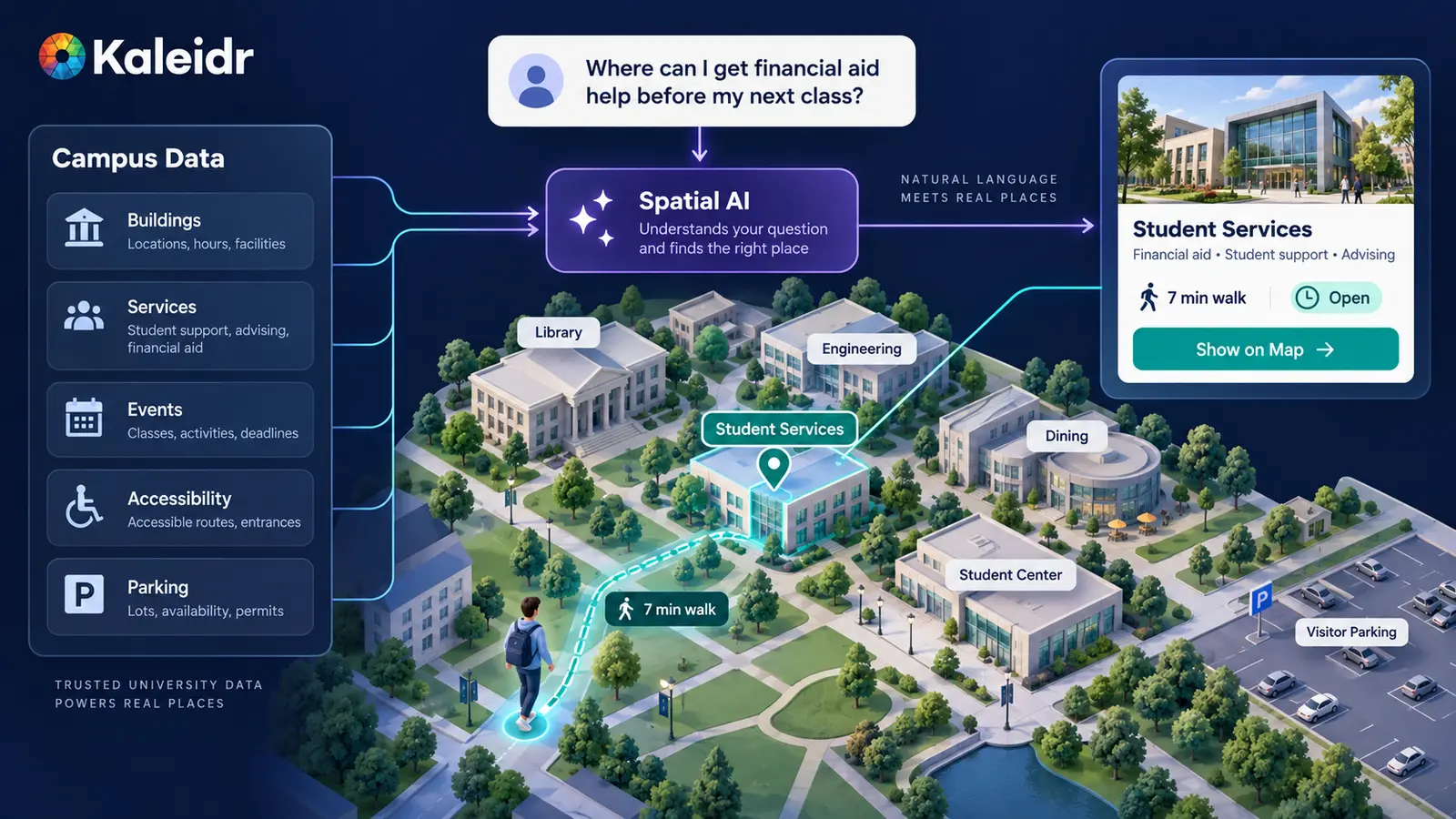
A useful AI campus map interprets the question while university systems remain authoritative for the campus facts.
Why Is an AI Campus Map a University Architecture Problem?
A generic local-search assistant can list a named building around a pin. A university product has to answer which office currently handles financial aid, which entrance is verified as accessible, which visitor lot still serves admissions, or which event after 4 p.m. sits near the student center. Those answers depend on canonical place identity, departmental ownership, hours, eligibility, and operational state. A language model should not invent those fields from training memory.
Kaleidr currently positions Education as a Spatial AI vertical on the homepage (Kaleidr, 2026). Tyton Partners' Time for Class 2026: The AI Tipping Point surveyed more than 3,000 students, instructors, and administrators across over 750 U.S. colleges and universities in April and May 2026. The report frames the sector as choosing between AI integration and restriction, and states that institutions treating AI as part of the learning experience are seeing measurably better student engagement (Tyton Partners, 2026). That finding does not imply every campus interface should become a conversational layer. Natural-language interaction is familiar enough in higher education to be one useful interface for compound campus questions, alongside search, filters, and the map.
The product opportunity is therefore not a second unofficial campus directory. Location, campus state, and student or visitor intent still have to reduce friction without replacing the systems that already own buildings, services, events, and student records. Search, filters, and conversation can share that same grounded place model instead of competing with it.
What Campus Data Should Ground Spatial AI?
The foundation is the campus place model, not the language model. A university can define stable entities such as campus, building, entrance, department, office, classroom, library, dining location, parking area, transit stop, student service, athletic facility, and event venue. A service or event then points at a place ID rather than at a free-text building name. Stable identifiers allow the map, website, AI explanation, and analytics to refer to the same location after a rename, a donor plaque, or a student nickname.
Universities routinely carry abbreviations, historic names, and multi-campus collisions. "ENG," "Engineering," and "New Engineering Hall" may all need to resolve to one place ID. Aliases are search data. The ID is identity. Without that split, a follow-up such as "what is near this building?" cannot keep the selected place in context, and How to Build a Map-Aware AI Assistant treats that shared map state as load-bearing rather than decorative.
Source ownership should stay inspectable. Facilities or the campus map system can own buildings, entrances, paths, and parking geography. A department directory can own office purpose, service location, and hours where the department maintains them. An event system can own title, time, registration, and status. Transit or mobility sources can own shuttle facts where the institution supports them. An accessibility source can own verified entrances and approved path information. The AI layer owns request interpretation, clarification, explanation, and supported map actions. Grounded Spatial AI for Business Data sets the same boundary for authorized business inventory: the model explains grounded records; it does not become the system of record.
The following comparison is editorial, not a documented Kaleidr campus schema. Real deployments should fill the same columns from the systems the host already runs. The table names the owner a reviewer should inspect when a recommendation is wrong.
| Claim | Authoritative source |
|---|---|
| Building exists at these coordinates | Campus facilities / map system |
| Financial aid currently sits in this room | Department or service directory |
| Event starts at 3 p.m. in the library | Event system |
| Visitor lot still serves admissions | Parking system |
| East entrance is the verified accessible entrance | Accessibility source |
| Walking time from the library | Routing or distance service |
| Why this destination ranked first | AI explanation of the above |
Why Must Places, Services, and Events Stay Separate?
Do not flatten every campus record into a pin. A building is a place. A service is an organizational function that may operate at a place. An event is a time-bound activity at a place. The library, a writing center inside it, and a Tuesday resume workshop at the same address are related entities, not interchangeable markers. Keeping those identities separate makes follow-up questions possible: the workshop can move rooms without renaming the library, and the writing center can keep hours that the building itself does not share.
Students often ask for services rather than buildings. "Where is tutoring?" and "Where do I get my student ID?" require service intent, then a university service record, then a physical destination. A public map provider may know the student center exists. The provider may not know which office inside it currently handles a specific university workflow. That gap is first-party campus knowledge, and a production product should retrieve it from authorized campus data rather than from generic web search.
Operational state needs an owner and an expiration policy. Path closures, office relocations, construction, and seasonal entrance changes go stale quickly. A temporary east-entrance closure that outlives the construction window is worse than omitting the field. Include only attributes the institution can keep current.
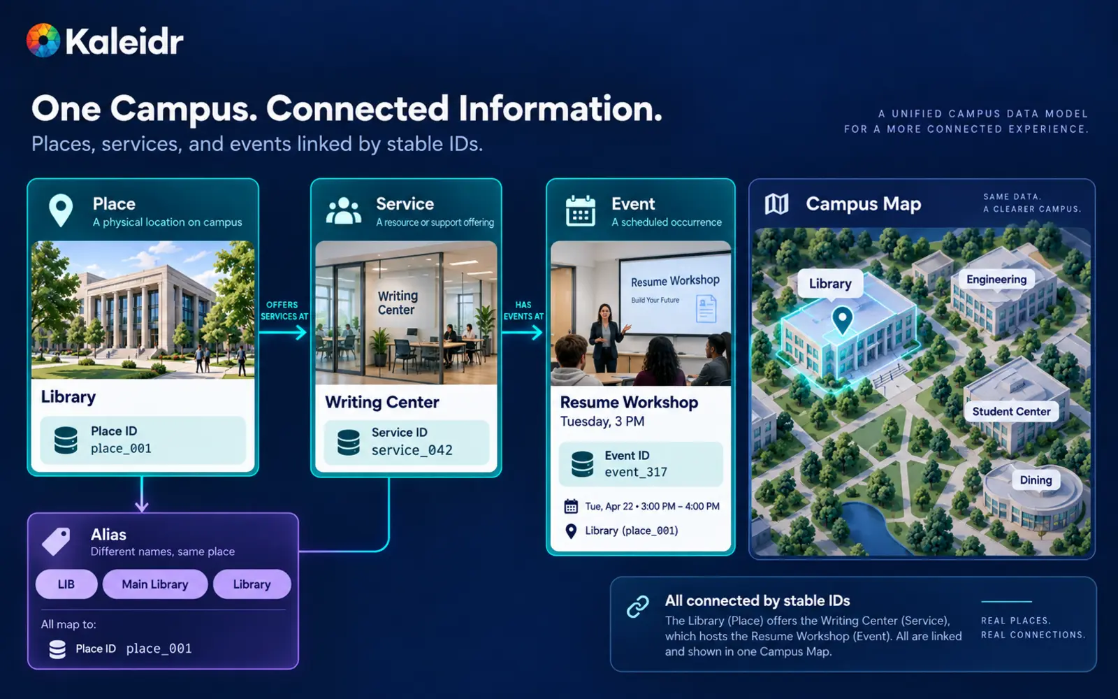
Buildings, services, and events are related campus entities—not interchangeable map pins.
How Should an AI Campus Map Be Architected?
A production sequence can run as student or visitor question, intent interpretation, campus context, authorized campus data, entity resolution, eligibility or open-state rules, spatial calculation, grounded explanation, validated map action, then a university-owned next step. The order is load-bearing. The language model should not receive every private student record and then be asked to guess a destination. Authorization belongs before retrieval, the same pattern Private Location Data for AI Map Workflows sets for other tenant-controlled records.
Start from the campus job rather than from a decorative map. Typical jobs include finding financial aid before the next class, ordering admissions, engineering, and dining into a walking visit, listing events near the student center after 4 p.m., or locating visitor parking for an athletic venue. Ordinary filters become cumbersome once several of those constraints appear in one sentence. The AI layer is useful when it names the question campus systems should answer, not when it invents hours or room numbers.
Keep direct search. Conversation helps for compound intent such as the closest visitor parking to admissions, dining between two buildings, or an accessible entrance for a selected place. Once a user selects a building, follow-up questions should resolve "this building" to the selected place ID, viewport, and active filters. Supported actions can include focusing a place, showing a shortlist, showing a route, highlighting an area, or opening a university service or event page. The host application validates each action. Avoid arbitrary JavaScript or unbounded map commands from the model.
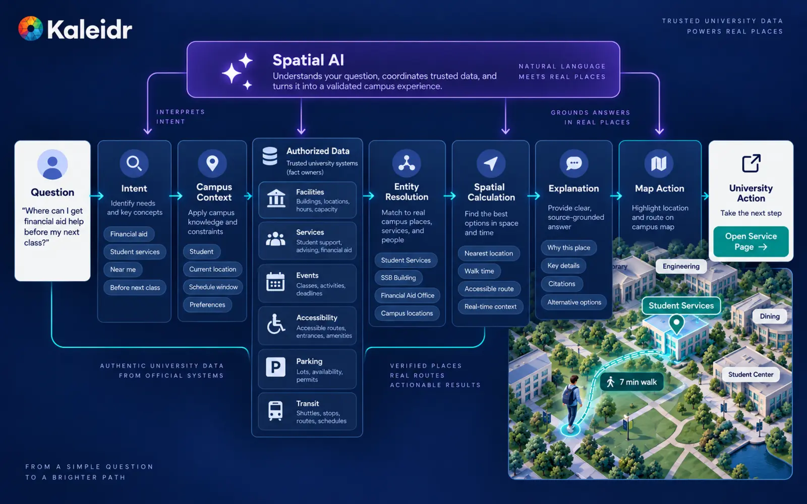
The model interprets and explains; campus systems provide facts and spatial services calculate the geographic relationship.
How Do Student and Visitor Tasks Differ From Directory Search?
A directory lists what exists. An AI campus map answers which currently usable destination fits the question, the origin, and the next stop. A student with a short window between classes is asking for a cafe that still returns in time, not for a complete dining catalog. The nearest cafe can be the wrong cafe if the walking path backtracks from the next classroom. Spatial context then ranks remaining eligible places after hours and open-state rules remove the rest.
Visitor journeys are often less vocabulary-fluent than student journeys. Applicants, families, alumni, conference guests, vendors, athletic-event attendees, and prospective employees may not know building abbreviations, parking names, or departmental organization. Natural-language search can make the campus legible without requiring institutional jargon. Admissions visit planning, new-student orientation, public event overlays, and multi-campus resolution are the same architecture applied to different approved destination sets. Spatial AI for Multi-Location Businesses covers the analogous site-resolution problem when one organization operates several campuses or properties.
Indoor turn-by-turn navigation is optional and separate. A strong first version can support building discovery, service discovery, event discovery, parking, outdoor walking relationships, and accessible entrances. AI Wayfinding Assistant for Venues already covers indoor routing and floor topology in detail. Do not make those capabilities a prerequisite for the education use case, and do not treat the campus article as a second wayfinding spec.
Campus maps should also stay out of neighboring academic products. The SIS may own enrollment, registration, and the student record. The LMS may own course content and the learning workflow. Next-class building and next-class start time can be enough schedule context for a map task. The map does not need grades, a full transcript, or advising history. Academic advising is broader than place discovery: the map can answer where advising sits; it should not automatically answer which courses to drop unless the university has built and governed that separate capability.
Where Does Kaleidr Fit in a Campus Stack?
The AI Map Chat for Customer Discovery page currently describes adding AI-powered search, recommendations, insights, and location-aware experiences to an existing map without rebuilding the host platform. The Chat attach page documents product="chat" as a conversational layer over a map the host already renders, with auto-detection for Mapbox, MapLibre, Google, and Leaflet maps, plotting resolved places and framing the camera as the conversation identifies locations (Kaleidr, 2026). The natural B2B pattern is an existing campus website or app, map, and institutional systems plus a Kaleidr conversational spatial layer, not a replacement of campus software.
The current public Platform API endpoints list includes SDK session exchange, streaming chat, route, POI enrichment, and design endpoints. The list does not currently publish dedicated student-information, learning-management, room-reservation, or campus-shuttle-feed routes. A university article should not imply that Kaleidr replaces the SIS, LMS, event platform, parking system, or facilities GIS. Those remain host integrations unless a supported enterprise deployment states otherwise. The Location Intelligence APIs and Map SDK page currently describes SDKs, ranking, and analytics for spatial products. Depending on the configuration, Kaleidr can support a branded public campus or visitor surface while authenticated student actions still require host authorization.
The AI Map Maker for Branded Interactive Maps page currently describes Studio as a map-authoring surface for custom interactive maps, layers, datasets, branded tiles, 3D visualization, live data layers, and publishing. For universities, Studio can support branded visitor maps, orientation overlays, and public destination layers. Use the host application and deeper integration where authenticated student context or complex operational systems are required. 3D Maps in Kaleidr Studio covers the visualization side without turning Studio into a student-record product.
How Should Universities Handle Privacy, Accessibility, and Emergencies?
Authenticate the user, determine which places and fields the role may see, retrieve only those records, and only then provide a compact context package to the AI layer. Public campus data can include building locations, public events, library hours, and public dining locations. Account-specific examples can include an individual class schedule, program, advising appointment, account status, or housing assignment. Do not send an entire student record into the model because one campus question needs one building destination.
In U.S. higher education, student-record workflows may be subject to the Family Educational Rights and Privacy Act (U.S. Department of Education, 2026). A campus AI product should distinguish public campus maps from education-record data. The host institution controls authentication, authorization, disclosure, retention, and legal review for student-specific data. This article describes the architectural split; it does not tell a university what is lawful for a specific deployment. That judgment belongs to qualified counsel.
Accessibility claims need verified data. If a student asks for a step-free route to the library, the product needs an accessibility source and a routing system that can support the claim. Relevant fields can include accessible entrances, elevators, ramps, path restrictions, and construction closures. If the route system cannot verify a fully accessible path, do not claim one. A safer response names the verified accessible entrance and states that a fully accessible route is not available from current routing data. Digital accessibility still applies to the map product itself: keyboard navigation, screen-reader alternatives, semantic place lists, contrast, text equivalents, and readable mobile controls. A visual map should not become the only way to retrieve campus information.
Emergency information is a separate boundary. Emergency alerts, evacuation instructions, shelter information, and public-safety actions should come from official university emergency systems. An AI map can display or link to approved emergency information if the institution supports that workflow. The language model should not improvise safety instructions.
How Should Teams Evaluate an AI Campus Map?
Kaleidr Analytics currently documents map and place engagement, place comparison, spatial patterns, and activity that product, inventory, and growth teams can act on (Kaleidr, 2026). Host systems still own events, parking, and student records. Use that loop to find services with high search demand and low successful resolution, visitor parking questions that repeat, buildings that generate navigation queries, and campus zones with no-result rates. Spatial Analytics vs. Web Analytics covers why pageviews alone cannot answer those questions. Suggested event names in this article are editorial recommendations, not documented automatic Kaleidr Analytics event names.
Useful outcome measures include destination resolved, service found, route opened, event opened, parking selected, visit action completed, and no-result reason. A one-message success is often ideal. Do not optimize for messages per session. Compare campuses only after place identity, hours, and walking context are held constant. Privacy in campus analytics means aggregate zones and task outcomes, not named student trails or continuous movement histories.
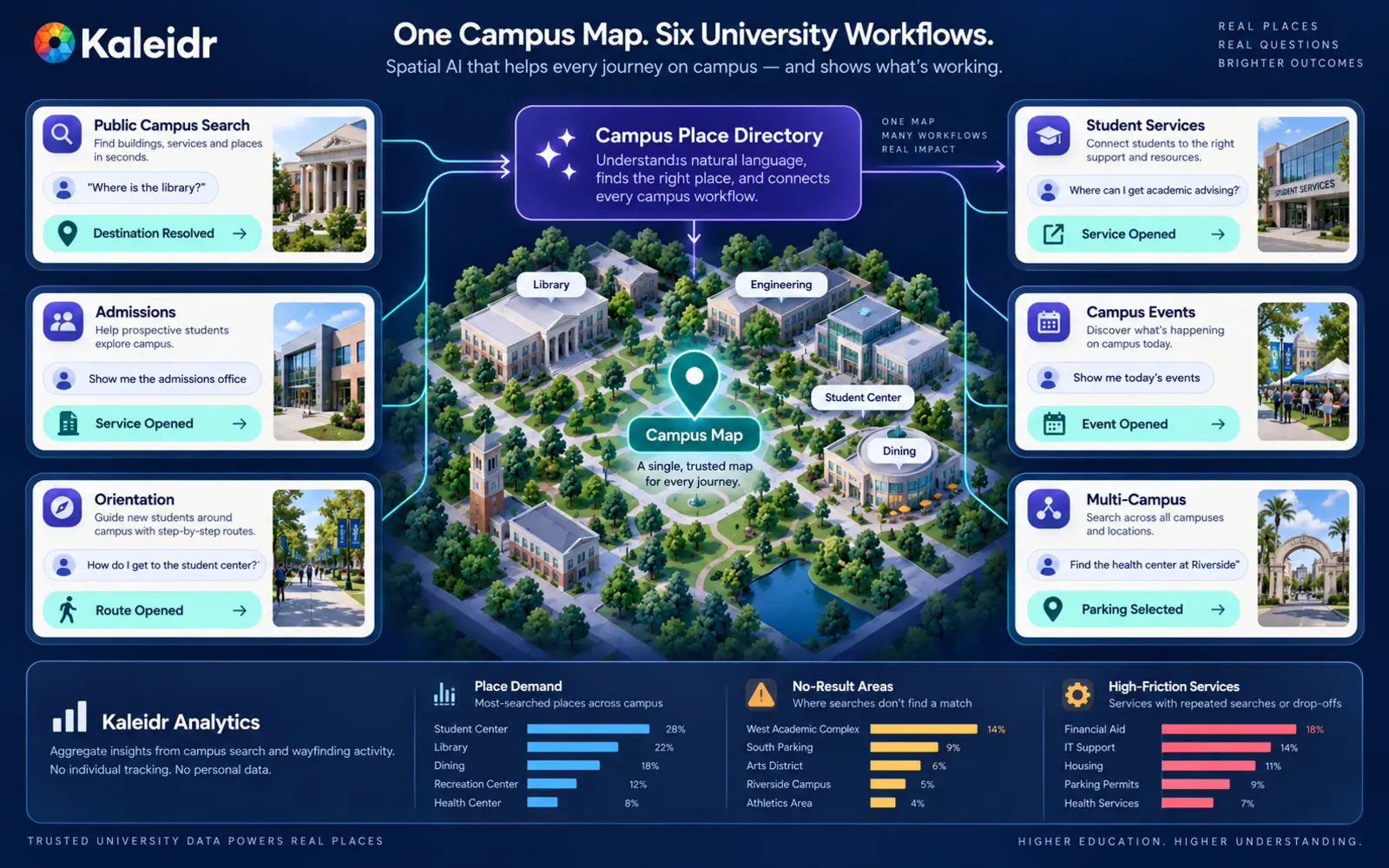
A campus Spatial AI layer can support multiple university journeys while measurement stays focused on place discovery and task completion rather than student surveillance.
How Should a University Pilot an AI Campus Map?
Start with one campus and one high-value task, such as helping new students and visitors find buildings and student services. Keep identity, hours, events, and student records in the systems that already own them. Attach conversational map interaction to the existing map. Limit candidates to authorized public or role-visible places, require current open state where the host can supply it, calculate walking relationship to a selected origin, and measure destination resolution plus the university action that follows. Expand events, parking, accessibility, and authenticated schedule context only when that first window works.
Conversational discovery does not replace content ownership, hours freshness, or emergency systems. Walking times remain estimates. Indoor positioning is optional. Attaching an assistant to an existing map is usually cheaper than replacing the renderer, but the host still has to own authorization and the next campus action. Treat missing data as unknown rather than as a pass, and roll out by campus rather than every site at once.
Explore Kaleidr Spatial AI to add conversational location search on an existing map. Explore Kaleidr Enterprise to attach SDKs and ranking to the stack you already operate. Explore Kaleidr Analytics to measure place engagement and geographic demand around that journey. Confirm the current public pages before treating any example in this article as a shipping contract.
FAQs
What is an AI campus map?
An AI campus map combines a university's trusted campus locations and services with an interactive map and natural-language interface so students and visitors can ask where to go, what is nearby, and what action to take next.
How is an AI campus map different from a campus chatbot?
A campus chatbot can answer text questions. An AI campus map shares place and map context so answers can resolve a destination, highlight it, show related places, or hand off to a route or university service.
Does an AI campus map replace a university's existing map?
Not necessarily. Kaleidr's current Chat documentation supports attaching AI to compatible existing Mapbox, Google Maps, MapLibre, or Leaflet maps, so a university can keep its current renderer and campus application.
What university data should ground the AI?
Useful sources include canonical buildings, campus services, departments, events, parking, approved accessibility information, hours, and operational updates. Each source should have a clear owner.
Can an AI campus map use a student's class schedule?
An AI campus map can use a class schedule if the institution intentionally builds an authenticated workflow and provides only the minimum authorized schedule context needed for the task. Student-specific data should be governed separately from public campus data.
Does Kaleidr replace the SIS or LMS?
No. The SIS and LMS should remain authoritative for student and academic records. The campus map should use only the specific data required for the spatial task.
Can AI provide accessible campus routes?
Only when the underlying accessibility and routing data can support the claim. The AI layer should not invent an accessible route from incomplete data.
Should emergency information come from AI?
No. Emergency instructions and alerts should remain authoritative in university public-safety and emergency systems. An AI map may surface approved information but should not improvise emergency guidance.
What is a good first campus AI use case?
A strong pilot is public building and student-service discovery: connect canonical locations and services, resolve common aliases, add walking context, and measure successful destination resolution.
Can Kaleidr Studio be used for a campus map?
Kaleidr Studio can support branded interactive map authoring, layers, datasets, 3D context, live overlays, and publishing. Deeper authenticated student workflows may require a custom host application and integration.
What should a university measure?
Measure destination-resolution rate, service-resolution rate, no-result reasons, route or detail opens, visitor parking selections, event actions, and aggregate place or search demand rather than chat volume alone.
Is this the same as indoor campus wayfinding?
No. Indoor wayfinding is one possible deeper capability. A campus Spatial AI experience can be valuable with building, service, event, parking, and outdoor navigation context before indoor positioning or floor-level routing exists.
References
- Kaleidr. AI-Powered Map Experiences for Business. Accessed 15 September 2026. https://kaleidr.com/
- Tyton Partners. Time for Class 2026: The AI Tipping Point: From Monitoring Students to Engaging Them. 12 June 2026. https://tytonpartners.com/time-for-class-2026-the-ai-tipping-point-from-monitoring-students-to-engaging-them/
- U.S. Department of Education. FERPA. Protecting Student Privacy. Accessed 15 September 2026. https://studentprivacy.ed.gov/ferpa
- Kaleidr. AI Map Chat for Customer Discovery. Accessed 15 September 2026. https://kaleidr.com/ai
- Kaleidr. Chat — attach AI to your map. Developer documentation. Accessed 15 September 2026. https://docs.kaleidr.com/sdk/chat-attach
- Kaleidr. Endpoints. Developer documentation. Accessed 15 September 2026. https://docs.kaleidr.com/platform-api/endpoints
- Kaleidr. Location Intelligence APIs and Map SDK. Accessed 15 September 2026. https://kaleidr.com/enterprise
- Kaleidr. AI Map Maker for Branded Interactive Maps. Accessed 15 September 2026. https://kaleidr.com/studio
- Kaleidr. Map Engagement and Location Analytics. Accessed 15 September 2026. https://kaleidr.com/analytics
- Kaleidr. AI Wayfinding Assistant for Venues. Accessed 15 September 2026. https://kaleidr.com/blog/ai-wayfinding-assistant
@misc{kaleidr_campus_home_2026,
  title  = {AI-Powered Map Experiences for Business},
  author = {{Kaleidr}},
  year   = {2026},
  note   = {Accessed 15 September 2026},
  url    = {https://kaleidr.com/}
}

@misc{tyton_time_for_class_2026,
  title  = {Time for Class 2026: The AI Tipping Point: From Monitoring Students to Engaging Them},
  author = {{Tyton Partners}},
  year   = {2026},
  month  = jun,
  note   = {Fielded April--May 2026; more than 3,000 students, instructors, and administrators across over 750 U.S. colleges and universities},
  url    = {https://tytonpartners.com/time-for-class-2026-the-ai-tipping-point-from-monitoring-students-to-engaging-them/}
}

@misc{ed_ferpa_2026,
  title  = {FERPA},
  author = {{U.S. Department of Education}},
  year   = {2026},
  note   = {Protecting Student Privacy; page states no publication year; access year used for the parenthetical; accessed 15 September 2026},
  url    = {https://studentprivacy.ed.gov/ferpa}
}

@misc{kaleidr_campus_ai_2026,
  title  = {AI Map Chat for Customer Discovery},
  author = {{Kaleidr}},
  year   = {2026},
  note   = {Accessed 15 September 2026},
  url    = {https://kaleidr.com/ai}
}

@misc{kaleidr_campus_chat_attach_2026,
  title  = {Chat -- attach AI to your map},
  author = {{Kaleidr}},
  year   = {2026},
  note   = {Developer documentation; accessed 15 September 2026},
  url    = {https://docs.kaleidr.com/sdk/chat-attach}
}

@misc{kaleidr_campus_endpoints_2026,
  title  = {Endpoints},
  author = {{Kaleidr}},
  year   = {2026},
  note   = {Developer documentation; accessed 15 September 2026},
  url    = {https://docs.kaleidr.com/platform-api/endpoints}
}

@misc{kaleidr_campus_enterprise_2026,
  title  = {Location Intelligence APIs and Map SDK},
  author = {{Kaleidr}},
  year   = {2026},
  note   = {Accessed 15 September 2026},
  url    = {https://kaleidr.com/enterprise}
}

@misc{kaleidr_campus_studio_2026,
  title  = {AI Map Maker for Branded Interactive Maps},
  author = {{Kaleidr}},
  year   = {2026},
  note   = {Accessed 15 September 2026},
  url    = {https://kaleidr.com/studio}
}

@misc{kaleidr_campus_analytics_2026,
  title  = {Map Engagement and Location Analytics},
  author = {{Kaleidr}},
  year   = {2026},
  note   = {Accessed 15 September 2026},
  url    = {https://kaleidr.com/analytics}
}

@misc{kaleidr_campus_wayfinding_2026,
  title  = {AI Wayfinding Assistant for Venues},
  author = {{Kaleidr}},
  year   = {2026},
  note   = {Accessed 15 September 2026},
  url    = {https://kaleidr.com/blog/ai-wayfinding-assistant}
}