
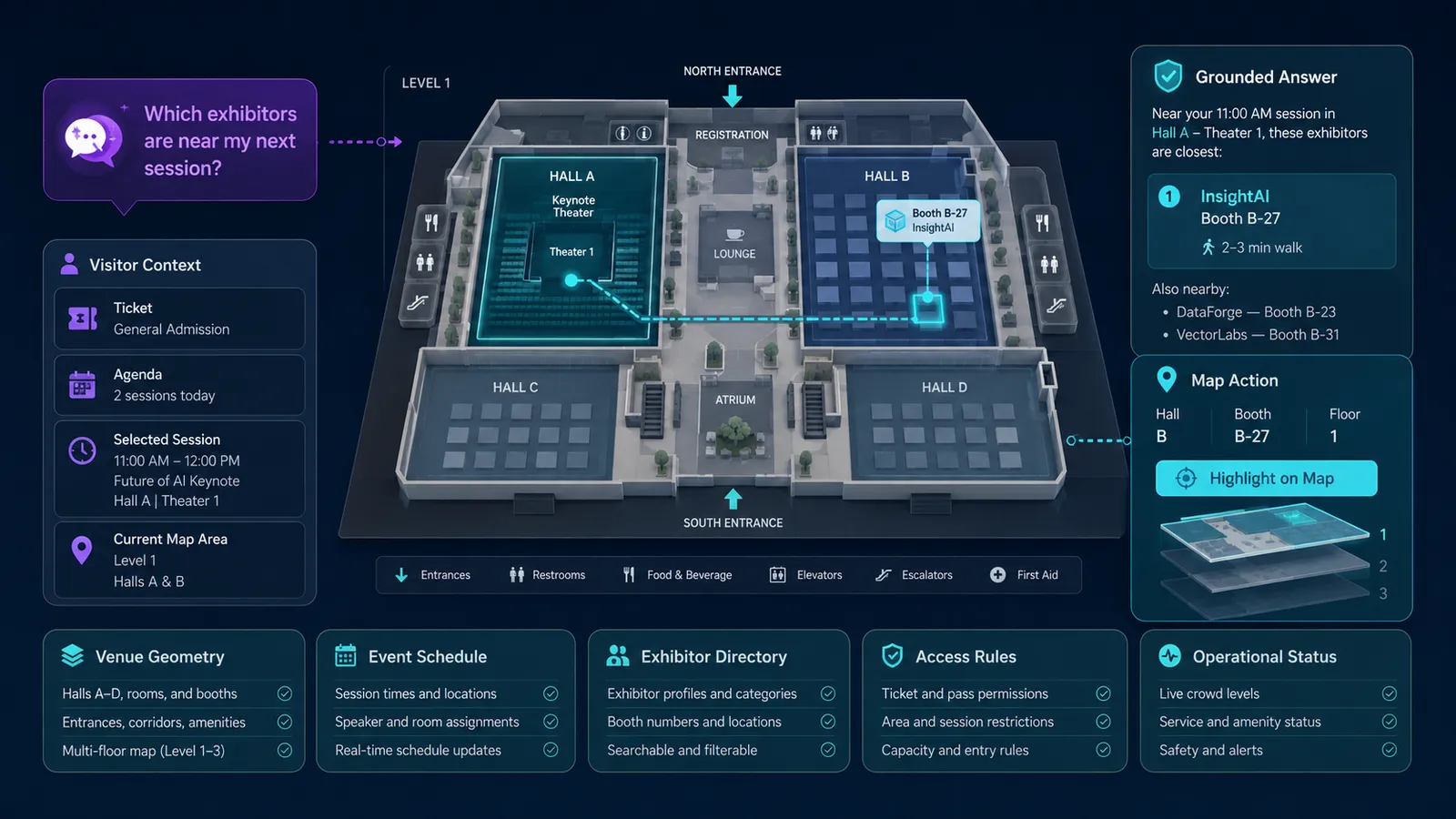
An AI venue map combines an interactive map with venue geometry, event content, and visitor context so attendees can ask where a room is or which exhibitors sit near the next session, and receive a grounded answer plus a visible map action. The venue system remains authoritative for rooms, schedules, exhibitors, access rules, and operational status. A language model interprets intent; spatial systems calculate routes only where the deployment supports them.
The sections below cover data layers, stable identifiers, indoor navigation limits, shared state, access and accessibility, Kaleidr’s current fit, measurement, and failure modes. Related reading includes Location Intelligence Customer Experience Maps, How to Build a Map-Aware AI Assistant, AI Guest Concierge for Hotels, and Location-Aware Booking.
AI venue map essentials
- Authoritative records first: Rooms, booths, sessions, and access rules come from venue and event systems, not generated prose.
- Geometry, event overlay, live operations: Keep the building stable, the event replaceable, and closures current.
- Place lookup is not indoor routing: Highlighting Room 204 is not the same as computing a turn-by-turn path.
- The language model interprets intent: Geospatial and venue systems calculate location; the host validates map actions.
- Direct search must still work: A visitor who types
Hall Bshould not need a conversation.
What Is an AI Venue Map?
An AI venue map is a customer-facing guide in which geography, event content, and conversation share one state. A static floor plan answers where something sits. A directory answers what it is called. Neither answers which place is relevant to this visitor right now. Conference, stadium, campus, festival, and museum visits combine a ticket, a schedule, a current floor or map area, and a next destination. The useful product keeps those facts inspectable on the map rather than leaving the visitor to reconstruct them from signage, PDFs, and a chat panel that cannot move the camera.
Kaleidr’s current homepage lists Events & Venues among AI-driven customer journeys (AI-Powered Map Experiences for Business). That page is authoritative about Kaleidr’s own positioning. The architecture below is a product contract for hosts: the language model interprets the request; venue geometry, event systems, and access rules remain the sources of truth.
A useful test is a compound question. “Which cybersecurity exhibitors are near my 2 PM session, on this floor, and still open?” encodes a category, a schedule constraint, a floor, and operating status. The language model can recover those fields as inspectable constraints. Booth assignment, session time, and the right to see a restricted hall still have to come from systems that own those facts.
Why Are Venues a Spatial Information Problem?
Large venues contain more information than one drawing can communicate at once. A visitor may need an entrance, gate, hall, room, stage, exhibitor, booth, restaurant, restroom, elevator, accessible route, parking area, rideshare zone, charging point, information desk, or first-aid station. The same visitor may also hold a ticket type, a saved agenda, an accessibility requirement, a current map view, or a next session. That combination turns the map into a decision interface rather than a poster of the building.
Customer-facing location intelligence uses the same Discover → Compare → Act shape. Discover retrieves eligible spaces and event records. Compare makes floor, travel relationship, schedule fit, and access inspectable. Act is a highlight, a floor switch, a saved exhibitor, directions where routing exists, or a staff handoff. The business outcome is that the visitor reaches the right place in time, not that a marker was tapped.
Ordinary city maps hide a second problem indoor venues create: floor. A selected place is often Building A, Floor 2, Room 204. If the assistant says the room is directly above the visitor, the product needs a real cross-floor model before making that claim. Tracking buildingId, floorId, and selectedSpaceId as shared state is the minimum. Guessing vertical adjacency from a picture of a floor plate is not a model.
Which Data Layers Should an AI Venue Map Combine?
A useful venue experience usually combines four layers, and the language model should not collapse them into one generated paragraph. Venue geometry covers buildings, floors, halls, rooms, corridors, entrances, outdoor zones, and parking. Event content covers sessions, exhibitors, booths, attractions, stages, restaurants, and temporary installations. Operational state covers open or closed entrances, room changes, elevator status, event hours, and schedule updates. Visitor context covers ticket, saved agenda, selected session, language, current map view, and origin when the host has permission to use it.
| Question | Authoritative source |
|---|---|
| Where is the space? | Venue geometry |
| Who occupies the booth this week? | Event / exhibitor directory |
| When does the session start? | Schedule system |
| Is the entrance open? | Operational status |
| May this visitor enter? | Ticket / access rules |
| What did the visitor ask? | Language-model intent layer |
| What happened after guidance? | Analytics |
Do not use display names as the only identity. Room 204, Booth 204, and Session 204 collide in human language. A stable space record can carry id, type, name, floor, and geometryId. An exhibitor record should point at a booth identifier, and a session record should point at a room identifier. Map, schedule, search, conversation, and analytics can then stay synchronized when labels change between events.
{
  "id": "space_hall_b_204",
  "type": "room",
  "name": "Room 204",
  "floor": 2,
  "geometryId": "geom_204"
}
Why Should Venue Geometry Stay Separate From Event Content?
The building may be stable for years. The event changes every few days. Hall B can exist all year while Booth 7A maps to a different exhibitor at every show. Mixing both into one permanent geometry file makes reuse painful: the next event has to rebuild walls in order to move a carpet. Separate models keep a reusable venue layer and a replaceable event overlay, then compose them into the map the visitor sees.
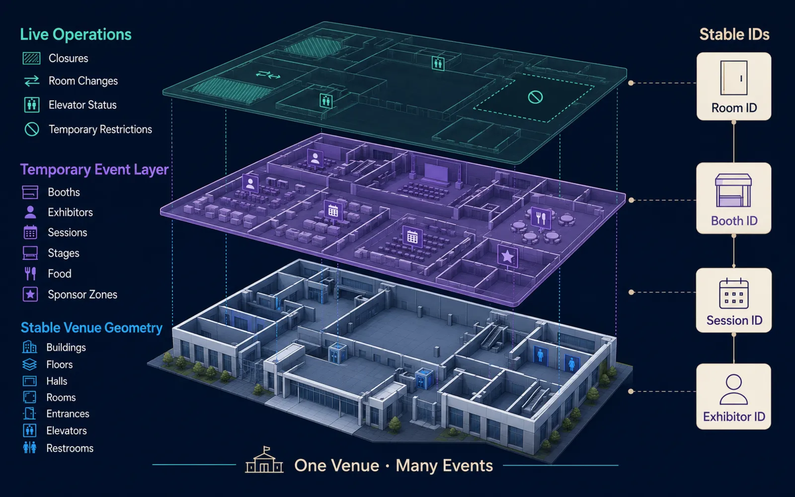
A third thin layer belongs to live operations. Closures, room changes, elevator outages, and temporary restrictions are not floor-plan features and they are not exhibitor records. Those records are time-stamped status. The explanation the visitor reads should reflect that status when the host publishes it. A booth relocated at 13:42 should not remain highlighted at the old coordinate because the language model still has yesterday’s overlay in context.
Temporary food, sponsor activations, and queue notices also belong on event or live layers. Stable restrooms, elevators, and building footprints should not be rewritten to host them. The map publishing guide covers production controls for maps that must stay current after launch; venue products have the same freshness problem at indoor scale.
Why Does Indoor Navigation Require More Than a Map Image?
A floor plan is not automatically a routable indoor network. Showing Room 204 on a map is place lookup: a stable identifier, a geometry, and a highlight. Indoor navigation additionally needs connected spaces, doors, corridors, stairs, elevators, floor transitions, restrictions, and accessible paths. Without that topology, a drawn line across a raster plan is decoration, not a validated route.
The Open Geospatial Consortium’s IndoorGML 1.1 standard specifies an open data model for indoor spatial information with a navigation purpose. It models topology and semantics of indoor spaces, including a core connectivity model and a navigation extension, and it is complementary to construction-oriented encodings such as CityGML and IFC rather than a substitute for them (IndoorGML 1.1, OGC 19-011r4, published 5 November 2020). That document is authoritative about the standard. A production venue product does not have to store IndoorGML, but it does have to respect the same distinction: space identity is not a navigation network.
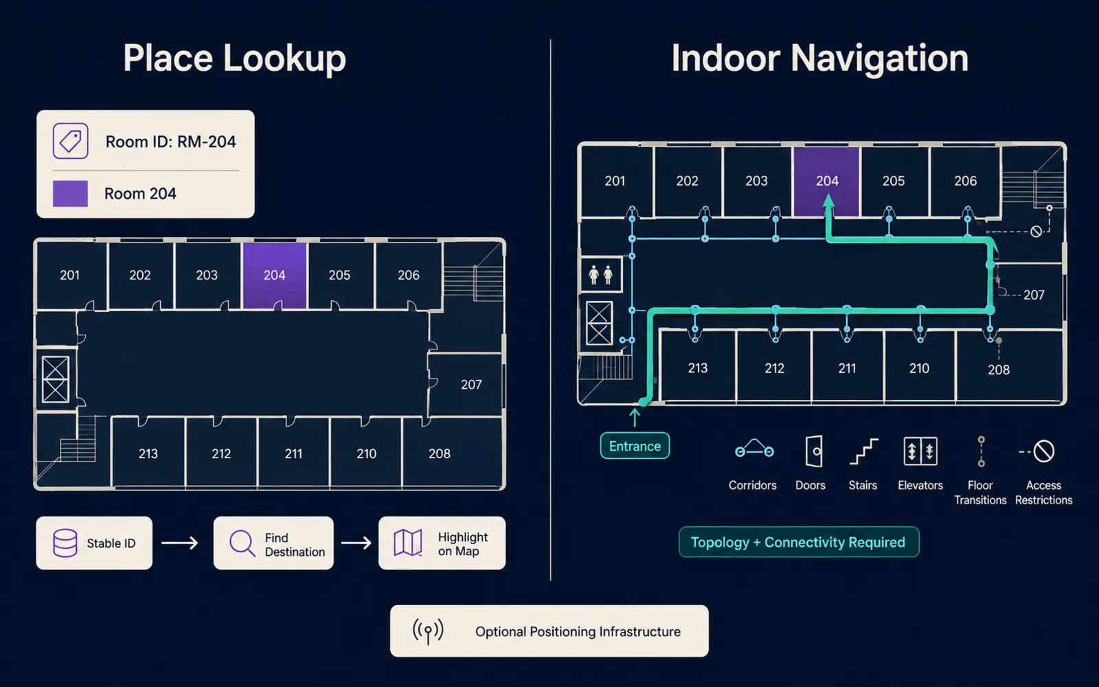
Indoor positioning is a third capability. Bluetooth beacons, Wi-Fi positioning, ultra-wideband, visual positioning, and venue-specific systems are infrastructure, not a language-model feature. The W3C Geolocation specification, a Candidate Recommendation Snapshot dated 26 March 2026, provides access to device location only after express permission, and it states that the API gives no guarantee of the device’s actual location. A browser location fix is not an indoor blue dot. Kaleidr’s current public documentation describes map-aware AI, published maps, custom maps, and attaching chat to an existing renderer; it does not document a dedicated indoor positioning system or a specialized indoor turn-by-turn engine (AI Map Chat for Customer Discovery, Chat attach). A realistic Kaleidr venue experience today should therefore be framed around conversational discovery, searchable spaces, highlighted destinations, event content, outdoor or campus routing where a routing provider exists, and integration with venue-specific indoor systems when the host actually operates them.
How Should Conversational Venue Search Share State With the Map?
Traditional venue search uses a room list, exhibitor directory, session list, or amenity icons. Conversation becomes useful when the request combines them. “Where can I get coffee between these two talks?” needs two session locations, a time window, amenity candidates, and a travel relationship. “Which entrance should I use for the north parking lot?” needs parking geometry, entrance eligibility, and often a ticket rule. The language model can translate those sentences into entity types, spatial relationships, and constraints. Deterministic search should still own Room 204, an exhibitor name, a session title, and an amenity category. The ideal interface is search, filters, map, and conversation for compound questions—not a chat panel that covers the floor plan.
Map, agenda, exhibitor directory, session list, and assistant should share one canonical state: event identifier, selected session, selected space, active floor, saved exhibitors, and current result identifiers. Selecting a session can highlight its room. Selecting a room can focus sessions that use it. Assistant results should appear on the same map and list rather than a second unofficial result set. The map-aware assistant guide covers shared map state and validated actions for that handoff.
Schedule-aware questions need clock time as well as geography. “What can I see before my next session?” is only useful if the recommended exhibitor is reachable before the session starts. Do not rank a nearby booth that the walking time, queue, or floor change makes impossible. If no agenda is available, ask which session rather than inventing one.
Map actions should be structured and host-validated: focus a space, show a set of spaces, switch floor, highlight a booth, request a route where routing exists, open a session, open an exhibitor, or clear results. Prefer semantic actions over arbitrary renderer calls. A floor-changing action should verify that the floor exists, the destination belongs to that floor, the visitor may see it, the event is active, and geometry exists for that floor.
Permissions for those actions belong to the application and infrastructure, never to the language model. OWASP’s LLM01:2025 Prompt Injection describes how user or retrieved text can alter model behavior, including influence over connected functions. The OWASP Top 10 for LLM Applications 2025 separately lists LLM06:2025 Excessive Agency: damaging actions from unexpected or manipulated model output when a system is granted too much functionality, permission, or autonomy. A venue assistant should propose a destination and an allowed action; the host application should execute the camera move, floor switch, or route request after schema, access, and venue-state validation.
How Do Tickets, Accessibility, and Live Operations Constrain Results?
Some venue areas are restricted by ticket type, badge, age, staff role, VIP access, or session registration. Access is a hard eligibility rule, not a ranking signal. Candidate spaces should pass ticket eligibility and operating status before spatial comparison, ranking, and explanation. The assistant should not expose a staff corridor or a speaker lounge merely because those polygons exist in the dataset. Restricted spaces should be filtered before retrieval so the model never has to “remember” which rooms are private.
Accessibility information should be treated as structured venue data. Step-free routes, elevators, accessible entrances, accessible restrooms, seating access, and temporary outages are records with status, not adjectives the model is free to attach. “What is the nearest accessible route to Hall B?” requires authoritative accessibility and topology. If the system only knows where Hall B is, it should say that an accessible route is not available from current data rather than inventing one. This post describes the data contract; whether a specific venue meets a legal accessibility duty is a judgment for qualified counsel and the venue operator.
Emergency and safety information is high-stakes. The assistant should not generate evacuation routes, emergency procedures, or restricted safety guidance from generic model knowledge. Use venue-approved emergency content, official signage, current operational systems, and human staff. If the map shows emergency exits or first-aid stations, those locations should come from authoritative venue records.
Venue apps may process current location, schedule, ticket, saved exhibitors, accessibility preferences, or movement history. The NIST Privacy Framework (NIST.CSWP.01162020, 16 January 2020) treats privacy as enterprise risk management: identify what is collected, why, and for how long. Prefer data minimization. Do not collect continuous indoor location merely because the map can display a marker. Separate temporary navigation context from persistent account history. Private location data for AI map workflows covers the same boundary for host-owned catalogs.
How Does Kaleidr Fit an Existing Venue Stack?
Kaleidr is designed to add conversational spatial interaction on top of an existing venue product rather than replace the event platform. The current Spatial AI page describes connecting listings, venues, store locations, or destination catalogs, grounding answers on inventory, brand voice, and policies, and deploying on the host website, app, or map (AI Map Chat for Customer Discovery). For venue products, the important split is unchanged: the host remains authoritative for rooms, booths, sessions, and tickets, and Kaleidr can add conversational map interaction and spatial explanation.
Kaleidr Chat can attach to a map the host already renders. Current Chat documentation mounts the conversational layer over a live Mapbox, MapLibre, Google Maps, or Leaflet instance, and the current quickstart shows the same host-owned map handoff (Chat attach, Quickstart). Enterprise surfaces describe APIs, SDKs, and deployment support for putting that layer inside an existing stack (Location Intelligence APIs and Map SDK). A Kaleidr implementation can coordinate retrieval, geospatial services, map behavior, and analytics depending on the deployment configuration. Indoor positioning and indoor turn-by-turn remain venue-specific systems unless the host integrates them.
Not every event needs that depth. A curated event guide can include venue zones, points of interest, routes, sponsor areas, dining, and explanatory content. Kaleidr Studio currently supports prompt-first custom map creation, custom layers, branded styling, publishing, and embedding (AI Map Maker for Branded Interactive Maps). Studio is a good fit when the experience is primarily curated. Use deeper integration when schedule changes live, ticket rules affect results, personalized agendas matter, or operational state is dynamic.
Browser and backend credentials should stay separated. Kaleidr’s current authentication model uses publishable browser keys and secret server keys for trusted backend calls (Auth & Scopes). Venue systems should likewise keep ticket APIs, private staff-space payloads, and indoor-positioning credentials off the browser unless a client-side flow is explicitly designed for them.
What Should Analytics Measure on an Event Venue Map?
Measure whether visitors find and act on destinations, not only whether they open the map. A practical journey runs from opening the map, through search or a question, a returned result, a selected destination, optional guidance, and an event action such as arriving at a room or opening an exhibitor. Spatial diagnostics belong underneath that journey: hall, floor, entrance, amenity, exhibitor, session. Failure modes such as no result, wrong floor, route failure, access denied, and stale location explain where the product stalled.
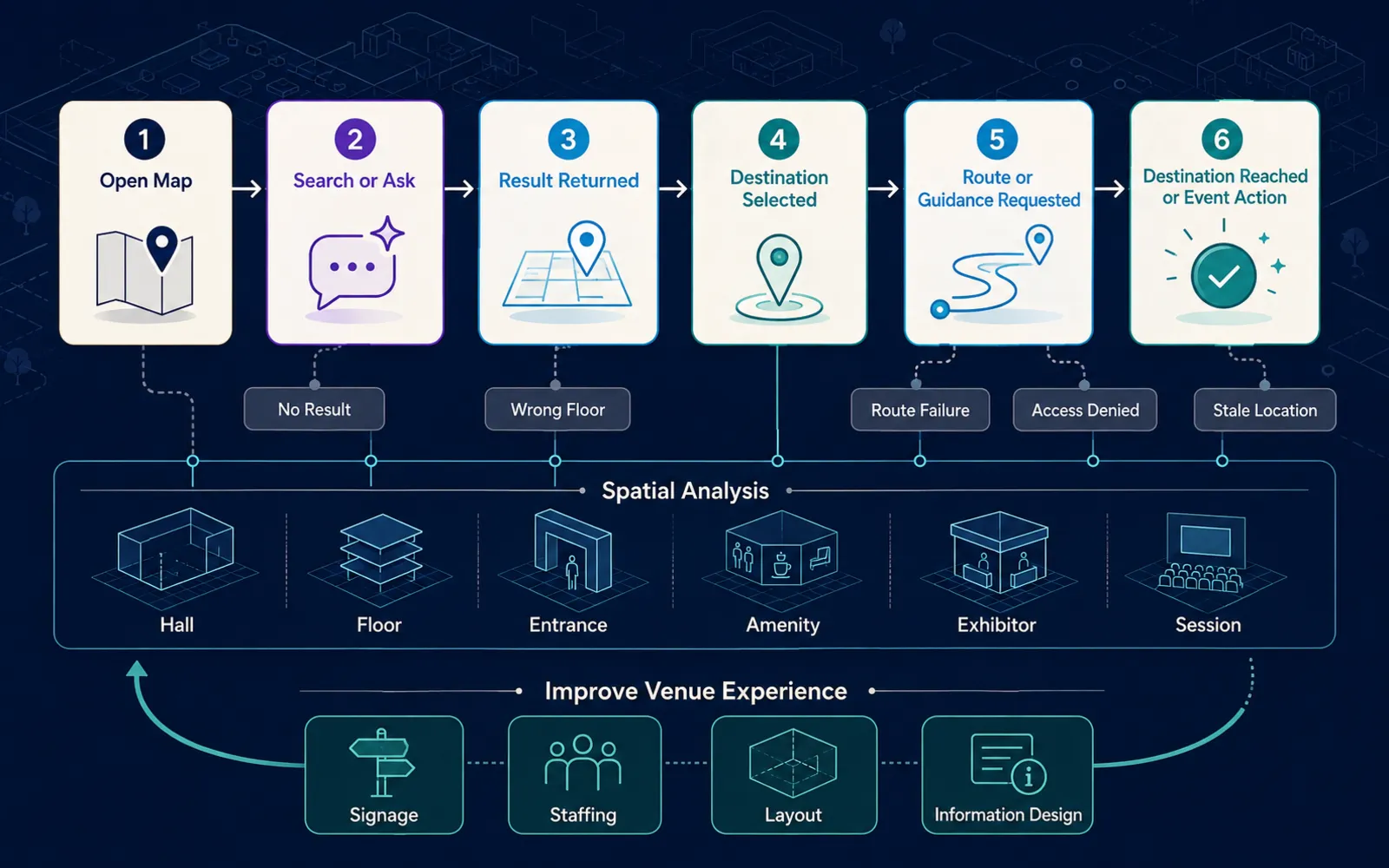
Editorial event ideas include map opened, search submitted, question submitted, space selected, floor changed, exhibitor selected, session opened, amenity selected, route requested, no result, access denied, and action completed. Those names are product-design suggestions, not documented automatic Kaleidr Analytics events. Kaleidr Analytics currently frames measurement around map and place engagement—sessions, views, interactions, and audience activity tied to places rather than only URLs (Map Engagement and Location Analytics). Host task completion still has to be joined from the venue or event system if the outcome is a found room, a visited booth, or a checked-in session. The spatial analytics KPI guide covers the same preference for task completion over raw interaction volume.
Spatial patterns can reveal heavily searched rooms, confusing entrances, amenities visitors repeatedly ask for, zones with failed searches, exhibitors with high map interest, or friction between consecutive sessions. That evidence can inform signage, staffing, layout, and information design. Do not optimize only for map views. A session that found Room 204 on the correct floor before the talk is a better outcome than a long conversation that never highlighted a space.
What Limits and Failure Modes Should Product Teams Expect?
Venue maps are primarily mobile. Design for one-handed use, large tap targets, readable floor controls, a bottom-sheet for results, a fast return to the map, poor connectivity, sunlight, and crowds. Avoid covering the entire map with a chat panel. Keep a compact assistant and an expandable result sheet. Large venues often have unreliable networks: cache base geometry and labels, degrade conversation gracefully, and keep a text directory. If the language-model layer is unavailable, the map should still locate Hall B.
Test venue-specific ambiguity on purpose. Hall A versus Hall A1, North Hall versus North Entrance, Main Stage versus Stage 1, and Room 204 versus Booth 204 should resolve through stable IDs and type context, not string equality. If Hall B spans floors, “coffee near Hall B” may need a clarification. “Show the restroom closest to Room 204” should use Room 204’s floor, not whichever floor the camera currently shows. Simulate a room move, a closed entrance, an unavailable elevator, a canceled session, and a relocated exhibitor, and require map, list, and explanation to update from the same source.
Do not invent scarcity, “the best booth,” or emergency instructions the venue system did not supply. Do not disguise paid or sponsor ranking as neutral relevance. Do not make conversation a required step. Match map actions to the geometry and APIs the host actually publishes.
| Failure mode | What goes wrong | Safer contract |
|---|---|---|
| Treat the floor plan as a router | Paths cross walls or skip floors | Require topology before routing claims |
| Let the model invent rooms or times | Visitors miss sessions | Retrieve from venue and schedule systems |
| Names without stable IDs | Room, booth, and session collide | Keep typed entity identifiers |
| Mix geometry and event overlay | Next show rebuilds the building | Separate stable and temporary layers |
| Ignore floor state | Wrong-floor highlights | Track floor in shared state |
| Promise indoor positioning | Product overclaims | Distinguish lookup, routing, and positioning |
| Recommend restricted areas | Access rules leak | Filter before retrieval |
| Chat as the only search | Simple lookups get slower | Keep deterministic search |
| Chat-volume metrics only | Usage looks like success | Measure destination and action completion |
Build an AI Venue Map Experience
See how a conversational map, event catalogs, and enterprise APIs can sit on an existing venue or event stack without replacing the renderer or the reservation system. Explore Kaleidr Enterprise for current APIs, SDK surfaces, and deployment support.
FAQs
What is an AI venue map?
An AI venue map combines venue or event data with an interactive map and conversational interpretation so visitors can ask natural-language questions and receive grounded place results and map actions.
What can visitors ask?
Common questions include where a room is, which exhibitors are near a session, where amenities are, which entrance to use, or what is close to a selected destination.
Does an AI venue map need indoor mapping data?
For simple place lookup, it needs accurate venue geometry and identifiers. For indoor routing, it also needs connectivity and navigation information such as corridors, doors, stairs, elevators, and restrictions.
Can a language model generate indoor routes from a floor-plan image?
That output should not be treated as authoritative. Reliable indoor routing requires a structured navigation network or equivalent venue-specific routing data.
What is IndoorGML?
IndoorGML 1.1 is an Open Geospatial Consortium standard for representing indoor spaces, connectivity, navigation context, and indoor navigation networks (OGC 19-011r4).
Does Kaleidr provide indoor positioning?
Kaleidr’s current public documentation describes spatial AI, map chat, custom maps, publishing, and existing-map integration. It does not currently document a dedicated indoor positioning system, so indoor positioning should be treated as a separate deployment capability unless the host integrates one.
Should conversation replace venue search?
No. Direct room, exhibitor, session, and amenity search should remain available. Conversation is most useful for multi-part or contextual questions.
How should ticket restrictions work?
Access rules should be applied deterministically before restricted spaces or content are returned to the language model or the visitor.
Can an AI venue map use a visitor’s schedule?
Yes, when the host application has permission to access the user’s agenda. The schedule system should remain authoritative for session times and locations.
Can Kaleidr attach to an existing venue map?
Yes. Kaleidr’s current developer documentation supports attaching Chat to existing compatible map implementations while the host keeps its renderer, data, and workflow.
Can Kaleidr Studio publish event maps?
Yes. Studio currently supports custom interactive map authoring and publishing, and Kaleidr’s sharing materials cite event organizers using interactive maps for venues, routes, and points of interest.
How should an AI venue map be measured?
Measure whether visitors successfully find rooms, exhibitors, sessions, entrances, amenities, or other destinations, along with no-result rates, incorrect-floor errors, route failures, and downstream event engagement.
References
- Kaleidr. AI Map Chat for Customer Discovery. Accessed 25 August 2026. https://kaleidr.com/ai
- Kaleidr. AI Map Maker for Branded Interactive Maps. Accessed 25 August 2026. https://kaleidr.com/studio
- Kaleidr. AI-Powered Map Experiences for Business. Accessed 25 August 2026. https://kaleidr.com/
- Kaleidr. Auth & Scopes. Kaleidr Developer Docs. Accessed 25 August 2026. https://docs.kaleidr.com/platform-api/auth-and-scopes
- Kaleidr. Chat attach. Kaleidr Developer Docs. Accessed 25 August 2026. https://docs.kaleidr.com/sdk/chat-attach
- Kaleidr. Location Intelligence APIs and Map SDK. Accessed 25 August 2026. https://kaleidr.com/enterprise
- Kaleidr. Map Engagement and Location Analytics. Accessed 25 August 2026. https://kaleidr.com/analytics
- Kaleidr. Quickstart. Kaleidr Developer Docs. Accessed 25 August 2026. https://docs.kaleidr.com/quickstart
- National Institute of Standards and Technology. NIST Privacy Framework: A Tool for Improving Privacy through Enterprise Risk Management, Version 1.0. NIST.CSWP.01162020. 16 January 2020. https://nvlpubs.nist.gov/nistpubs/CSWP/NIST.CSWP.01162020.pdf
- Open Geospatial Consortium. IndoorGML 1.1. OGC 19-011r4. 5 November 2020. https://docs.ogc.org/is/19-011r4/19-011r4.html
- OWASP Gen AI Security Project. LLM01:2025 Prompt Injection. Accessed 25 August 2026. https://genai.owasp.org/llmrisk/llm01-prompt-injection/
- OWASP Gen AI Security Project. OWASP Top 10 for LLM Applications 2025. Accessed 25 August 2026. https://owasp.org/www-project-top-10-for-large-language-model-applications/assets/PDF/OWASP-Top-10-for-LLMs-v2025.pdf
- W3C. Geolocation. W3C Candidate Recommendation Snapshot, 26 March 2026. Accessed 25 August 2026. https://www.w3.org/TR/geolocation/
@misc{kaleidr_ai_venue_2026_08_25,
  title  = {AI Map Chat for Customer Discovery},
  author = {{Kaleidr}},
  note   = {Accessed 25 August 2026},
  url    = {https://kaleidr.com/ai}
}

@misc{kaleidr_studio_venue_2026_08_25,
  title  = {AI Map Maker for Branded Interactive Maps},
  author = {{Kaleidr}},
  note   = {Accessed 25 August 2026},
  url    = {https://kaleidr.com/studio}
}

@misc{kaleidr_home_venue_2026_08_25,
  title  = {AI-Powered Map Experiences for Business},
  author = {{Kaleidr}},
  note   = {Accessed 25 August 2026},
  url    = {https://kaleidr.com/}
}

@misc{kaleidr_auth_scopes_2026_08_25,
  title  = {Auth \& Scopes},
  author = {{Kaleidr}},
  note   = {Kaleidr Developer Docs; accessed 25 August 2026},
  url    = {https://docs.kaleidr.com/platform-api/auth-and-scopes}
}

@misc{kaleidr_chat_attach_2026_08_25,
  title  = {Chat attach},
  author = {{Kaleidr}},
  note   = {Kaleidr Developer Docs; accessed 25 August 2026},
  url    = {https://docs.kaleidr.com/sdk/chat-attach}
}

@misc{kaleidr_enterprise_venue_2026_08_25,
  title  = {Location Intelligence APIs and Map SDK},
  author = {{Kaleidr}},
  note   = {Accessed 25 August 2026},
  url    = {https://kaleidr.com/enterprise}
}

@misc{kaleidr_analytics_venue_2026_08_25,
  title  = {Map Engagement and Location Analytics},
  author = {{Kaleidr}},
  note   = {Accessed 25 August 2026},
  url    = {https://kaleidr.com/analytics}
}

@misc{kaleidr_quickstart_venue_2026_08_25,
  title  = {Quickstart},
  author = {{Kaleidr}},
  note   = {Kaleidr Developer Docs; accessed 25 August 2026},
  url    = {https://docs.kaleidr.com/quickstart}
}

@techreport{nist_privacy_framework_2020,
  title       = {NIST Privacy Framework: A Tool for Improving Privacy through Enterprise Risk Management, Version 1.0},
  author      = {{National Institute of Standards and Technology}},
  number      = {NIST.CSWP.01162020},
  institution = {National Institute of Standards and Technology},
  year        = {2020},
  month       = jan,
  url         = {https://nvlpubs.nist.gov/nistpubs/CSWP/NIST.CSWP.01162020.pdf}
}

@techreport{ogc_indoorgml_1_1,
  title       = {IndoorGML 1.1},
  author      = {{Open Geospatial Consortium}},
  number      = {OGC 19-011r4},
  institution = {Open Geospatial Consortium},
  year        = {2020},
  month       = nov,
  url         = {https://docs.ogc.org/is/19-011r4/19-011r4.html}
}

@misc{owasp_llm01_prompt_injection_2025,
  title  = {LLM01:2025 Prompt Injection},
  author = {{OWASP Gen AI Security Project}},
  note   = {Accessed 25 August 2026},
  url    = {https://genai.owasp.org/llmrisk/llm01-prompt-injection/}
}

@misc{owasp_llm_top10_2025,
  title  = {OWASP Top 10 for LLM Applications 2025},
  author = {{OWASP Gen AI Security Project}},
  note   = {Accessed 25 August 2026},
  url    = {https://owasp.org/www-project-top-10-for-large-language-model-applications/assets/PDF/OWASP-Top-10-for-LLMs-v2025.pdf}
}

@misc{w3c_geolocation_2026_03_26,
  title  = {Geolocation},
  author = {{W3C}},
  note   = {W3C Candidate Recommendation Snapshot, 26 March 2026; accessed 25 August 2026},
  url    = {https://www.w3.org/TR/geolocation/}
}