
Location intelligence customer experience uses geographic context, authorized business data, and customer intent to help a person discover, compare, and act on the right place. Traditional location intelligence often visualizes geospatial data for internal analysis. A customer-facing product instead answers which location fits the current request and offers a next action such as directions, booking, inquiry, or pickup. Trusted systems remain authoritative for inventory and policy; geospatial services calculate distance, travel time, and containment; a language model interprets complex intent.
The sections below separate dashboard-style location intelligence from a customer decision surface, then cover data, architecture, industry patterns, measurement, and where Kaleidr fits. Related reading includes What Is a Location Intelligence API?, What Is Spatial AI?, and How to Build a Map-Aware AI Assistant.
Location intelligence customer experience essentials
- Decision first: Name the customer choice and the business action before choosing a map or model.
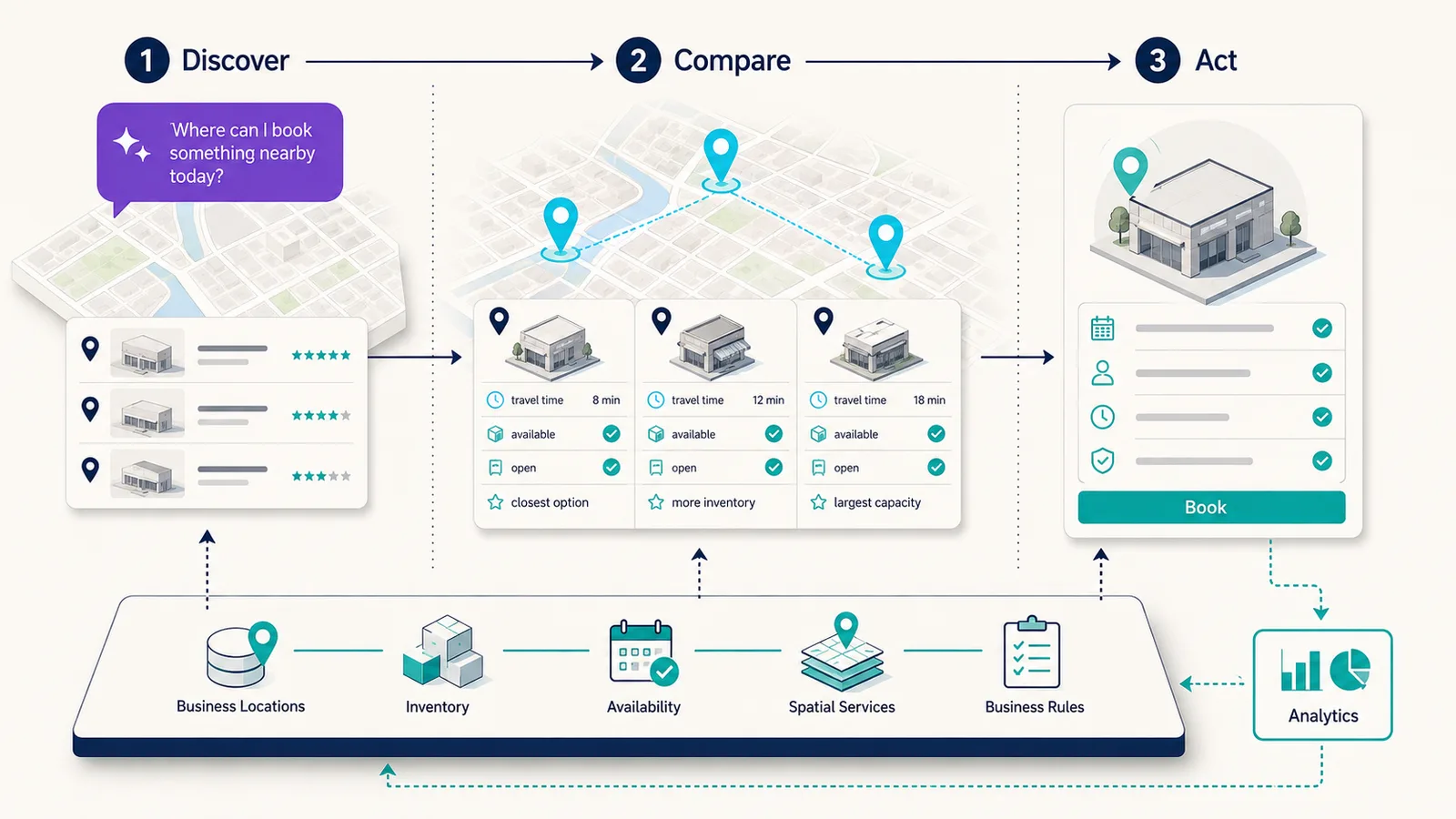
- Discover → Compare → Act: Relevant places, inspectable tradeoffs, then a next step the host can complete.
- Hard filters before ranking: Eligibility and availability come before travel time or preference.
- AI interprets intent: Geospatial services calculate geometry; business systems own inventory and policy.
- Measure the action: Directions, booking, inquiry, pickup, or save beat pans, marker clicks, and chat volume.
How Does Location Intelligence Customer Experience Differ From Analysis?
Vendor definitions still describe location intelligence mainly as insight for operators. Esri currently defines the term as “the insight gained from visualizing and analyzing geospatial data,” typically by layering demographics, traffic, environment, economics, and weather on a smart map or dashboard so leaders can plan what to do next (What is Location Intelligence?). Google Maps Platform uses a related framing: mapping and geospatial data combined with internal customer data to improve customer experience and business processes (Location intelligence: the new frontier for data-driven success). Mapbox’s May 2026 definition similarly connects geospatial data, business data, movement, and context so teams can make decisions across operations, strategy, and customer experience (What is location intelligence?). Those pages are authoritative about how each vendor uses the phrase. None of them specifies a customer-facing product contract.
The useful distinction for a product team is the job, not the brand label. Analysis-oriented location intelligence answers where to open a store, how a territory performs, or where demand concentrates. Location intelligence customer experience answers a different question in the session: which place is right for this customer, under these constraints, right now. Site selection, territory design, and operations dashboards remain important. The customer-facing layer must still retrieve eligible inventory, calculate a spatial relationship, rank remaining options, and hand a selected place to a host workflow.
A map that only plots markers therefore stops short of the job. The customer still has to infer travel time, hours, inventory, and policy from cards that may disagree with the map. A decision surface keeps those facts in one shared state and ends in an action the business can complete. The location-intelligence API guide covers the programmable form of that coordination.
How Does Discover, Compare, and Act Organize the Product?
A practical customer-facing model has three stages that share one search state. Discover identifies candidate places from origin, geography, category, hours, inventory, and policy. Compare makes tradeoffs visible: travel time, operating status, amenities, accessibility, route fit, and business-defined priority. Act is the outcome the product exists to make easier—directions, booking, reservation, inquiry, purchase, pickup, save, share, or contact. Designing backward from the action prevents a map that looks complete while leaving the customer without a next step.
Discover is where conventional search boxes and category filters still earn their place. A request such as hotels near a venue, stores that offer a named service, or listings inside a commute threshold can often be expressed as structured controls. Natural-language interpretation helps when the customer combines several constraints: an origin, a time window, a service, and a preference that would otherwise become four separate filters. The language model should return those constraints as inspectable state, not bury them in chat history.
Compare is where the map earns its keep. A flat list can sort by price or rating and still hide that two “nearby” options sit on opposite sides of a river, outside walking range, or on the wrong side of a one-way approach. The interface should keep the same place identifiers on the map, the list, and the detail pane so a selection in one surface updates the others. Reasons shown on a card should map to calculated or retrieved facts—travel time from the selected origin, a service the store system reports, or hours the business system reports as open.
Act is not a marker click. The host application owns the transaction, reservation, or routing handoff; the spatial layer should return a stable place identifier, enough context to explain the choice, and a structured action the host already supports. The map-aware assistant guide walks through shared map state and validated actions for that handoff.
What Data and Architecture Does a Customer-Facing Map Need?
Customer-facing location intelligence depends on several data classes with different owners. Location identity—store, hotel, venue, or property—belongs to the business or place provider. Geometry belongs to a spatial system. Inventory, availability, hours, and booking windows belong to business backends. Customer origin and preferences belong to the host application after consent. Distance, route time, and containment belong to a geospatial service. Ranking policy belongs to the host. Interaction history belongs to analytics. A language model should not invent values that live in those systems.
| Data class | Examples | Typical owner |
|---|---|---|
| Location identity | Store, hotel, venue, property | Business or place provider |
| Geometry | Coordinates, boundaries, routes | Spatial system |
| Business state | Inventory, availability, status | Business backend |
| Time | Hours, booking window, event schedule | Business system |
| Customer context | Selected origin, preferences | Host application |
| Spatial relationship | Distance, route time, containment | Geospatial service |
| Ranking | Eligibility, relevance, preference | Host or ranking layer |
| Interaction | Searches, selections, actions | Analytics |
The order of operations matters as much as the data. A production path can run from the host application through authorization and business rules, then location and inventory retrieval, spatial calculation, eligibility, ranking, explanation, synchronized map and list output, and outcome analytics. Generating a recommendation first and checking business reality afterward inverts that order and produces places the customer cannot actually use.
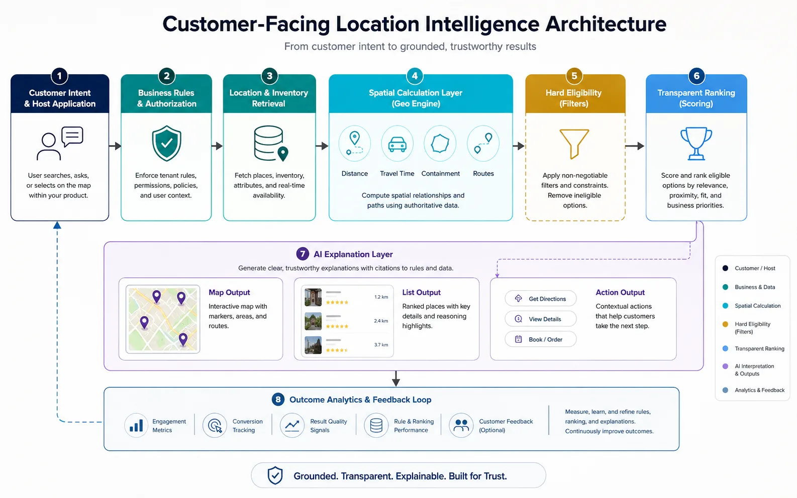
Exact geometry still belongs to a spatial engine. OGC Simple Feature Access, also published as ISO 19125, defines the common architecture for simple feature geometry and the spatial operations implementations expose for points, curves, surfaces, and collections (Simple Feature Access — Part 1). The W3C and OGC Spatial Data on the Web Best Practices separately emphasize using web architecture and clear spatial-data practices so geographic objects remain discoverable and reusable. Production systems should therefore let the language model interpret intent and choose an operation, while a geospatial engine or database calculates distance, route, intersection, and containment.
Device location is optional context, not a prerequisite. The W3C Geolocation specification, a Candidate Recommendation Snapshot dated 26 March 2026, provides access to device location only after express permission, and the specification states that the API gives no guarantee of the device’s actual location. A typed address, a selected map point, or a saved origin is often enough and avoids collecting precise coordinates the product does not need. For private catalogs and tenant data, see Private Location Data for AI Map Workflows.
How Should Eligibility, Ranking, and AI Stay Separate?
Hard eligibility is binary: the place is open, the service is offered, the listing is active, the room is bookable, the ticket covers the area, or the delivery zone includes the address. Soft preference is comparative: shorter travel time, a better neighborhood fit, more relevant amenities, a preferred brand, a lower price, or a better schedule. The system should apply hard constraints before ranking preferences. A closed store with a convenient coordinate is not a good first result.
Location is not synonymous with nearest-neighbor search. The closest coordinate can be the wrong choice when walking time, parking, transit, route direction, service area, entrance, or accessibility decides the trip. Useful relationships include near, inside, along a route, reachable within a time budget, same service area, cardinal direction, between two points, closest by route, and inside the selected map area. The product should calculate the relationship the decision actually requires, then show that relationship as a reason.
AI adds value when the request is hard to express as one filter. “Which of these hotels is easiest from the airport and still close to the event?” combines origin, mode, and a second destination. “Find a store that has the service I need and is open after eight” combines inventory, hours, and origin. The language model can translate that request into structured intent. Availability, route time, and place facts should still come from trusted systems. Keep deterministic controls when the request is already simple: open now, within a named radius, price ceiling, accessibility, bedroom count, or pickup. Do not force chat when one checkbox is faster.
Visible constraints close the loop. If the customer asks for nearby stores with pickup that are open tonight, the interface can show chips for origin, pickup, and open tonight. The same state should drive the map and the list so the customer can edit a constraint without restarting the conversation. One shared model—origin, geography, filters, candidate IDs, eligible IDs, ranking, and selected place—keeps chat, list, map, and detail aligned. Reasons attached to a result should cite retrieved or calculated facts, never “the assistant prefers this place.”
How Do Hospitality, Booking, Retail, and Property Journeys Use the Pattern?
The vertical changes; the core pattern does not. Kaleidr’s current Spatial AI page describes an AI guest concierge that helps travelers explore properties, amenities, and nearby partners on a map, and it states that answers can be grounded on a business’s inventory, brand voice, and policies rather than generic web search alone (AI Map Chat for Customer Discovery). A hospitality request such as dinner within a short walk that the hotel recommends still needs the hotel’s approved partner list as the source. The language model interprets the guest request; the map shows the spatially valid options; the host keeps policy.
Kaleidr’s homepage currently positions the platform around booking and marketplace experiences in which location, availability, and customer intent influence the decision (AI-Powered Map Experiences for Business). The booking engine remains authoritative for price, inventory, and reservation state. The spatial layer helps the customer compare available options by itinerary fit, travel time, and geographic context. Retail follows the same split: AI Store Locator With Map Chat keeps store systems authoritative for hours and services, then uses conversation for multi-part local needs. Property search can add commute, transit, amenities, and user-drawn areas on top of listing facts the authorized inventory already owns. Destination and tourism maps use a similar stack when the catalog is curated rather than live transactional inventory; How to Build an AI-Powered Tourism Map covers that workflow.
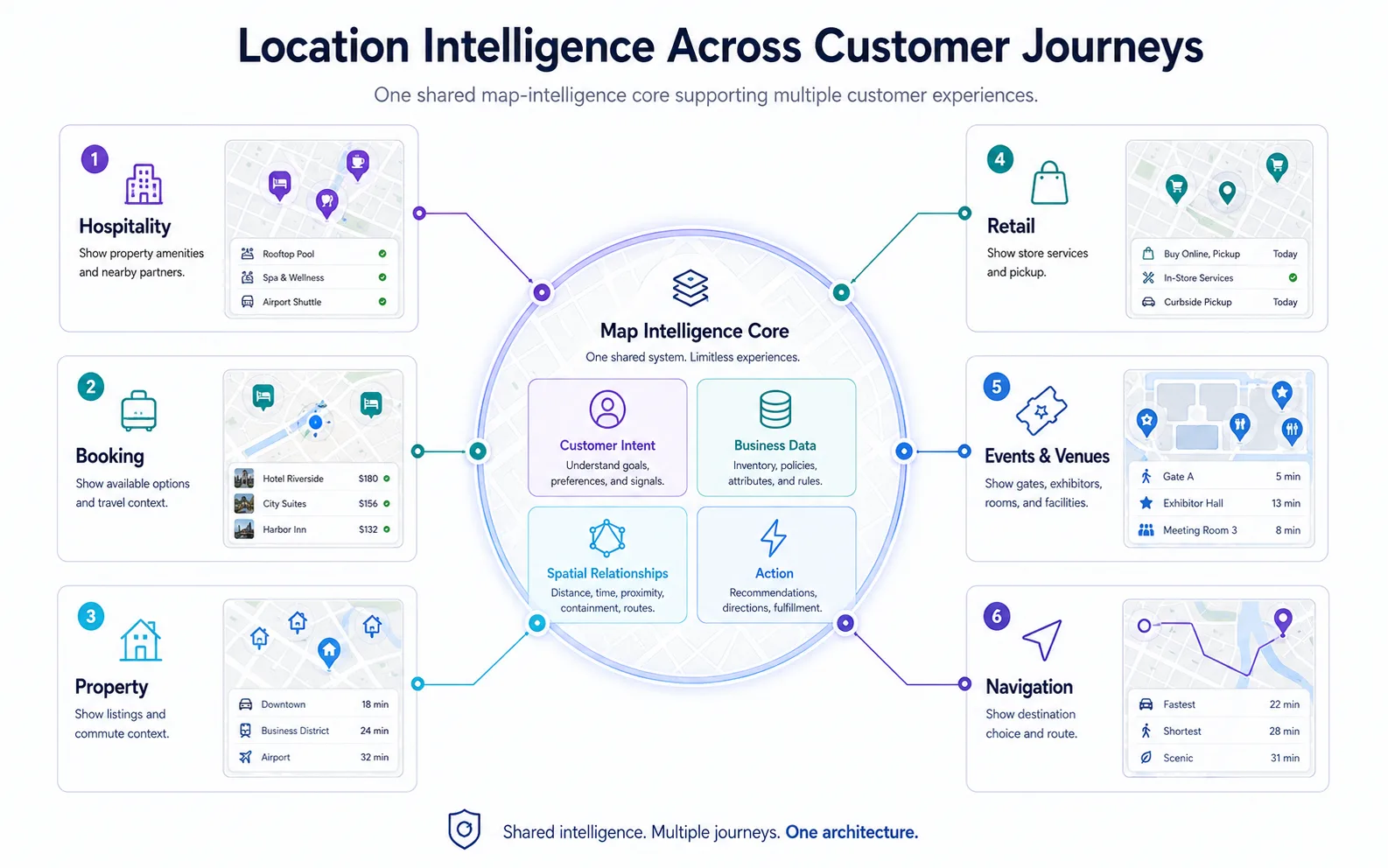
Venue and navigation products apply the same boundaries. A visitor looking for an accessible entrance or exhibitors near the next session needs indoor or campus geometry, ticket rules, and schedule data the venue system owns. Navigation often starts earlier than routing: the customer still has to choose a destination before a routing engine should calculate a path. In both cases the geospatial service calculates the relationship; the host remains authoritative for access rules and the final handoff.
Teams should attach this layer to an existing renderer when the product already runs Mapbox, Google Maps, MapLibre, or Leaflet. Kaleidr’s current developer documentation describes Chat as a mount over a live map instance that can attach to those renderers while the host keeps the map, application state, and business workflow (Chat attach). Use a published Studio map when the experience is a curated guide rather than a live inventory loop. Kaleidr Studio currently supports prompt-first map authoring and publishing as a standalone page or embed (AI Map Maker for Branded Interactive Maps). Live booking, store, or listing state still belongs in a developer integration.
How Should Teams Measure Location Intelligence Customer Experience?
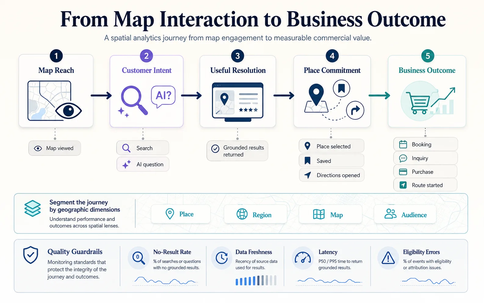
Measurement should follow the same Discover → Compare → Act path the customer uses. Kaleidr Analytics currently describes a dashboard for map and place engagement—sessions, views, interactions, audience activity, and spatial trends—rather than URL-only web analytics (Map Engagement and Location Analytics). A customer-experience program still needs outcome events the host already knows how to record: an eligible place selected, directions opened, booking or inquiry started, purchase or pickup begun, a listing saved, or a route started. Pan, zoom, and chat-message counts are supporting signals. Those counts are not proof that the map improved the decision.
| Experience | Useful outcome |
|---|---|
| Hospitality | Guest found a place or service, or started a booking |
| Booking | Booking started or completed |
| Property | Listing saved or inquiry started |
| Retail | Eligible store selected, directions, or pickup |
| Events and venues | Destination or route resolved |
| Navigation | Route started or destination reached |
| Marketplace | Eligible provider selected and transaction started |
Geographic friction is the failure mode conventional page analytics misses. High no-result rates in one area, searches around a store with low conversion, places compared but rarely selected, queries outside coverage, failed route requests at an entrance, or inventory that does not match demand geography all point to data or eligibility problems. Spatial Analytics Dashboard KPIs covers denominators, governed place identifiers, and privacy-preserving aggregation.
Location data can be sensitive even when no single field looks sensitive. Precise current location, a home address, a travel plan, or repeated search origins can reveal identity and behavior. Collect device location only when the product cannot use a typed or selected origin; avoid storing exact search coordinates by default; aggregate analytics geography where possible; and keep public map context separate from private account data. The W3C Geolocation specification requires express permission before a web application receives device location and notes that privacy law in a given jurisdiction may impose further duties. Treat that as a description of the platform rule, not as legal advice for a specific deployment.
A customer-facing page should never contain a privileged server credential. Kaleidr’s current developer model uses publishable browser keys and server keys for trusted backends, with capability scopes (Auth & Scopes). Map API Authentication covers origin restrictions and key separation.
Where Does Kaleidr Fit in a Customer-Facing Stack?
Kaleidr currently describes four related layers on the homepage: conversational spatial AI, branded interactive map authoring in Studio, place-level analytics, and enterprise developer infrastructure. The Spatial AI surface is designed for natural-language place discovery and map-aware recommendations on an interactive map. Studio is designed for prompt-first creation and publishing of branded maps. Analytics is designed to show how audiences discover and engage with maps and places. Enterprise packages location-intelligence APIs, ranking, and spatial infrastructure for product stacks that already have a renderer and business systems.
The resulting mix is closer to spatial AI plus location intelligence plus AI mapping than to a back-office GIS dashboard. Spatial AI does not replace Mapbox, Google Maps, MapLibre, a GIS database, geocoding, routing, or the booking and inventory systems the host already runs. The host remains authoritative for data, permissions, business rules, map rendering, and exact geographic computation. The spatial-AI layer makes those systems easier to query and act on; the layer is not the source of truth for geometry or inventory.
Use a Studio or template path when the workflow is standardized and a curated map is enough. Attach Chat to an existing map when live application state and existing filters must stay authoritative; How to Add AI Chat to a Map covers renderer mounts. Use Enterprise or API integration when private or licensed data, organization-level usage, or ranking against internal systems is required.
Which Mistakes Should Customer-Experience Teams Avoid?
Treating location intelligence as a dashboard-only capability leaves the customer with a generic locator. Ranking the nearest coordinate first can promote an ineligible place. Letting a language model invent availability makes recommendations untrustworthy. Hiding constraints in chat history prevents correction. Driving the map and list from different queries splits the experience. Measuring only pans, marker clicks, or chat messages mistakes activity for value. Collecting precise location by default grows privacy risk without improving the decision. Replacing simple filters with conversation slows tasks that one checkbox already solves. Replacing a working map stack when attach is enough raises migration cost without changing the customer job.
| Mistake | Result | Better approach |
|---|---|---|
| Dashboard-only location intelligence | Customer experience stays generic | Put spatial context on the decision surface |
| Nearest place wins automatically | Ineligible locations rank first | Filter eligibility, then rank by route and intent |
| Model-invented availability | Recommendations fail at the counter | Keep the business system authoritative |
| Hidden chat constraints | Customers cannot correct the search | Convert intent into visible state |
| Map and list from different queries | Surfaces disagree | Share one search state |
| Map-interaction metrics only | Activity looks like success | Measure booking, directions, inquiry, save |
| Precise location by default | Privacy risk grows | Use the minimum useful origin |
| Chat instead of a checkbox | Simple tasks slow down | Keep filters for explicit constraints |
| Unnecessary renderer replacement | Migration cost rises | Attach spatial AI where the map already works |
Final Verdict
Location intelligence customer experience is most useful when the product stops showing only where a place is and starts answering which place is right for this customer, in this context, right now. Esri, Google Maps Platform, and Mapbox still define location intelligence around geospatial data plus business context for better decisions. The customer-facing job adds a product contract on top of those definitions: discover eligible places, compare them with inspectable spatial and business facts, and complete a host-owned action.
The compact pattern is Discover → Compare → Act, supported by trusted business data, spatial calculation, eligibility, ranking, explanation, map action, and outcome analytics. A language model interprets intent. Trusted systems provide facts. Geospatial engines calculate relationships. The application applies the result. Kaleidr currently organizes that loop across Spatial AI, Studio, Analytics, and Enterprise while leaving the existing renderer and business systems authoritative.
Add Location Intelligence to Your Product
See how location-aware ranking, map-aware recommendations, and enterprise spatial APIs fit an existing product stack. Explore Kaleidr Enterprise for current APIs, SDK surfaces, and deployment support.
FAQs
What is location intelligence customer experience?
Location intelligence customer experience uses geographic context, place data, business data, and customer intent to help a person choose a location and take a next action such as directions, booking, inquiry, or pickup.
How is customer-facing location intelligence different from traditional location intelligence?
Traditional location intelligence often supports internal analysis such as site selection, territory planning, or operations. Customer-facing location intelligence puts relevant spatial context into search, booking, shopping, property, hospitality, venue, or navigation so the customer can decide during the session.
Does location intelligence require AI?
No. Many tasks use deterministic spatial queries, filters, and ranking. AI becomes useful when the request combines several constraints, preferences, or follow-up questions that are cumbersome as fixed controls.
What data should an AI map use?
Use authoritative place and business records for coordinates, inventory, hours, availability, status, and eligibility. A language model should interpret intent and explain results rather than invent operational facts.
Why is travel time often better than straight-line distance?
Straight-line distance ignores streets, barriers, transit, and approach direction. Travel time usually better represents the customer’s actual convenience, provided a routing or travel-time service calculates it.
Should AI replace map filters?
Usually no. Filters remain useful for explicit, repeatable constraints. Conversation is most useful for multi-variable requests that would otherwise become a long filter form.
How should locations be ranked?
Apply hard eligibility first, then rank remaining places with travel time, availability, preference, and business-defined rules. Show reasons that map to retrieved or calculated facts.
What industries benefit from customer-facing location intelligence?
Hospitality, booking, property, retail, marketplaces, events and venues, tourism, mobility, and navigation all depend on choosing a physical place before the customer can complete the job.
How should teams measure these experiences?
Measure useful outcomes such as an eligible place selected, directions opened, booking started, inquiry submitted, purchase initiated, property saved, or route started—not only map views or chat messages.
Can Kaleidr work with an existing map?
Yes. Kaleidr’s current developer documentation supports attaching conversational AI to existing Mapbox, Google Maps, MapLibre, or Leaflet implementations while the host keeps the renderer and business systems.
References
- Esri. What is Location Intelligence? Accessed 22 August 2026. https://www.esri.com/en-us/location-intelligence/overview
- Google Maps Platform. Location intelligence: the new frontier for data-driven success. Accessed 22 August 2026. https://mapsplatform.google.com/resources/blog/location-intelligence-new-frontier-data-driven-success/
- Kaleidr. AI Map Chat for Customer Discovery. Accessed 22 August 2026. https://kaleidr.com/ai
- Kaleidr. AI Map Maker for Branded Interactive Maps. Accessed 22 August 2026. https://kaleidr.com/studio
- Kaleidr. AI-Powered Map Experiences for Business. Accessed 22 August 2026. https://kaleidr.com/
- Kaleidr. Auth & Scopes. Kaleidr Developer Docs. Accessed 22 August 2026. https://docs.kaleidr.com/platform-api/auth-and-scopes
- Kaleidr. Chat attach. Kaleidr Developer Docs. Accessed 22 August 2026. https://docs.kaleidr.com/sdk/chat-attach
- Kaleidr. Location Intelligence APIs and Map SDK. Accessed 22 August 2026. https://kaleidr.com/enterprise
- Kaleidr. Map Engagement and Location Analytics. Accessed 22 August 2026. https://kaleidr.com/analytics
- Mapbox. What is location intelligence? 15 May 2026. https://www.mapbox.com/blog/what-is-location-intelligence
- Open Geospatial Consortium. Simple Feature Access — Part 1: Common Architecture. OGC 06-103r4 / ISO 19125. Accessed 22 August 2026. https://www.ogc.org/standards/sfa/
- W3C. Geolocation. W3C Candidate Recommendation Snapshot, 26 March 2026. Accessed 22 August 2026. https://www.w3.org/TR/geolocation/
- W3C and OGC. Spatial Data on the Web Best Practices. Accessed 22 August 2026. https://www.w3.org/TR/sdw-bp/
@misc{esri_location_intelligence_2026,
  title  = {What is Location Intelligence?},
  author = {{Esri}},
  note   = {Accessed 22 August 2026},
  url    = {https://www.esri.com/en-us/location-intelligence/overview}
}

@misc{google_maps_location_intelligence_2026,
  title  = {Location intelligence: the new frontier for data-driven success},
  author = {{Google Maps Platform}},
  note   = {Accessed 22 August 2026},
  url    = {https://mapsplatform.google.com/resources/blog/location-intelligence-new-frontier-data-driven-success/}
}

@misc{mapbox_what_is_location_intelligence_2026,
  title  = {What is location intelligence?},
  author = {Conti, Lorenzo and Schuette, Jazmyn},
  year   = {2026},
  month  = {5},
  note   = {Mapbox; 15 May 2026},
  url    = {https://www.mapbox.com/blog/what-is-location-intelligence}
}

@misc{ogc_sfa_part1_2026_08_22,
  title  = {Simple Feature Access -- Part 1: Common Architecture},
  author = {{Open Geospatial Consortium}},
  note   = {OGC 06-103r4 / ISO 19125; accessed 22 August 2026},
  url    = {https://www.ogc.org/standards/sfa/}
}

@misc{w3c_geolocation_2026,
  title  = {Geolocation},
  author = {{W3C}},
  note   = {W3C Candidate Recommendation Snapshot, 26 March 2026; accessed 22 August 2026},
  url    = {https://www.w3.org/TR/geolocation/}
}

@misc{w3c_ogc_sdw_bp_2026,
  title  = {Spatial Data on the Web Best Practices},
  author = {{W3C and OGC}},
  note   = {Accessed 22 August 2026},
  url    = {https://www.w3.org/TR/sdw-bp/}
}

@misc{kaleidr_ai_2026_08_22,
  title  = {AI Map Chat for Customer Discovery},
  author = {{Kaleidr}},
  note   = {Accessed 22 August 2026},
  url    = {https://kaleidr.com/ai}
}

@misc{kaleidr_home_2026_08_22,
  title  = {AI-Powered Map Experiences for Business},
  author = {{Kaleidr}},
  note   = {Accessed 22 August 2026},
  url    = {https://kaleidr.com/}
}

@misc{kaleidr_studio_2026_08_22,
  title  = {AI Map Maker for Branded Interactive Maps},
  author = {{Kaleidr}},
  note   = {Accessed 22 August 2026},
  url    = {https://kaleidr.com/studio}
}

@misc{kaleidr_analytics_2026_08_22,
  title  = {Map Engagement and Location Analytics},
  author = {{Kaleidr}},
  note   = {Accessed 22 August 2026},
  url    = {https://kaleidr.com/analytics}
}

@misc{kaleidr_enterprise_2026_08_22,
  title  = {Location Intelligence APIs and Map SDK},
  author = {{Kaleidr}},
  note   = {Accessed 22 August 2026},
  url    = {https://kaleidr.com/enterprise}
}

@misc{kaleidr_chat_attach_2026_08_22,
  title  = {Chat attach},
  author = {{Kaleidr}},
  note   = {Kaleidr Developer Docs; accessed 22 August 2026},
  url    = {https://docs.kaleidr.com/sdk/chat-attach}
}

@misc{kaleidr_auth_scopes_2026_08_22,
  title  = {Auth \& Scopes},
  author = {{Kaleidr}},
  note   = {Kaleidr Developer Docs; accessed 22 August 2026},
  url    = {https://docs.kaleidr.com/platform-api/auth-and-scopes}
}