
An AI airport map connects trusted terminal places, security zones, gates, amenities, and flight context with an interactive map and a conversational Spatial AI layer. Passengers can ask for coffee on the way to Gate C24 without leaving security. The language model interprets the request, airport and airline systems remain authoritative for gates, zones, hours, and boarding time, geospatial services calculate walking relationships, and the map returns one eligible destination.
The sections below separate airport places from flight and access state, then cover eligibility filters, on-the-way ranking, Kaleidr's public mapping, privacy, measurement, and a narrow pilot. Related reading includes AI Wayfinding Assistant for Venues, AI Restaurant Search and Table Booking, Grounded Spatial AI for Business Data, and How to Build a Map-Aware AI Assistant. The rest of the article is written for airport, airline, and travel-product teams that already own a terminal map or passenger application, not for teams shopping for a replacement operations system.
AI airport map essentials
- Zones first: Landside and airside eligibility beat raw proximity.
- Owners stay split: Airport places, airline trip state, hours, and entitlements do not share one system of record.
- Ground then explain: The language model is not the flight-status feed.
- On the way wins: A restaurant on the walk to the gate outranks a closer backtrack.
- Measure the task: Usable destination, route opened, and no-result geography beat chat length.
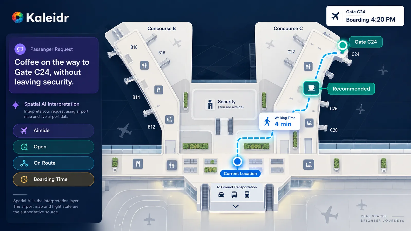
Airport Spatial AI should recommend places the passenger can actually use, not simply the closest pin.
Why Does an AI Airport Map Need Operational Systems?
A generic local-search assistant can list the nearest café around a pin. An airport product has to answer which place is currently usable given the passenger's security zone, open hours, lounge or other entitlement, walking time, and remaining time before boarding. Those answers depend on canonical place identity, zone containment, operating state, and trip context. A language model should not invent those fields from training memory.
Airports are dense decision environments: check-in, security, gates, concessions, lounges, restrooms, accessibility services, baggage claim, and ground transport all sit inside one constrained geography. SITA's Air Transport IT Insights 2025 — Airports reports that 63% of airports plan to increase IT spending, 60% already use AI in passenger-flow management, and 73% of airports — compared with 90% of airlines — are investing in AI for prediction and automation, with adoption taking hold in cybersecurity, passenger flow, and turnaround (SITA, 2025). Those figures describe operational investment, not a requirement that every terminal map become conversational. Natural-language interaction is useful when several constraints appear in one passenger question, alongside search, filters, and the map.
Kaleidr currently positions Travel as a Spatial AI vertical on the homepage (Kaleidr, 2026). ACI World's 2026 Airport Experience Summit likewise treated artificial intelligence, digital wayfinding, and real-time data as tools for more seamless and intuitive journeys (ACI World, 2026). The product opportunity is therefore not a second unofficial terminal directory. Location, access, and passenger intent still have to reduce friction without replacing the systems that already own gates, concessions, and flight state.
What Airport Data Should Ground Spatial AI?
The foundation is the airport place model, not the language model. An operator can define stable entities such as airport, terminal, concourse, security checkpoint, gate, lounge, restaurant, retail unit, restroom, service desk, baggage belt, and ground-transport stop. A concession or service then points at a place ID rather than at a free-text unit name. Stable identifiers allow the map, website, AI explanation, and analytics to refer to the same location after a rebrand, a gate reassignment, or a passenger nickname.
Source ownership should stay inspectable. Airport or facilities systems can own terminal geometry, zones, and concession locations. Airline or airport operations systems can own assigned gate, boarding time, and delay state. A tenant or hours source can own open status, and an entitlement source can own lounge access.
Geospatial services calculate walking time, route relationship, and whether a candidate sits on the path to the next gate. The AI layer owns request interpretation, clarification, explanation, and supported map actions. Grounded Spatial AI for Business Data sets the same boundary for authorized business inventory: the model explains grounded records; it does not become the system of record.
ACI World Insights argues that the same flight status, queue information, and gate guidance should appear consistently on the passenger's app, on terminal screens, and on staff handhelds (ACI World, 2026). An AI airport map should reuse that shared operational picture rather than invent a parallel one. How to Build a Map-Aware AI Assistant treats selected place, viewport, and active filters as load-bearing context, not decorative chat memory.
How Should Security Zones Filter Airport Search?
Start from the passenger job rather than from a decorative map. Typical jobs include finding a café that remains airside and still returns to the gate with a boarding buffer, reaching an entitled lounge before boarding, locating a restroom on the current concourse, or connecting from an arrival gate to a departure gate without an illegal zone crossing. Ordinary nearby search becomes misleading once zone, hours, and remaining time appear in one sentence. The AI layer is useful when it names the question airport systems should answer, not when it invents open-now status or boarding time.
Keep hard filters before spatial ranking. A nearby café is unusable if it sits landside after the passenger has cleared security, if it is closed, if lounge access is not entitled, or if the walk plus a dwell assumption consumes the remaining boarding buffer. The following comparison is editorial, not a documented Kaleidr schema. Real deployments should fill the same columns from the maps and operational feeds the host already publishes.
| Filter | Purpose | Typical owner |
|---|---|---|
| Security zone | Landside versus airside eligibility | Airport / facilities |
| Operating state | Open now, closed, or limited | Tenant / hours source |
| Entitlement | Lounge or other access rights | Airline / membership |
| Boarding buffer | Time to return to the gate | Airline operations + routing |
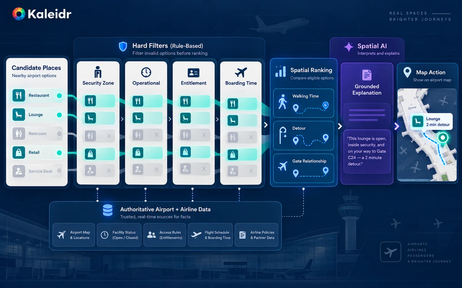
In an airport, eligibility comes before proximity: a nearby place is useless if the passenger cannot access it or return to the gate in time.
On-the-way ranking then uses walking time, added detour, and gate relationship among the surviving candidates. A restaurant that sits on the walk to Gate D18 can outrank a geographically closer option that requires a backward detour. AI Restaurant Search and Table Booking covers amenity ranking and booking handoff; airport search adds zone and boarding-time gates that a city restaurant map does not need. Indoor turn-by-turn navigation is optional and separate. AI Wayfinding Assistant for Venues already covers indoor routing and floor topology. Do not make those capabilities a prerequisite for a first airport map, and do not treat this article as a second wayfinding spec.
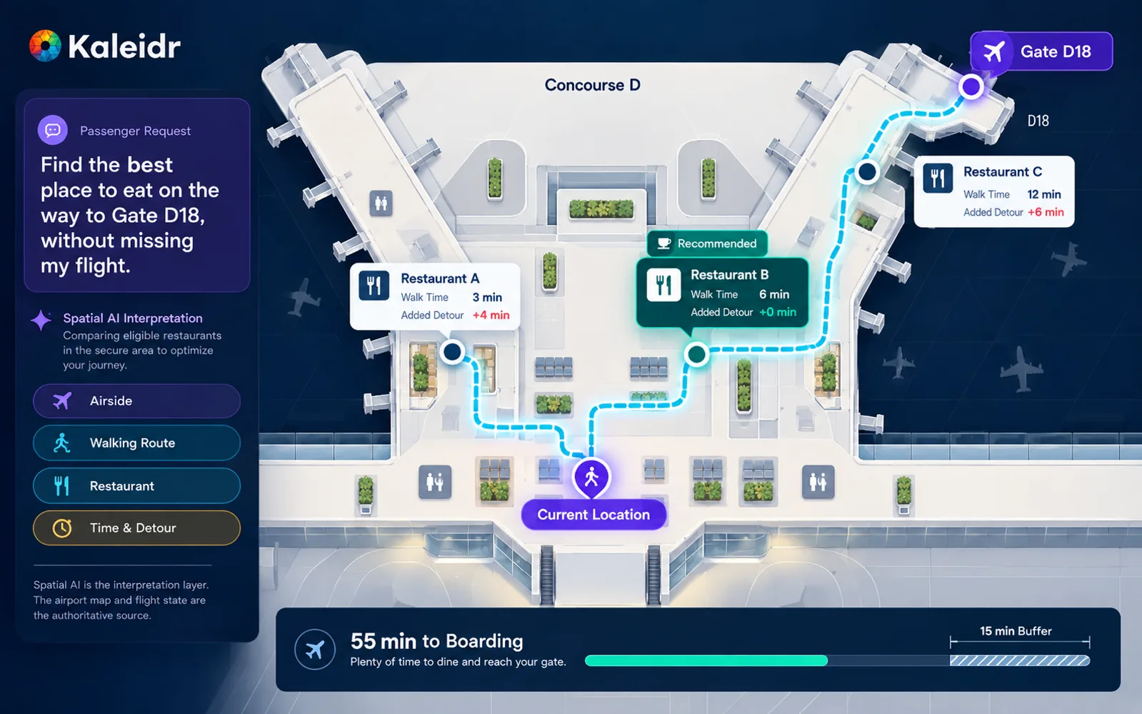
Airport recommendations should optimize the passenger's journey to the gate, not distance from a single point.
Supported actions can include focusing a place, showing a shortlist, showing a walking relationship, highlighting a zone, or opening an airport or airline service page. The host application validates each action. Avoid arbitrary JavaScript or unbounded map commands from the model.
Where Does Kaleidr Fit as a Conversational Layer?
The AI Map Chat for Customer Discovery page currently describes adding AI-powered search, recommendations, insights, and location-aware experiences to an existing map without rebuilding the host platform, including travel itineraries, routes, and destination recommendations. The Chat attach page documents product="chat" as a conversational layer over a map the host already renders, with auto-detection for Mapbox, MapLibre, and Google maps, plotting places onto that map as the conversation resolves locations (Kaleidr, 2026). The natural B2B pattern is an existing airport or airline website or app, map, and operational systems plus a Kaleidr conversational spatial layer, not a replacement of airport software.
The current public Platform API endpoints list includes SDK session exchange, streaming chat, route, POI enrichment, and design endpoints. The list does not currently publish dedicated flight-status, boarding-pass, security-queue, baggage-tracking, lounge-entitlement, or airport-operations routes. An airport article should not imply that Kaleidr replaces the AODB, airline PSS, concession system, or security-queue feed. Those remain host integrations unless a supported enterprise deployment states otherwise. The Location Intelligence APIs and Map SDK page currently describes SDKs, ranking, and analytics for spatial products. Depending on the configuration, Kaleidr can support a branded public wayfinding or amenity surface while authenticated itinerary actions still require host authorization.
The AI Map Maker for Branded Interactive Maps page currently describes Studio as a map-authoring surface for custom interactive maps, layers, datasets, branded tiles, 3D visualization, live data layers, and publishing. For airports, Studio can support branded terminal presentation, amenity overlays, and public destination layers. Use the host application and deeper integration where authenticated passenger context or complex operational systems are required. Kaleidr currently separates browser publishable keys from backend server keys on the Auth & scopes page. Keep passenger itinerary retrieval on the host backend.
How Should Teams Measure and Pilot an AI Airport Map?
Kaleidr Analytics currently documents map and place engagement, place comparison, spatial patterns, and activity that product, inventory, and growth teams can act on (Kaleidr, 2026). Host systems still own flights, queues, and entitlements. Use that loop to find amenities with high search demand and low successful resolution, concourses that generate no-result queries, and gates that attract last-minute food searches. SITA's airport research also notes that understanding how people move, dwell, and spend now drives commercial performance more than passenger counts alone (SITA, 2025). Spatial Analytics vs. Web Analytics covers why pageviews alone cannot answer those questions. Suggested event names in this article are editorial recommendations, not documented automatic Kaleidr Analytics event names.
Useful outcome measures include destination resolved, amenity selected, route opened, lounge selected, ground-transport opened, and no-result reason. A one-message success is often ideal. Do not optimize for messages per session. Privacy in airport analytics means aggregate zones and task outcomes, not named passenger trails or continuous movement histories. Precise indoor tracking is not required for the architecture in this article: a selected origin, current zone, flight context, and next gate can be enough.
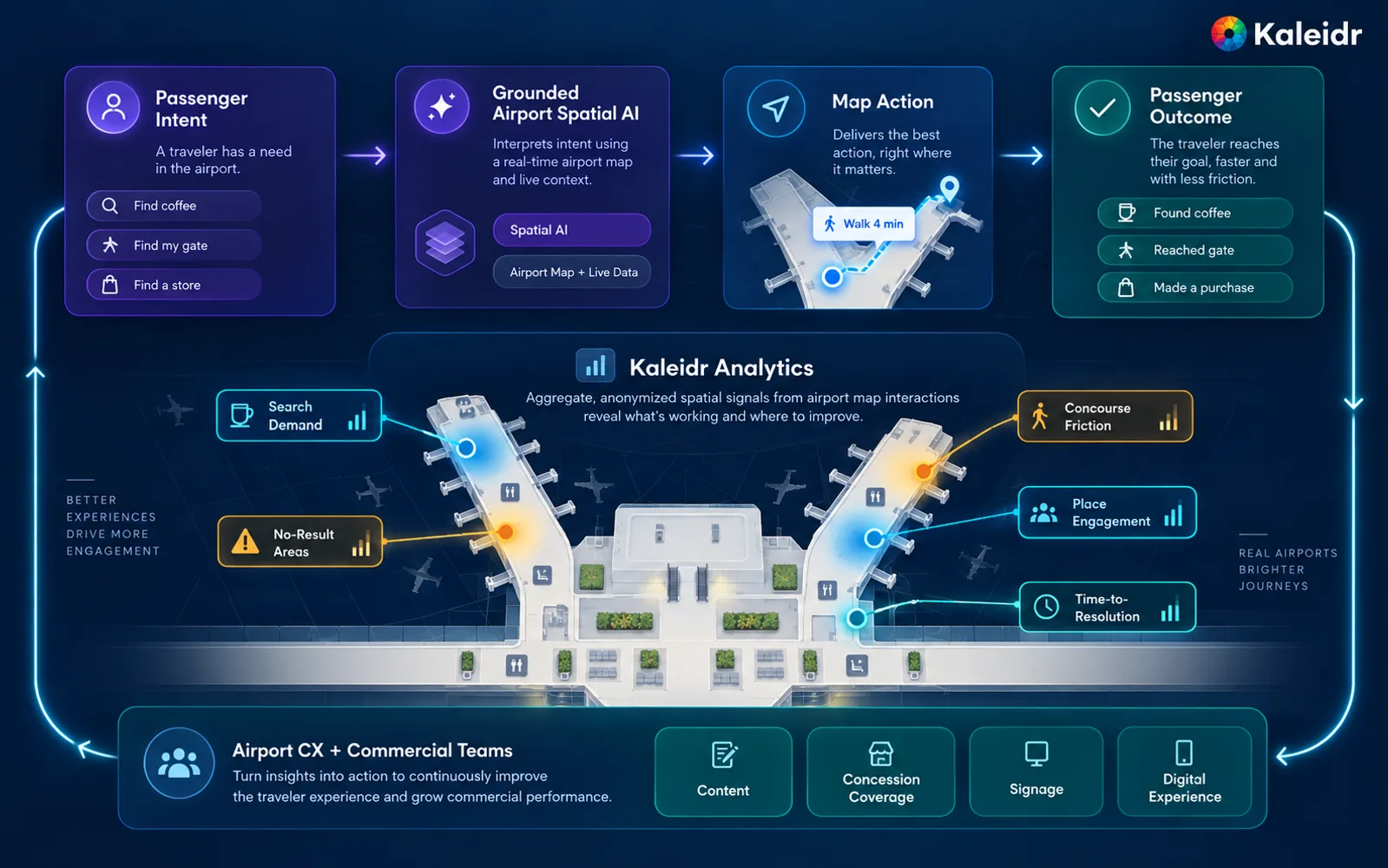
A passenger-facing AI map can also become a listening layer for airport customer experience when aggregate search and place engagement reveal where the journey breaks down.
Start with one terminal and one high-value task, such as helping airside passengers find a café that still returns to the gate. Keep identity, hours, entitlements, and flight records in the systems that already own them. Attach conversational map interaction to the existing map. Limit candidates to authorized public or role-visible places, require current zone and open state where the host can supply them, calculate walking relationship to the next gate, and measure destination resolution plus the airport or airline action that follows. Expand lounges, connections, accessibility, and authenticated itinerary context only when that first window works.
How Should an Airport Roll Out Spatial AI?
Review every new surface against zone eligibility, boarding-time feasibility, explanation grounding, mobile density, and empty-state behavior. Confirm that product amenities outrank decorative terminal geography, that marker and list or card state stay synchronized, and that a closed unit or no-result answer is visible rather than silent. Conversational map layers and host operational logic remain separate problems. Kaleidr authors and publishes the spatial conversation. The airport and airline still own gates, security, hours, and transactions.
Explore Kaleidr Enterprise to attach conversational Spatial AI to an existing airport or airline map. Explore Kaleidr Studio to author branded terminal layers and published map experiences. Confirm the current public pages before treating any example in this article as a shipping contract.
FAQs
What is an AI airport map?
An AI airport map combines a terminal map with natural-language interaction and structured airport context so passengers can find gates, amenities, lounges, services, and routes that fit their trip.
How is an AI airport map different from airport wayfinding?
Wayfinding focuses on how to reach a destination. Spatial AI can also help identify which destination is usable given the passenger's flight, security zone, boarding time, access, and preferences.
Should AI decide whether a passenger has time to visit a restaurant before boarding?
The language model can explain the result, but the feasibility calculation should use authoritative boarding time, walking-time data, activity assumptions, and an explicit safety buffer.
Can Spatial AI handle gate changes?
A gate change can update shared journey state and invalidate stale recommendations when the host supplies current gate state.
Can Kaleidr replace an airport's operational systems?
Airport and airline systems should remain authoritative for flights, gates, queues, access, baggage, and other operational state. Kaleidr can provide the conversational spatial layer around those systems.
Does Kaleidr provide a dedicated airport flight-status API?
The current public Platform API does not document a dedicated flight-status endpoint. Flight and airport operational data should come from the host or its authorized data providers.
Can Kaleidr attach to an existing airport map?
Current Kaleidr developer documentation supports attaching Chat to a compatible live Mapbox, MapLibre, or Google map the host already runs.
What should airports use as hard filters before ranking amenities?
Common hard filters include security zone, current operating status, entitlement, accessibility requirements when explicitly requested, and time feasibility before boarding.
Can an airport use Spatial AI for lounges?
The host can first determine which lounges the passenger can access, then use spatial and time context to rank the eligible options.
Can an AI airport map support ground transportation?
Ground transport can be treated as another airport place and journey layer, with host routing or mobility systems remaining authoritative for live travel information.
What should airports measure?
Useful metrics include question resolution, gate and amenity selection, route opens, no-result reasons, time-to-resolution, and aggregate search gaps by terminal or concourse.
Is airport passenger tracking required?
Many use cases can work with a selected origin, current terminal or zone, flight context, and next gate without storing a persistent precise movement history.
References
- Kaleidr. Build Your Own Spatial AI with Kaleidr. Accessed 17 September 2026. https://kaleidr.com/
- SITA. Air Transport IT Insights 2025 — Airports. Accessed 17 September 2026. https://www.sita.aero/resources/surveys-reports/air-transport-it-insights-2025/airports/
- Airports Council International World. Melbourne Airport to Host 2027 ACI World Airport Experience Summit — First Time in Oceania. 3 September 2026. https://aci.aero/2026/09/03/media-release-melbourne-airport-to-host-2027-aci-world-airport-experience-summit-first-time-in-oceania/
- Airports Council International World. Continuity is the New Seamless. Trust is the New UX. 4 June 2026, updated 8 July 2026. https://blog.aci.aero/customer-experience/airport-passenger-journey-continuity/
- Kaleidr. AI Map Chat for Customer Discovery. Accessed 17 September 2026. https://kaleidr.com/ai
- Kaleidr. Chat — attach AI to your map. Developer documentation. Accessed 17 September 2026. https://docs.kaleidr.com/sdk/chat-attach
- Kaleidr. Endpoints. Developer documentation. Accessed 17 September 2026. https://docs.kaleidr.com/platform-api/endpoints
- Kaleidr. Location Intelligence APIs and Map SDK. Accessed 17 September 2026. https://kaleidr.com/enterprise
- Kaleidr. AI Map Maker for Branded Interactive Maps. Accessed 17 September 2026. https://kaleidr.com/studio
- Kaleidr. Auth & scopes. Developer documentation. Accessed 17 September 2026. https://docs.kaleidr.com/platform-api/auth-and-scopes
- Kaleidr. Map Engagement and Location Analytics. Accessed 17 September 2026. https://kaleidr.com/analytics
- Kaleidr. AI Wayfinding Assistant for Venues. Accessed 17 September 2026. https://kaleidr.com/blog/ai-wayfinding-assistant
- Kaleidr. AI Restaurant Search and Table Booking. Accessed 17 September 2026. https://kaleidr.com/blog/ai-restaurant-search-table-booking
- Kaleidr. Grounded Spatial AI for Business Data. Accessed 17 September 2026. https://kaleidr.com/blog/grounded-spatial-ai-business-data
- Kaleidr. How to Build a Map-Aware AI Assistant. Accessed 17 September 2026. https://kaleidr.com/blog/how-to-build-a-map-aware-ai-assistant
- Kaleidr. Spatial Analytics vs. Web Analytics. Accessed 17 September 2026. https://kaleidr.com/blog/spatial-analytics-vs-web-analytics
@misc{kaleidr_airport_home_2026,
  title  = {Build Your Own Spatial AI with Kaleidr},
  author = {{Kaleidr}},
  year   = {2026},
  note   = {Accessed 17 September 2026},
  url    = {https://kaleidr.com/}
}

@misc{sita_airport_it_insights_2025,
  title  = {Air Transport IT Insights 2025 -- Airports},
  author = {{SITA}},
  year   = {2025},
  note   = {Accessed 17 September 2026},
  url    = {https://www.sita.aero/resources/surveys-reports/air-transport-it-insights-2025/airports/}
}

@misc{aci_airport_experience_2026,
  title  = {Melbourne Airport to Host 2027 ACI World Airport Experience Summit -- First Time in Oceania},
  author = {{Airports Council International World}},
  year   = {2026},
  month  = sep,
  note   = {Accessed 17 September 2026},
  url    = {https://aci.aero/2026/09/03/media-release-melbourne-airport-to-host-2027-aci-world-airport-experience-summit-first-time-in-oceania/}
}

@misc{aci_journey_continuity_2026,
  title  = {Continuity is the New Seamless. Trust is the New UX},
  author = {{Airports Council International World}},
  year   = {2026},
  month  = jun,
  note   = {Published 4 June 2026, updated 8 July 2026; accessed 17 September 2026},
  url    = {https://blog.aci.aero/customer-experience/airport-passenger-journey-continuity/}
}

@misc{kaleidr_airport_ai_2026,
  title  = {AI Map Chat for Customer Discovery},
  author = {{Kaleidr}},
  year   = {2026},
  note   = {Accessed 17 September 2026},
  url    = {https://kaleidr.com/ai}
}

@misc{kaleidr_airport_chat_attach_2026,
  title  = {Chat -- attach AI to your map},
  author = {{Kaleidr}},
  year   = {2026},
  note   = {Developer documentation; accessed 17 September 2026},
  url    = {https://docs.kaleidr.com/sdk/chat-attach}
}

@misc{kaleidr_airport_endpoints_2026,
  title  = {Endpoints},
  author = {{Kaleidr}},
  year   = {2026},
  note   = {Developer documentation; accessed 17 September 2026},
  url    = {https://docs.kaleidr.com/platform-api/endpoints}
}

@misc{kaleidr_airport_enterprise_2026,
  title  = {Location Intelligence APIs and Map SDK},
  author = {{Kaleidr}},
  year   = {2026},
  note   = {Accessed 17 September 2026},
  url    = {https://kaleidr.com/enterprise}
}

@misc{kaleidr_airport_studio_2026,
  title  = {AI Map Maker for Branded Interactive Maps},
  author = {{Kaleidr}},
  year   = {2026},
  note   = {Accessed 17 September 2026},
  url    = {https://kaleidr.com/studio}
}

@misc{kaleidr_airport_auth_2026,
  title  = {Auth \& scopes},
  author = {{Kaleidr}},
  year   = {2026},
  note   = {Developer documentation; accessed 17 September 2026},
  url    = {https://docs.kaleidr.com/platform-api/auth-and-scopes}
}

@misc{kaleidr_airport_analytics_2026,
  title  = {Map Engagement and Location Analytics},
  author = {{Kaleidr}},
  year   = {2026},
  note   = {Accessed 17 September 2026},
  url    = {https://kaleidr.com/analytics}
}

@misc{kaleidr_airport_wayfinding_2026,
  title  = {AI Wayfinding Assistant for Venues},
  author = {{Kaleidr}},
  year   = {2026},
  note   = {Accessed 17 September 2026},
  url    = {https://kaleidr.com/blog/ai-wayfinding-assistant}
}

@misc{kaleidr_airport_restaurant_2026,
  title  = {AI Restaurant Search and Table Booking},
  author = {{Kaleidr}},
  year   = {2026},
  note   = {Accessed 17 September 2026},
  url    = {https://kaleidr.com/blog/ai-restaurant-search-table-booking}
}

@misc{kaleidr_airport_grounded_2026,
  title  = {Grounded Spatial AI for Business Data},
  author = {{Kaleidr}},
  year   = {2026},
  note   = {Accessed 17 September 2026},
  url    = {https://kaleidr.com/blog/grounded-spatial-ai-business-data}
}

@misc{kaleidr_airport_map_aware_2026,
  title  = {How to Build a Map-Aware AI Assistant},
  author = {{Kaleidr}},
  year   = {2026},
  note   = {Accessed 17 September 2026},
  url    = {https://kaleidr.com/blog/how-to-build-a-map-aware-ai-assistant}
}

@misc{kaleidr_airport_spatial_analytics_2026,
  title  = {Spatial Analytics vs. Web Analytics},
  author = {{Kaleidr}},
  year   = {2026},
  note   = {Accessed 17 September 2026},
  url    = {https://kaleidr.com/blog/spatial-analytics-vs-web-analytics}
}