
A 3D map is useful when vertical form changes how someone understands a place. Terrain can reveal slope, extruded buildings can show urban mass, and a pitched camera can clarify relationships that flatten in 2D. Depth is not automatically better: a product should add it only when the third dimension improves a real decision. Kaleidr Studio currently documents 3D terrain, real elevation, hillshade, and extruded buildings alongside custom basemaps, layers, live data, and publishing.
The sections below cover when depth helps, Studio’s current public 3D contract, terrain versus hillshade versus extrusion, authoritative elevation and height data, camera and label design, authoring workflow, and failure modes. Related reading includes How to Build a Custom Branded Basemap, AI Interactive Map Builder, Map Publishing Guide, How to Embed an Interactive Map, and Digital Mapping. Teams that already know the product decision can skip to the Studio contract and the authoring sequence; teams still choosing between 2D and depth should start with the decision tests.
3D map essentials
- Depth has to change the decision: Terrain, elevation, or building mass should answer a question a flat map leaves obscure.
- Hillshade is not terrain: Shading can show relief while the surface stays flat; pitched terrain changes geometry.
- Elevation and height stay authoritative: Visual realism is not proof of measured accuracy.
- Business layers stay on top: Properties, stores, assets, and service areas remain the primary information.
- Confirm the product contract: Studio documents terrain, hillshade, and extruded buildings, not arbitrary 3D-model import.
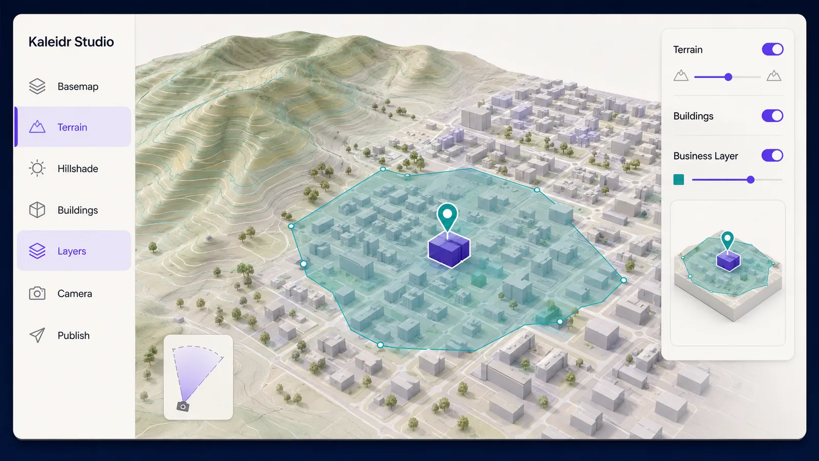
What Is a 3D Map?
A 3D map represents vertical spatial information with elevation, terrain, perspective, extruded buildings, or other three-dimensional geometry. Many web products described as 3D are 2.5D: a pitched camera, a terrain surface, and extruded polygons rather than a full scene of arbitrary meshes, custom lighting, and object-level interaction. That controlled depth is often enough for property, tourism, infrastructure, and city-context maps. A full 3D scene can wait until the product actually needs custom models.
The useful test is whether vertical form changes the user’s task. Slope can decide a route or a construction method. Surrounding building mass can change how a listing reads. Landscape character can change how a destination is understood before arrival. If the third dimension does not improve those answers, a digital mapping product should stay flatter. Decorative pitch is not a product capability.
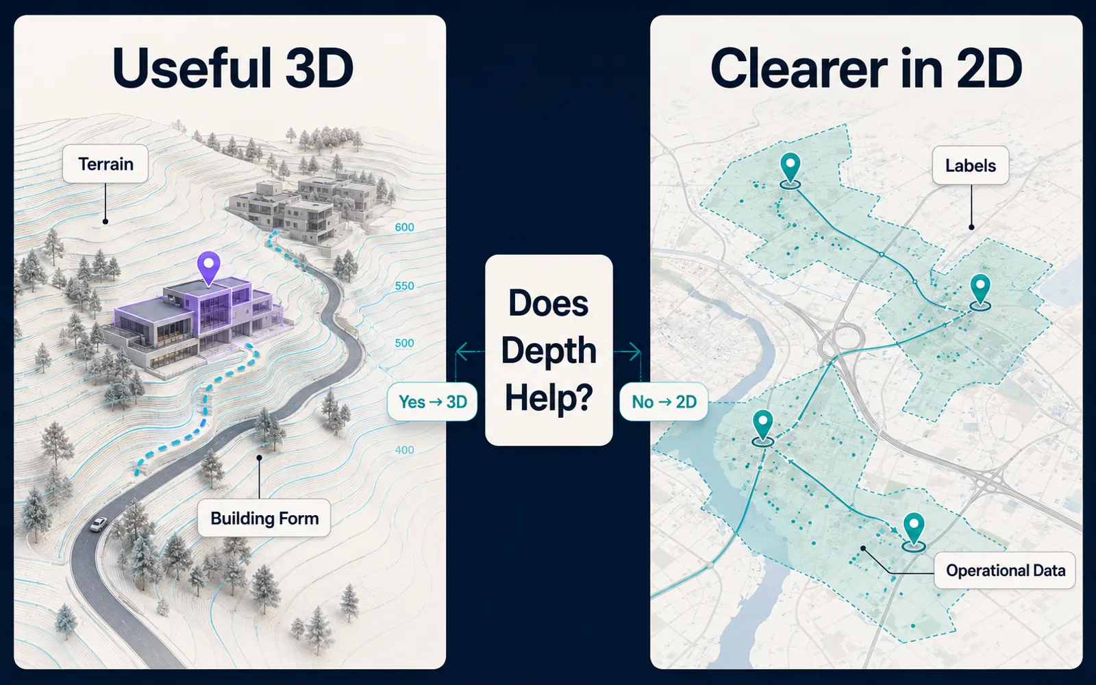
When Does a 3D Map Improve a Product Decision?
The wrong reason to add depth is visual impressiveness. The better question is what becomes easier to understand when the map has depth. Terrain helps when a route, site, or asset sits on slope, ridge, or elevation change. Extruded buildings help when urban density, height, and block structure are part of the decision. A pitched camera helps only when those relationships remain readable after labels, markers, and overlays compete for the same pixels.
Terrain is often valuable for outdoor tourism, hillside property, infrastructure, and elevation-sensitive logistics. Extruded buildings can help real estate, development, architecture, campus maps, and city storytelling by showing selected places against surrounding mass. Dense operational locators, simple store search, and mobile-first finders often stay clearer in 2D because markers, labels, and service areas remain unoccluded. Use the lowest amount of depth that communicates the needed form.
| Need | Recommended approach |
|---|---|
| Show slope or landscape | Terrain and hillshade |
| Add subtle terrain context | Hillshade first |
| Show urban massing | Building extrusion |
| Highlight business polygons | 2D first; extrude only if height adds meaning |
| Tell a visual story | Moderate pitch and a controlled camera |
| Dense operational dashboard | Restrained 2D or 2.5D |
| Mobile-first locator | Low pitch or 2D |
| High-end property or tourism experience | 3D can be valuable |
| Precise spatial measurement | Analytics, not visual depth |
What 3D Capabilities Does Kaleidr Studio Currently Document?
Kaleidr Studio currently lists 3D Visualization among its Studio advantages and says teams can “Add 3D terrain, real elevation, and extruded buildings so audiences read any landscape at a glance” (AI Map Maker for Branded Interactive Maps). The same page lists hillshade beside elevation and 3D buildings, and states that “Terrain, hillshade, and extruded buildings are built from real elevation data.” That copy is authoritative about Kaleidr’s own positioning. The architecture below treats those four surfaces as the public contract and does not invent an import path the page does not describe.
Studio places that 3D visualization in the same environment as custom map tiles, branded basemaps, live data layers, reusable layers and datasets, and publishing. A 3D experience should still follow the same custom branded basemap hierarchy as the rest of the product: land, roads, labels, selected state, then business overlays. Depth that looks like a generic terrain renderer dropped into an otherwise branded map is a design failure even when the elevation source is real.
Studio’s FAQ currently says maps can be published as a standalone page or embedded as a widget. Prompt-first authoring can shorten the distance from an idea to a designed map, as in the AI interactive map builder workflow. The language model can help request or arrange a visualization; elevation, building height, and business data remain sources of truth. Do not treat a rendered screenshot as a measurement.
How Should Terrain, Hillshade, and Buildings Differ?
Terrain changes the rendered surface according to elevation, so the map is no longer a flat plane. Hillshade simulates light and shadow across elevation so relief is easier to perceive; a map can use hillshade without a fully pitched terrain experience. Extruded buildings give footprint polygons height so they rise from the map. Any polygon with a meaningful numeric value could be extruded, but not every numeric field should become a 3D column. Sales, capacity, or intensity as height only helps when users can read the scale, compare features, and recover the same fact as text.
MapLibre GL JS currently shows elevation as actual 3D through a raster-dem source, a terrain style block, hillshade, and a TerrainControl (3D Terrain). The example’s own heading is “Go beyond hillshade and show elevation in actual 3D,” which is the same distinction a product designer should keep. The MapLibre Style Spec defines terrain exaggeration as an optional number that defaults to 1 and describes how high the terrain will look (Terrain). Exaggeration can make subtle relief easier to see. If used where accuracy matters, disclose it, avoid treating the scene as a measurement surface, and keep settings consistent across comparisons.
Hillshade can be enough for print-like editorial maps, broad regional views, maps with many labels, and lower-powered devices. Terrain plus hillshade can work together: geometry supplies relief, shading supplies visual cues. Keep shading from overpowering roads, boundaries, or business layers. For ordinary city store search, terrain often adds little.
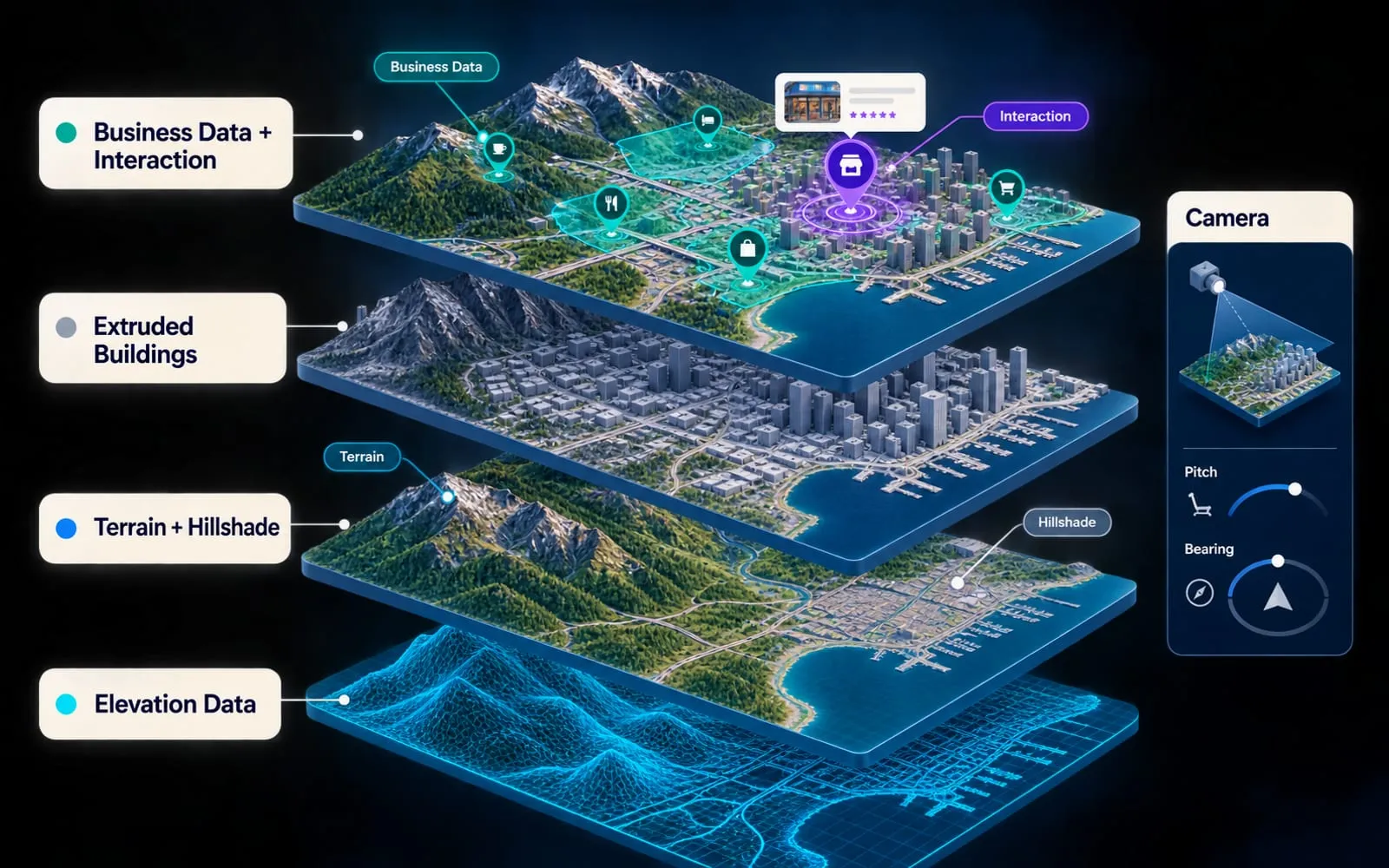
Why Must Elevation and Height Data Stay Authoritative?
A 3D terrain map needs elevation data. Terrain geometry comes from that source, not from a language model inventing hills. MapLibre’s building example uses a fill-extrusion layer driven by building-height attributes such as render_height and render_min_height (Display buildings in 3D). Mapbox documents the same style pattern: include 3D buildings in a style, including by creating a fill-extrusion layer from building source data (3D buildings in a Mapbox Style). Those pages are evidence of how web maps extrude footprints. The MapLibre and Mapbox documents are not Kaleidr Studio’s authoring UI, and they do not make missing height values exact.
Beautiful extrusion can create a strong impression of precision. Ask whether the elevation source is current, whether building heights are measured or estimated, whether coverage is complete, whether vertical units are consistent, and whether missing values are obvious. If height data is absent, the product should not pretend every building has an exact real-world height. A 3D map can make patterns easier to perceive; it does not automatically quantify average elevation, area, slope, distance, or building count. Use deterministic analytics for those questions. A Studio map is a product-facing interactive experience, not a replacement for GIS preprocessing, terrain analysis, or data QA.
MapLibre currently documents custom 3D layers that place models on terrain with three.js (Adding 3D models using three.js on terrain). The three.js example is useful background for teams that later need landmarks, equipment, or architectural models in an application they control. Kaleidr Studio’s current public page specifically documents terrain, hillshade, and extruded buildings—not a universal GLTF, OBJ, 3D Tiles, or mesh import workflow. Confirm the supported Studio or Enterprise path before planning around custom assets.
How Should Camera, Labels, and Business Layers Work Together?
A 3D map depends on pitch, bearing, zoom, and center as much as on geometry. Low pitch stays close to 2D and favors overview, labels, and familiar interaction. Moderate pitch makes terrain or building mass visible without losing orientation. High pitch can create dramatic depth while increasing occlusion, distortion, and interaction difficulty. Use the lowest pitch that communicates the needed depth. A promotional map can open on an intentional camera; a product map should let the user recover orientation with reset north, reset pitch, zoom, and return to the selected place.
Labels become harder once extrusions and terrain occupy the same view, because overlap, reduced contrast, orientation confusion, and depth ambiguity all increase. Keep the hierarchy restrained: selected destinations, important business places, major geographic reference, then secondary context, rather than displaying every possible label. The most important layer is usually the business information—properties, stores, assets, event locations, service areas, live incidents—not the terrain. Terrain and buildings are contextual background; the business layer is primary information; and the selected state is the strongest visual emphasis.
Dense 3D buildings can hide markers, routes, labels, and polygons behind taller geometry, especially at aggressive pitches. Reduce extrusion opacity, simplify building styling, lower pitch, keep overlays readable, and offer a 2D toggle when the core task is operational. Brand colors still matter in 3D, but a monochromatic treatment can flatten hierarchy even when the geometry is technically three-dimensional. Terrain needs visual depth; buildings need separation from business overlays; selected-state accents need to win.
W3C Web Content Accessibility Guidelines (WCAG) 2.2, a Recommendation dated 12 December 2024, includes Success Criterion 1.3.3 Sensory Characteristics: instructions for understanding and operating content must not rely solely on sensory characteristics such as shape, color, size, visual location, orientation, or sound. Height-as-inventory, color-as-status, or pitch-as-importance therefore needs a text, list, legend, or tooltip equivalent. Success Criterion 2.3.3 Animation from Interactions (Level AAA) says motion animation triggered by interaction can be disabled unless the animation is essential. Restrained camera transitions can help a user move from overview to a selected property; constant flyovers can cause disorientation and motion discomfort. The core task should remain available as a list, keyboard-accessible controls, clear labels, and non-visual descriptions.
How Should Teams Author a 3D Map in Kaleidr Studio?
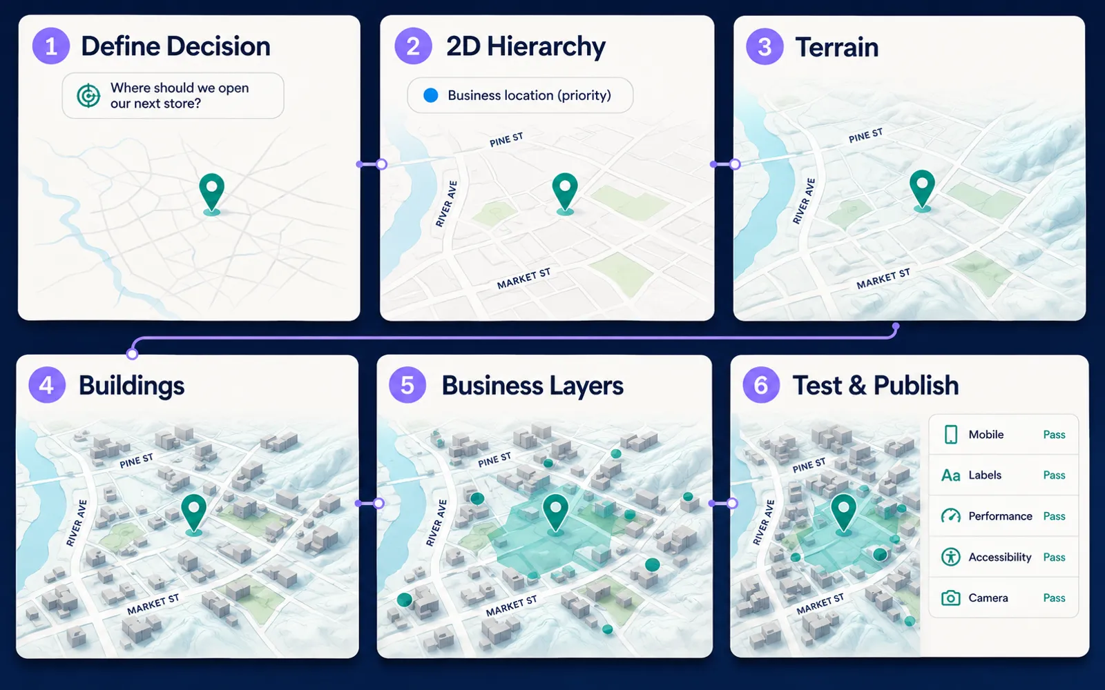
Design the 2D hierarchy first. If roads are unreadable, business data is unclear, labels are unprioritized, or the selected state is weak while the map is flat, depth will amplify the problem rather than fix it. Choose geographic extent, establish the basemap, then add elevation or hillshade, then buildings if they help, then business overlays, then camera, then tests for labels, selection, performance, and publish behavior. Map publishing still distinguishes a draft from a consumption surface. A Studio preview on a strong desktop is not a production test.
Property maps are among the strongest 3D uses: listing plus surrounding building mass, terrain, nearby amenities, and road context. Tourism maps can use terrain for mountain regions, coastlines, viewpoints, and scenic routes, as in an AI-powered tourism map, without sacrificing place names or accessible controls. Infrastructure maps can combine terrain with assets, service areas, incidents, and inspection status while keeping asset state primary. Studio currently lists both real-time layers and 3D visualization on the same page. The combination can help terrain-sensitive tracking, but rendering cost rises. Use depth only when it helps interpret the live state; do not animate thousands of moving assets over a complex scene merely because both features are available.
Performance can increase GPU workload, memory, tile demand, scene complexity, and battery use, so teams should test older phones, integrated laptop GPUs, mobile browsers, and large displays. Measure startup, frame rate, interaction responsiveness, memory, and device heat where relevant. Progressive enhancement is a product choice: capable devices can receive terrain and buildings; limited devices can receive hillshade or 2D, and the core task should remain usable either way. On mobile, high pitch reduces visible area, fingers can obscure the scene, popups compete with buildings, and rotation can disorient users, so lower default pitch, strengthen reset, enlarge selected markers, and keep north orientation obvious.
A share link is useful when the map can stand alone or needs a fast review surface. An embed is useful when surrounding content explains context or business actions sit outside the map; see how to embed an interactive map. The 3D scene should fit the host page rather than dominate it. A marketing map may emphasize first impression. A product map should emphasize orientation, interaction, readable labels, stable controls, and performance. The same Studio map can need different defaults depending on the audience.
What Failure Modes Should 3D Map Products Avoid?
The recurring failure is turning on 3D because it looks impressive rather than because vertical form changes a decision. High pitch then hides labels, buildings overpower business data, and every numeric polygon becomes a column. Rendered height is treated as exact truth, arbitrary 3D models are assumed without a documented Studio path, and every device is forced into the same scene. The camera never rests, meaning lives only in perspective, and the 2D hierarchy was never designed.
| Mistake | Result | Better approach |
|---|---|---|
| Add 3D because it looks impressive | The product becomes decorative | Tie depth to a user decision |
| Use high pitch everywhere | Labels and markers disappear | Use moderate pitch |
| Treat rendered height as exact truth | Visual precision is overstated | Document the data source |
| Extrude every numeric polygon | The scene becomes unreadable | Use height only when meaningful |
| Let buildings overpower business data | The core task is hidden | Keep overlays visually dominant |
| Use 3D on every device | Performance suffers | Progressive enhancement |
| Add arbitrary 3D models without support | Integration assumptions break | Confirm current product capabilities |
| Animate the camera constantly | The user loses orientation | Use restrained transitions |
| Rely on perspective only | Accessibility weakens | Add text and labels |
| Skip 2D design | 3D amplifies poor hierarchy | Design flat first |
Spatial AI can help users ask which properties sit higher on a site, which facilities are closest to a ridge, or which buildings surround a venue. The application should translate that intent into a structured spatial query against authoritative elevation and building data, then explain and move the map. Do not infer exact elevation by inspecting a rendered image. The language model authors and explains; geospatial services and business datasets remain the facts.
Build a 3D Map in Kaleidr Studio
A production 3D map in Kaleidr Studio starts from the decision the user must make, then designs the 2D hierarchy before adding only the depth that improves that decision. Business data stays visually dominant, the camera stays recoverable, and performance plus accessibility are tested before publish or embed. Explore Kaleidr Studio for current terrain, elevation, hillshade, extruded-building, basemap, and publishing surfaces. Confirm the Studio contract before encoding a custom 3D-model path that the public page does not document.
FAQs
What is a 3D map?
A 3D map represents vertical spatial information using terrain elevation, perspective, extruded buildings, or other three-dimensional geometry.
When is a 3D map better than a 2D map?
A 3D map is better when elevation, slope, building mass, or vertical relationships materially improve the user's understanding. For simple location search or dense operational interfaces, 2D may be clearer.
What 3D capabilities does Kaleidr Studio currently describe?
Kaleidr Studio currently documents 3D terrain, real elevation, hillshade, and extruded buildings.
Does Kaleidr Studio support real elevation data?
The current Studio page says terrain, hillshade, and extruded buildings are built from real elevation data.
Is hillshade the same as 3D terrain?
No. Hillshade visually simulates relief from elevation, while 3D terrain changes the rendered surface geometry.
How are 3D buildings created on web maps?
A common implementation extrudes building footprints using height and base-height attributes. MapLibre GL JS, for example, supports building extrusion through style layers.
Does Kaleidr Studio support arbitrary 3D model uploads?
The current public Studio page documents terrain, hillshade, and extruded buildings but does not describe a universal arbitrary 3D-model import workflow. Confirm the supported integration before planning around custom models.
Can 3D maps hurt performance?
Yes. Terrain, building geometry, 3D models, high pitch, and large datasets can increase GPU, memory, network, and battery use.
Should a 3D map use a high camera pitch?
Not automatically. Use the lowest pitch that communicates the needed depth while preserving labels, orientation, and interaction.
Can spatial AI work with 3D maps?
Yes conceptually. A language model can interpret questions involving terrain or building context, but the underlying elevation, geometry, and spatial calculations should come from structured geographic data.
Can I publish a 3D map made in Kaleidr Studio?
Kaleidr Studio currently supports publishing and embedding map experiences. Test the 3D scene across devices before production.
References
- Kaleidr. AI Map Maker for Branded Interactive Maps. Accessed 30 August 2026. https://kaleidr.com/studio
- Mapbox. 3D buildings in a Mapbox Style. Accessed 30 August 2026. https://docs.mapbox.com/help/dive-deeper/z_add-3d-buildings-studio/
- MapLibre GL JS. 3D Terrain. Accessed 30 August 2026. https://maplibre.org/maplibre-gl-js/docs/examples/3d-terrain/
- MapLibre GL JS. Adding 3D models using three.js on terrain. Accessed 30 August 2026. https://maplibre.org/maplibre-gl-js/docs/examples/adding-3d-models-using-threejs-on-terrain/
- MapLibre GL JS. Display buildings in 3D. Accessed 30 August 2026. https://maplibre.org/maplibre-gl-js/docs/examples/display-buildings-in-3d/
- MapLibre Style Spec. Terrain. Accessed 30 August 2026. https://maplibre.org/maplibre-style-spec/terrain/
- W3C. Web Content Accessibility Guidelines (WCAG) 2.2. W3C Recommendation, 12 December 2024. Accessed 30 August 2026. https://www.w3.org/TR/WCAG22/
@misc{kaleidr_studio_3d_2026_08_30,
  title  = {AI Map Maker for Branded Interactive Maps},
  author = {{Kaleidr}},
  note   = {Accessed 30 August 2026},
  url    = {https://kaleidr.com/studio}
}

@misc{mapbox_3d_buildings_style_2026_08_30,
  title  = {3D buildings in a Mapbox Style},
  author = {{Mapbox}},
  note   = {Accessed 30 August 2026},
  url    = {https://docs.mapbox.com/help/dive-deeper/z_add-3d-buildings-studio/}
}

@misc{maplibre_3d_terrain_2026_08_30,
  title  = {3D Terrain},
  author = {{MapLibre GL JS}},
  note   = {Accessed 30 August 2026},
  url    = {https://maplibre.org/maplibre-gl-js/docs/examples/3d-terrain/}
}

@misc{maplibre_threejs_terrain_2026_08_30,
  title  = {Adding 3D models using three.js on terrain},
  author = {{MapLibre GL JS}},
  note   = {Accessed 30 August 2026},
  url    = {https://maplibre.org/maplibre-gl-js/docs/examples/adding-3d-models-using-threejs-on-terrain/}
}

@misc{maplibre_display_buildings_3d_2026_08_30,
  title  = {Display buildings in 3D},
  author = {{MapLibre GL JS}},
  note   = {Accessed 30 August 2026},
  url    = {https://maplibre.org/maplibre-gl-js/docs/examples/display-buildings-in-3d/}
}

@misc{maplibre_style_spec_terrain_2026_08_30,
  title  = {Terrain},
  author = {{MapLibre Style Spec}},
  note   = {Accessed 30 August 2026},
  url    = {https://maplibre.org/maplibre-style-spec/terrain/}
}

@techreport{w3c_wcag22_2024,
  title       = {Web Content Accessibility Guidelines (WCAG) 2.2},
  author      = {{W3C}},
  institution = {W3C},
  year        = {2024},
  month       = dec,
  note        = {W3C Recommendation, 12 December 2024; accessed 30 August 2026},
  url         = {https://www.w3.org/TR/WCAG22/}
}