
Branded interactive maps should feel like part of the product around them, not like a third-party widget dropped onto the page. A map design system defines reusable rules for hierarchy, typography, labels, icons, overlays, selection, and publishing so many maps share one visual language. Kaleidr Studio currently supports custom basemaps, reusable layers and presets, 3D visualization, live data layers, and publishing (Kaleidr, 2026).
The sections below separate reference geography from product data, then cover semantic roles, presets, interaction states, testing, publishing, and measurement. Related reading includes How to Build a Custom Branded Basemap, AI Interactive Map Builder: Prompt to Publish, 3D Maps in Kaleidr Studio, and Map Publishing Guide. The rest of the article is written for teams that will publish several maps and need one visual system, not for teams styling a single screenshot.
Map design-system essentials
- Job first: Decide what the map should help someone choose before assigning colors.
- Reference recedes: Land, water, and roads orient; business data and selected states decide.
- Roles, not hex dumps: Semantic map roles scale better than restyling every layer by hand.
- Presets follow jobs: Customer discovery and operational monitoring reuse the same system with different density.
- Tokens are governance: Semantic names are a review practice, not a documented Studio import API.
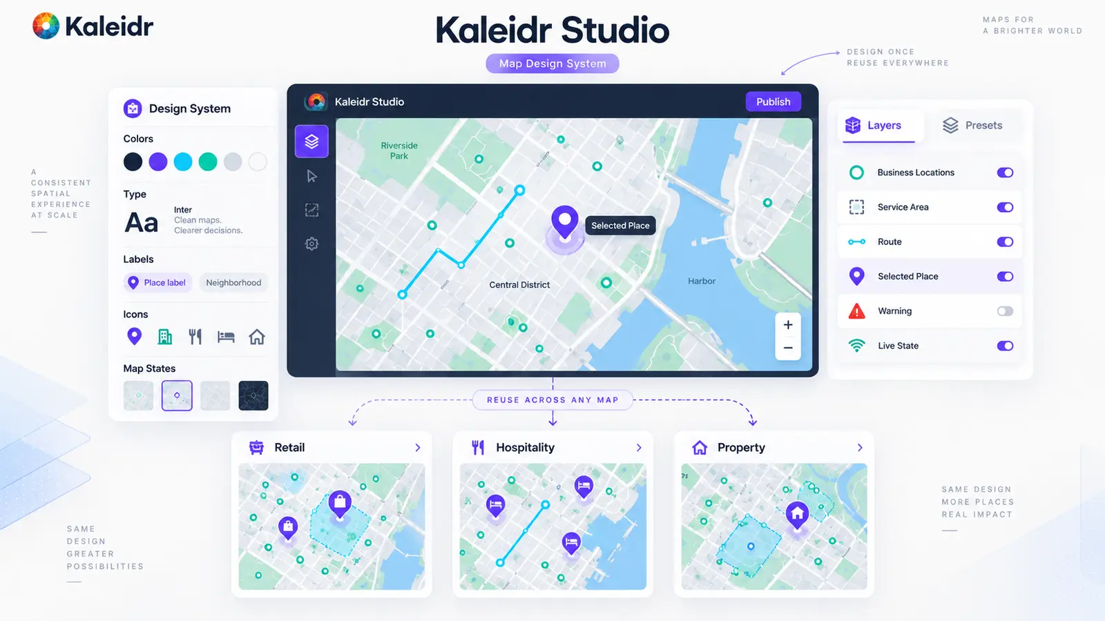
A map design system turns one visual language into many consistent interactive maps.
Why Do Branded Interactive Maps Need a Design System?
A common first attempt is to push the marketing palette onto roads, water, markers, and the selected state. The result can look branded and still be hard to read, because a map carries several information roles at once: reference geography, business locations, routes, search areas, alerts, labels, and live state. A product palette was not necessarily designed for dense geographic information. Brand identity should guide the map; color still has to follow function.
A map design system is the reusable rule set, not the finished map. The same system can cover a store locator, a property-search experience, a tourism guide, a venue map, an operations dashboard, and an embedded product map. The data can change. The visual logic should remain recognizable. Without that system, Map A gets a slightly different selected marker, Map B gets a different road hierarchy, and Map C gets a different alert color until the product no longer looks like one company.
How to Build a Custom Branded Basemap covers the geographic canvas: land, water, roads, labels, and tiles. AI Interactive Map Builder: Prompt to Publish covers creating and publishing one map from a concept. The map-system article covers overlays, selection, presets, testing, and reuse across many maps.
Where Does Kaleidr Studio Fit as an Authoring Layer?
The AI Map Maker for Branded Interactive Maps page currently describes creating custom interactive maps with Kaleidr AI, then editing styles, layers, locations, content, and interactive experiences. The same page documents custom map tiles and branded basemaps; control over colors, typography, labels, and icons; reusable layers, overlays, datasets, and style presets that can be saved and reapplied; 3D terrain, real elevation, hillshade, and extruded buildings; live data layers that update as the underlying feed changes; and publishing tiles to maps and apps. Studio is therefore a natural place to treat map design as a reusable system rather than a one-off styling pass.
Studio does not currently document a dedicated design-token import API or a tokens.json schema. Semantic roles in this article are an editorial governance practice for how teams author and review maps. Host applications still own business data, permissions, and transactions. No-Code Map Builder vs. Map API covers when authoring should stay in Studio and when a product needs a deeper integration path.
Kaleidr currently publishes map website templates from the template store (Kaleidr, 2026). Studio can supply the authored map and visual system. The template supplies surrounding page structure. Teams can keep map identity consistent even when the page layout changes. Confirm the live template catalog before treating any layout name as a shipping contract.
How Should Reference Geography Stay Separate From Product Data?
Start from the product job. A retail map should make the right store obvious. A hospitality map should make the next amenity or nearby experience obvious. A property map should make the listing that fits the search criteria obvious. An operations map should make the live asset or region that needs attention obvious. If every feature is equally strong, the map has no hierarchy.
Reference geography provides orientation: land, water, roads, boundaries, place labels, buildings, and terrain. Product data supports the decision: stores, properties, hotels, venues, assets, service areas, routes, and alerts. The reference map should usually recede. Product data should usually dominate. A useful stack then runs background, reference geography, business context, interactive overlays, selected state, and critical state, with the strongest state identifiable immediately.
The MapLibre Style Specification draws a related technical line: sources define the data a map can display, while layers define how that data is rendered (MapLibre, 2026). One store dataset can therefore feed default markers, a selected-place layer, and a label layer without flattening every record into one pin style. Teams working in Studio rather than in style JSON can still keep that source-versus-layer distinction in the design review.
The following comparison is editorial, not a documented Kaleidr schema. Real deployments should fill the same columns from the maps the host already publishes.
| Layer | Purpose | Visual priority |
|---|---|---|
| Reference roads | Orientation | Low |
| Service area | Eligibility context | Medium |
| Business locations | Main results | High |
| Route | Current journey | High |
| Selected place | Current focus | Very high |
| Alert | Requires attention | Very high |

Reference geography should orient the user; product data and selected states should drive the decision.
What Semantic Roles and Presets Should a Map System Use?
Do not begin by assigning the brand's primary color to every map element. Begin with roles such as land, water, primary road, primary label, business default, business selected, route, search area, warning, and unavailable, then assign brand-compatible colors to those roles. If the company later changes its primary brand color, a shared map.business.selected role can move every map consistently, while fifty maps carrying thirty hand-tuned layer rules each have to be restyled one at a time.
Reusable presets reduce drift. The Studio page currently describes saving overlays and presets once, then reapplying them across maps instead of restyling each map by hand. Name presets after the job, not after an internal team: Customer Discovery, Property Search, Operational Monitoring, Destination Guide, and Live Asset Tracking are easier to reuse than Marketing Map v3. Semantic roles stay consistent. Density, camera, and which layers are on can still change with the task.
A company may also need a basemap family — light, dark, editorial, operational, presentation — that still feels related. Shared rules can cover typography, road hierarchy, selected accent, water treatment, label logic, and icon vocabulary. A dark map is not an inverted light map. Contrast, label halos, road casing, overlay brightness, and warning treatment all change while the role names stay put. Strong brand accents belong on selected locations, primary routes, active search areas, and the current customer action. If the same accent paints roads, water, labels, markers, and buttons, nothing feels important.
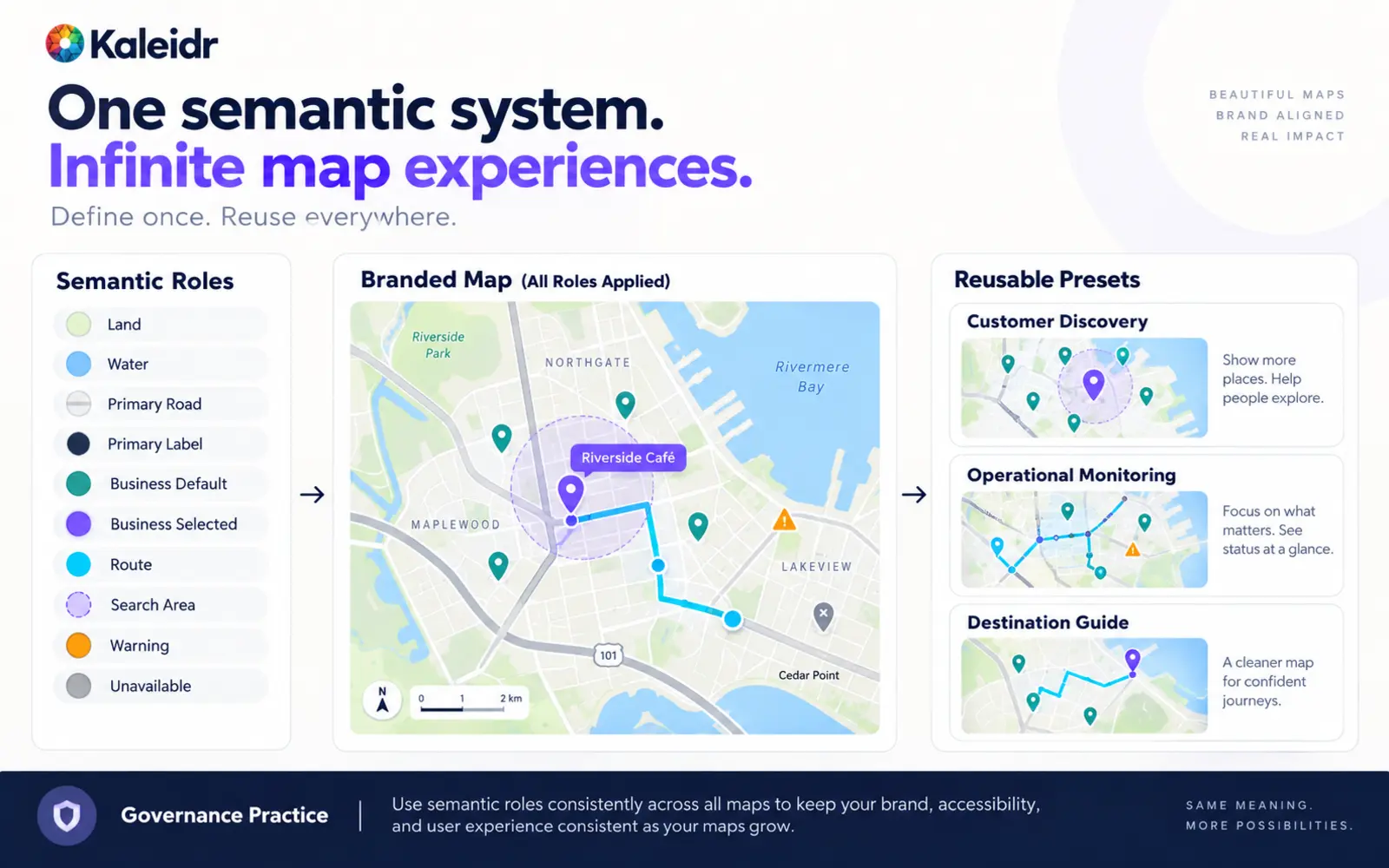
Reusable roles and presets reduce visual drift without forcing every map to look identical.
How Should Typography, Icons, and Interaction States Work?
Map type has to identify places, distinguish geographic hierarchy, stay readable over complex backgrounds, and still carry product identity. Country, city, neighborhood, road, business location, and selected-place labels should not share one weight and size. A corporate display font that works in marketing can fail on a map when letterforms are too wide, small text blurs, or international scripts are missing. Choose map typography for legibility first. Brand character can come from family, weight, spacing, selected labels, and the UI around the map.
Label density is a product decision. A customer-facing map may need business locations, major roads, and key neighborhoods. An operations map may need asset IDs, service regions, and incidents. More labels do not always make a better map. Icons need a smaller controlled vocabulary: which categories get unique marks, how selected state changes, how small icons remain legible, and how unknown categories fall back. Avoid a unique icon for every backend category. Fifty source categories can collapse into a handful of customer-facing treatments.
Interactive maps need reusable states: default, hover, selected, disabled, unavailable, and warning. Selection is the state users must read immediately. Stronger outline, size, label, connected card highlight, camera framing, and a detail panel can all carry it. Do not encode availability, warnings, or selection in color alone. Pair color with status text or icon treatment. Map and list or card views should share one place identity so selecting a marker selects the card and selecting the card highlights the marker.
3D should follow the same hierarchy. Studio currently documents terrain, hillshade, real elevation, and extruded buildings as context. The selected property or live asset remains primary. 3D Maps in Kaleidr Studio covers the visualization side. Live layers need additional roles such as current, recent, stale, offline, and warning so fleet, field-service, and event maps share one operational language. Confirm the supported integration path for a specific live-data source; the public Studio page describes live layers and moving assets, not a connector for any one feed.
How Should Teams Test, Publish, and Measure Branded Maps?
A style can look excellent at one zoom and fail at another. Test regional, city, neighborhood, street, and building scales. At broad zoom, simplify detail and reduce labels. At close zoom, reveal local roads and strengthen selected detail. The same style can succeed in one city and fail in a dense center, a sparse suburb, a coastal area, or a multilingual label field. Keep semantic roles consistent across markets. Allow density and camera to follow local context.
Mobile needs its own density: fewer visible categories, a larger selected marker, shorter labels, bottom-sheet details, and simpler controls. A desktop map does not simply shrink. Empty, loading, and error states are part of the system. A blank map with no explanation looks broken. Zero valid results is not the same as a failed data load, and markers should not pop in as if the empty view were the real catalog.
Accessibility belongs in the same checklist: contrast, selected-state redundancy, icon labels, text alternatives, non-color status cues, and reduced-motion behavior in the host experience. A visual map should not become the only way to retrieve the decision. Surrounding controls should remain usable from the keyboard where the host application supports it.
A map can look correct in Studio and change when embedded. Test container size, mobile layout, text scale, selected state, host background, page controls, and performance on the published surface. Map Publishing Guide covers the production handoff. Standalone maps, website embeds, and product integrations should inherit the same identity. Version the system so teams can see which maps still use an old selected state or icon family.
Kaleidr Analytics currently documents map loads, sessions, interactions, place engagement, and spatial patterns (Kaleidr, 2026). Suggested event names in this article are editorial recommendations, not documented automatic Kaleidr Analytics event names. Look for repeated zooming before selection, heavy filter churn, map and list mismatch, and low action rates after a place is selected. Spatial Analytics vs. Web Analytics covers why pageviews alone cannot answer those questions. Test the business outcome of a redesign, not only the screenshot.
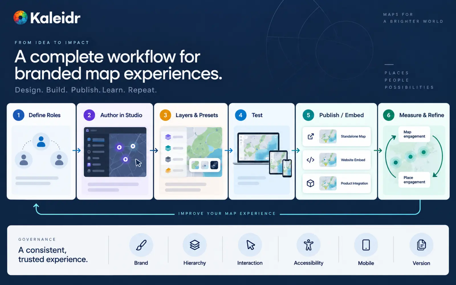
Treat map design as a repeatable product workflow: define, author, reuse, test, publish, and measure.
How Should a Team Roll Out a Studio Map Design System?
Start with one job and one surface, such as a public store locator or a property-search map. Define the semantic roles, author the first map in Studio, capture layers and presets, and test zooms, geographies, and devices before publishing. Expand to a second job only when the selected state, reference hierarchy, and mobile density hold. Retail networks, hospitality groups, and property platforms can then reuse the same marker, selected, route, and service-area treatments while the data changes.
Review every new map against brand, hierarchy, interaction, accessibility, mobile, and version. Confirm typography and accents, that product data outranks reference geography, that marker and card state stay synchronized, that meaning is not color-only, and that empty and error states were tested on the published surface. Conversational map layers and host application logic remain separate problems. Studio authors and publishes the spatial identity. The host still owns filters, account state, and transactions.
Explore Kaleidr Studio to create branded basemaps, reusable layers, presets, and interactive map experiences. Explore Kaleidr Analytics to measure place engagement after a design change. Confirm the current public pages before treating any example in this article as a shipping contract.
FAQs
What is a branded interactive map?
A branded interactive map uses a company's visual identity and product hierarchy across the basemap, labels, icons, overlays, selected states, and surrounding interaction rather than looking like a generic third-party map.
What is a map design system?
A map design system is a reusable set of rules for colors, typography, labels, icons, layers, routes, selected states, alerts, and other map behaviors across many maps.
How is a map design system different from a custom basemap?
A custom basemap styles reference geography such as land, water, roads, labels, and buildings. A map design system also governs product overlays, selection, routes, alerts, interaction states, and reuse across many map experiences.
Does Kaleidr Studio support reusable map styles?
Kaleidr Studio's current public page describes reusable layers, overlays, and style presets that can be saved and reapplied across maps.
Can Kaleidr Studio create branded basemaps?
Yes. The current Studio page documents custom map tiles with control over colors, typography, labels, and icons.
Does Kaleidr Studio support 3D maps?
Yes. The current Studio page documents 3D terrain, real elevation, hillshade, and extruded buildings.
Can Kaleidr Studio use live data layers?
The current Studio page describes live data layers and moving assets whose visual state updates as the underlying feed changes. Confirm the supported integration path for a specific live-data source.
Should every map use the exact same colors and layers?
No. The semantic roles should remain consistent, but each map can adapt density, camera, layers, and context to the user task.
Should map design tokens be stored in Kaleidr Studio?
Design tokens in this article are a governance practice. Kaleidr's public Studio page does not currently document a dedicated design-token import or management API.
How should a team test a branded map?
Test several zoom levels, geographies, screen sizes, light and dark contexts, selected states, empty states, accessibility conditions, and the actual published or embedded surface.
Can a branded map still use an existing application workflow?
Yes. Studio can handle spatial design and publishing while the host application remains responsible for business data, permissions, transactions, and other application logic.
How should teams measure whether a map redesign worked?
Measure customer outcomes such as place selection, task completion, directions, booking, inquiry, or another business action, along with diagnostic behaviors such as requery and filter churn.
References
- Kaleidr. AI Map Maker for Branded Interactive Maps. Accessed 16 September 2026. https://kaleidr.com/studio
- Kaleidr. Map Website Templates. Accessed 16 September 2026. https://template.kaleidr.com/
- MapLibre. MapLibre Style Specification. Accessed 16 September 2026. https://maplibre.org/maplibre-style-spec/
- Kaleidr. How to Build a Custom Branded Basemap. Accessed 16 September 2026. https://kaleidr.com/blog/how-to-build-a-custom-branded-basemap
- Kaleidr. 3D Maps in Kaleidr Studio. Accessed 16 September 2026. https://kaleidr.com/blog/3d-maps-kaleidr-studio
- Kaleidr. Map Publishing Guide. Accessed 16 September 2026. https://kaleidr.com/blog/map-publishing-guide
- Kaleidr. Map Engagement and Location Analytics. Accessed 16 September 2026. https://kaleidr.com/analytics
- Kaleidr. AI Interactive Map Builder: Prompt to Publish. Accessed 16 September 2026. https://kaleidr.com/blog/ai-interactive-map-builder
@misc{kaleidr_studio_design_system_2026,
  title  = {AI Map Maker for Branded Interactive Maps},
  author = {{Kaleidr}},
  year   = {2026},
  note   = {Accessed 16 September 2026},
  url    = {https://kaleidr.com/studio}
}

@misc{kaleidr_template_store_2026,
  title  = {Map Website Templates},
  author = {{Kaleidr}},
  year   = {2026},
  note   = {Accessed 16 September 2026},
  url    = {https://template.kaleidr.com/}
}

@misc{maplibre_style_spec_2026,
  title  = {MapLibre Style Specification},
  author = {{MapLibre}},
  year   = {2026},
  note   = {Page title currently reads Introduction - MapLibre Style Spec; access year used for the parenthetical; accessed 16 September 2026},
  url    = {https://maplibre.org/maplibre-style-spec/}
}

@misc{kaleidr_branded_basemap_2026,
  title  = {How to Build a Custom Branded Basemap},
  author = {{Kaleidr}},
  year   = {2026},
  note   = {Accessed 16 September 2026},
  url    = {https://kaleidr.com/blog/how-to-build-a-custom-branded-basemap}
}

@misc{kaleidr_3d_maps_studio_2026,
  title  = {3D Maps in Kaleidr Studio},
  author = {{Kaleidr}},
  year   = {2026},
  note   = {Accessed 16 September 2026},
  url    = {https://kaleidr.com/blog/3d-maps-kaleidr-studio}
}

@misc{kaleidr_map_publishing_2026,
  title  = {Map Publishing Guide},
  author = {{Kaleidr}},
  year   = {2026},
  note   = {Accessed 16 September 2026},
  url    = {https://kaleidr.com/blog/map-publishing-guide}
}

@misc{kaleidr_analytics_studio_2026,
  title  = {Map Engagement and Location Analytics},
  author = {{Kaleidr}},
  year   = {2026},
  note   = {Accessed 16 September 2026},
  url    = {https://kaleidr.com/analytics}
}

@misc{kaleidr_ai_map_builder_2026,
  title  = {AI Interactive Map Builder: Prompt to Publish},
  author = {{Kaleidr}},
  year   = {2026},
  note   = {Accessed 16 September 2026},
  url    = {https://kaleidr.com/blog/ai-interactive-map-builder}
}