
Location intelligence vs. spatial AI is a layering question for location products, not a replacement decision. Location intelligence is the business or operational insight created from geographic context: which place to recommend, which market is underserved, which route is better, or where coverage fails. Spatial AI is the AI layer that interprets place and map context, coordinates spatial tools, and helps people act on the result. A product can use both at once.
The sections below separate the two jobs, place GIS and GeoAI beside them without treating the labels as synonyms, then document Kaleidr from its current public pages. Related reading includes What Is Spatial AI?, GeoAI vs Spatial AI, What Is a Location Intelligence API?, and Location Intelligence Customer Experience Maps. Teams already choosing an implementation shape can skip to the combined architecture; teams still naming the category should start with the comparison table.
Comparison essentials
- Location intelligence is the decision value: Ranking, coverage, site choice, and market insight come from geographic context, with or without AI.
- Spatial AI is the intelligence layer: Natural-language intent, map state, and place context are interpreted, then tools are coordinated.
- Keep geometry deterministic: Distance, travel time, containment, and routing belong to spatial systems, not to a language model.
- GIS is technology, not the outcome: Geographic workflows can produce location intelligence; they are not the same term.
- Confirm the product contract: Kaleidr currently frames the platform as Spatial AI across AI, Studio, Analytics, and Enterprise, and describes Enterprise as location-intelligence infrastructure.
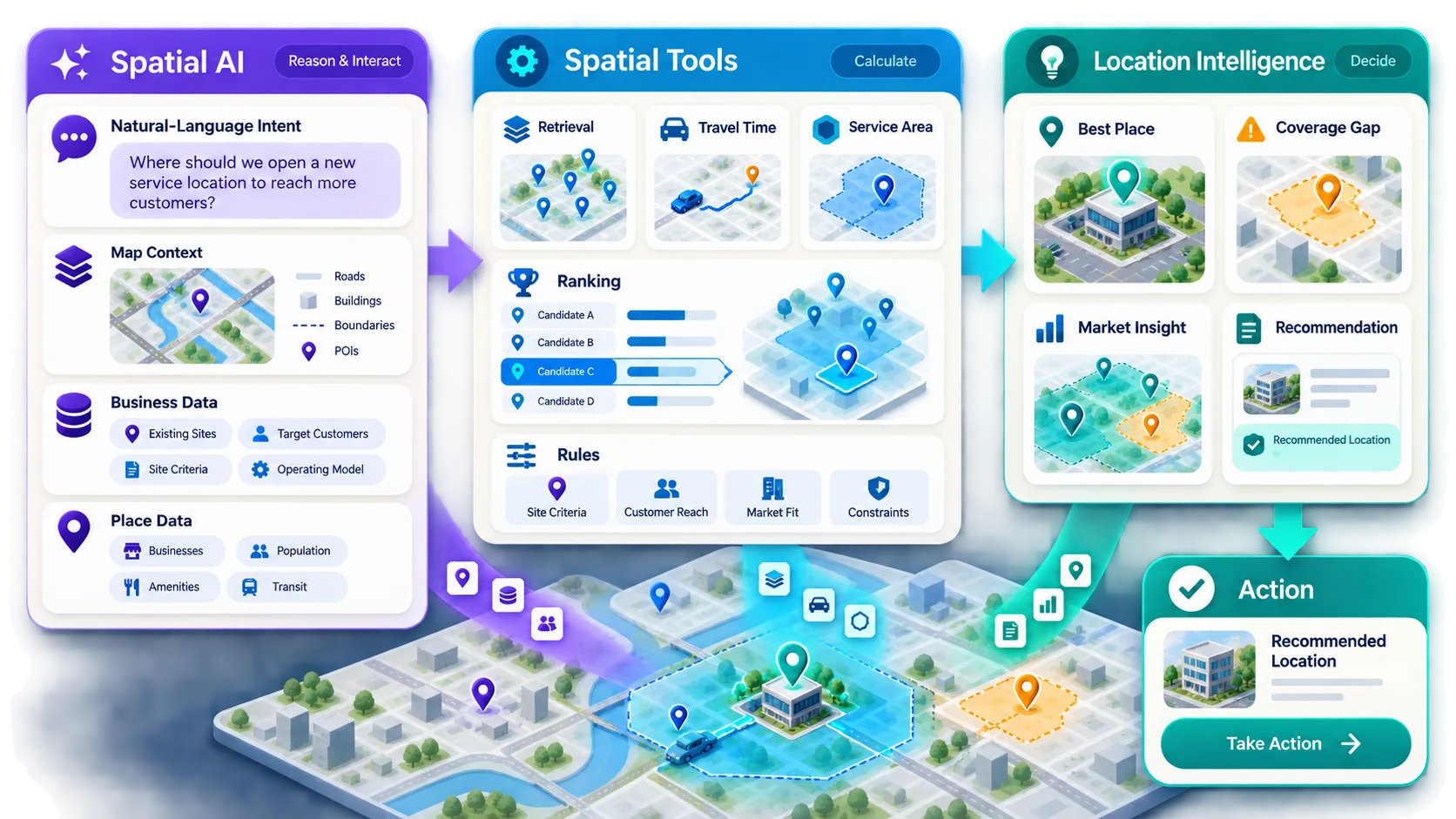
How Does Location Intelligence vs. Spatial AI Differ?
The useful split is the job each layer performs. Location intelligence is organized around a business or operational decision that geography can change. Spatial AI is organized around AI systems that work with maps, places, routes, regions, and other spatial context so a person can ask, explore, and act. Esri currently defines location intelligence as insight gained from visualizing and analyzing geospatial data, helping organizations understand where and why things happen and decide what to do next (What Is Location Intelligence?). CARTO describes location intelligence as deriving insights from location data to answer spatial questions, and emphasizes that the work goes beyond plotting records on a map (What Is Location Intelligence?). Neither definition requires a language model.
Spatial AI is broader than a dashboard label. Kaleidr currently uses Spatial AI as its primary platform framing and describes a stack that covers customer journeys, map creation, analytics, and enterprise integration (Build Your Own Spatial AI with Kaleidr). The Kaleidr AI product page describes a conversational map experience in which users can ask questions, discover places, plan, and navigate, while businesses ground answers on listings, venues, store locations, destination catalogs, brand voice, and policies (AI Map Chat for Customer Discovery). The documented jobs are a product definition of Spatial AI: AI that works with structured place and map context rather than treating location as ordinary text.
| Question | Location intelligence | Spatial AI |
|---|---|---|
| Primary purpose | Improve a location-dependent decision | Interpret, reason over, or interact with spatial context using AI |
| Typical user | Business, operations, product, analyst | Customer, operator, developer, product team |
| Typical input | Business data plus geographic data | Map state, place data, business context, and language or other AI inputs |
| Typical output | Insight, ranking, market decision, coverage choice | Answer, recommendation, map action, generated map, spatial workflow |
| Requires AI? | No | Yes, by definition |
| Requires a visible map? | No | Not always, but common in map products |
| Uses deterministic spatial calculations? | Often | Usually should, for distance, containment, routing, and geometry |
| Business orientation | Very strong | Depends on product design |
Why Are Location Intelligence and Spatial AI Easy to Confuse?
Both categories work with places, coordinates, maps, routes, regions, distance, and geographic context. Both can answer which store a customer should visit, which market has weak supply, which hotel fits a trip, or which locations should appear first. The overlap is real, so the labels get used as if they named one product. The difference is often the role the system plays rather than the dataset it stores.
Location intelligence usually follows a business question into geographic analysis and then into a decision. Spatial AI adds human intent, spatial context, tool coordination, and a grounded answer or map action. A modern product can run both paths on the same inventory. Calling every map “AI” or every geographic report “Spatial AI” hides that split and makes buying, staffing, and measurement harder.
What Is Location Intelligence?
Location intelligence is insight used to change a decision that depends on where things are. Site selection, trade-area comparison, service-area coverage, commute-constrained search, demand-versus-supply gaps, and provider matching are all location-intelligence jobs when geography changes the answer. Esri currently ties the category to visualization and analysis of geospatial data, then to planning the next action. CARTO currently contrasts the work with simply displaying results on a map and treats location analysis as part of a business or societal problem.
A map is a useful interface for that work. A map is not the definition. A ranking service can return a place identifier, a travel-time band, and an eligibility flag without rendering a viewport, and the result is still location intelligence. APIs, recommendation engines, and server-side workflows can therefore be location intelligence even when no dashboard is on screen. What Is a Location Intelligence API? covers that implementation shape.
Does Location Intelligence Require AI?
Location intelligence does not require AI. A customer address can be tested against a service area, filtered by inventory and hours, ranked by travel time, and returned as the nearest eligible store. Sales by store, population by region, and competitor locations can be joined into a market view without a language model. Those workflows remain location intelligence because the output is a geographic decision, not because a model generated the prose around it.
Teams should not label every geographic calculation as AI. Buffers, intersections, point-in-polygon tests, network routes, and zonal statistics stay deterministic until a learned model contributes classification, extraction, prediction, or ranking. AI can accelerate location intelligence by interpreting a request or summarizing a result. AI is not what makes the decision geographic.
What Is Spatial AI?
Spatial AI describes AI systems that work with spatial context: where something is, what is nearby, how places relate, what is visible on a map, which region is selected, how a route changes a choice, and what a user means by “near,” “between,” or “on the way.” What Is Spatial AI? is the definition pillar for that field. In a map product, Spatial AI often appears as conversational search, map-aware recommendations, prompt-driven map creation, or AI-assisted exploration.
Kaleidr AI currently documents Ask, Explore, Plan, and Navigate as customer-facing jobs, and it tells businesses to connect their own places and ground answers on inventory, brand voice, and policies rather than generic web search alone. Spatial AI is also broader than a chat window. Prompt-driven map creation, intelligent ranking instructions, map-aware actions, contextual route requests, and map-state reasoning can all sit in the same category. A panel that never receives map state, place identifiers, coordinates, a selected region, or route context is still text-only chat, even when it is drawn next to a map.
Should Spatial AI Replace Spatial Computation?
A language model can interpret “find a hotel close to the conference but convenient for the airport.” The model should not invent the geometry. A production path interprets the request, retrieves candidate places, runs deterministic spatial calculation, applies eligibility and ranking, then uses AI to explain the result and propose a map action. Distance, routing, point-in-polygon, intersection, containment, travel time, and coordinate transforms belong to spatial systems. AI is useful for interpreting constraints, choosing which tools to call, explaining tradeoffs, and coordinating map actions.
Place Ranking API covers presentation bias on the retrieval side: the first result can win clicks through layout rather than preference, so rank should be recorded as context rather than treated as proof of quality. The same boundary applies here. Spatial AI that estimates travel time from prose, invents availability, or ignores host eligibility is not a stronger location-intelligence system. Those answers are ungrounded.
Where Does GIS Fit Among These Terms?
A GIS is a system for working with geographic information, analysis, layers, spatial operations, and map-based workflows. Location intelligence can be produced with GIS. Spatial AI can call GIS or geospatial services. The terms are still not interchangeable. Esri currently says GIS software powers location intelligence by letting users manage, visualize, and analyze geospatial data (What Is Location Intelligence?). CARTO currently describes GIS as the systems and infrastructure used to collect, manage, and analyze spatial data, and location intelligence as turning that data into actionable insight with more emphasis on accessibility and business integration (What Is Location Intelligence?).
A clean working vocabulary is therefore: GIS for geographic technology and workflows; GeoAI for AI applied to geospatial data and analysis; Spatial AI for the broader intelligence layer that can work with maps, places, routes, and scenes; AI mapping for AI-assisted map creation and interaction; and location intelligence for the business or operational decision that geography supports. GeoAI vs Spatial AI is the technical comparison for the GeoAI split. AI Mapping is the product-category taxonomy.
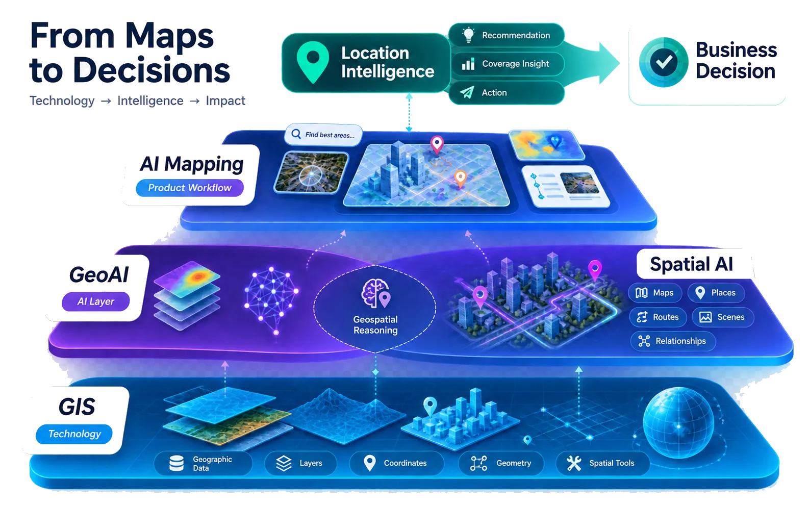
How Do Spatial AI, GeoAI, and Location Intelligence Differ?
GeoAI and geospatial AI usually name AI applied to geographic data, GIS, imagery, remote sensing, or geospatial analysis. Spatial AI can include that work and can also cover map-aware interaction, 3D scenes, robotics, and other spatial environments. Location intelligence is the decision after ranking, routing, coverage analysis, or site selection. AI mapping is the product workflow for creating, searching, editing, or interacting with maps. One product can span all four. Treating the four phrases as exact synonyms is the mistake.
The most useful label follows the job. Imagery classification and GIS automation point toward GeoAI. Conversational place search and map actions point toward Spatial AI. Market coverage and site choice point toward location intelligence. Authoring a branded map with prompts points toward AI mapping. Choose the term that tells a buyer, analyst, or developer what the system actually does.
Why Does the Distinction Matter for B2B Buyers?
A team buying a location-intelligence solution may need ranking, site analysis, market coverage, service-area logic, route comparison, or regional analytics. A team buying a Spatial AI layer may need conversational place search, natural-language map interaction, contextual recommendations, AI-assisted map creation, or interpretation of spatial intent. Those buying motions can share data and still differ in implementation, staffing, and success metrics.
The same inventory can feed both. Hospitality can use location intelligence to see which partner neighborhoods draw attention, then use Spatial AI so a guest can ask for a quiet restaurant near the hotel that fits a client dinner. Retail can rank stores by coverage and travel time, then let a shopper ask which store near the office has an item after closing time. Booking and marketplace products can keep availability and price in the host system, compute travel relationships in spatial services, and let AI explain the tradeoff. Location Intelligence Customer Experience Maps frames that customer job as discover, compare, and act.
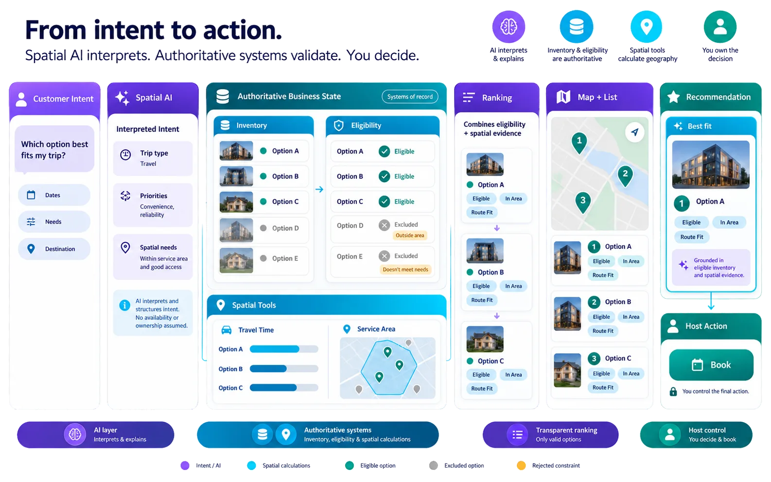
How Should a Location Product Combine Both Layers?
The strongest architecture gives each system a job. Business systems remain authoritative for inventory, hours, price, policy, and whether a booking or request actually occurred. Spatial systems remain authoritative for geometry, travel time, service area, and containment. Spatial AI interprets the request, selects tools, explains the result, and proposes map actions. Location intelligence is the decision those layers produce: a best place, a coverage gap, a market insight, or a ranked option list.
Customer intent should reach Spatial AI with map and place context, then flow through eligibility, travel time, service area, and ranking before a synchronized map and list present only valid options. The host still owns Book, Visit, Request, or Navigate. Copying every fact into the model recreates inconsistency at larger cost and makes privacy harder. Keep the recommendation grounded in identifiers the operational system already understands.
Where Does Kaleidr Fit Today?
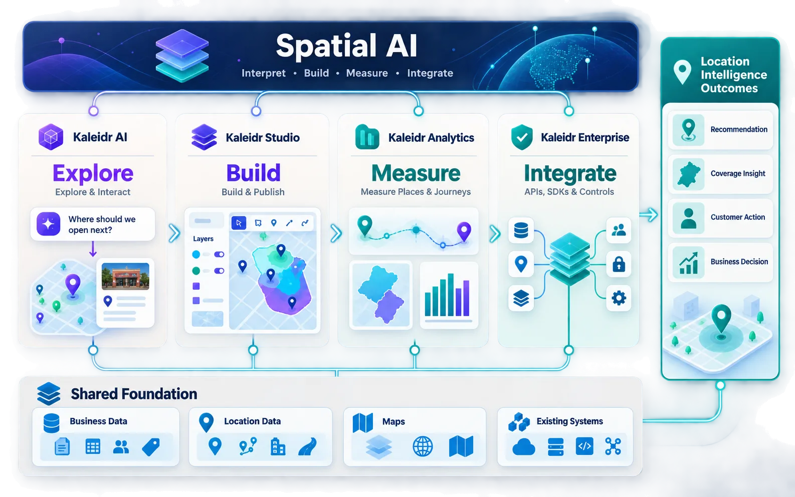
Kaleidr’s current homepage leads with “Build Your Own Spatial AI with Kaleidr” and presents four coordinated product layers: Kaleidr AI for conversational Spatial AI powered by business data; Kaleidr Studio for building and publishing branded AI maps; Kaleidr Analytics for understanding what customers search, explore, and act on across places and journeys; and Kaleidr Enterprise for APIs, SDKs, and enterprise controls that integrate Spatial AI into products (Build Your Own Spatial AI with Kaleidr). The same page describes connecting business data and location information, establishing a location-based business knowledge foundation, deploying Spatial AI into websites and apps, and learning from customer interaction.
Kaleidr Enterprise currently describes itself as “Spatial Intelligence Built for Your Stack” and references location-intelligence infrastructure, inference APIs, ranking systems, and analytics for location-aware product stacks (Location Intelligence APIs and Map SDK). Studio currently lists prompt-first map creation, custom map tiles, layers, real-time data, 3D visualization, branding, and publishing (AI Map Maker for Branded Interactive Maps). Analytics currently documents dashboards, audience, engagement, and insights for map and place measurement (Map Engagement and Location Analytics). Spatial AI is the platform framing. Location intelligence is the decision infrastructure and measurement outcome inside that framing. Confirm current availability on Pricing & Plans before depending on a specific production workflow.
Which Term Should Product Pages, RFPs, and Developers Use?
Use Spatial AI when the page emphasizes AI interaction, conversational maps, place-aware recommendations, map creation, or AI-assisted spatial workflows. Use location intelligence when the page emphasizes business decisions, market analysis, ranking, coverage, spatial analytics, or enterprise infrastructure. Use both when AI makes location intelligence directly actionable for a customer or operator. A working line is Spatial AI for customer-facing maps, powered by location intelligence from business data.
A buyer should describe the capability rather than rely on one umbrella term. Ask for natural-language place search, business-data grounding, map-aware AI, location ranking, travel-time analysis, service-area logic, place analytics, SDK integration, custom map authoring, and enterprise access controls. Developers should keep the technical boundary explicit: the Spatial AI layer parses intent and proposes map actions; location-intelligence services return place context, ranking, routes, or analysis. Calling every endpoint an AI API hides which system is allowed to invent an answer.
What Mistakes Should Teams Avoid?
The recurring failure is treating a nearby term as a substitute. Replacing GIS or web analytics with a language model deletes authoritative geometry and acquisition context. Plotting records on a map is visualization, not location intelligence, until a spatial question is answered. A chat panel without map state is not Spatial AI. Measuring Spatial AI only by message volume rewards long failure. Spatial Analytics vs. Web Analytics covers the measurement half of that last mistake.
| Mistake | Result | Better approach |
|---|---|---|
| Treat the labels as synonyms | Buying and staffing target the wrong layer | Name the job: decision, AI interaction, GIS, or map workflow |
| Let a language model invent distance or eligibility | Ungrounded recommendations | Keep geometry and business facts authoritative |
| Equate a map with location intelligence | Visualization mistaken for insight | Start from a geographic decision |
| Equate chat with Spatial AI | Text-only answers beside a map | Pass map state, place IDs, and route context |
| Optimize AI for message volume | Long failure looks successful | Measure valid place selection and task completion |
| Copy every record into the model | Privacy and consistency cost rise | Join through stable IDs and minimum precision |
How Should Teams Handle Location Privacy?
The W3C Geolocation specification currently states that retrieving a device’s geographic location “also discloses the location of the user of the device, thereby potentially compromising the user’s privacy,” and it tells developers that privacy laws in their jurisdictions can govern usage and access (Geolocation). Home address, work location, route, travel dates, and precise current location can all be sensitive even when a place catalog is public. Prefer place identifiers, region identifiers, travel-time bands, and service-area identifiers when those answer the business question.
A place ID may be public while a user’s precise origin is sensitive. Do not treat them as equivalent. Authorization should run before private business locations reach the AI layer. Private Location Data for AI Map Workflows covers minimization and access control for those records. The correct policy depends on the deployment and legal context; this article describes the measurement and architecture design, not a determination for a specific reader.
How Can Teams Build Spatial AI Around Location Intelligence?
Start with one location-dependent customer or operational decision. Define authoritative data, hard eligibility, required spatial calculations, and the business outcome. Add Spatial AI when natural-language intent or map-aware interaction materially improves that workflow. Explore Kaleidr AI for conversational map experiences grounded in business places. Explore Kaleidr Enterprise for APIs, SDKs, ranking systems, analytics, and deployment controls described on the current public page.
FAQs
Is location intelligence the same as Spatial AI?
No. Location intelligence is the insight or decision created from geographic context. Spatial AI is AI that interprets or acts on spatial context. Spatial AI can help produce location intelligence.
Does location intelligence require artificial intelligence?
No. Location intelligence can be produced with GIS, spatial analytics, routing, business rules, or deterministic calculations without AI.
Does Spatial AI require a map?
Not necessarily. Spatial AI can work with coordinates, routes, 3D environments, trajectories, and other spatial representations. In customer-facing location products, an interactive map is a common interface.
What is an example of location intelligence?
Ranking eligible stores by travel time and inventory, identifying an underserved market, or finding the best site for a new location are all examples.
What is an example of Spatial AI?
A map-aware assistant interpreting “find a hotel near the conference but convenient for the airport” and coordinating place retrieval, routing, ranking, and a map action is an example.
Is location intelligence the same as GIS?
No. GIS is technology and a set of geographic workflows. Location intelligence is the business or operational insight derived from geographic context. GIS is one way to produce it.
Is Spatial AI the same as GeoAI?
Not exactly. GeoAI usually refers to AI applied to geographic data, GIS, imagery, and geospatial analysis. Spatial AI is broader and can include map-aware interaction, robotics, 3D environments, and other spatial contexts.
Is AI mapping the same as Spatial AI?
AI mapping is a product category focused on AI-assisted map creation, search, editing, analysis, and interaction. Spatial AI is a broader intelligence category that can power AI mapping.
Where does Kaleidr fit?
Kaleidr uses Spatial AI as its broader platform framing. Kaleidr AI provides customer-facing conversational spatial experiences, Studio provides AI-assisted map authoring, Analytics measures place-centered behavior, and Enterprise provides location-intelligence infrastructure, SDKs, APIs, ranking systems, analytics, and controls as those pages currently document.
Can Kaleidr replace our current map provider?
Replacement of the current map provider is not Kaleidr's core positioning. Kaleidr can attach AI to existing compatible maps and add spatial-intelligence layers while the host keeps its current renderer, business systems, and authoritative data.
What should a B2B team implement first?
Start with one location-dependent customer or operational decision. Define authoritative data, hard eligibility, required spatial calculations, and the business outcome. Add Spatial AI when natural-language intent or map-aware interaction materially improves that workflow.
References
- Kaleidr. Build Your Own Spatial AI with Kaleidr. Accessed 2 September 2026. https://kaleidr.com/
- Kaleidr. AI Map Chat for Customer Discovery. Accessed 2 September 2026. https://kaleidr.com/ai
- Kaleidr. Location Intelligence APIs and Map SDK. Accessed 2 September 2026. https://kaleidr.com/enterprise
- Kaleidr. AI Map Maker for Branded Interactive Maps. Accessed 2 September 2026. https://kaleidr.com/studio
- Kaleidr. Map Engagement and Location Analytics. Accessed 2 September 2026. https://kaleidr.com/analytics
- Esri. What Is Location Intelligence?. Accessed 2 September 2026. https://www.esri.com/en-us/location-intelligence/overview
- CARTO. What Is Location Intelligence?. Accessed 2 September 2026. https://carto.com/location-intelligence/
- W3C. Geolocation. W3C Candidate Recommendation Snapshot, 26 March 2026. Accessed 2 September 2026. https://www.w3.org/TR/geolocation/
@misc{kaleidr_spatial_ai_home_2026_09_02,
  title  = {Build Your Own Spatial AI with Kaleidr},
  author = {{Kaleidr}},
  note   = {Accessed 2 September 2026},
  url    = {https://kaleidr.com/}
}

@misc{kaleidr_ai_2026_09_02,
  title  = {AI Map Chat for Customer Discovery},
  author = {{Kaleidr}},
  note   = {Accessed 2 September 2026},
  url    = {https://kaleidr.com/ai}
}

@misc{kaleidr_enterprise_2026_09_02,
  title  = {Location Intelligence APIs and Map SDK},
  author = {{Kaleidr}},
  note   = {Accessed 2 September 2026},
  url    = {https://kaleidr.com/enterprise}
}

@misc{kaleidr_studio_2026_09_02,
  title  = {AI Map Maker for Branded Interactive Maps},
  author = {{Kaleidr}},
  note   = {Accessed 2 September 2026},
  url    = {https://kaleidr.com/studio}
}

@misc{kaleidr_analytics_2026_09_02,
  title  = {Map Engagement and Location Analytics},
  author = {{Kaleidr}},
  note   = {Accessed 2 September 2026},
  url    = {https://kaleidr.com/analytics}
}

@misc{esri_location_intelligence_2026_09_02,
  title  = {What Is Location Intelligence?},
  author = {{Esri}},
  note   = {Accessed 2 September 2026},
  url    = {https://www.esri.com/en-us/location-intelligence/overview}
}

@misc{carto_location_intelligence_2026_09_02,
  title  = {What Is Location Intelligence?},
  author = {{CARTO}},
  note   = {Accessed 2 September 2026},
  url    = {https://carto.com/location-intelligence/}
}

@misc{w3c_geolocation_2026_09_02,
  title  = {Geolocation},
  author = {{W3C}},
  note   = {W3C Candidate Recommendation Snapshot, 26 March 2026. Accessed 2 September 2026},
  url    = {https://www.w3.org/TR/geolocation/}
}