
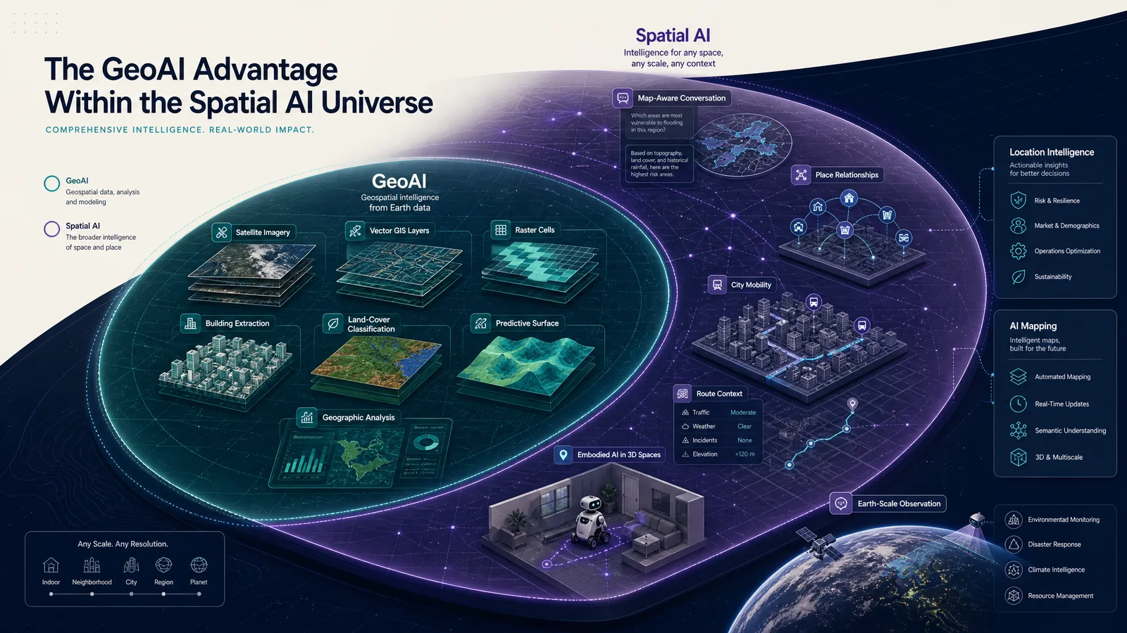
GeoAI vs spatial AI is mainly a question of scope. GeoAI and geospatial AI usually name the same practice: applying machine learning or related methods to geographic data, GIS, remote sensing, and spatial analysis. Spatial AI is broader. The label can include GeoAI, and it can also describe systems that interpret or act on position, distance, containment, movement, map state, or 3D scene structure across maps, cities, robotics, and Earth observation.
The sections below separate the labels, show how data and output usually decide the better term, and place Kaleidr in that vocabulary. Related reading includes What Is Spatial AI?, AI Mapping, Digital Mapping, and What Is a Location Intelligence API?. For a map-product architecture, see How to Build a Map-Aware AI Assistant.
Comparison essentials
- GeoAI ≈ geospatial AI: AI applied to geographic data, GIS, imagery, and geospatial analysis.
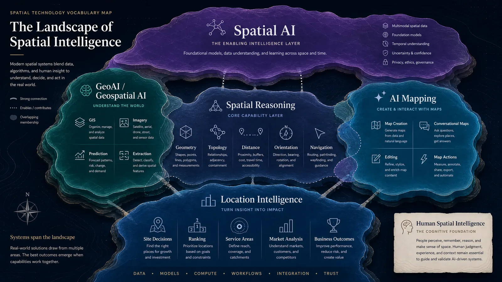
- Spatial AI is broader: Maps, GeoAI, robotics, 3D scenes, cities, and Earth-scale systems can all sit under the umbrella.
- Location intelligence is an outcome: The decision after ranking, routing, or site analysis—not a synonym for either field.
- AI mapping is a product category: Creation, conversation, editing, and map actions, which may use GeoAI as one component.
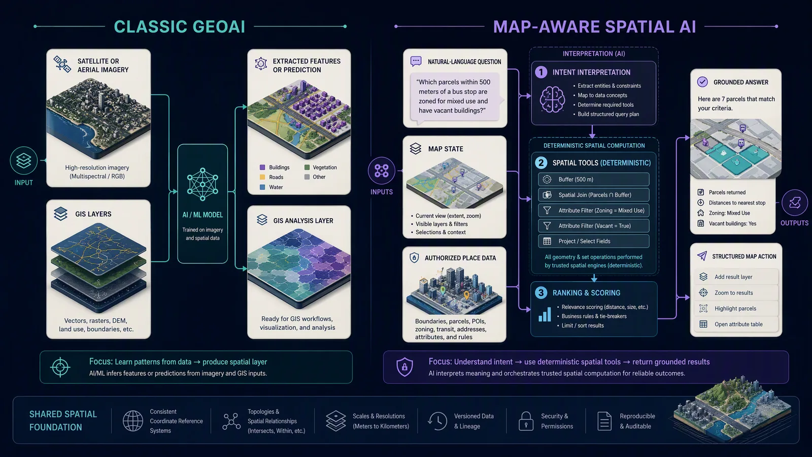
- Intent ≠ geometry: Language models interpret requests; spatial engines compute distance, containment, and routes.
How Do GeoAI vs Spatial AI Differ?
No single standards body publishes an official split between the two phrases, so vendor pages, research surveys, and product teams use them with overlapping but not identical scope. The useful distinction is practical. GeoAI is usually anchored in geographic data plus GIS or geospatial science plus AI methods. Spatial AI can operate on that same stack, or on map state, trajectories, robotic scenes, or other spatial representations that are not primarily GIS layers. A 2025 survey of language-model-powered spatial intelligence treats the research field across embodied agents, urban systems, and Earth science rather than as GIS alone (Feng et al., 2025). For that reason, treating the labels as exact synonyms hides the difference readers actually need: which spatial problem the system solves, and which data and calculations it requires.
| Term | Working definition | Typical data | Typical output |
|---|---|---|---|
| Geospatial AI | AI applied to geographic data and geospatial problems | GIS layers, imagery, vectors, rasters, point clouds | Classification, prediction, extraction, spatial analysis |
| GeoAI | Common abbreviation for geospatial artificial intelligence | Same as geospatial AI | Same as geospatial AI |
| Spatial AI | Broader AI that uses spatial context and relationships | Maps, coordinates, scenes, 3D environments, trajectories, place data | Reasoning support, navigation, recommendations, map actions, spatial decisions |
| Location intelligence | Decision-oriented use of location context | Business records plus geographic data | Site, market, routing, service, or operational decision |
| AI mapping | Product category where AI creates, analyzes, or interacts with maps | Map data plus AI context | Map generation, conversational search, editing, spatial workflows |
What Is Geospatial AI, and Is GeoAI the Same Term?
Geospatial artificial intelligence is AI applied to geographic information, spatial data, and geospatial science. Esri currently defines GeoAI as AI fused with geospatial data, science, and technology to accelerate understanding of business opportunities, environmental impacts, and operational risks (What Is GeoAI?). ArcGIS Pro documentation lists classification, clustering, prediction, forecasting, feature extraction, imagery analysis, and spatially explicit methods, and still assigns the analyst responsibility for problem framing and communication (GeoAI in ArcGIS Pro). In most product and research writing, GeoAI, geospatial AI, and geospatial artificial intelligence name that same cluster. Separate SEO pages for each synonym usually cannibalize one another unless the search intent is genuinely different.
A typical GeoAI pipeline prepares imagery or GIS features, trains or applies a model, and writes a prediction or extraction back to a geographic layer. Extracting building footprints from aerial imagery, classifying land cover, detecting change, forecasting wildfire risk, or automating a geoprocessing step are all recognizably GeoAI even when no conversational interface or consumer map is present. NASA Earthdata describes AI and machine learning as tools for finding patterns in large Earth-observation datasets and improving analysis of the planet (Earth Observation Data and Artificial Intelligence). Research systems such as OmniGeo explore multimodal models that take satellite imagery, geospatial metadata, and text as GeoAI inputs (Yuan et al., 2025). Geospatial analytics, by contrast, does not require AI: buffers, intersections, point-in-polygon tests, network routes, and zonal statistics remain deterministic GIS operations until a learned model contributes classification, extraction, prediction, or ranking.
What Does Spatial AI Include That GeoAI Does Not?
Spatial AI is the broader idea of artificial intelligence that can interpret, predict, or act on spatial relationships and environments. Position, distance, direction, orientation, containment, adjacency, visibility, movement, reachability, topology, place context, and 3D scene structure can all count as spatial context. A robot navigating a room, a map assistant that interprets “show the ones east of the river,” a model ranking city mobility options, and an Earth-observation classifier can all be described as spatial AI; only the last two are also classic GeoAI. Calling the robotics case GeoAI is usually misleading because the problem is not fundamentally geographic.
The same breadth explains why the terms are harder to separate than they were when GeoAI mostly meant GIS plus machine learning and spatial AI mostly appeared in robotics, computer vision, and SLAM. Multimodal systems now combine text, satellite imagery, street-level imagery, maps, coordinates, trajectories, vector geometry, point clouds, and structured place data. Spatial AI remains the wider umbrella in a conceptual model, not a formal standards taxonomy: GeoAI sits inside it alongside map-aware products, embodied spatial systems, 3D scene intelligence, and navigation. Human spatial intelligence is broader still—a cognitive capability—and should not be read automatically as a software category. In product language, spatial intelligence is the capability; spatial AI is the family of systems that implement it.
How Do Classic GeoAI and Map-Aware Workflows Differ?
A city that wants buildings at high wildfire risk can combine satellite or aerial imagery, terrain, vegetation, footprints, and fire history. A model may extract buildings, classify land cover, predict risk, or detect post-fire damage; GIS then joins those outputs to slope, road access, evacuation zones, and parcels. The wildfire workflow is classic GeoAI, and remains spatial AI only in the broadest sense. GeoAI is the more precise label because the work centers on geospatial data and analysis.
A request such as “family-friendly restaurants near the waterfront, within a 15-minute walk of my hotel, still open this evening” needs a different stack. The application must interpret entity type, preference, area, origin, travel constraint, and time, then retrieve places, hours, routes, ranking, map state, and structured map actions. The restaurant request is better described as spatial AI or map-aware AI than as traditional GeoAI, because the task is not primarily imagery analysis or GIS automation. How to Build a Map-Aware AI Assistant walks through shared map state and validated actions for that pattern.
Exact geometry still belongs to a spatial engine in both workflows. OGC Simple Feature Access, also published as ISO 19125, defines the common architecture for simple feature geometry and the spatial operations implementations expose for points, curves, surfaces, and collections (Simple Feature Access — Part 1). Research evaluating foundation models on vector geometries and topological relations finds that geospatial reasoning remains an active challenge, especially for precise representation and formal spatial relationships (Ji et al., 2025). Production systems should therefore let the language model interpret intent and choose an operation, while a geospatial engine or database calculates distance, route, intersection, and containment. Do not label deterministic geometry as AI merely because the result appears on an AI-enabled map.
How Should Teams Choose Among Nearby Terms?
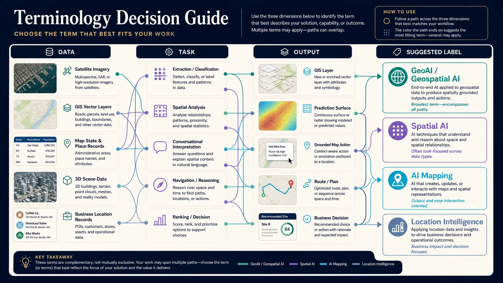
The most useful term usually follows the combination of data, task, output, and audience rather than a marketing preference. Imagery, vectors, rasters, and GIS layers point toward GeoAI or geospatial AI. Map state, places, user intent, routes, and business records point toward spatial AI, map-aware AI, or location-aware AI. Depth, objects, and robots point toward spatial AI or embodied spatial intelligence. Business decision context points toward location intelligence. Authoring or interacting with maps points toward AI mapping. Several paths can overlap; choose the label that tells a reader the most about the actual job.
Location intelligence is outcome-oriented: which market to enter, which store is best positioned, which property fits a commute, which territory is underserved, which warehouse should fulfill an order. GIS, GeoAI, routing, demographics, and spatial AI can all feed that decision. What Is a Location Intelligence API? covers the API shape. AI mapping is a product and workflow category—creating maps, searching them conversationally, generating layers, styling, ranking places, or automating geographic workflows—not a synonym for GeoAI. A GeoAI model may extract roads from imagery; an AI-mapping product lets a user view, edit, analyze, and discuss those roads. AI Mapping is the taxonomy for that product class. Digital Mapping covers the renderer and data stack underneath.
| Question | GeoAI / geospatial AI | Spatial AI |
|---|---|---|
| Is geography central? | Yes | Sometimes |
| Is GIS common? | Very common | Optional |
| Is remote sensing common? | Very common | Possible |
| Is robotics included? | Usually no | Yes |
| Is 3D scene understanding included? | Sometimes | Yes |
| Is conversational map search included? | Possible | Common product reading |
| Is map state relevant? | Sometimes | Often |
| Are exact spatial operations relevant? | Yes | Yes |
| Is a conversational interface required? | No | No, but increasingly common |
| Is the category standardized? | No single universal standard | No single universal standard |
Use GeoAI when the product primarily analyzes imagery, automates GIS, predicts geographic phenomena, extracts geospatial features, or serves GIS specialists. Use spatial AI when the product interprets map context, supports natural-language location questions, coordinates spatial tools, or spans maps and other spatial environments. Use location intelligence when the product ranks locations, evaluates markets, or combines business and geographic context for a decision. Use AI mapping when the product creates, edits, styles, or converses with maps. One platform can honestly use more than one term when the terms describe different layers.
Where Does Kaleidr Fit?
Kaleidr uses Spatial AI as its primary product framing because the system is centered on place and map context rather than only GIS machine-learning workflows. The current Spatial AI page describes the capability as AI applied to places and location data—what a place is, what is nearby, and why it may be relevant (Kaleidr Spatial AI). Explore supports natural-language place discovery; Studio supports prompt-first map creation; Chat attaches map-aware AI to an existing map; Analytics measures spatial engagement; Enterprise packages location-intelligence APIs, ranking, and spatial infrastructure (Kaleidr Enterprise). The resulting mix is closer to spatial AI plus location intelligence plus AI mapping than to a traditional remote-sensing GeoAI product.
Spatial AI does not replace the underlying stack. A production system may still need Mapbox, Google Maps, MapLibre, GIS databases, geocoding, routing, vector tiles, imagery, and business systems. Kaleidr’s current product supports attaching Chat to existing map implementations and grounding customer-facing answers on business locations and policies. Host systems should remain authoritative for data, permissions, business rules, map rendering, and exact geographic computation. The spatial-AI layer makes those systems easier to query and interact with; it does not become the source of truth for geometry or inventory.
Which Terminology Mistakes Should Teams Avoid?
Treating GeoAI and spatial AI as exact synonyms erases the broader uses of spatial AI. Treating GeoAI as only imagery AI ignores prediction, clustering, and GIS automation. Calling every spatial calculation AI confuses deterministic geometry with learned methods. Calling every map product GIS confuses a consumer interface with infrastructure. Labeling a text-only assistant as spatial AI when it never receives map state or coordinates inflates the category. Asking a language model to perform exact geometry ignores both OGC feature operations and current evaluation of topological reasoning. Building five near-duplicate pages for GeoAI, geospatial AI, geospatial artificial intelligence, spatial AI, and AI GIS usually splits one cluster instead of strengthening it.
A cleaner internal cluster is a definition page for spatial AI, this comparison, the AI-mapping taxonomy, a location-intelligence API guide, and implementation posts. The comparison page should answer terminology questions and send readers to the pillar that matches their use case, rather than restating every adjacent guide in full. Search and answer engines then resolve one vocabulary node instead of five competing near-duplicates.
Final Verdict
GeoAI and geospatial AI are best treated as the same category: artificial intelligence applied to geographic data, GIS, remote sensing, and geospatial analysis. Spatial AI is broader. The term includes geospatial problems and can also describe systems that use spatial relationships, map context, navigation, 3D environments, embodied scenes, and other forms of space. A compact relationship is: GeoAI is geospatial AI; GeoAI is often part of spatial AI; spatial AI is not limited to GeoAI.
For map and location products, the terminology becomes useful when it describes a real system boundary. The language model interprets intent. Trusted systems provide facts. Spatial engines calculate relationships. The application applies the result. Kaleidr uses Spatial AI because its current surfaces combine natural-language place discovery, map-aware interaction, map creation, ranking, and location intelligence while leaving the existing map renderer and business systems authoritative.
Explore Spatial AI With Kaleidr
See how natural-language place discovery and map-aware recommendations work inside an interactive map. Explore Kaleidr Spatial AI for the current Explore, Studio, Chat, and Enterprise surfaces.
FAQs
Is GeoAI the same as geospatial AI?
Yes, in most current usage. GeoAI is a common abbreviation for geospatial artificial intelligence: AI applied to geospatial data, GIS, remote sensing, and spatial-analysis workflows.
Is GeoAI the same as spatial AI?
Not exactly. GeoAI is focused on geographic and geospatial data. Spatial AI is a broader term that can include GeoAI as well as robotics, 3D scene understanding, navigation, conversational maps, and other spatially aware systems.
Is spatial AI broader than GeoAI?
Yes. That is the most useful practical distinction. Spatial AI can operate across geographic, physical, virtual, and embodied spatial environments, while GeoAI is centered on geographic data and problems.
What are examples of GeoAI?
Examples include extracting buildings from satellite imagery, classifying land cover, forecasting wildfire risk, detecting geographic change, automating GIS workflows, and predicting spatial patterns.
What are examples of spatial AI?
Examples include a robot navigating a room, an AI map assistant interpreting a selected area, a system ranking places by travel time and context, a 3D scene model, and Earth-scale geospatial reasoning.
Is location intelligence the same as GeoAI?
No. Location intelligence is usually the business or operational decision derived from location context. GeoAI is one technology that can contribute to location-intelligence workflows.
Is AI mapping the same as GeoAI?
No. AI mapping is a product and workflow category that includes map creation, conversational map search, AI-assisted editing, spatial analysis, and other AI-driven map interactions. GeoAI can be one component of an AI-mapping system.
Does GeoAI require GIS?
Not necessarily as a visible user interface, but GeoAI normally works with geospatial data, geographic reference systems, or geospatial methods. GIS technology is very common in GeoAI workflows.
Does spatial AI require a map?
No. Spatial AI can operate in robotics, 3D scenes, physical environments, navigation systems, and other contexts where spatial relationships matter.
Can a language model perform geospatial analysis by itself?
The model can interpret many geographic questions, but precise geometry and topological reasoning remain challenging. Production systems should use deterministic spatial engines for routing, distance, intersection, and containment.
Why does Kaleidr use the term Spatial AI?
Kaleidr’s current product extends beyond geospatial analysis into natural-language place discovery, map-aware recommendations, map creation, ranking, and customer-facing spatial experiences. Spatial AI is therefore a better umbrella than a narrower GIS-focused GeoAI label.
References
- Esri. GeoAI in ArcGIS Pro. ArcGIS Pro documentation. Accessed 21 August 2026. https://doc.esri.com/en/arcgis-pro/latest/help/analysis/ai/geoai.html
- Esri. What Is GeoAI? Accessed 21 August 2026. https://www.esri.com/en-us/capabilities/geoai/overview
- Feng, Jie, Jinwei Zeng, Qingyue Long, et al. A Survey of Large Language Model-Powered Spatial Intelligence Across Scales: Advances in Embodied Agents, Smart Cities, and Earth Science. arXiv:2504.09848, 2025. https://arxiv.org/abs/2504.09848
- Ji, Yuhan, Song Gao, Ying Nie, Ivan Majić, and Krzysztof Janowicz. Foundation Models for Geospatial Reasoning: Assessing Capabilities of Large Language Models in Understanding Geometries and Topological Spatial Relations. arXiv:2505.17136, 2025. https://arxiv.org/abs/2505.17136
- Kaleidr. AI Maps You Can Talk To — Spatial AI. Accessed 21 August 2026. https://kaleidr.com/ai
- Kaleidr. Kaleidr Enterprise. Accessed 21 August 2026. https://kaleidr.com/enterprise
- NASA Earthdata. Earth Observation Data and Artificial Intelligence. Accessed 21 August 2026. https://www.earthdata.nasa.gov/learn/earth-observation-data-basics/artificial-intelligence
- Open Geospatial Consortium. Simple Feature Access — Part 1: Common Architecture. OGC 06-103r4 / ISO 19125. Accessed 21 August 2026. https://www.ogc.org/standards/sfa/
- Yuan, Long, Fengran Mo, Kaiyu Huang, et al. OmniGeo: Towards a Multimodal Large Language Models for Geospatial Artificial Intelligence. arXiv:2503.16326, 2025. https://arxiv.org/abs/2503.16326
@misc{esri_geoai_2026,
  title  = {What Is GeoAI?},
  author = {{Esri}},
  note   = {Accessed 21 August 2026},
  url    = {https://www.esri.com/en-us/capabilities/geoai/overview}
}

@misc{esri_arcgis_pro_geoai_2026,
  title  = {GeoAI in ArcGIS Pro},
  author = {{Esri}},
  note   = {ArcGIS Pro documentation; accessed 21 August 2026},
  url    = {https://doc.esri.com/en/arcgis-pro/latest/help/analysis/ai/geoai.html}
}

@article{feng2025spatialintelligence,
  title   = {A Survey of Large Language Model-Powered Spatial Intelligence Across Scales: Advances in Embodied Agents, Smart Cities, and Earth Science},
  author  = {Feng, Jie and Zeng, Jinwei and Long, Qingyue and others},
  year    = {2025},
  journal = {arXiv preprint arXiv:2504.09848},
  url     = {https://arxiv.org/abs/2504.09848}
}

@article{yuan2025omnigeo,
  title   = {OmniGeo: Towards a Multimodal Large Language Models for Geospatial Artificial Intelligence},
  author  = {Yuan, Long and Mo, Fengran and Huang, Kaiyu and others},
  year    = {2025},
  journal = {arXiv preprint arXiv:2503.16326},
  url     = {https://arxiv.org/abs/2503.16326}
}

@article{ji2025geospatialreasoning,
  title   = {Foundation Models for Geospatial Reasoning: Assessing Capabilities of Large Language Models in Understanding Geometries and Topological Spatial Relations},
  author  = {Ji, Yuhan and Gao, Song and Nie, Ying and Maji{\'c}, Ivan and Janowicz, Krzysztof},
  year    = {2025},
  journal = {arXiv preprint arXiv:2505.17136},
  url     = {https://arxiv.org/abs/2505.17136}
}

@misc{nasa_earthdata_ai_2026,
  title  = {Earth Observation Data and Artificial Intelligence},
  author = {{NASA Earthdata}},
  note   = {Accessed 21 August 2026},
  url    = {https://www.earthdata.nasa.gov/learn/earth-observation-data-basics/artificial-intelligence}
}

@misc{ogc_sfa_part1_2026,
  title  = {Simple Feature Access -- Part 1: Common Architecture},
  author = {{Open Geospatial Consortium}},
  note   = {OGC 06-103r4 / ISO 19125; accessed 21 August 2026},
  url    = {https://www.ogc.org/standards/sfa/}
}

@misc{kaleidr_spatial_ai_2026_08_21,
  title  = {AI Maps You Can Talk To -- Spatial AI},
  author = {{Kaleidr}},
  note   = {Accessed 21 August 2026},
  url    = {https://kaleidr.com/ai}
}

@misc{kaleidr_enterprise_2026_08_21,
  title  = {Kaleidr Enterprise},
  author = {{Kaleidr}},
  note   = {Accessed 21 August 2026},
  url    = {https://kaleidr.com/enterprise}
}