
Live fleet tracking combines a vehicle or asset's current position with status, job context, service geography, and data freshness. Spatial AI lets an operator ask which eligible vehicles are near a job, which assets are stale, or which field team is inside a service area. The telematics or dispatch system remains authoritative for GPS, assignments, and routes. Kaleidr interprets the question and explains grounded results on the map.
The sections below separate telematics, dispatch, the map, and Spatial AI, then cover freshness, audience-specific views, and a narrow pilot. Related reading includes Real-Time Maps in Kaleidr Studio, Location Intelligence vs. Spatial AI, Grounded Spatial AI for Business Data, and An Enterprise Spatial AI Pilot. A real-time map article explains how a branded canvas stays stable while live data changes. Live fleet tracking asks a different question: which assets are eligible for the next operational action.
Live fleet tracking essentials
- Identity stays stable: One asset ID survives every position update, rename, and shift change.
- Freshness is part of the position: A marker without an update time can look current after the feed has stopped.
- Silence is not stillness: A missing message can mean a stall, a tunnel, or a disconnected device.
- Eligibility comes before nearest: Status, territory, and job rules filter the set before distance ranks it.
- Audiences do not share one payload: Internal operations and customer tracking expose different fields.
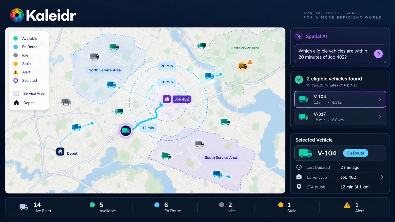
Live fleet tracking becomes more useful when operational eligibility and data freshness are visible alongside the current vehicle position.
Why Is Live Fleet Tracking More Than a Moving Dot?
A basic tracker answers where the vehicle is. A useful fleet product also asks which vehicles are active, which assets have not reported, which field team is inside a service region, which delivery is approaching a customer, and which vehicle is nearest to an incident and still eligible for the job. Those questions combine live location, asset identity, operational status, job or route context, service geography, and data freshness. Kaleidr's homepage names Live Fleet Tracking as an AI-driven customer journey: see where vehicles are now, follow them live, and open their history (Kaleidr, 2026). A moving marker without that state is a rendering problem, not a location-intelligence product.
Geotab's 2026 GPS-tracking guide tells buyers to evaluate refresh rate, connectivity options, software integrations, and data quality when they choose a fleet tracker (Geotab, 2026). That page describes Geotab's own device-selection guidance. A vendor account of tracker features is not a Kaleidr scoring model, and a faster refresh rate by itself does not decide which vehicle should take a job.
Telematics owns facts such as GPS position, speed, ignition, device signals, timestamps, and connectivity. Dispatch or fleet management owns the assigned job, the route, the driver or technician, the schedule, availability, and maintenance status. The map shows the current position, the route, service areas, jobs, alerts, and the selected asset. Spatial AI helps interpret a question such as which active technician is closest to a customer and inside the correct territory. The language model should not invent the vehicle state, the dispatch assignment, or the route. Location intelligence versus spatial AI separates the geographic decision layer from the language model that queries it.
Which Systems Should Own the Fleet State?
A production path runs from the vehicle or asset device into the telematics or fleet platform, then through an authorized current-state feed. The host normalizes that feed into live spatial state: a stable asset ID, a position, a status, a freshness timestamp, and a service area. Kaleidr Studio or the host map draws that state. Spatial AI turns a natural-language request into structured filters and spatial calculations, and the host system validates any assignment or other operational action. The operational system owns the facts. The map and the AI layer make those facts understandable.
Kaleidr Studio currently describes real-time analysis that overlays live data layers and tracks vehicles, fleets, and live feeds as the underlying data changes (Kaleidr, 2026). The same page documents custom basemaps, 3D terrain and buildings, reusable presets, and branding controls. Studio is a visual authoring layer for a branded fleet experience. The fleet or telematics platform remains the source of current positions and operational state.
Kaleidr's AI product page says teams can add AI-powered search, insights, and visualization to a map without rebuilding the existing platform (Kaleidr, 2026). Developer docs for Chat describe attaching that conversational layer to a map the host already renders, rather than replacing the renderer (Kaleidr, 2026). Kaleidr Enterprise currently describes location-intelligence infrastructure with inference APIs, ranking systems, analytics, and deployment support, and it lists chat, editing, custom tiles, and embeddable viewers among the products a host can add (Kaleidr, 2026). Those public pages do not document a telematics hardware service, a driver-behavior platform, a fuel system, a maintenance system, or a universal dispatch optimizer.
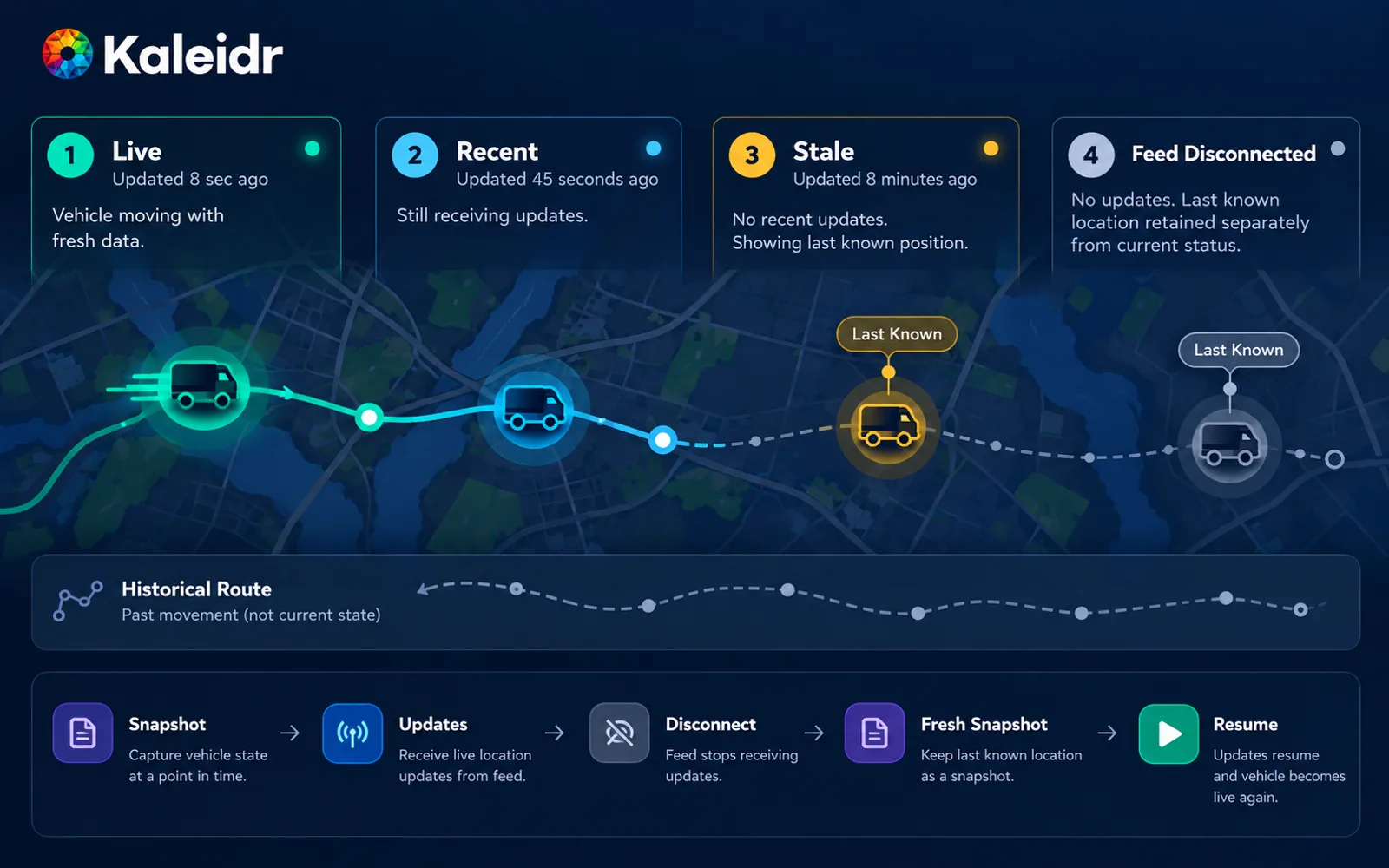
The fleet systems own the facts and operational actions; Spatial AI interprets the question and makes the live map easier to use.
Every moving asset needs one canonical identifier shared by telematics, dispatch, the map, analytics, and the AI layer, because a vehicle can change drivers, jobs, and coordinates many times in a shift. Coordinates may update every few seconds. The identity should not. A stable ID preserves selection, details, route context, history, alerts, and the reference an operator uses in a question. A new anonymous marker for every GPS ping breaks that continuity. Grounded spatial AI for business data makes the same demand for other location decisions: the answer has to come from authorized records, not from the language model's memory of a city.
How Should Freshness and History Stay Separate?
A live map answers where the asset is now. A history view answers where the asset has been. Current state carries the latest authorized position, status, and update time. Historical state is a separate breadcrumb or playback layer, muted so it cannot be mistaken for the live marker. Mixing the two without a label makes yesterday's route look like today's position.
Freshness belongs in the meaning of the marker. A useful scale distinguishes a live update from a recent one, a stale last-known position, and a feed that has disconnected. The last-known location should stay on the map when the product still has it, and the interface should say that the position is no longer certain. Geotab's selection guidance already treats refresh rate as part of tracker choice. The map product has to show the age of the record the tracker actually delivered, not only the cadence the buyer hoped to purchase.
A missing message is not proof that the vehicle stopped. The device may be in a tunnel, out of cellular coverage, powered down, or failing. The product should keep the last authorized position, label it as last-known, and separate a feed failure from a confirmed stop. A later snapshot can resume the live state when messages return. Ordered updates matter: an older message that arrives late should not overwrite a newer position. Coverage that ignores age will treat a nearby-but-stale asset as more eligible than a farther asset that reported moments ago.
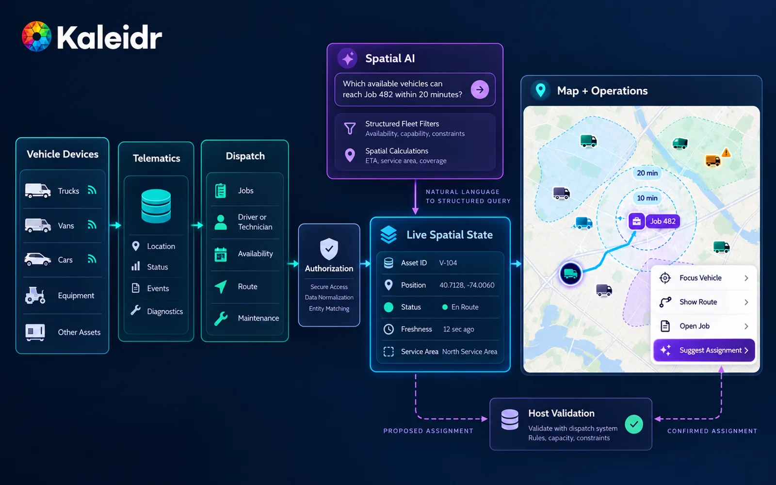
A moving marker is trustworthy only when the map also communicates freshness and connection health.
Near real time is often enough, and the right cadence follows the decision. Dispatch during an incident may need updates on the order of seconds. A field-service board can stay useful at a slower pace. A parked asset or a trailer that moves rarely can wait longer. Sub-second refresh belongs to specialized control systems, not to every customer-facing fleet map. Real-time maps in Kaleidr Studio covers how a branded canvas stays stable while the operational feed changes underneath it. Live fleet tracking uses that pattern and adds eligibility, service geography, and audience policy.
How Should Internal and Customer Fleet Views Differ?
One authoritative fleet state should feed more than one map. An internal operations view can show exact position, driver or technician identity, the assigned job, route deviation, service territory, a maintenance alert, and freshness. A customer tracking view should show the assigned vehicle, a location precision the policy allows, delivery or service status, an ETA from the system that owns it, the latest update time, and a support action. An audience and authorization layer sits between the shared state and both views. The customer should not be able to query the rest of the fleet.
ETA and assignment stay with the host. A routing or dispatch system that already computes arrival time remains the source of that number. Spatial AI can explain a grounded ETA. Spatial AI should not invent one from a marker and a straight line. Identifying eligible vehicles is a screen. Writing the assignment, changing a route, or sending a command to a vehicle remains a host action unless the organization has validated an automated rule and kept a human override. An enterprise Spatial AI pilot uses the same discipline: prove one job before scaling the workflow.
The UK Information Commissioner's Office says employers must inform workers and passengers of any vehicle monitoring, and that monitoring during private use will rarely be justifiable when a work vehicle is allowed for personal use (Information Commissioner's Office, 2026). The same page says this guidance is under review after the Data (Use and Access) Act. That passage is UK worker-monitoring guidance, not a Kaleidr privacy product, and other jurisdictions need their own legal review. Precise vehicle history that can be linked to a person is not ordinary anonymous map data.
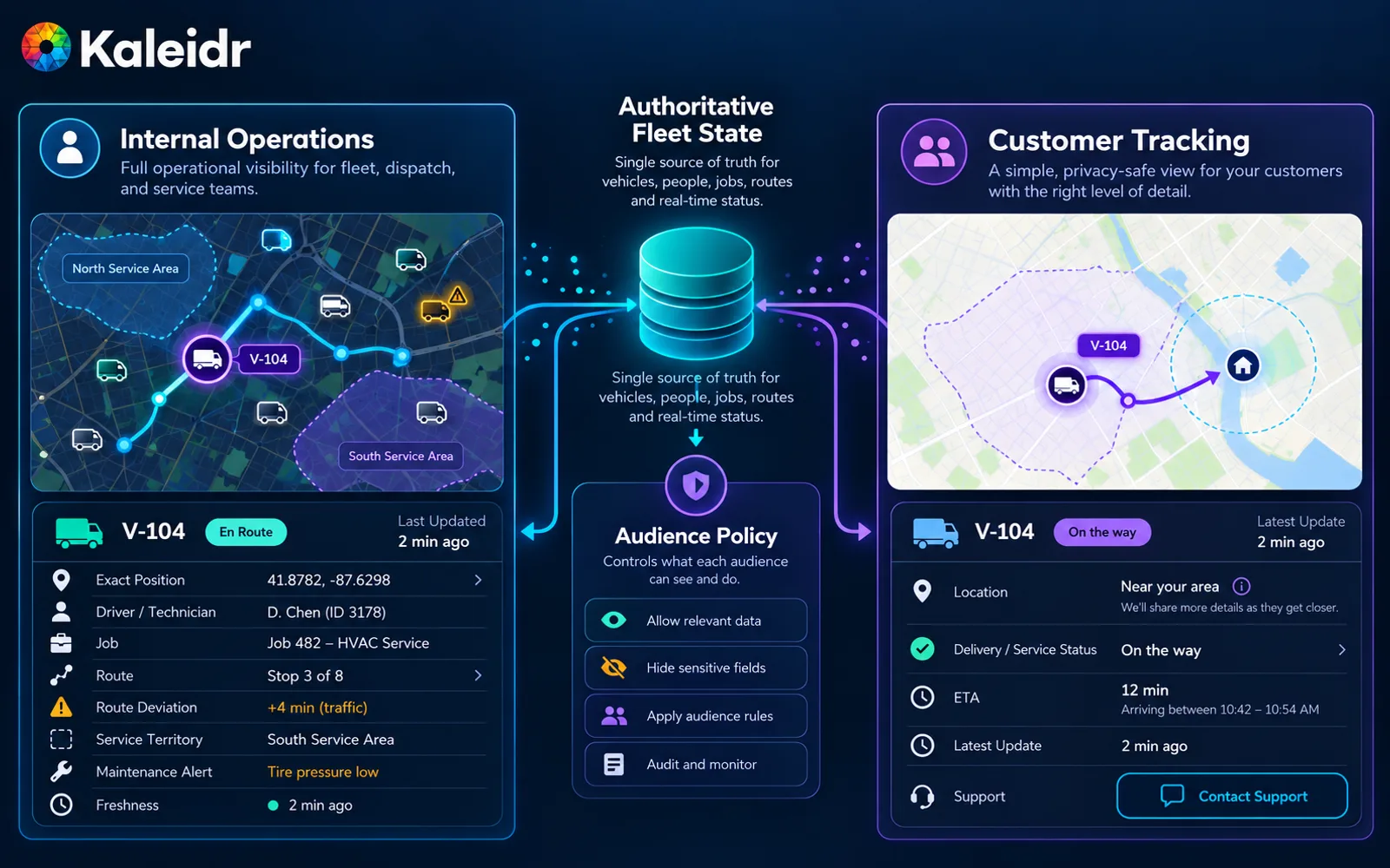
Internal and customer-facing fleet maps can share a source while exposing different fields, precision, and actions.
How Should Teams Pilot Live Fleet Tracking?
A practical pilot starts with one metro or one service line and the current fleet state the host already trusts. Load stable asset IDs, status, and update times. Draw the service areas the business already uses. Filter on eligibility before ranking by distance or travel time. Attach Spatial AI only after those calculations return the same candidates an operator would accept. Measure feed age, stale-asset rate, and whether a dispatcher can explain the shortlist, rather than marker count or the number of questions asked.
The following mistakes are editorial. Real teams should fill the same columns from the telematics feed, the dispatch system, and the audience policy they already govern. A fleet map that hides freshness or eligibility will not survive an operations review.
| Mistake | What goes wrong | What to do instead |
|---|---|---|
| Treat every ping as a new asset | Selection, history, and AI references break | Keep one stable asset ID |
| Hide the update time | A stale marker looks live | Show freshness and connection health |
| Rank by distance first | An ineligible vehicle wins | Filter status, territory, and job rules first |
| Share one live payload | Customers see internal fields | Split views through an audience policy |
| Let the language model assign | Dispatch loses the system of record | Keep assignment on the host, with a human override |
Explore Kaleidr Studio to author a branded map with live layers for vehicles and fleets the business already operates. Explore Kaleidr Enterprise to attach conversational Spatial AI, ranking, and deployment support to that map. The telematics platform, the dispatch system, and the teams that own them still decide what the fleet does next.
FAQs
What is live fleet tracking?
Live fleet tracking shows the current or near-current position and status of vehicles or mobile assets on a map, using GPS or telematics data from a fleet platform, together with job context, service geography, and the age of each update. A shortlist of eligible vehicles is a screen, not an automatic dispatch.
What does Spatial AI add to fleet tracking?
Spatial AI can interpret a natural-language fleet question, apply structured operational and geographic filters, and explain grounded results on the map. Spatial AI should not replace the telematics or dispatch systems that own vehicle state, routes, and assignments.
Is fleet tracking the same as route optimization?
No. Fleet tracking focuses on current asset state, freshness, and movement. Route optimization assigns or sequences routes and stops. The two can work together, and they require different systems.
Does live always mean second-by-second updates?
No. The appropriate refresh cadence depends on the decision. Some dispatch workflows need updates on the order of seconds, while parked assets or infrequent movers can use a slower cadence. The map should still show how old each position is.
Why does a fleet map need timestamps?
A marker can remain visible after the underlying feed becomes stale. A source timestamp lets the product distinguish a current position from an old last-known position, and a missing message from a confirmed stop.
Can AI assign the nearest vehicle automatically?
Spatial AI can help identify eligible candidates from structured fleet state. Assignment should remain controlled by the host dispatch system unless the organization has explicitly validated automated rules and kept a human override.
Should a customer see the exact vehicle location?
Not always. Some customer experiences only need route progress, an authoritative ETA, or a coarser location. Exact live position can raise worker-monitoring, privacy, or security concerns, and the audience policy should decide the precision.
Can Kaleidr Studio show moving fleet assets?
Kaleidr Studio's current product page describes live data layers and tracking vehicles, fleets, and live feeds as the underlying data changes. The fleet or telematics platform remains the source of those positions.
Does Kaleidr replace a telematics provider?
No. Public Kaleidr pages describe branded maps, live visualization, conversational map AI, and enterprise APIs. They do not document a telematics hardware service or a universal dispatch optimizer. The telematics or fleet-management system should remain authoritative for GPS and operational state.
Can Kaleidr AI attach to an existing fleet map?
Kaleidr's current Chat documentation describes attaching the conversational layer to a map the host already renders, rather than replacing the renderer. The host application continues to govern asset state and operational actions.
References
- Kaleidr. AI-Powered Map Experiences for Business. Accessed 24 September 2026. https://kaleidr.com/
- Geotab. Identifying the Best GPS Tracking Devices for Your Fleet: A Comprehensive Guide [2026]. 28 April 2026. https://www.geotab.com/blog/gps-tracking-devices/
- Kaleidr. AI Map Maker for Branded Interactive Maps. Accessed 24 September 2026. https://kaleidr.com/studio
- Kaleidr. AI Map Chat for Customer Discovery. Accessed 24 September 2026. https://kaleidr.com/ai
- Kaleidr. Chat — Attach AI to Your Map. Developer documentation. Accessed 24 September 2026. https://docs.kaleidr.com/sdk/chat-attach
- Kaleidr. Location Intelligence APIs and Map SDK. Accessed 24 September 2026. https://kaleidr.com/enterprise
- Information Commissioner's Office. Specific data protection considerations for different ways or methods of monitoring workers. Accessed 24 September 2026. https://ico.org.uk/for-organisations/uk-gdpr-guidance-and-resources/employment/monitoring-workers/specific-data-protection-considerations-for-different-ways-or-methods-of-monitoring-workers/
- Kaleidr. Real-Time Maps in Kaleidr Studio. Accessed 24 September 2026. https://kaleidr.com/blog/real-time-maps-in-kaleidr-studio
- Kaleidr. Location Intelligence vs. Spatial AI. Accessed 24 September 2026. https://kaleidr.com/blog/location-intelligence-vs-spatial-ai
- Kaleidr. Grounded Spatial AI for Business Data. Accessed 24 September 2026. https://kaleidr.com/blog/grounded-spatial-ai-business-data
- Kaleidr. Enterprise Spatial AI Pilot Before Scaling. Accessed 24 September 2026. https://kaleidr.com/blog/enterprise-spatial-ai-pilot-before-scaling
@misc{kaleidr_live_fleet_home_2026,
  title  = {AI-Powered Map Experiences for Business},
  author = {{Kaleidr}},
  year   = {2026},
  note   = {Accessed 24 September 2026},
  url    = {https://kaleidr.com/}
}

@misc{geotab_gps_tracking_2026,
  title  = {Identifying the Best GPS Tracking Devices for Your Fleet: A Comprehensive Guide [2026]},
  author = {{Geotab}},
  year   = {2026},
  month  = apr,
  url    = {https://www.geotab.com/blog/gps-tracking-devices/}
}

@misc{kaleidr_live_fleet_studio_2026,
  title  = {AI Map Maker for Branded Interactive Maps},
  author = {{Kaleidr}},
  year   = {2026},
  note   = {Accessed 24 September 2026},
  url    = {https://kaleidr.com/studio}
}

@misc{kaleidr_live_fleet_ai_2026,
  title  = {AI Map Chat for Customer Discovery},
  author = {{Kaleidr}},
  year   = {2026},
  note   = {Accessed 24 September 2026},
  url    = {https://kaleidr.com/ai}
}

@misc{kaleidr_chat_attach_fleet_2026,
  title  = {Chat -- Attach AI to Your Map},
  author = {{Kaleidr}},
  year   = {2026},
  note   = {Developer documentation; accessed 24 September 2026},
  url    = {https://docs.kaleidr.com/sdk/chat-attach}
}

@misc{kaleidr_enterprise_live_fleet_2026,
  title  = {Location Intelligence APIs and Map SDK},
  author = {{Kaleidr}},
  year   = {2026},
  note   = {Accessed 24 September 2026},
  url    = {https://kaleidr.com/enterprise}
}

@misc{ico_vehicle_monitoring_2026,
  title  = {Specific data protection considerations for different ways or methods of monitoring workers},
  author = {{Information Commissioner's Office}},
  year   = {2026},
  note   = {Accessed 24 September 2026; guidance under review},
  url    = {https://ico.org.uk/for-organisations/uk-gdpr-guidance-and-resources/employment/monitoring-workers/specific-data-protection-considerations-for-different-ways-or-methods-of-monitoring-workers/}
}

@misc{kaleidr_realtime_maps_2026,
  title  = {Real-Time Maps in Kaleidr Studio},
  author = {{Kaleidr}},
  year   = {2026},
  note   = {Accessed 24 September 2026},
  url    = {https://kaleidr.com/blog/real-time-maps-in-kaleidr-studio}
}

@misc{kaleidr_li_vs_spatial_ai_fleet_2026,
  title  = {Location Intelligence vs. Spatial AI},
  author = {{Kaleidr}},
  year   = {2026},
  note   = {Accessed 24 September 2026},
  url    = {https://kaleidr.com/blog/location-intelligence-vs-spatial-ai}
}

@misc{kaleidr_grounded_spatial_ai_fleet_2026,
  title  = {Grounded Spatial AI for Business Data},
  author = {{Kaleidr}},
  year   = {2026},
  note   = {Accessed 24 September 2026},
  url    = {https://kaleidr.com/blog/grounded-spatial-ai-business-data}
}

@misc{kaleidr_enterprise_pilot_fleet_2026,
  title  = {Enterprise Spatial AI Pilot Before Scaling},
  author = {{Kaleidr}},
  year   = {2026},
  note   = {Accessed 24 September 2026},
  url    = {https://kaleidr.com/blog/enterprise-spatial-ai-pilot-before-scaling}
}