
Local amenities are nearby places, services, and facilities that matter to a person or product workflow. Relevant categories depend on the user, geography, source data, and decision—not one universal checklist. A useful amenity map needs clear categories, reliable place identity, distance or travel-time context, transparent ranking, and an explanation of why each place matters.
The sections below cover taxonomy, spatial relationships, place sources, Kaleidr discovery paths, ranking, and common failures. Related product context lives on Kaleidr Spatial AI and Kaleidr Studio. For tourism and retail patterns, see the AI-powered tourism map and AI store locator with map chat guides.
Amenity-mapping essentials
- Task first: Choose categories from the decision, not every available point of interest.
- Context, not grade: Prefer inspectable facts over opaque neighborhood scores.
- Right geometry: Match straight-line distance, travel time, containment, or along-route relevance to the question.
- Stable places: Preserve IDs, source, coordinates, and freshness.
- Grounded AI: Interpret intent in language; resolve amenities through approved place systems.
What Counts as a Local Amenity?
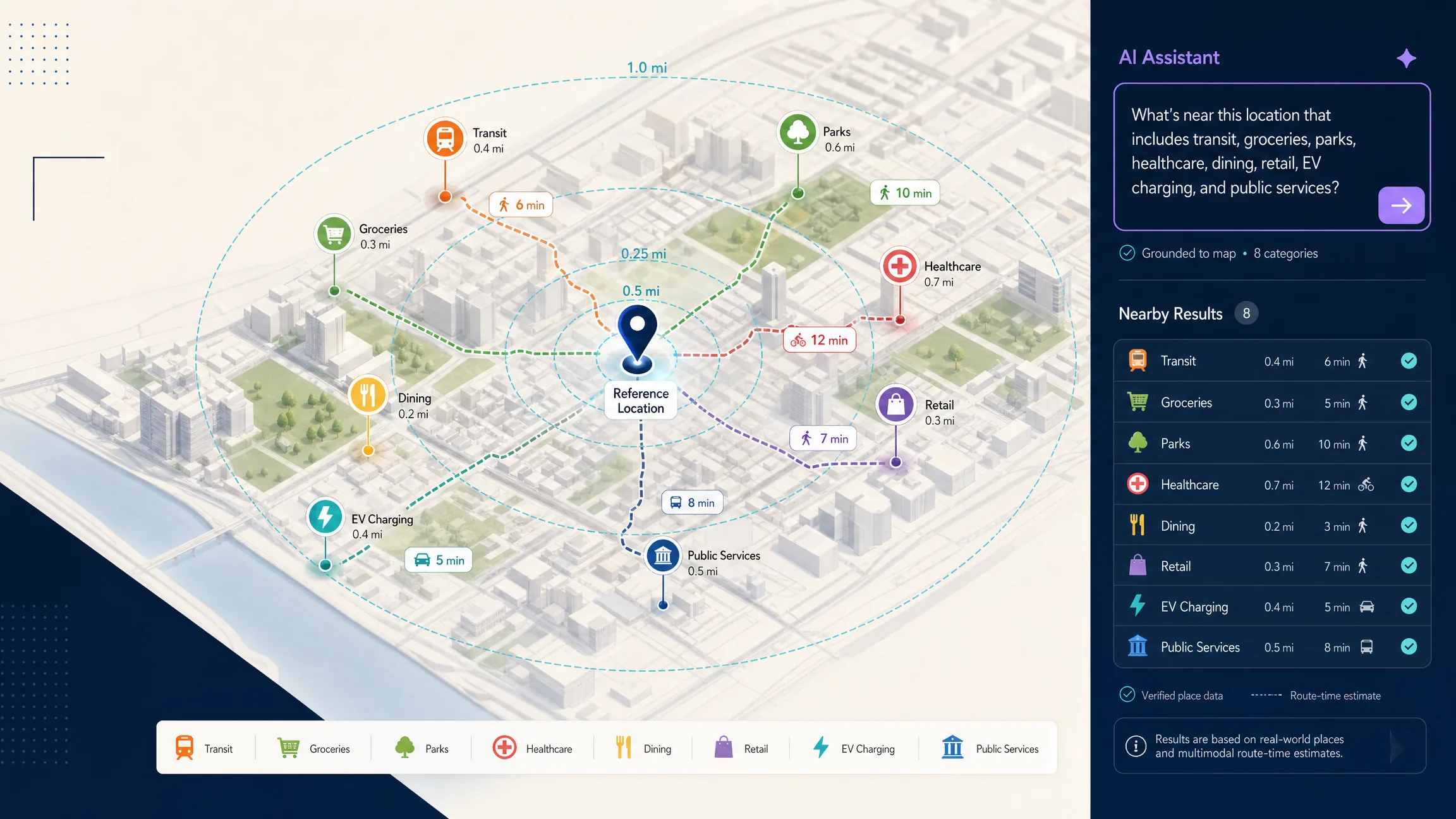
In practical map products, an amenity is a place or service that contributes useful context around another location. Common examples include grocery stores, pharmacies, healthcare facilities, transit stops, parks, restaurants, schools, banks, libraries, EV charging, parking, post offices, fitness facilities, cultural venues, and everyday retail services. The exact taxonomy belongs to the data provider and to the product team’s user-facing groups, not to one fixed industry checklist.
OpenStreetMap uses the top-level amenity=* tag for many useful facilities, including banks, pharmacies, schools, toilets, and other services, while other relevant places live under keys such as shop=*, leisure=*, and tourism=*. A complete amenities experience should not assume every useful place belongs to one technical category; see the OpenStreetMap amenity key and Map Features reference. Google Places uses a different place-type system: Nearby Search can search within a geographic area using included or excluded place types and rank results by distance or popularity (Nearby Search in Places API). The classification system therefore belongs to the selected provider, while the product team still decides which categories are meaningful to its users.
Why Are Local Amenities Context Rather Than a Quality Score?
A common mistake is to compress nearby places into one opaque label such as “excellent neighborhood amenities.” That statement may hide several different judgments: one user may value rail access, another parks or pharmacies, a retail operator parking and complementary stores, and a hotel guest restaurants within walking distance. A stronger product presents inspectable signals—grocery stores within a stated radius, nearest rail walk time, pharmacies within a driving threshold, parks inside the current search area, or nearest charging distance—rather than a generalized grade. An amenity score can still help, but categories, weights, geographic method, and data source should be documented so users can judge the claim.
How Do Amenity Needs Differ by Use Case?
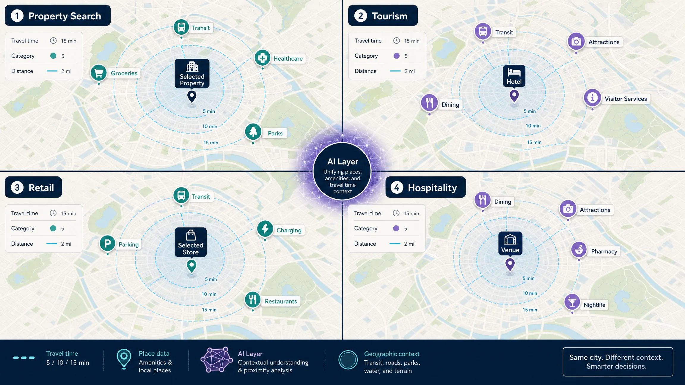
The same place can matter differently depending on the product. Property search often surfaces transit, groceries, parks, healthcare, and verified building services. Tourism and hospitality lean on attractions, dining, transit, museums, parks, pharmacies, and visitor services. Retail may emphasize parking, transit, complementary stores, restaurants, and charging. Campus and events maps prioritize dining, libraries, parking, hotels, food, and emergency services. Operations workflows may need fuel, depots, hospitals, charging, and repair locations. The product should choose categories from the actual task instead of showing every available point of interest.
| Use case | Common amenity signals | Why they matter |
|---|---|---|
| Property search | Transit, groceries, parks, healthcare, verified building services | Adds objective location context around a listing |
| Tourism | Attractions, dining, transit, museums, parks, visitor services | Helps visitors understand what is nearby and plan a trip |
| Retail | Parking, transit, complementary stores, restaurants, charging | Helps customers reach a location and helps teams evaluate surroundings |
| Hospitality | Dining, attractions, nightlife, transit, pharmacies | Helps guests make decisions around a hotel or venue |
| Campus | Dining, libraries, parking, transit, accessibility services | Helps students and visitors navigate daily needs |
| Events | Parking, transit, hotels, food, emergency services | Supports arrival planning and visitor logistics |
| Operations | Fuel, depots, hospitals, charging, repair, service locations | Supports field and logistics decisions |
How Does Amenity Mapping Work?
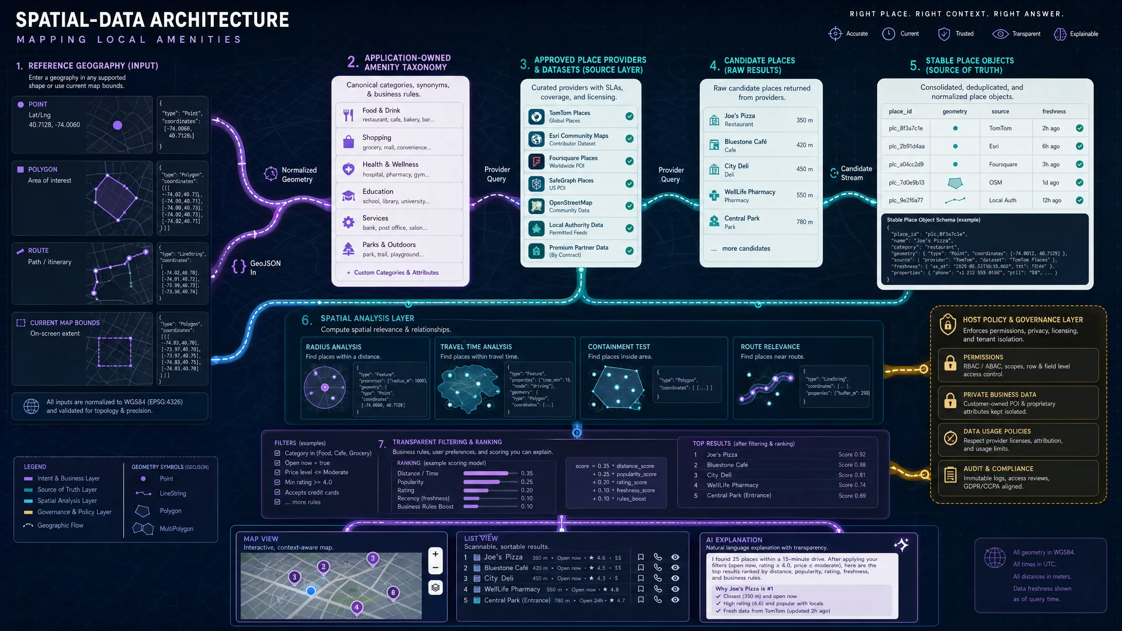
A useful amenity map usually follows a layered pipeline: start from a reference location or area, select amenity categories, query an authoritative place search or dataset, retain stable place identities and coordinates, apply distance, travel-time, or containment analysis, apply product-specific ranking and filtering, then present synchronized map, list, and explanation outputs. Each layer has a different owner. The reference geography can be a property, hotel, store, route, polygon, neighborhood, or current map view. The place source returns candidates and supported attributes. Spatial operations measure relationship. Product policy decides relevant categories, thresholds, ranking, and eligibility. The map renderer displays selected places. An AI layer may interpret flexible intent and explain grounded results. The host application owns users, workflow, permissions, private data, and final actions. The language model should not invent local amenities; it should coordinate retrieval from the systems responsible for place facts.
| Layer | Responsibility |
|---|---|
| Reference geography | Property, hotel, store, route, polygon, neighborhood, or current map view |
| Place source | Returns candidate places and supported attributes |
| Spatial operation | Measures distance, travel time, containment, or relation to a route |
| Product policy | Determines relevant categories, thresholds, ranking, and eligibility |
| Map renderer | Displays the selected places and geographic context |
| AI layer | Interprets flexible user intent and explains grounded results |
| Host application | Owns users, workflow, permissions, private data, and final actions |
How Do Distance, Travel Time, and Containment Differ?
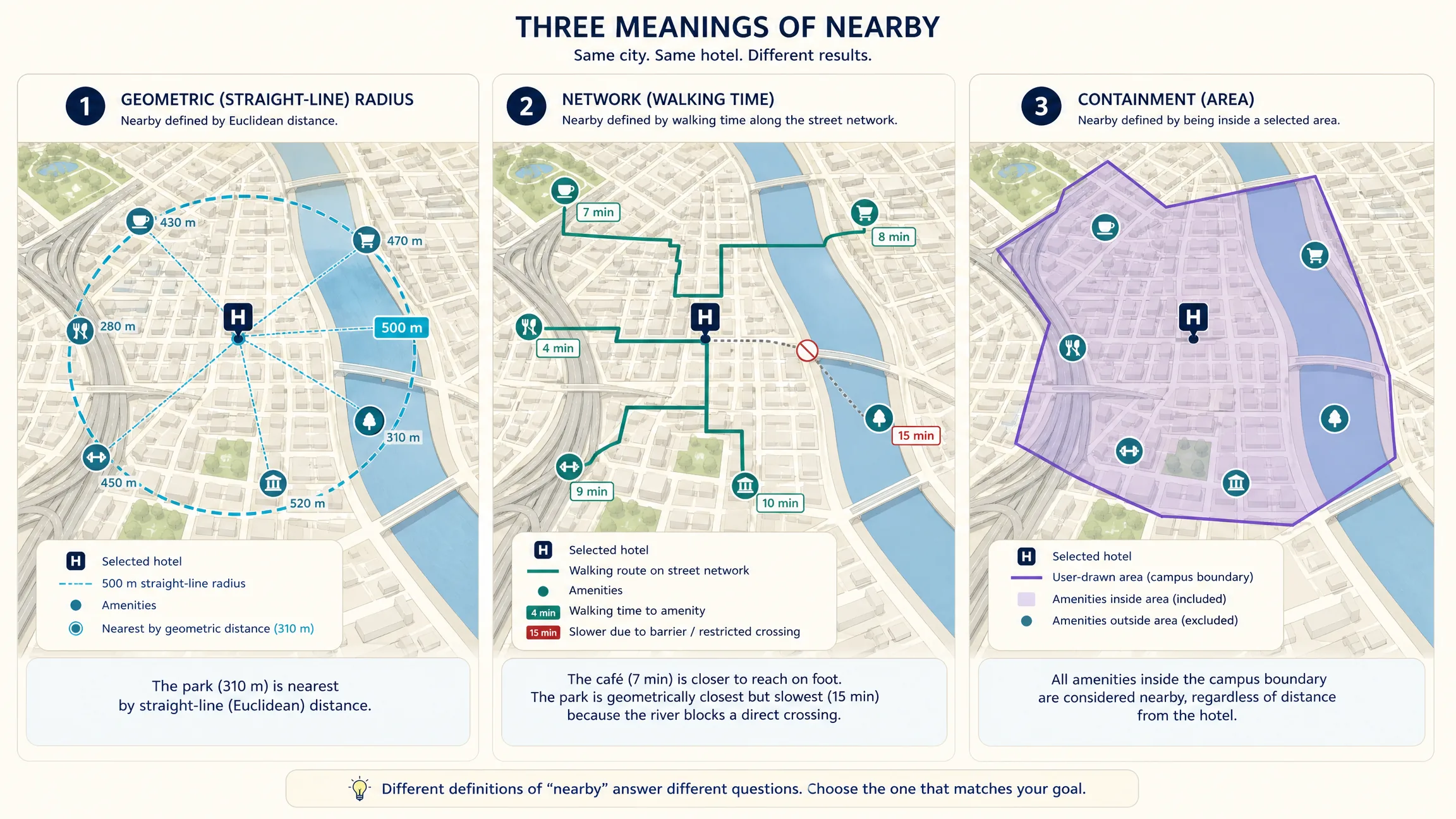
Two amenities can be geographically close but operationally far apart. A grocery store a few hundred meters away across a river, highway, rail yard, or restricted property may be less accessible than a store farther away along a direct street network. Straight-line distance is useful for coarse discovery, bounding candidates, simple radius searches, and low-cost first-stage filtering. Walking, driving, cycling, or transit time is useful when the actual route matters—pharmacies within a ten-minute walk, chargers within a fifteen-minute drive, or cafes within twenty minutes by transit. Containment is useful when the request is geographic rather than distance-based: amenities inside a campus, stores within a shopping district, visitor services inside a park, or restaurants inside a user-drawn polygon. Along-route relevance supports navigation and trip planning for fuel, food with a small detour, charging along a drive, or attractions between destinations. Do not label every nearby-place query as “within X minutes” unless a routing or travel-time system actually calculated that value.
How Should Teams Define Taxonomy and Place Identity?
Provider taxonomies change, overlap, and differ from product language. Users may ask for groceries, transit, healthcare, parks, dining, shopping, education, fitness, EV charging, or parking, while providers expose much more granular types. Create an application-owned taxonomy that maps provider categories into stable user-facing groups. A conceptual configuration can hold labels, provider type lists, and default radii per category; treat that shape as product pseudocode, not a current Google, OpenStreetMap, or Kaleidr schema. The benefit is interface stability while adapters translate into each approved data source.
A local amenity is more than a label and coordinate. A production place object should retain enough information to distinguish one real-world entity from another: stable provider or internal ID, name, category, coordinates, formatted address, source, source-specific metadata, and update time when available. Stable identity helps prevent duplicate pins, conflicting records, incorrect click-through links, mismatched photos, and repeated analytics events for the same place.
{
  "placeId": "provider_or_internal_id",
  "name": "Example Pharmacy",
  "category": "pharmacy",
  "coordinates": [-77.0365, 38.8977],
  "address": "Example address",
  "source": "approved_place_provider",
  "updatedAt": "2026-08-08T00:00:00Z"
}
How Can Google Places and OpenStreetMap Supply Amenities?
Google’s Places API (New) supports Nearby Search through a POST request to places:searchNearby. The request specifies a geographic restriction and can include or exclude place types, while a field mask controls which place fields the response returns (Nearby Search documentation; Places API overview). Google notes that Nearby Search can rank by distance or popularity and that requested fields affect billing, so request only the fields the product needs. Validate the exact field mask, place type, billing configuration, and key restrictions before production deployment, and keep server credentials on the server.
curl -X POST \
  -H "Content-Type: application/json" \
  -H "X-Goog-Api-Key: YOUR_SERVER_SIDE_GOOGLE_KEY" \
  -H "X-Goog-FieldMask: places.id,places.displayName,places.location,places.primaryType" \
  https://places.googleapis.com/v1/places:searchNearby \
  -d '{
    "includedTypes": ["pharmacy"],
    "maxResultCount": 10,
    "locationRestriction": {
      "circle": {
        "center": { "latitude": 38.8977, "longitude": -77.0365 },
        "radius": 1500
      }
    }
  }'
OpenStreetMap can provide a broad open geographic dataset, but an application must understand its tagging model. The amenity=* key covers many public and commercial facilities, while other relevant concepts live under shop=*, leisure=*, tourism=*, public_transport=*, and some transport-related highway=* features. OpenStreetMap describes physical features through tags attached to nodes, ways, and relations; the flexible model is powerful, but the host application must map many tags into a smaller user-facing taxonomy. Before building a commercial product on OpenStreetMap-derived data, review the exact data source, license, attribution, update process, and any third-party tile or geocoding service terms separately.
How Does Kaleidr Support Amenity Discovery?
Kaleidr is useful when the product needs to move beyond a fixed category picker and let users express contextual location intent. Kaleidr Spatial AI is currently positioned around discovering places with AI-powered context and recommendations, creating maps, personalizing them, and sharing the result; its map interface is designed for questions expressed in natural language rather than keyword search alone. Amenity questions can ask for pharmacies and grocery stores near a hotel, parks and cafes near properties, EV charging and food near a route, visitor services around a venue, or everyday services inside a drawn area. The strongest implementation keeps responsibilities separate: Kaleidr interprets geographic intent, approved place systems resolve candidate amenities, the host application applies permissions and business rules, and the map presents the grounded result. Kaleidr’s developer documentation currently supports attaching AI chat to a Mapbox, Google Maps, or MapLibre map an application already runs, so the host team does not need to replace the renderer to add conversational place discovery.
Kaleidr Studio is a prompt-first map authoring environment built around Prompt → Process → Refine → Deploy. Studio currently supports custom design, content, style, interaction, reusable layers, datasets, branded basemaps, 3D visualization, and real-time data layers. A useful starting prompt defines audience, prioritized categories, map behavior, and goal—for example, an amenities map for a business-trip stay that groups rail, restaurants, pharmacies, groceries, and parks around selected hotels. The prompt should define purpose and categories; the creator should still review every place and source before publishing. Housing products can show objective signals such as transit, groceries, parks, pharmacies, healthcare, verified building services, EV charging, and parking, but should avoid vague demographic judgments such as “best neighborhood for families,” “safe area,” or “desirable demographic profile.” Show the actual selected criteria and source data instead.
How Should Amenities Be Ranked, Freshened, and Presented?
Do not rank amenities with a mysterious AI score when a clear rule will work. A transparent pipeline can run category match, geographic eligibility, data freshness, user-selected travel mode, distance or travel time, optional provider ranking, and product-specific tie breakers. If a guest asks which grocery stores are easiest to reach without a car, a reasonable product might rank by walk or transit accessibility, the requested threshold, current opening information when the approved source supports it, and confidence plus freshness. The explanation should expose the actual reason—walk time, distance, and category—rather than an opaque score.
Amenity data changes: places close, move, change category, update hours, alter accessibility, become temporarily unavailable, or appear twice across providers. Define a freshness policy for each important field. Coordinates usually come from an approved place or geographic source; addresses from a place provider or registry; opening hours from a place provider or business-managed source; inventory and eligibility from business systems; travel time from a routing provider; and AI explanation as a derived layer, not an authority. Do not preserve an old AI summary after the underlying place record has changed without revalidation.
On the map, keep categories visible with a compact legend or filter control. Synchronize every marker with an equivalent text result so selecting a card highlights the marker and selecting a marker identifies the corresponding result. Cluster or aggregate at city scale, then reveal individual places as the user zooms. Do not encode importance only by color; use labels, icons, shape, size, text, or focus state alongside color. When a user selects an amenity, keep the reference property, store, hotel, route, or area visible when possible, because the relationship is the useful part of the answer. If a result is ranked by travel time, show the travel time; if by distance, show distance; if it is merely inside a polygon, do not present a fabricated travel estimate.
Which Mistakes Should Teams Avoid?
| Mistake | What happens | Recommended correction |
|---|---|---|
| Treating every nearby place as an amenity | The map becomes noisy and unfocused | Define categories from the user task |
| Treating one provider taxonomy as the UX taxonomy | Users see technical or inconsistent categories | Create an application-owned canonical taxonomy |
| Ranking only by straight-line distance | Results can be close but hard to reach | Use the appropriate travel metric when accessibility matters |
| Presenting an opaque amenity score | Users cannot understand the recommendation | Expose category, distance, travel time, source, and reasons |
| Letting AI invent places | False pins appear authoritative | Resolve amenities through approved place sources |
| Mixing stale and current records | Users see closed or moved places | Define refresh and conflict-resolution policies |
| Showing only a map | Accessibility and comparison suffer | Provide a synchronized text list |
| Loading every category at once | The map becomes dense and expensive | Query or display only task-required categories |
| Hiding the source | Users cannot judge data quality | Preserve source attribution and freshness where appropriate |
| Treating amenity density as causal demand | Business decisions become overstated | Combine amenities with market and operational evidence |
Before release, define the user decision and reference geography, document amenity categories and the canonical taxonomy, test provider-category mapping, retain stable place IDs, verify coordinate order, handle duplicates, review source and attribution, select distance versus travel-time logic, document ranking rules, implement no-result states, synchronize map and list, test clustering and mobile layout, ground AI answers in place data, keep private business data behind authorization, and tie analytics to useful decisions rather than pan counts.
Final Verdict
Local amenities are not a fixed checklist. Amenities are location context selected for a particular user decision. A useful amenity map starts by defining what the user is trying to accomplish, chooses the relevant place categories, resolves real places through approved sources, measures the right geographic relationship, and presents the result transparently. AI can make that workflow more flexible by interpreting questions such as which useful services are near a hotel or which transit, groceries, and parks surround a set of properties. The AI layer should not replace the place database or turn proximity into an unexplained quality score.
For Kaleidr, the strongest amenity workflow combines Spatial AI for natural-language discovery, Studio for authored map experiences, and developer integration when the host product already owns the map, data, and business workflow.
Explore Local Amenities With Kaleidr Spatial AI
Ask contextual location questions and explore places on a live AI-powered map. Try Kaleidr Spatial AI to test amenity-style discovery, then author a publishable amenities experience in Kaleidr Studio when the map needs curated layers, branded design, and a durable share or embed path.
FAQs
What are local amenities?
Local amenities are nearby places, services, or facilities that are useful for a specific person or task, such as groceries, transit, parks, pharmacies, schools, restaurants, parking, or healthcare.
Is there a standard list of local amenities?
No universal list applies to every product. Place providers have their own taxonomies, and the application should map those technical categories into a smaller set that reflects the user’s task.
What is an amenity map?
An amenity map shows useful places or facilities around a reference location, route, or area. A strong amenity map also explains category, distance or travel time, source, and geographic relationship.
How do I find amenities near a location?
Use an approved place dataset or nearby-search service, define the center or search area, request the relevant categories, resolve stable place identities, and rank or filter the results using the metric appropriate to the task.
Is distance enough to compare amenities?
Not always. Straight-line distance is useful for coarse proximity, but walking, driving, cycling, or transit time may better represent real accessibility.
Can AI find local amenities?
AI can interpret a flexible request and coordinate a place search, but the actual amenities should be resolved through reliable place or business data rather than generated from model memory.
How should amenities be ranked?
Use explicit factors such as category match, geographic eligibility, freshness, distance, travel time, and user-selected constraints. Avoid opaque scores when a direct reason can be shown.
Can Kaleidr create an amenities map?
Kaleidr Studio supports prompt-first interactive map creation, layers, datasets, styling, branded basemaps, and publishing. Kaleidr Spatial AI supports natural-language place exploration, while the developer platform can attach AI chat to an existing supported web map.
References
- Google. Nearby Search (New) — Places API. Google Maps Platform documentation. Accessed 8 August 2026. https://developers.google.com/maps/documentation/places/web-service/nearby-search
- Google. Places API Overview. Google Maps Platform documentation. Accessed 8 August 2026. https://developers.google.com/maps/documentation/places/web-service/overview
- Kaleidr. AI Maps You Can Talk To — Spatial AI. kaleidr.com. Accessed 8 August 2026. https://kaleidr.com/ai
- Kaleidr. Create Custom Maps with AI Map Maker. kaleidr.com. Accessed 8 August 2026. https://kaleidr.com/studio
- Kaleidr. Location Intelligence API & Spatial Infrastructure. kaleidr.com. Accessed 8 August 2026. https://kaleidr.com/enterprise
- Kaleidr. Introduction. Kaleidr Developer Docs. Accessed 8 August 2026. https://docs.kaleidr.com/
- OpenStreetMap Wiki. Key:amenity. Accessed 8 August 2026. https://wiki.openstreetmap.org/wiki/Key:amenity
- OpenStreetMap Wiki. Map Features. Accessed 8 August 2026. https://wiki.openstreetmap.org/wiki/Map_features
@misc{google_nearby_search,
  title  = {Nearby Search (New)},
  author = {{Google}},
  note   = {Google Maps Platform documentation; accessed 8 August 2026},
  url    = {https://developers.google.com/maps/documentation/places/web-service/nearby-search}
}

@misc{osm_amenity,
  title  = {Key:amenity},
  author = {{OpenStreetMap Wiki}},
  note   = {Accessed 8 August 2026},
  url    = {https://wiki.openstreetmap.org/wiki/Key:amenity}
}

@misc{kaleidr_spatial_ai,
  title  = {AI Maps You Can Talk To -- Spatial AI},
  author = {{Kaleidr}},
  note   = {Accessed 8 August 2026},
  url    = {https://kaleidr.com/ai}
}

@misc{kaleidr_studio,
  title  = {Create Custom Maps with AI Map Maker},
  author = {{Kaleidr}},
  note   = {Accessed 8 August 2026},
  url    = {https://kaleidr.com/studio}
}

@misc{google_places_overview,
  title  = {Places API Overview},
  author = {{Google}},
  note   = {Accessed 8 August 2026},
  url    = {https://developers.google.com/maps/documentation/places/web-service/overview}
}

@misc{osm_map_features,
  title  = {Map Features},
  author = {{OpenStreetMap Wiki}},
  note   = {Accessed 8 August 2026},
  url    = {https://wiki.openstreetmap.org/wiki/Map_features}
}