
Searching for free places to explore near me needs more than a nearby attraction list. The map must identify genuinely accessible places, verify free versus conditional or paid access, account for hours and travel time, and rank options that fit the moment. Parks, viewpoints, libraries, and similar places can be worth exploring, but “free” should come from current source data rather than category inference.
The sections below cover fee verification, nearby versus reachable, category modeling, ranking, privacy, and saving finds into a map. Related product context lives on Kaleidr Spatial AI and Kaleidr Studio. For the underlying nearby-search architecture, see How to Build a Nearby Places Map for Near Me Search.
Free-discovery essentials
- Verify free: Treat fee status as evidence, not a category guess.
- Check access separately: Free and publicly enterable are different attributes.
- Prefer reachable: Travel time can beat straight-line distance for walk-and-explore tasks.
- Keep unknown unknown: Do not label missing fee data as free.
- Save what works: Discovery becomes durable when selected places become a map.
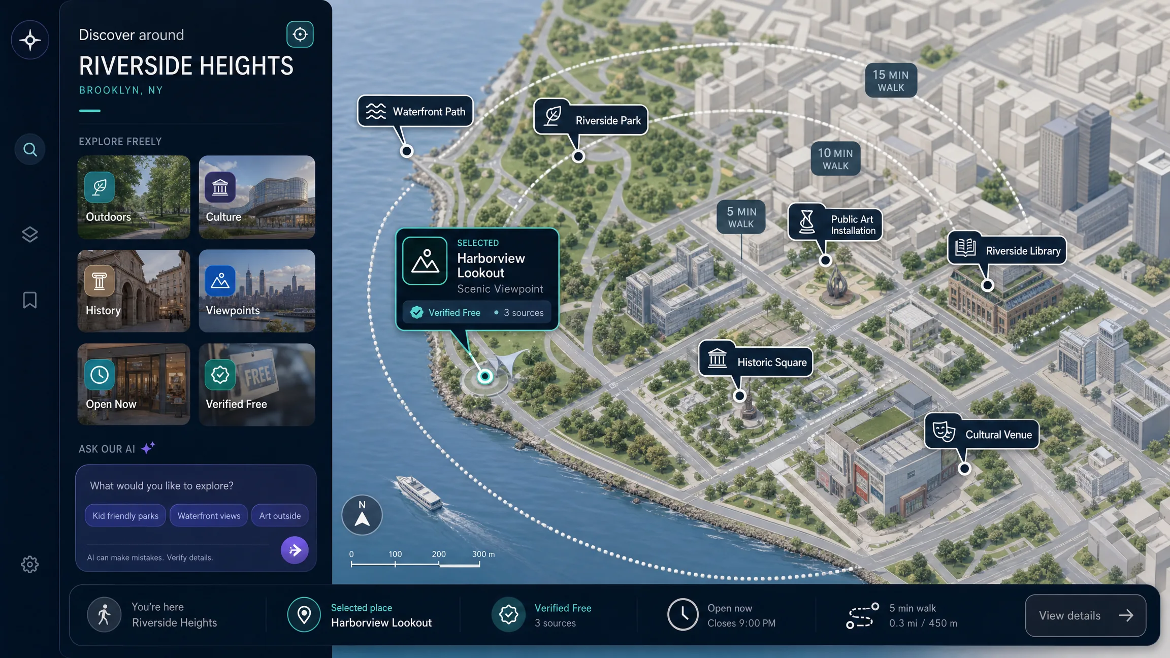
What Counts as Free Places to Explore Near Me?
A free place to explore is a location that a visitor can meaningfully experience without paying a required admission fee for the intended visit. That definition is intentionally narrower than “a place that appears free on a map.” Useful categories to investigate include public parks, trails and greenways, beaches with unrestricted public access, scenic viewpoints, public squares, public art, monuments, libraries, free galleries or museums, historic districts, waterfront walks, community spaces, markets without admission fees, visitor centers, public gardens, architecture walks, and nature areas. The place type alone does not prove free access: a park may charge an entrance or vehicle fee, a museum may be free only on certain days, a garden may require reservations, a beach may charge for parking, or a viewpoint may sit behind a paid attraction.
The strongest discovery workflow therefore treats free access as a verified attribute, not a guess. OpenStreetMap’s tourism model allows tourism features to be combined with access=* and fee=* attributes to describe who can use a place and whether a fee applies, and it supports opening_hours=* for places whose access changes by day or time (Key:tourism; Key:fee; Key:access; Key:opening_hours). These fields are useful signals, but any crowd-sourced dataset can be incomplete or stale, so the product should preserve the source and freshness of important claims.
Why Is “Near Me” More Complicated Than Distance?
The closest place is not always the most useful place. A free park across a river with no nearby pedestrian crossing can rank first by straight-line distance while a slightly farther park ranks first by walking time. A useful local-discovery experience should distinguish straight-line distance, route distance, and travel time. For casual browsing, distance may be enough. For a user asking what can be explored within twenty minutes, travel time is the better constraint. The nearby places map guide explains origin selection, nearby search, map and list synchronization, and ranking in more depth.
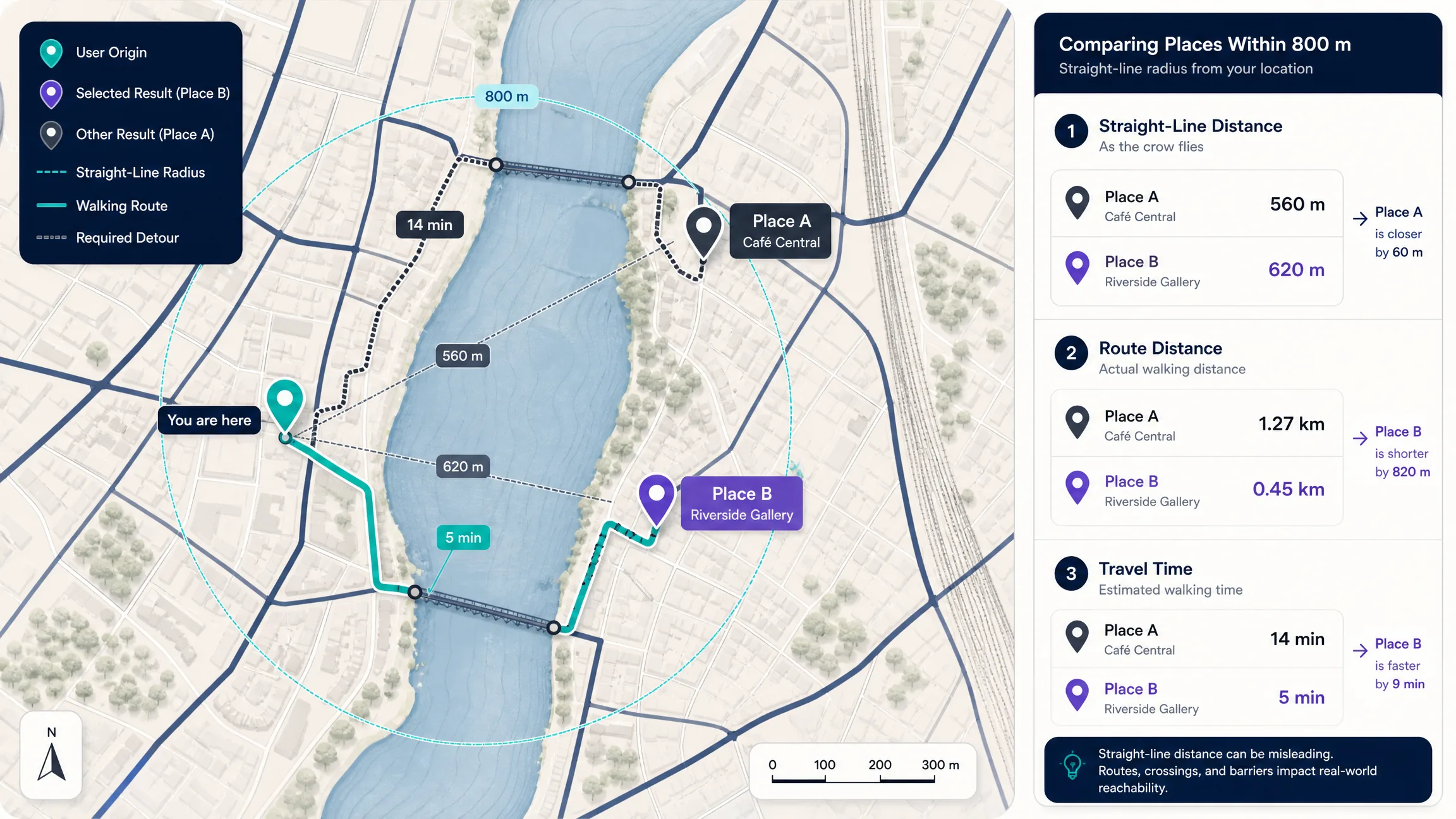
| Signal | What it answers |
|---|---|
| Straight-line distance | How far apart are the coordinates? |
| Route distance | How far must the user actually travel? |
| Travel time | How long will the trip likely take for the selected mode? |
A good discovery map should support more than one way to define “near me.” Browser geolocation can provide a starting point when the user grants permission, but the application should request location only after a clear action, explain why it is useful, handle denial, avoid collecting more precision than needed, and offer another method. Typed city, neighborhood, or address search matters for trip planning, privacy-conscious users, unsupported geolocation, and exploring somewhere other than the current position. Map-selected search helps when the user wants to explore a waterfront, downtown, park district, hotel area, route stop, or neighborhood they plan to visit later. The origin should remain visible and editable rather than disappearing into hidden application state.
How Should Free-Place Categories and Nearby Search Work?
Do not query for one generic category called free_places. Place datasets usually classify the underlying place first. A discovery product can define a canonical taxonomy such as outdoors, culture, urban exploration, and community, then map provider-specific types into that model so several data sources can be combined without exposing provider taxonomies directly to users. The JSON below is conceptual rather than a current Kaleidr, Google, or OpenStreetMap schema.
{
  "outdoors": ["park", "trail", "beach", "viewpoint", "nature_area", "public_garden"],
  "culture": ["museum", "gallery", "library", "public_art", "monument", "historic_site"],
  "urban_exploration": ["public_square", "waterfront", "market", "architecture", "pedestrian_area"],
  "community": ["community_center", "visitor_center", "public_event_space"]
}
A nearby-search service usually starts with a center coordinate, a geographic search restriction, one or more place types, the fields required for the interface, and a ranking rule. Google Places Nearby Search currently accepts one or more place types and a circular locationRestriction, requires a response field mask, and can rank results by popularity or distance (Nearby Search). Adapt the provider key and request architecture to current security guidance. The result answers which matching places are in the search area; it does not automatically answer which of those places are definitely free to visit right now.
curl -X POST \
  -H "Content-Type: application/json" \
  -H "X-Goog-Api-Key: YOUR_SERVER_SIDE_OR_RESTRICTED_KEY" \
  -H "X-Goog-FieldMask: places.id,places.displayName,places.location,places.formattedAddress,places.primaryType" \
  -d '{
    "includedTypes": ["park", "museum", "library"],
    "maxResultCount": 20,
    "locationRestriction": {
      "circle": {
        "center": { "latitude": 38.9072, "longitude": -77.0369 },
        "radius": 5000
      }
    }
  }' \
  "https://places.googleapis.com/v1/places:searchNearby"
Why Must “Free” Be Verified Separately?
A category such as park, museum, beach, gallery, or historic site does not prove fee = none. The application should classify fee evidence separately with states such as verified free, conditionally free, paid, and unknown. Do not collapse unknown into free. Verified free is appropriate when a reliable current source explicitly says no admission fee is required for the relevant visit. Conditionally free covers free days, limited hours, age or resident rules, reservations, membership, or time thresholds. OpenStreetMap supports fee:conditional=* for cases where the usual fee status changes under a condition, which illustrates why a binary free/paid field can be too simple for real places (Key:fee:conditional). When no reliable fee information is available, say so rather than labeling an unknown place free because it looks like a public attraction.
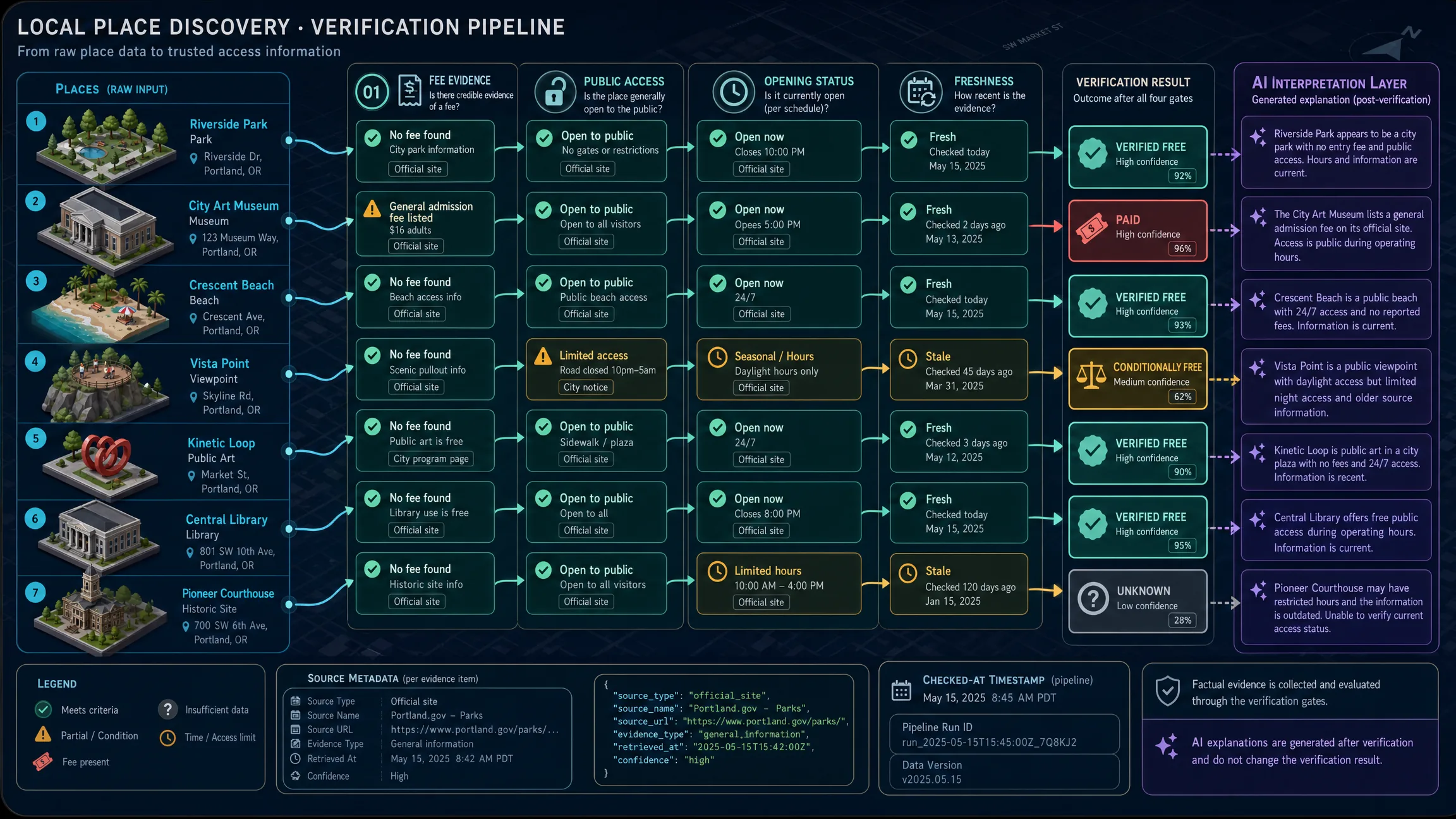
{
  "place_id": "place_123",
  "name": "Example Place",
  "category": "museum",
  "fee_status": "verified_free",
  "fee_source": "official_website",
  "fee_checked_at": "2026-08-11T14:00:00Z",
  "access_status": "public",
  "hours_status": "open",
  "confidence": "high"
}
A place can be free and still not be publicly accessible: private gardens, school fields, residents-only facilities, seasonally closed trails, buildings visible from the street but not open to visitors, and temporarily closed public spaces. OpenStreetMap’s access=* family is designed to describe legal access restrictions on roads, facilities, buildings, shops, amenities, and leisure grounds. For discovery ranking, combine fee status, public access, opening status, and geographic fit. A place should not rank highly merely because it is nearby and free if the user cannot enter it. “Free” is also not enough if the place is closed. Preserve the source, the time information was retrieved or checked, whether current-open status is known, and whether exceptional closures may apply. Prefer “The source reports free admission; check the venue before traveling” over “This place is always free” unless the data supports the stronger claim.
How Should Results Be Ranked, Explained, and Shown?
A local-discovery ranking can combine hard filters, public access, fee evidence, open or usable now, distance or travel time, category match, user intent, and diversity and quality. Hard filters should happen before relevance scoring: exclude prohibited access, places outside the requested area, required fees that conflict with a free-only search, known closures at the requested time, and sources that prohibit the intended use. Then rank the eligible set. A purely popularity-based list can become repetitive; a user asking for free places to explore near me may prefer one viewpoint, one park, one public-art walk, one historic area, and one library rather than five nearly identical parks. Balance category, geography, indoor or outdoor, time required, walking accessibility, and preferences without using diversity as an excuse to surface weak or unverified places.
AI becomes useful after the factual place layer exists. Users can ask for free outdoor places for an hour, free indoor places because it is raining, free historic places within walking distance, waterfront options without admission, short evening walks, or viewpoints and public art near a hotel. The AI layer interprets the constraints, while authoritative place and access data should still validate identity, coordinates, fee status, access, hours, route, and operational facts. Kaleidr Spatial AI is designed around natural-language place exploration and map-aware recommendations, including grounding place answers on a business’s inventory, brand voice, and policies rather than relying on generic web search alone. AI should decide what evidence is relevant to the question; it should not invent the evidence.
The map should make the reasoning visible with category chips, explicit fee states such as verified free, free at selected time, and fee unknown, time filters, travel constraints, a deliberate “Search this area” action, and a synchronized accessible list. Each card can show place name, category, distance or travel time, fee evidence, opening status, source, a short match reason, and a save or share action. Separate the factual record from any generated explanation so the explanation can be regenerated while fee, access, and hours remain traceable to their sources.
How Do Discovery, Saving, Privacy, and Accessibility Fit Together?
Local discovery becomes more useful when the user can save results into a durable object: discover, select places, save to map, reorder or group, and share. Find three free places around a neighborhood, save them to a map, optionally add a cafe or restaurant separately, order the places into a walk, and share the map. Kaleidr currently lets users explore places, create maps from natural-language prompts, personalize maps, and share them; creating an account enables saved places and maps according to the current Spatial AI page. The related tutorial How to Create a Travel Map With Pins covers the creation side in more detail.
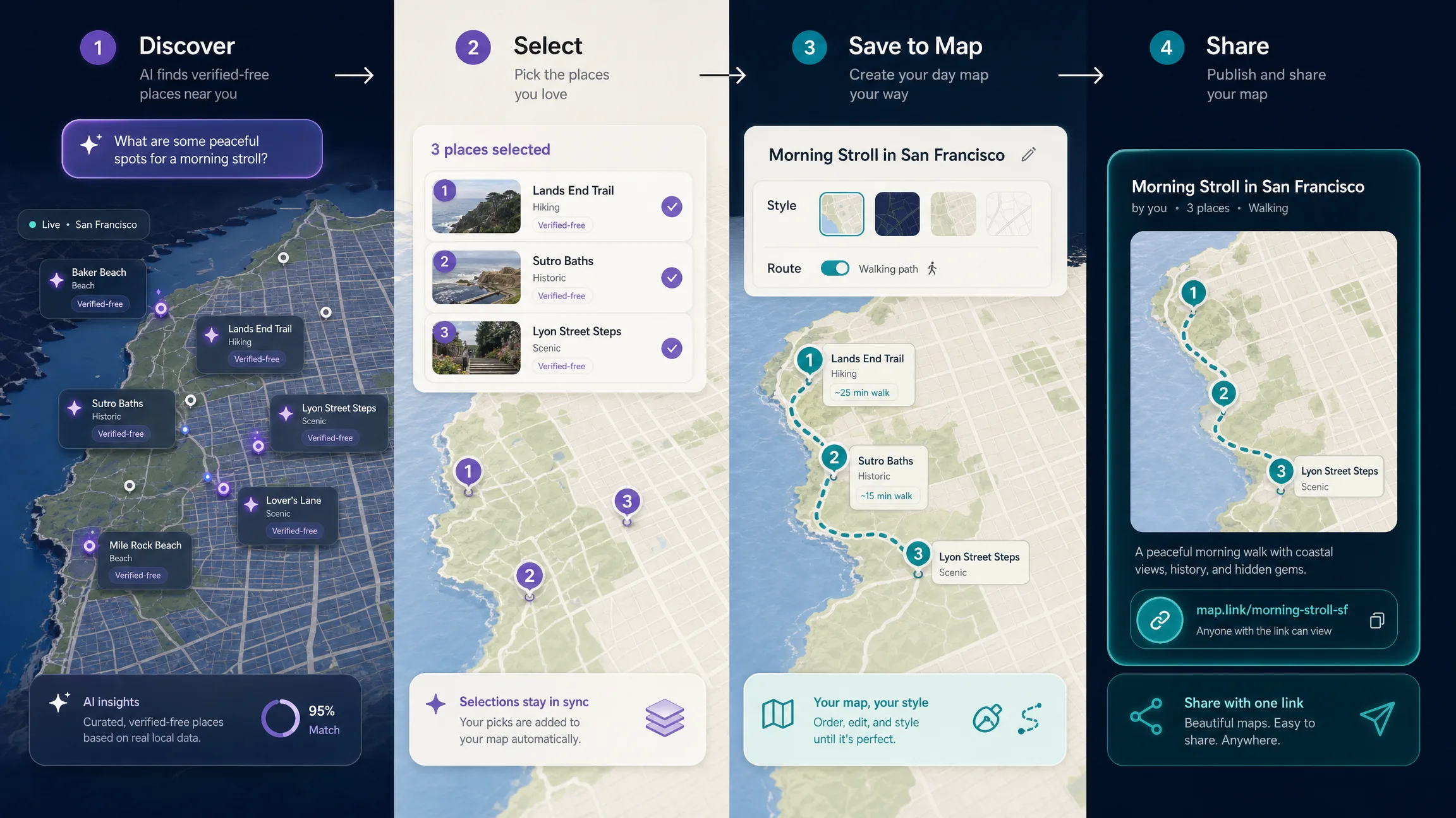
Location is useful data, but it should not be collected casually. Ask for geolocation only when the user requests it, offer typed-location search, avoid storing precise coordinates by default, explain when a location is saved, reduce precision where exact location is unnecessary, separate anonymous exploration from account history, protect saved travel and location history, and do not expose a user’s origin in public shared maps unless they intentionally include it. Treat the browser’s current location as context for the query, not automatically as a permanent user profile attribute. Provide text search, keyboard-operable filters, an accessible result list, programmatic place names, travel-time and fee information in text, visible focus, non-color status indicators, clear no-result messages, and an alternative to precise pointer interaction. A map can supplement the list; it should not be the only way to understand the results.
A live location-aware discovery experience should answer the query; an editorial guide should explain methodology, trust, and planning. Prefer one useful discovery surface over hundreds of thin city pages created only to target keyword variations unless each page contains genuinely useful, current, location-specific results. For answer engines, use extractable language: a free place to explore near you is a publicly accessible location with no required admission fee for the intended visit, and fee, access, and opening-hour data should be verified separately because the place category alone does not prove that entry is free.
Which Mistakes Should Teams Avoid?
| Mistake | What happens | Recommended correction |
|---|---|---|
| Assuming parks are free | Paid or restricted parks are mislabeled | Verify fee separately from category |
| Treating unknown fee as free | Users receive false promises | Keep an explicit unknown state |
| Ranking only by distance | Inconvenient places outrank reachable ones | Use travel time when the task implies accessibility |
| Ignoring public access | Private or restricted locations appear usable | Evaluate access independently |
| Ignoring opening hours | Closed places appear as immediate options | Preserve current-hours evidence and freshness |
| Showing only popular attractions | Results become repetitive and tourist-heavy | Balance relevance with category diversity |
| Using AI prose as source data | The system invents fee or access claims | Ground on structured authoritative records |
| Requiring geolocation | Privacy-conscious users cannot search | Support typed and map-selected origins |
| Hiding everything in the canvas | Accessibility and SEO suffer | Maintain an equivalent result list |
| Tracking only search volume | Traffic is mistaken for useful discovery | Measure selection, save, sharing, and return |
Before release, make the search origin visible and editable, keep current location optional, make radius or travel time explicit, normalize the category taxonomy, attach fee status to an explicit source, keep unknown fee unknown, represent conditional-free rules, check public access separately, preserve opening status and freshness, resolve duplicates, avoid conflating distance and travel time, explain ranking reasons, prevent AI from inventing place facts, provide an accessible list and useful no-result states, document location privacy, offer save and share actions, and measure useful result selection rather than search submissions alone.
Final Verdict
The best way to find free places to explore near you is not to search for a single universal “free attraction” category. Start with a location, search across useful place categories, verify whether admission is actually free, check public access and hours, and rank the eligible results by the way you intend to travel and explore. AI can make that process easier by interpreting requests such as free historic places within a walking window this afternoon, but the AI layer should remain grounded in current place, access, fee, and routing data.
For Kaleidr, this search cluster is especially useful because it connects discovery to creation: find a place, save it, build a map, and share the experience. That path creates more durable value than a static list of generic nearby attractions.
Explore Free Places With Kaleidr Spatial AI
Ask Kaleidr for places that fit your location, context, and interests, then continue refining through natural-language questions. Explore Kaleidr Spatial AI to try free-style local discovery, then move selected finds into a saved map with Kaleidr Studio when you want a durable day plan you can share.
FAQs
How do I find free places to explore near me?
Start with a live map or local-discovery tool, choose useful place categories, and verify fee, access, and opening-hour information. Do not assume a park, museum, beach, or attraction is free solely because of its category.
What kinds of places are usually worth checking?
Parks, trails, public art, viewpoints, libraries, public squares, historic districts, waterfronts, community spaces, and some museums or galleries are useful categories to investigate. Their actual access and fee rules still need verification.
Are all public parks free?
No. Some parks or recreation areas charge entrance, vehicle, reservation, facility, or activity fees. Verify the specific place rather than inferring price from the category.
Are museums shown as free automatically?
They should not be. A museum may be paid, permanently free, free only during certain periods, or free for specific visitors. A discovery product should model those states separately.
What is the difference between nearby and reachable?
Nearby usually measures geographic distance. Reachable considers the route and travel time. A place can be physically close while requiring a longer trip because of roads, rivers, barriers, or transit connections.
Should I let a website use my current location?
Only when you are comfortable doing so. A good discovery product should also let you type a city, neighborhood, or address instead of requiring precise browser geolocation.
How can AI improve local discovery?
AI can interpret multi-variable requests such as free indoor places within twenty minutes that are open this evening. The factual place, access, fee, and routing data should still come from authoritative or approved sources.
Can I save free places into a travel map?
Yes. A useful discovery workflow can let you save selected places, group them into a map, order them into an itinerary, personalize the map, and share it.
Why does a map sometimes show a place as open or free when it is not?
Place information changes and third-party datasets can be incomplete or stale. Products should preserve sources and freshness, and users should verify important access details with the venue or responsible authority before traveling.
References
- Google. Nearby Search (New) — Places API. Google Maps Platform documentation. Accessed 11 August 2026. https://developers.google.com/maps/documentation/places/web-service/nearby-search
- Kaleidr. AI Maps You Can Talk To — Spatial AI. kaleidr.com. Accessed 11 August 2026. https://kaleidr.com/ai
- Kaleidr. Create Custom Maps with AI Map Maker. kaleidr.com. Accessed 11 August 2026. https://kaleidr.com/studio
- OpenStreetMap Wiki. Key:access. Accessed 11 August 2026. https://wiki.openstreetmap.org/wiki/Key:access
- OpenStreetMap Wiki. Key:fee. Accessed 11 August 2026. https://wiki.openstreetmap.org/wiki/Key:fee
- OpenStreetMap Wiki. Key:fee:conditional. Accessed 11 August 2026. https://wiki.openstreetmap.org/wiki/Key:fee:conditional
- OpenStreetMap Wiki. Key:opening_hours. Accessed 11 August 2026. https://wiki.openstreetmap.org/wiki/Key:opening_hours
- OpenStreetMap Wiki. Key:tourism. Accessed 11 August 2026. https://wiki.openstreetmap.org/wiki/Key:tourism
@misc{google_nearby_search,
  title  = {Nearby Search (New) -- Places API},
  author = {{Google}},
  note   = {Google Maps Platform documentation; accessed 11 August 2026},
  url    = {https://developers.google.com/maps/documentation/places/web-service/nearby-search}
}

@misc{kaleidr_spatial_ai,
  title  = {AI Maps You Can Talk To -- Spatial AI},
  author = {{Kaleidr}},
  note   = {Accessed 11 August 2026},
  url    = {https://kaleidr.com/ai}
}

@misc{osm_tourism,
  title  = {Key:tourism},
  author = {{OpenStreetMap Wiki}},
  note   = {Accessed 11 August 2026},
  url    = {https://wiki.openstreetmap.org/wiki/Key:tourism}
}

@misc{osm_access,
  title  = {Key:access},
  author = {{OpenStreetMap Wiki}},
  note   = {Accessed 11 August 2026},
  url    = {https://wiki.openstreetmap.org/wiki/Key:access}
}

@misc{osm_fee,
  title  = {Key:fee},
  author = {{OpenStreetMap Wiki}},
  note   = {Accessed 11 August 2026},
  url    = {https://wiki.openstreetmap.org/wiki/Key:fee}
}

@misc{osm_opening_hours,
  title  = {Key:opening_hours},
  author = {{OpenStreetMap Wiki}},
  note   = {Accessed 11 August 2026},
  url    = {https://wiki.openstreetmap.org/wiki/Key:opening_hours}
}