
A nearby places map turns a user location or chosen reference point into structured local discovery. Reliable implementations ask for location only when needed, retrieve approved place data, apply category and geographic constraints, rank by distance or travel time, handle ambiguity and no-result states, and keep the map synchronized with the result list. AI can make near-me search more expressive, but the model should interpret intent rather than invent places, hours, routes, or business facts.
The sections below cover reference location, place retrieval, distance versus travel time, ranking, grounded AI, privacy, and production checks. Related product context lives on Kaleidr Spatial AI and the chat attachment documentation. For category context and amenity taxonomies, see local amenities mapping and local business discovery.
Near-me essentials
- Explicit origin: Device location, typed place, map point, or visible map area—never a hidden default.
- Approved places: Resolve businesses and amenities from a current place source, not model memory.
- Right “near”: Separate straight-line distance, travel time, and map-bounds search.
- Map + list: Keep markers and result cards on one shared search state.
- Grounded AI: Convert natural language into structured constraints; block invented place facts.
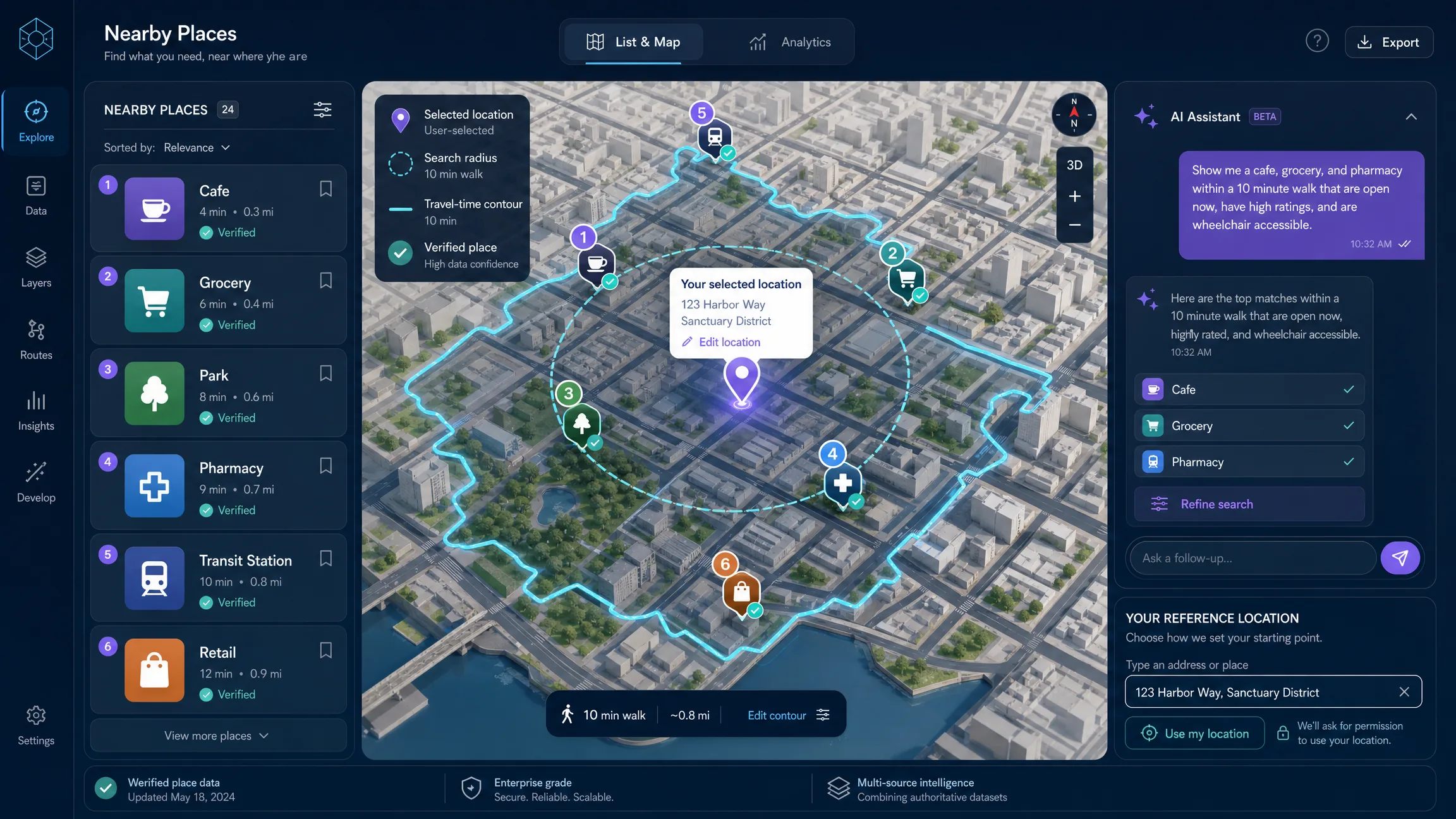
What Will a Nearby Places Map Include?
The finished experience has five coordinated parts: a user-selected or permission-based reference location, an interactive map, nearby place results, category or radius or travel-time controls, and optional AI chat for multi-variable local questions. A user might begin with “coffee near me,” then refine to quiet cafes within a fifteen-minute walk that are open now and close to a bookstore. The first query can use ordinary nearby search; the second combines category, travel mode, time, and another geographic relationship, which is where an AI interaction layer can translate natural language into structured constraints.
Kaleidr currently positions Spatial AI around contextual place discovery and map-aware recommendations, while Kaleidr Chat can attach to an existing Mapbox, Google Maps, MapLibre, or Leaflet map and plot resolved places as the conversation progresses. See Kaleidr Spatial AI and the deeper AI chat on Mapbox, Google Maps, and MapLibre guide when the host already owns the renderer.
Why Is “Near Me” a Geographic Query?
The phrase “near me” hides several decisions: near which point, how that point was obtained, what distance is acceptable, whether “near” means straight-line distance, walking time, driving time, or current map bounds, which categories qualify, which places are open or otherwise eligible, which source is authoritative for each fact, and how matching places should be ranked. A weak implementation treats “near me” as a text string. A stronger implementation turns it into explicit spatial state owned by the host application even when AI can modify parts of the search.
const nearbySearchState = {
  origin: {
    lat: 38.8977,
    lng: -77.0365,
    source: "user_selected"
  },
  categories: ["cafe"],
  radiusMeters: 1500,
  travelMode: "walking",
  openNow: false,
  mapBounds: null,
  selectedPlaceId: null
};
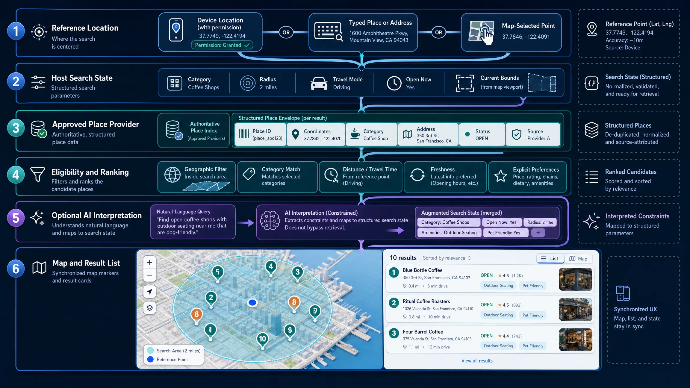
How Should Teams Choose the Reference Location?
A nearby search can start from four common reference points. Device location fits when the user explicitly wants results around their current position and accepts permission and privacy handling. A typed place or address fits when the user will not share device location or is planning elsewhere and requires geocoding or place resolution. A selected map point fits visual exploration and must clearly show the selected origin. Current map extent fits “search this area” workflows, and results should not silently shift during map movement. Do not request device location immediately just because a map is present; ask when the feature needs it and provide a typed-location alternative.
| Reference point | Appropriate when | Main consideration |
|---|---|---|
| Device location | The user wants results around the current position | Requires permission and privacy handling |
| Typed place or address | The user will not share device location or is planning elsewhere | Requires geocoding or place resolution |
| Selected map point | The user explores visually | Must clearly show the selected origin |
| Current map extent | The user wants to search the visible area | Results should not silently shift during map movement |
The browser Geolocation API requires a secure context and user permission. getCurrentPosition() returns the device position when permission is granted, but an implementation must also handle denial, timeout, or unavailable positioning. Device location is an input to the search, not proof of identity or a permanent user attribute. Prefer an explicit “Use my location” control, a status region for loading and failure, and a typed-location fallback when geolocation is unavailable.
How Do You Retrieve and Normalize Nearby Places?
After resolving an origin, the application needs a place source that can return a stable place identifier, name, coordinates, category or type, address, business or operational status when supported, opening information when permitted and current, source-specific attribution, and enough metadata to deduplicate and display the result correctly. Google Places Nearby Search currently accepts one or more place types and a circular location restriction; a response field mask is required and determines which fields are returned, and results can be ranked by popularity or distance (Nearby Search; Place Types). Adapt the request to the provider and commercial terms used by the application, request only the fields the product needs, and keep server credentials on the server.
curl -X POST \
  -H "Content-Type: application/json" \
  -H "X-Goog-Api-Key: YOUR_GOOGLE_PLACES_KEY" \
  -H "X-Goog-FieldMask: places.id,places.displayName,places.location,places.formattedAddress,places.primaryType" \
  -d '{
    "includedTypes": ["cafe"],
    "maxResultCount": 10,
    "locationRestriction": {
      "circle": {
        "center": { "latitude": 38.8977, "longitude": -77.0365 },
        "radius": 1500.0
      }
    },
    "rankPreference": "DISTANCE"
  }' \
  https://places.googleapis.com/v1/places:searchNearby
OpenStreetMap can support another style of nearby discovery when its data and licensing fit the product. The Overpass API is a read-only query service for selecting OpenStreetMap data by location, tags, proximity, and other criteria (Overpass QL). Public Overpass instances are shared infrastructure and are not a universal production backend; teams with high-volume or latency-sensitive workloads should review usage expectations, data update patterns, hosting options, attribution, and the OpenStreetMap license before adopting an architecture. Normalize provider results into the application’s own place model instead of letting provider-specific fields leak everywhere in the UI. Keep source ownership explicit: a provider place ID, an internal business ID, and an OpenStreetMap object ID are different identities even when they describe the same real-world place.
{
  "place_id": "provider:abc123",
  "source": "approved_place_provider",
  "name": "Example Cafe",
  "location": {
    "type": "Point",
    "coordinates": [-77.0365, 38.8977]
  },
  "categories": ["cafe", "coffee"],
  "address": "Example address",
  "business_status": "OPEN",
  "retrieved_at": "2026-08-09T17:00:00Z"
}
How Do Distance and Travel Time Differ?
Straight-line distance is useful for an initial radius query, but users often experience “near” in minutes. Two places a similar geometric distance away can have very different walking or driving times because of highways, rivers, rail lines, private property, pedestrian crossings, street direction, building entrances, and transit schedules. A robust product can retrieve candidate places inside a broad geographic radius, then calculate travel time only for the short candidate set when the user’s task requires it. This controls cost and latency while keeping the result useful. Use language such as “1.2 km away” when displaying geometric or provider distance, “12 min walk” when using a routing service, and “within the selected area” when the query is polygon-based. Do not convert a straight-line radius into a claim about walking time.
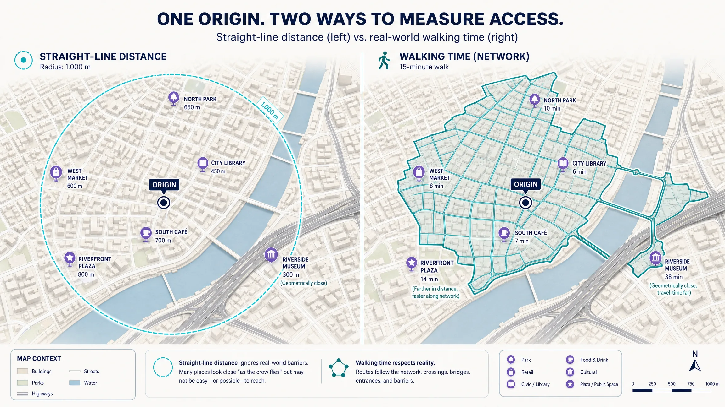
How Should Results Be Ranked and Shown on the Map?
The nearest place is not always the most relevant place. A local-discovery ranking system may consider hard category match, geographic eligibility, distance, travel time, current availability, user-selected attributes, source freshness, place confidence, and product-specific business rules. Apply hard constraints before scoring preferences: eligible geography, required category, required availability, distance or travel-time score, explicit user preferences, freshness and confidence, then final ranking. Do not quietly use sensitive personal attributes or hidden demographic proxies to rank local results. When the assistant explains why a result appears, prefer machine-readable reasons such as category match, walking threshold, and open-during-requested-period rather than an opaque score.
Nearby search should never be map-only. Every visible place should also be available in a navigable result list, and the map and list should share one state. New searches should fit the approved result geography and replace the list; selecting a card should highlight the corresponding marker; selecting a marker should focus the matching card; category or origin changes should recalculate both surfaces; clearing search should remove transient layers and restore the default state. Avoid fetching on every animation frame. Use an explicit “Search this area” action or a debounced provider idle event if map movement changes the query.
| User action | Map | Result list |
|---|---|---|
| New search | Fit the approved result geography | Replace results and update count |
| Select card | Highlight corresponding marker | Keep selected card visible |
| Select marker | Highlight place | Focus or reveal matching card |
| Change category | Recalculate visible places | Recalculate list |
| Change origin | Move origin marker and search area | Refresh eligible results |
| Clear search | Remove transient search layers | Restore default state |
How Can AI Improve Multi-Variable Nearby Questions?
Conventional nearby search works well for deterministic requests such as grocery stores within two kilometers, pharmacies open now, EV chargers near a hotel, or parks in the current map area. AI becomes useful when the request contains multiple flexible conditions—quiet cafes near a bookstore, free rainy-afternoon activities nearby, stores near transit and still open after eight, or a restaurant halfway between two locations. The AI layer should convert the request into explicit spatial and place constraints. Kaleidr Chat currently mounts over a live map and can plot resolved places and frame the map as a conversation resolves locations. Load the versioned loader from https://cdn.kaleidr.com/embed/v1/kaleidr.js, then mount chat against the host map with a publishable key that includes the ai scope. The current documentation states that the SDK exchanges the browser publishable key for a short-lived, origin-bound session; keep server keys on the backend (auth and scopes).
const chat = Kaleidr.mount("#chat", {
  product: "chat",
  publishableKey: "kld_pk_live_REPLACE_ME",
  map: myMap
});
How Should Teams Ground AI and Protect Location Privacy?
AI should not answer “near me” questions from model memory when the application has a current place source. Use this sequence: user intent, explicit geographic origin, approved place retrieval, eligibility and ranking, AI explanation, then visible map and list result. Prevent invented businesses, closed places presented as open, duplicate listings, same-name businesses in the wrong city, stale addresses, unsupported accessibility claims, estimated travel times presented as exact, and results outside the selected search boundary. When a user asks a question the data cannot support, say so rather than filling the gap with plausible text.
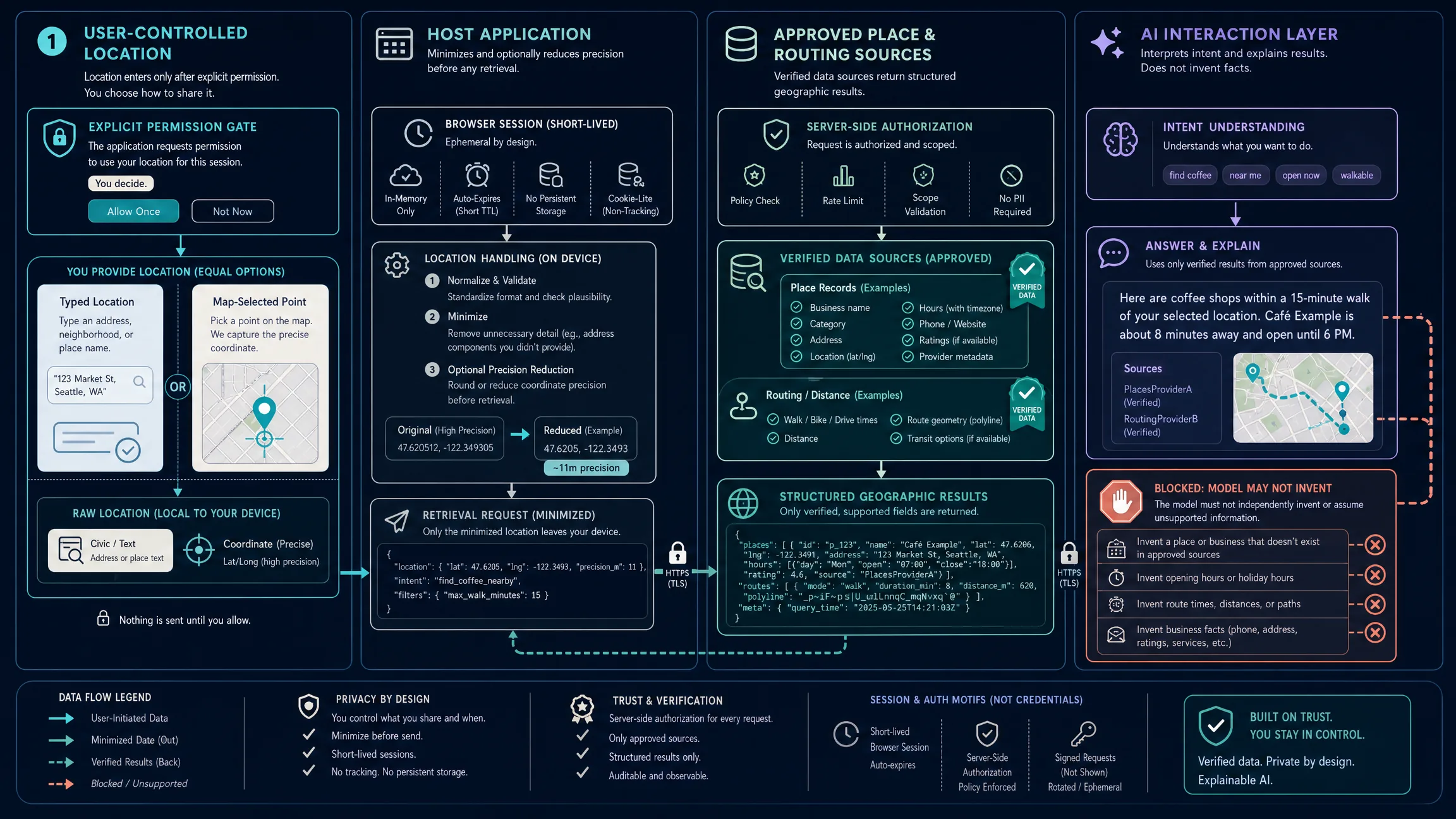
Current location is sensitive product context. A responsible nearby search should request geolocation only after a user action or clear need, explain why location improves the result, provide a typed-location alternative, avoid storing precise location longer than necessary, reduce precision when exact coordinates are not required, separate location history from account identity unless the feature requires both, disclose retention and sharing, prevent third-party embeds from receiving location accidentally, and respect browser and application permission boundaries. If a map is embedded in an iframe, browser Permissions-Policy geolocation may also affect access; test the real deployment origin rather than assuming a local prototype’s behavior will match production.
A nearby-place experience should remain usable without dragging a map or visually locating pins. Provide a text location input, accessible category controls, a complete result list, keyboard-operable cards, visible focus, text equivalents for selected-marker state, non-color indicators, clear loading and empty and error messages, an accessible route or directions action, an alternative to map-based area selection, and sufficient target size on mobile. The list should carry the core information even if the map fails to render. Public landing pages should still explain place types, coverage, data sources, distance or travel-time methods, freshness, and typed-location alternatives in crawlable text, and should not mass-generate thin city pages from one template.
Which Mistakes Should Teams Avoid?
| Mistake | What happens | Recommended correction |
|---|---|---|
| Requesting location on page load | Users deny permission before understanding the value | Ask after an explicit action and offer typed search |
| Treating “near” as one universal radius | Results feel arbitrary | Expose distance, travel time, or map-area logic |
| Returning every place in a radius | The map becomes cluttered and relevance drops | Filter and rank before rendering |
| Trusting AI-generated place facts | Plausible but incorrect places or hours appear | Ground answers in an approved place source |
| Using only markers | Keyboard and screen-reader users lose the result set | Maintain an equivalent synchronized list |
| Re-querying on every map movement | Costs and visual instability increase | Debounce or use “Search this area” |
| Mixing provider IDs | Duplicates and broken detail pages appear | Normalize place identity and retain source IDs |
| Treating straight-line distance as travel time | Users receive misleading proximity claims | Use routing when the query is time-based |
| Persisting exact user coordinates by default | Privacy risk grows without product value | Minimize retention and precision |
| Tracking map views instead of outcomes | Traffic is confused with utility | Measure result selection, routes, saves, and conversion |
Before release, define the nearby-search use case and reference-location options, request geolocation only when needed, implement typed-location fallback, select an approved place source, normalize the place schema, retain stable source IDs, document category taxonomy, separate distance and travel-time semantics, document ranking reasons, synchronize map and list, convert AI requests to explicit constraints, preserve grounding sources, exclude server credentials from browser code, implement empty and ambiguous states, and test accessibility, privacy retention, and real queries across dense and sparse geographies. Measure successful search rate, no-result rate, geolocation acceptance, typed-location fallback success, result selection, route requests, saves, shares, AI completion when used, time to first useful result, and downstream conversion after a place selection rather than raw map pans.
Final Verdict
A useful nearby places map is not simply a pin map centered on the user’s GPS coordinates. The product is a search system with a geographic origin, explicit place categories, authoritative records, a ranking model, map-and-list synchronization, privacy controls, and measurable outcomes. Use conventional nearby search for simple deterministic requests. Add AI when users need to express context that is difficult to capture with fixed filters. Keep the AI grounded in the current place source, make distance and travel-time semantics visible, and never require device geolocation when a typed location can accomplish the same task.
For Kaleidr, the product pattern is straightforward: the existing renderer and host application can continue to own the map and workflow, while Kaleidr Chat adds map-aware natural-language interaction and Spatial AI helps users explore places with more context.
Explore Nearby Places With Kaleidr Spatial AI
Ask location questions, discover places, and explore results on an interactive map. Try Kaleidr Spatial AI to exercise near-me style discovery, then attach Kaleidr Chat to the Mapbox, Google Maps, or MapLibre map your product already runs when the host owns renderer and search state.
FAQs
What is a nearby places map?
A nearby places map shows businesses, amenities, services, attractions, or other geographic features around a reference location. A complete implementation combines place retrieval, geographic filtering, ranking, a synchronized map and result list, and clear source data.
How does “near me” search work?
The application resolves a reference location, retrieves candidate places inside a geographic area, applies category and eligibility rules, ranks the candidates, and displays the results. Travel-time-based searches may add routing after candidate retrieval.
Does a website need my GPS location for “near me” search?
No. Device geolocation is one option. A website can also let the user enter a city, address, landmark, or selected point on the map.
Should I rank nearby places by distance or popularity?
It depends on the task. Distance fits requests such as “closest pharmacy.” Popularity can help general discovery. Multi-variable searches often require eligibility rules and a custom ranking model before either signal.
Is a radius the same as travel time?
No. A radius measures geometric distance from a point. Travel time depends on the transportation network, travel mode, barriers, and provider routing data.
Can AI find places near me?
Yes, but AI should interpret the user’s request and coordinate structured retrieval. The actual place records should come from an approved, current place source rather than model memory.
Can I use OpenStreetMap for nearby search?
OpenStreetMap data can support nearby feature search, and Overpass API can query OSM data by tags and proximity. Production use requires appropriate architecture, attribution, licensing review, and capacity planning.
How does Kaleidr fit into nearby search?
Kaleidr can add a map-aware conversational layer to an existing supported map. The host application can keep its provider, search state, permissions, and business systems while Kaleidr Chat plots resolved places and supports natural-language exploration.
References
- Google. Nearby Search (New) — Places API. Google Maps Platform documentation. Accessed 9 August 2026. https://developers.google.com/maps/documentation/places/web-service/nearby-search
- Google. Place Types (New) — Places API. Google Maps Platform documentation. Accessed 9 August 2026. https://developers.google.com/maps/documentation/places/web-service/place-types
- Kaleidr. AI Maps You Can Talk To — Spatial AI. kaleidr.com. Accessed 9 August 2026. https://kaleidr.com/ai
- Kaleidr. Introduction. Kaleidr Developer Docs. Accessed 9 August 2026. https://docs.kaleidr.com/
- Kaleidr. Chat — attach AI to your map. Kaleidr Developer Docs. Accessed 9 August 2026. https://docs.kaleidr.com/sdk/chat-attach
- Kaleidr. Auth & scopes. Kaleidr Developer Docs. Accessed 9 August 2026. https://docs.kaleidr.com/platform-api/auth-and-scopes
- MDN Web Docs. Geolocation API. Accessed 9 August 2026. https://developer.mozilla.org/en-US/docs/Web/API/Geolocation_API
- MDN Web Docs. Geolocation: getCurrentPosition() method. Accessed 9 August 2026. https://developer.mozilla.org/en-US/docs/Web/API/Geolocation/getCurrentPosition
- MDN Web Docs. Permissions-Policy: geolocation directive. Accessed 9 August 2026. https://developer.mozilla.org/en-US/docs/Web/HTTP/Reference/Headers/Permissions-Policy/geolocation
- OpenStreetMap Wiki. Overpass API. Accessed 9 August 2026. https://wiki.openstreetmap.org/wiki/Overpass_API
- OpenStreetMap Wiki. Overpass QL. Accessed 9 August 2026. https://wiki.openstreetmap.org/wiki/Overpass_API/Overpass_QL
@misc{google_nearby_search,
  title  = {Nearby Search (New) -- Places API},
  author = {{Google}},
  note   = {Google Maps Platform documentation; accessed 9 August 2026},
  url    = {https://developers.google.com/maps/documentation/places/web-service/nearby-search}
}

@misc{kaleidr_chat_attach,
  title  = {Chat -- attach AI to your map},
  author = {{Kaleidr}},
  note   = {Kaleidr Developer Docs; accessed 9 August 2026},
  url    = {https://docs.kaleidr.com/sdk/chat-attach}
}

@misc{kaleidr_spatial_ai,
  title  = {AI Maps You Can Talk To -- Spatial AI},
  author = {{Kaleidr}},
  note   = {Accessed 9 August 2026},
  url    = {https://kaleidr.com/ai}
}

@misc{mdn_geolocation,
  title  = {Geolocation API},
  author = {{MDN Web Docs}},
  note   = {Accessed 9 August 2026},
  url    = {https://developer.mozilla.org/en-US/docs/Web/API/Geolocation_API}
}

@misc{osm_overpass,
  title  = {Overpass API},
  author = {{OpenStreetMap Wiki}},
  note   = {Accessed 9 August 2026},
  url    = {https://wiki.openstreetmap.org/wiki/Overpass_API}
}

@misc{google_place_types,
  title  = {Place Types (New) -- Places API},
  author = {{Google}},
  note   = {Accessed 9 August 2026},
  url    = {https://developers.google.com/maps/documentation/places/web-service/place-types}
}