
To plot places on a map, turn every location into a reliable geographic record before you render markers. Validate latitude and longitude when you already have coordinates. Geocode addresses and resolve place names when you do not. Store stable IDs, categories, and source metadata in one structure, then render points with a visual map builder or a mapping library. Most accuracy problems begin with ambiguous names, reversed coordinate order, duplicate records, or unverified geocoding—not with pin styling.
The sections below cover place records, geocoding, coordinate order, GeoJSON, MapLibre rendering, Studio versus code, AI boundaries, accessibility, and publishing mistakes. Related product context lives on Kaleidr Studio and the developer documentation. For the architecture choice, see No-Code Map Builder vs Map API. For coordinate search detail, see Search Location Using Latitude and Longitude.
Multi-place mapping essentials
- Resolve first: Names and addresses need place resolution or geocoding before plotting.
- Validate coordinates: Range checks catch impossible pairs; review still catches wrong places.
- Longitude first in GeoJSON: Human text is often latitude first; GeoJSON positions reverse that order.
- Deduplicate before render: Shared buildings and dual source IDs create fake density.
- Separate AI from facts: AI can organize structure; verified records own coordinates.
What Does It Mean to Plot Places on a Map?
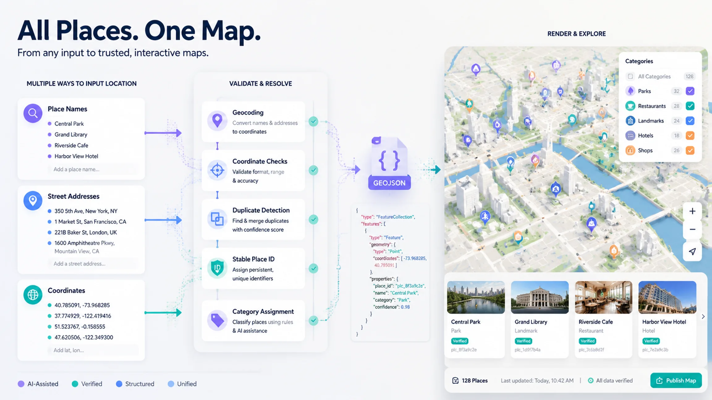
Plotting places means converting a set of locations into geographic points and displaying those points on one shared map. Inputs can include place names, street addresses, latitude and longitude, CRM or store records, travel destinations, venues, listings, facilities, or an existing GeoJSON dataset. Outputs usually include one point per place, labels or popups, categories, filters, map bounds that include the relevant locations, and optional links or actions. The decisive question before styling is whether each record already has reliable coordinates. Direct mapping is possible when coordinates are trustworthy; otherwise the pipeline needs geocoding or place resolution first.
| Input | Required step | Best when |
|---|---|---|
| Place names | Resolve each name to a specific place | Users know landmarks or businesses |
| Addresses | Geocode each address | Data comes from CRM, store, or operations |
| Latitude + longitude | Validate and map directly | Coordinates already come from GPS or a spatial system |
How Should You Structure Each Place Record?
Define a stable record before placing markers. Useful fields include a durable ID, human-readable name, address when relevant, latitude, longitude, category, status, source, last-updated timestamp, and an optional detail URL. Stable IDs matter because names and addresses change, venues rebrand, and similar names can refer to different businesses. Identify a place by its durable record ID rather than by display label alone.
{
  "id": "store_001",
  "name": "Example Bookshop",
  "address": "123 Example Street, Boston, MA",
  "latitude": 42.3601,
  "longitude": -71.0589,
  "category": "bookstore",
  "status": "active",
  "url": "https://example.com/store_001"
}
How Do Addresses and Coordinates Become Map Points?
Geocoding converts an address into geographic coordinates. Google’s Geocoding API accepts an address and returns latitude, longitude, and a Place ID, and it also supports reverse geocoding from coordinates back to a readable address (Geocoding API overview). A geocoder can return more than one plausible match, so do not accept every first result blindly. Ambiguity often comes from missing city or country, reused street names, incomplete postal codes, multi-branch business names, new developments, or informal labels. Keep the original input beside the resolved name, formatted address, coordinates, source, and resolution status. Send uncertain high-value matches to review rather than forcing a coordinate.
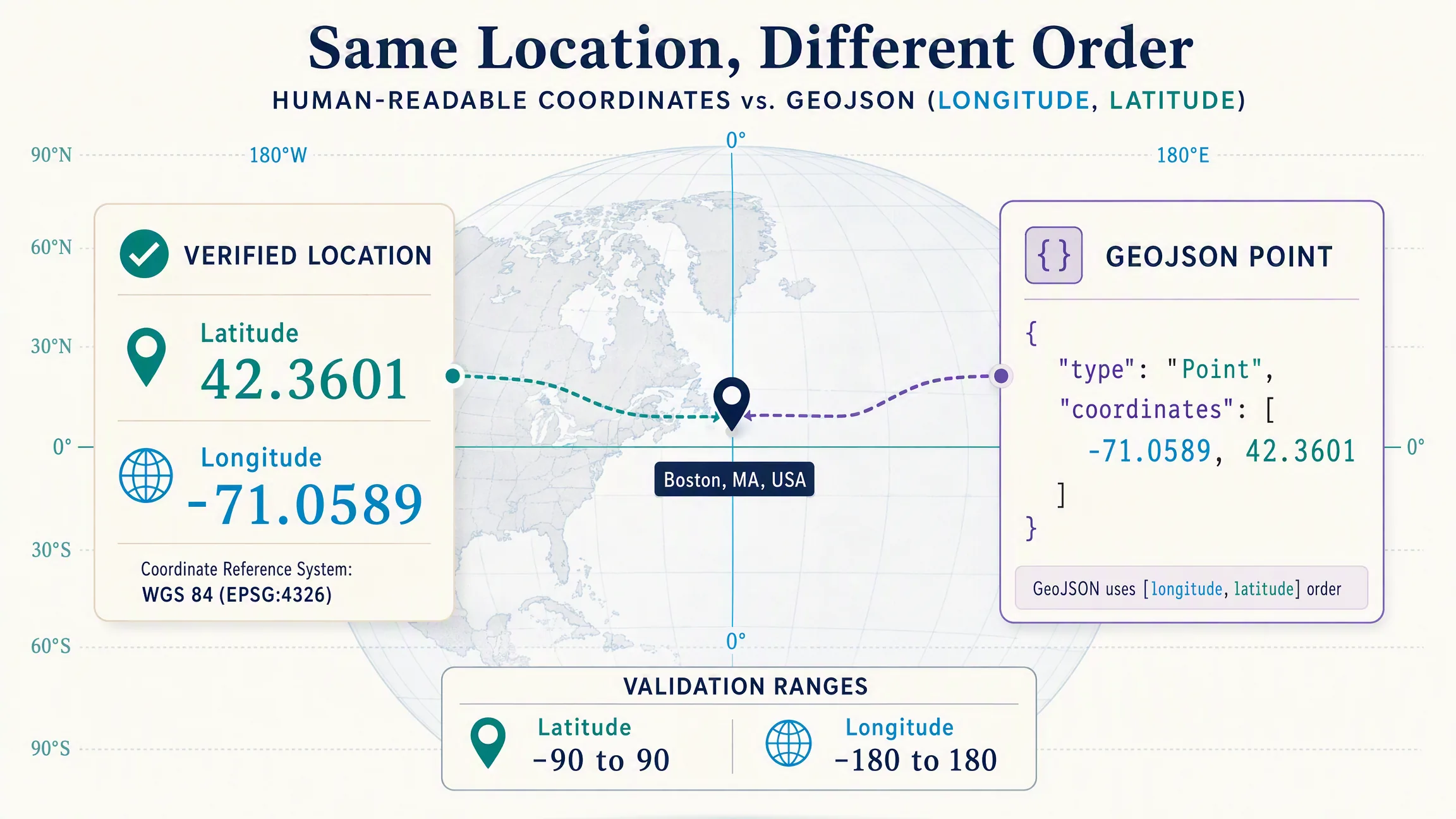
When coordinates already exist, validate mathematical possibility first. WGS 84 latitude runs from -90 to 90 and longitude from -180 to 180. A finite pair inside those ranges is possible, not proven. Wrong points still appear when latitude and longitude are reversed, a minus sign is dropped, another coordinate reference system is used, the source is stale, a centroid replaces an entrance, or the values were copied from the wrong record.
function isValidCoordinate(latitude, longitude) {
  return Number.isFinite(latitude) &&
    Number.isFinite(longitude) &&
    latitude >= -90 &&
    latitude <= 90 &&
    longitude >= -180 &&
    longitude <= 180;
}
Why Does Coordinate Order Matter in GeoJSON?
A human-readable coordinate is often written latitude first, then longitude—for example 42.3601, -71.0589. GeoJSON positions use longitude first and latitude second, so the same place becomes [-71.0589, 42.3601]. RFC 7946 defines that order for GeoJSON positions (RFC 7946). Building a Point with [longitude, latitude] is correct; swapping the pair maps a plausible-looking location to the wrong region.
const latitude = 42.3601;
const longitude = -71.0589;

const geojsonPoint = {
  type: "Point",
  coordinates: [longitude, latitude]
};
How Do You Convert Places Into GeoJSON and Render Them?
GeoJSON is a common interchange format for geographic data. A collection of places becomes a FeatureCollection where geometry carries location and properties carry meaning—name, category, status, and links. That separation lets the renderer place points from geometry while labels, colors, filters, and detail panels read properties.
MapLibre GL JS can add a GeoJSON source and draw points with a circle or symbol layer (Draw GeoJSON points, GeoJSONSource). Use a production style URL you are authorized to serve. For many points, one source and layer is usually easier to manage than many independent DOM markers because filters, data-driven styling, clustering, visibility, hover queries, and source replacement stay consistent. DOM markers still help when every point needs rich HTML.
import maplibregl from "maplibre-gl";

const places = {
  type: "FeatureCollection",
  features: [
    {
      type: "Feature",
      properties: { name: "Museum", category: "culture" },
      geometry: { type: "Point", coordinates: [-71.0589, 42.3601] }
    },
    {
      type: "Feature",
      properties: { name: "Park", category: "outdoors" },
      geometry: { type: "Point", coordinates: [-71.0656, 42.3554] }
    }
  ]
};

const map = new maplibregl.Map({
  container: "map",
  style: "https://demotiles.maplibre.org/style.json",
  center: [-71.062, 42.358],
  zoom: 13
});

map.on("load", () => {
  map.addSource("places", { type: "geojson", data: places });
  map.addLayer({
    id: "place-points",
    type: "circle",
    source: "places",
    paint: { "circle-radius": 7, "circle-stroke-width": 2 }
  });
});
Fit the camera to a bounding box of valid points when the product should show the full eligible set, and avoid blind fitting when one outlier dominates, hidden results should not move the camera, the user location should stay centered, or a selected place should remain dominant. Classify places into categories before assigning colors so styling stays a visual encoding of data rather than one-off marker art. For dense datasets, prefer clustering, filters, zoom-dependent visibility, server-side queries, or tiles instead of shipping an entire operational database to the browser.
When Should You Use Studio Versus Custom Code?
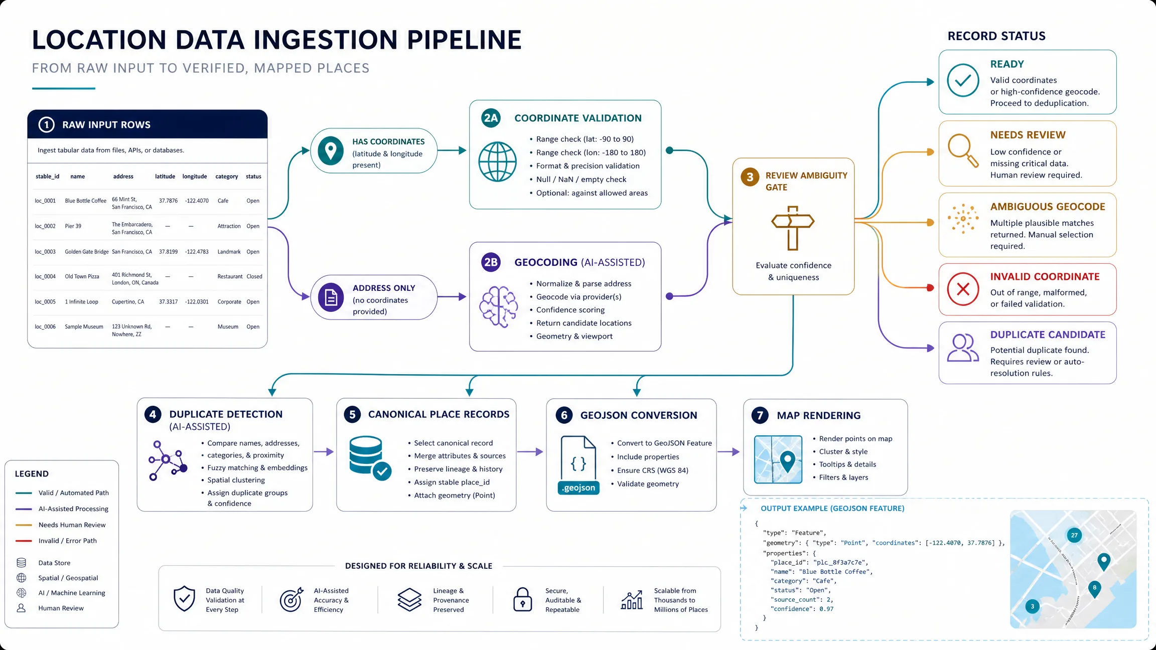
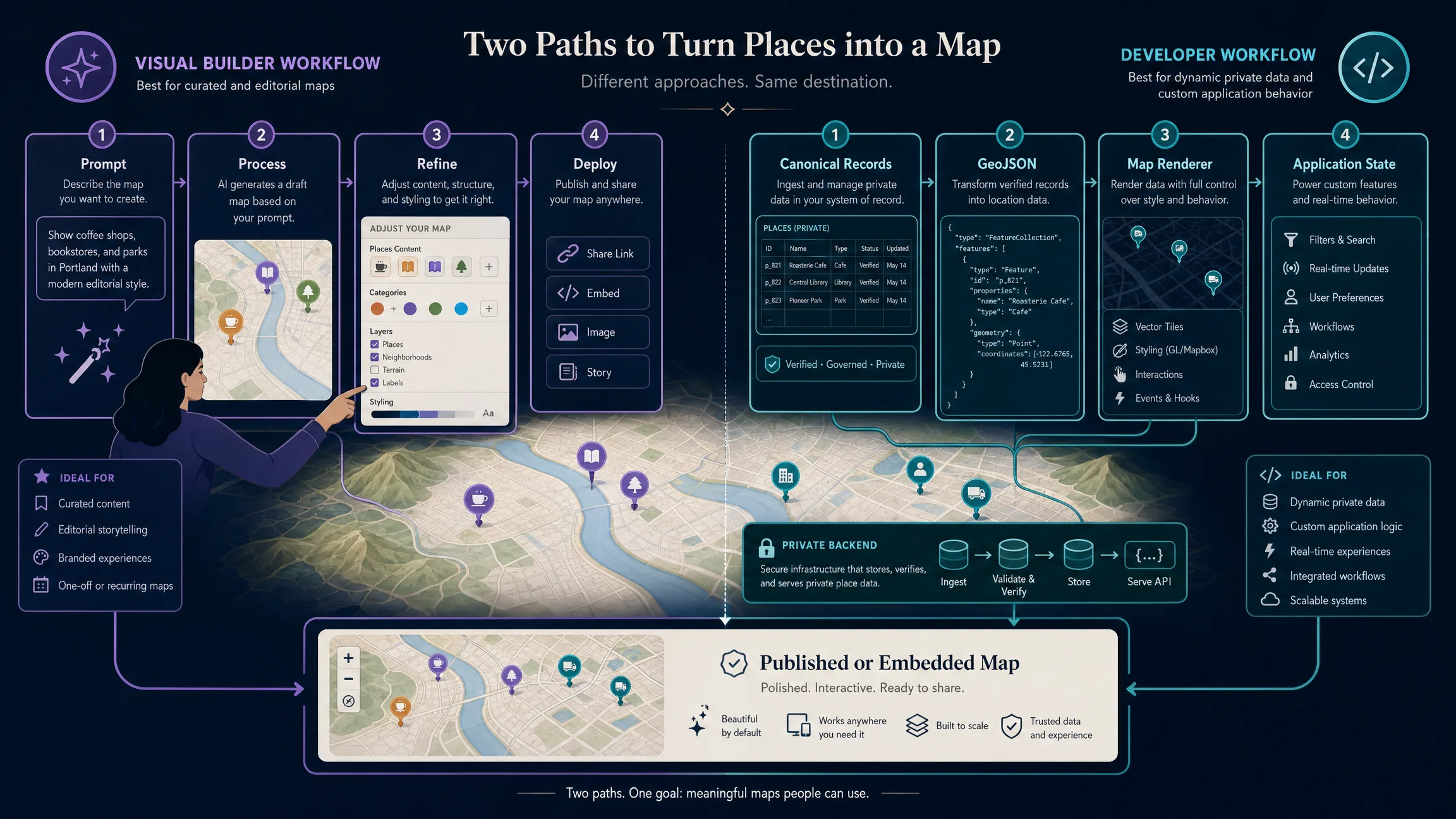
Not every map needs custom JavaScript. Kaleidr Studio describes a prompt-first visual workflow—Prompt, Process, Refine, Deploy—where creators describe a map concept, Spatial AI organizes structure, authors refine design and content, and teams publish a standalone page or embed. A prompt-first path fits curated or editorial maps with manageable datasets and strong visual control. A developer path fits private backends, continuously changing data, permissioned views, custom application state, and large specialized rendering needs. Spreadsheet rows often mix coordinate-ready records with address-only rows; normalize fields, validate coordinates, geocode unresolved addresses, review ambiguity, deduplicate, create canonical records, convert to GeoJSON, then render. Use a standards-compliant CSV parser because quoted fields can contain commas. Confirm the current Studio interface before depending on a specific bulk-import contract.
AI can interpret multi-variable requests and propose categories or an initial structure, but AI should not become the authoritative database for factual coordinates, hours, or operational status. Route candidate places through verified organizational records, a geocoder, an approved place source, explicit coordinates, or a reviewed map edit before publication. Deduplicate using provider place IDs, stable internal IDs, normalized addresses, proximity, and normalized names together—not coordinates alone, because multiple businesses can share a building. Track ingestion states such as ready, needs review, invalid coordinate, ambiguous geocode, duplicate candidate, missing location, and excluded so the map shows the clean eligible set while operators still see failures.
How Do List Sync, Accessibility, and Measurement Fit?
A useful multi-location map often includes a result list that shares one underlying place store with the map layer. Selecting a map point should select the matching list item with the same name and metadata; selecting a list item should highlight the matching point without destroying the user’s context. Keep an equivalent textual list, keyboard-operable filters, accessible place names, visible focus, non-color-only selection, clear categories, and understandable empty or error states. Google’s Advanced Markers documentation notes support for click and keyboard interaction when markers are implemented appropriately (Markers overview). Measure map boot, time to first visible places, filter updates, pan and zoom responsiveness, payload size, successful place-resolution rate, validation failures, duplicates, publish rate, and place selection rather than map loads alone.
Which Mistakes Should Teams Avoid?
| Mistake | Result | Better approach |
|---|---|---|
| Plotting names without resolving identity | Wrong branches or cities | Resolve each place to a stable record |
| Reversing coordinates | Points appear in the wrong region | Validate coordinate order per format |
| Treating a valid range as proof | Plausible but wrong locations pass | Reverse-check or review important records |
| Styling before classification | Marker system becomes inconsistent | Define categories first |
| Rendering every row | Invalid and duplicate records appear | Build an eligibility pipeline |
| Using DOM markers for huge datasets | Performance degrades | Use sources, layers, clustering, or tiles |
| Hiding data only in the map | Accessibility suffers | Maintain a synchronized result list |
| Letting AI invent coordinates | Factual reliability falls | Validate with authoritative spatial data |
| Fitting to every point blindly | Outliers ruin the camera | Apply outlier and visibility rules |
Final Verdict
Plotting multiple places is mainly a data-quality problem followed by a rendering problem. Validate coordinates when they exist, geocode and review addresses or names when they do not, keep canonical records with stable IDs, and only then style markers or publish. For editorial, travel, directory, or lightweight business maps, a prompt-first builder can remove much of the stack work. For dynamic product data, private systems, or large datasets, keep canonical place records in the host application and use a map library or SDK as the rendering layer.
Plot Places on a Map in Kaleidr Studio
Describe the map you want, refine its places and visual structure, and publish the finished interactive experience. Open Kaleidr Studio to start from a prompt, then review the developer documentation when the map needs application-owned state or embedded components.
FAQs
How do I plot places on a map?
Convert each place into a reliable geographic record with latitude and longitude, then render those points with a visual map builder or mapping library. Addresses and place names need geocoding or resolution first.
Can I plot a list of addresses on a map?
Yes. Geocode each address into coordinates, review ambiguous matches, remove duplicates, and render the validated records. Keep the original address alongside the resolved coordinates.
Can I plot latitude and longitude directly?
Yes. Validate that latitude is between -90 and 90 and longitude is between -180 and 180, then use the coordinate order required by your mapping format.
What coordinate order does GeoJSON use?
GeoJSON uses longitude first and latitude second: [longitude, latitude].
What is the best format for multiple map points?
GeoJSON is a common web mapping format because it represents geographic geometry and associated feature properties in one structured object.
Should I use markers or a GeoJSON layer?
Individual markers can work well for small datasets and highly customized HTML interactions. A GeoJSON source and layer are often easier to manage for larger or filterable point sets.
How do I plot places from a CSV file?
Parse the CSV with a proper CSV parser, normalize the columns, validate existing coordinates, geocode unresolved addresses, review failures, and convert the eligible rows into map features.
Can AI plot places automatically?
AI can help interpret a map request, organize categories, or generate an initial structure. Important place identities and coordinates should still be verified with an authoritative location source or reviewed data.
Can Kaleidr Studio create a map without coding?
Yes. Kaleidr’s Studio page describes a prompt-first visual authoring path: describe the map, let Spatial AI generate structure, refine design and content visually, then publish a standalone page or embeddable widget.
When should I build the map with code instead?
Use a developer implementation when locations come from private or frequently changing systems, user-specific permissions matter, datasets are large, or the map participates directly in application workflows.
References
- Google. Geocoding API overview. Google Maps Platform documentation. Accessed 13 August 2026. https://developers.google.com/maps/documentation/geocoding/guides-v3/overview
- Google. Markers overview — Maps JavaScript API. Google Maps Platform documentation. Accessed 13 August 2026. https://developers.google.com/maps/documentation/javascript/advanced-markers/overview
- Internet Engineering Task Force. RFC 7946: The GeoJSON Format. Accessed 13 August 2026. https://datatracker.ietf.org/doc/html/rfc7946
- Kaleidr. Create Custom Maps with AI Map Maker. Accessed 13 August 2026. https://kaleidr.com/studio
- Kaleidr. Build with Kaleidr. Kaleidr Developer Docs. Accessed 13 August 2026. https://docs.kaleidr.com/
- MapLibre. Draw GeoJSON points. MapLibre GL JS documentation. Accessed 13 August 2026. https://maplibre.org/maplibre-gl-js/docs/examples/draw-geojson-points/
- MapLibre. GeoJSONSource. MapLibre GL JS API documentation. Accessed 13 August 2026. https://maplibre.org/maplibre-gl-js/docs/API/classes/GeoJSONSource/
@misc{google_geocoding_overview_2026,
  title  = {Geocoding API overview},
  author = {{Google}},
  note   = {Google Maps Platform documentation; accessed 13 August 2026},
  url    = {https://developers.google.com/maps/documentation/geocoding/guides-v3/overview}
}

@misc{google_markers_overview_2026,
  title  = {Markers overview -- Maps JavaScript API},
  author = {{Google}},
  note   = {Google Maps Platform documentation; accessed 13 August 2026},
  url    = {https://developers.google.com/maps/documentation/javascript/advanced-markers/overview}
}

@misc{rfc7946,
  title  = {RFC 7946: The GeoJSON Format},
  author = {Butler, Howard and Daly, Martin and Doyle, Allan and Gillies, Sean and Hagen, Stefan and Schaub, Tim},
  year   = {2016},
  publisher = {Internet Engineering Task Force},
  url    = {https://datatracker.ietf.org/doc/html/rfc7946}
}

@misc{kaleidr_studio_2026,
  title  = {Create Custom Maps with AI Map Maker},
  author = {{Kaleidr}},
  note   = {Accessed 13 August 2026},
  url    = {https://kaleidr.com/studio}
}

@misc{kaleidr_developer_2026,
  title  = {Build with Kaleidr},
  author = {{Kaleidr}},
  note   = {Kaleidr Developer Docs; accessed 13 August 2026},
  url    = {https://docs.kaleidr.com/}
}

@misc{maplibre_geojson_points,
  title  = {Draw GeoJSON points},
  author = {{MapLibre}},
  note   = {MapLibre GL JS documentation; accessed 13 August 2026},
  url    = {https://maplibre.org/maplibre-gl-js/docs/examples/draw-geojson-points/}
}

@misc{maplibre_geojson_source,
  title  = {GeoJSONSource},
  author = {{MapLibre}},
  note   = {MapLibre GL JS API documentation; accessed 13 August 2026},
  url    = {https://maplibre.org/maplibre-gl-js/docs/API/classes/GeoJSONSource/}
}