
An interactive visited countries map lets a traveler select countries on a world map, mark them as visited or planned, save that state, and return later. Unlike a travel map with city pins, the primary geometry is the country boundary: each country is a polygon or multipolygon joined to a stable identifier and user status. A strong build also defines what counts as a country, documents the boundary source, keeps tiny countries selectable, and separates travel data from map styling.
The sections below cover data architecture, country identifiers, boundary policy, MapLibre rendering, persistence, accessibility, privacy, Studio handoff, and common mistakes. Related product context lives on Kaleidr Studio. For pin-based place maps, see How to Create a Travel World Map With Pins. For plotting many places, see Plot Places on a Map.
Visited-countries essentials
- Polygons, not pins: Country tracking uses boundaries; city memories use points.
- Separate datasets: Shared geometry joins personalized travel state by stable ID.
- Counting is policy: Eligible-country denominators are product rules, not feature counts.
- State before style: Store
visited/want_to_visit, then choose colors.- Handoff carefully: A lightweight tracker can lead into richer Studio maps without overclaiming features.
What Is an Interactive Visited Countries Map?
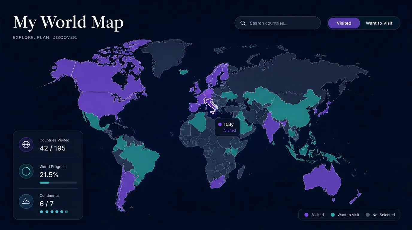
A visited-countries map is a world map whose countries behave like interactive geographic objects rather than a static background. Users typically select a country, mark it visited or wish-listed, search by name, see a running count or percentage, save progress, and share a high-level summary. The core model is country geometry plus a stable country ID plus user travel status. Product decisions around that model matter: country boundaries are politically sensitive, totals depend on counting policy, and detailed future travel history can be private.
| Experience | Primary geometry | Best for |
|---|---|---|
| Visited countries map | Country polygons | Country tracking, world progress, bucket lists |
| Travel map with pins | Points | Cities, landmarks, hotels, restaurants, memories |
| Route map | Lines + points | Road trips, itineraries, journeys |
| Travel journal map | Points + content | Notes, photos, dates, stories |
A country tracker answers which countries a traveler has visited. A pin map answers which specific places they have visited. A good travel product can support both without forcing them into one overloaded map.
How Should Country Geometry and Travel State Be Stored?
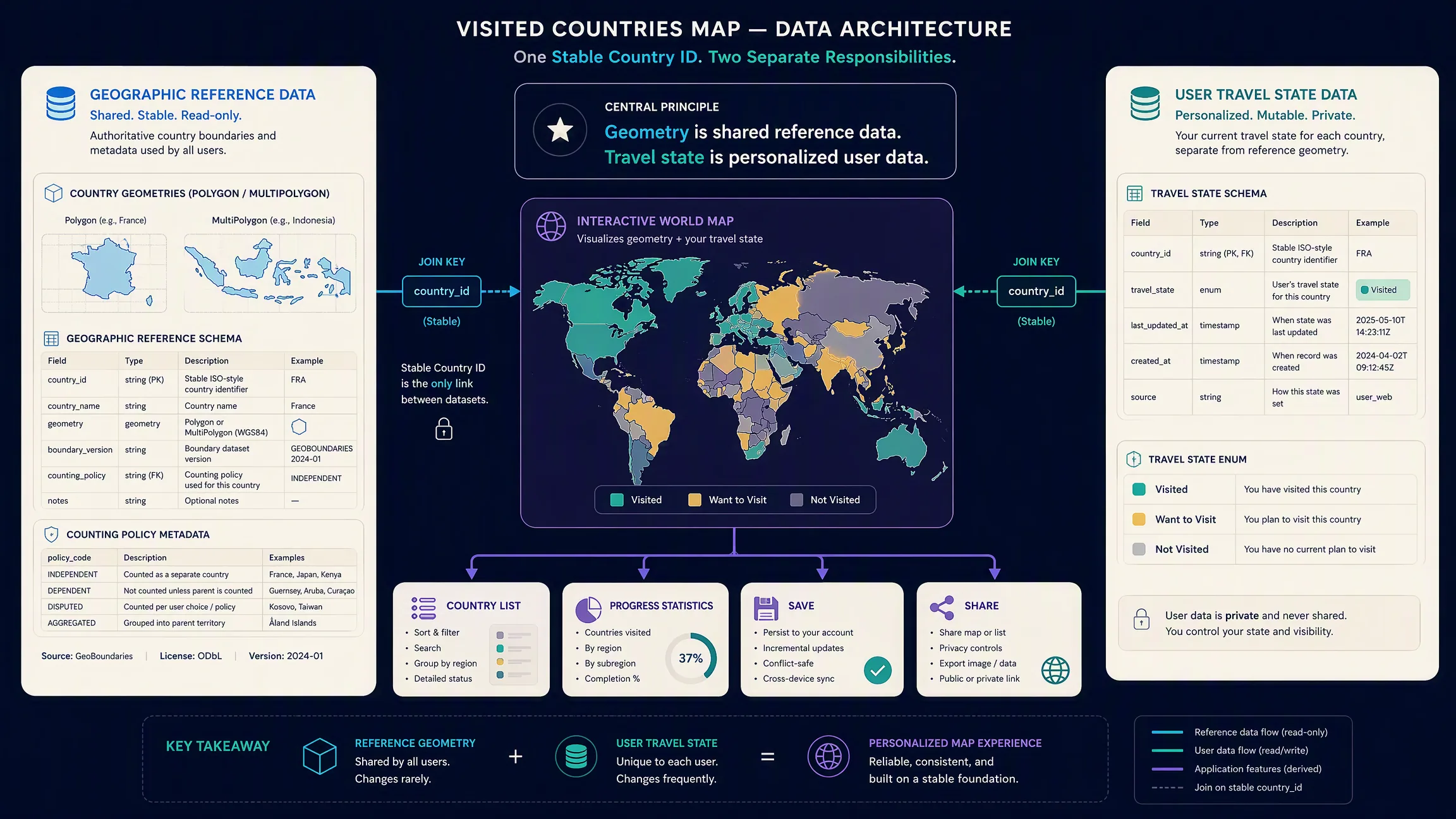
The cleanest architecture separates geographic reference data from personalized travel state. Boundary data holds stable identifiers, display names, polygon or multipolygon geometry, optional region or continent, dataset version, and eligibility under the product’s counting policy. User travel state holds only traveler-owned values such as JP: visited or IS: want_to_visit. Map design may change while travel history should not. Do not encode business state as color alone—store semantic status, then let the renderer decide purple, teal, patterned, or outlined presentation.
Country names are weak database keys because language, abbreviation, punctuation, naming conventions, official changes, and transliteration all vary. ISO 3166 is widely used for standardized country codes, and the ISO 3166 Maintenance Agency maintains the assigned country-code set (ISO 3166). Document which identifier is authoritative—ISO alpha-2, alpha-3, or a boundary provider feature ID—and preserve the mapping between geographic features and user state.
GeoJSON supports both Polygon and MultiPolygon geometries; RFC 7946 defines their structure and uses longitude-first coordinate positions (RFC 7946). Many countries need MultiPolygon geometry because territory includes disconnected islands or other separate areas. For coordinate-order detail, see Search Location Using Latitude and Longitude.
How Do Boundary Datasets and Country Counts Work?
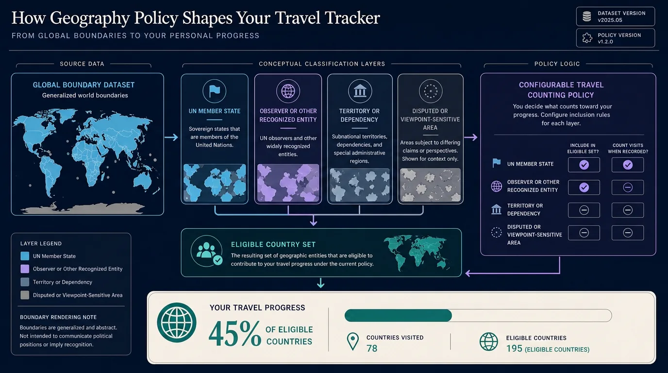
A visited-countries tracker needs a maintained source of country geometry. Natural Earth publishes public-domain map data at 1:10m, 1:50m, and 1:110m scales, including Admin 0 country datasets, and its documentation distinguishes countries, sovereignty, map units, subunits, disputed areas, and optional geographic point-of-view variants (Admin 0 — Countries). A boundary file is not a universal definition of every country. The United Nations Member States list is one possible reference set, but a travel product may handle observer states, territories, dependencies, constituent countries, or disputed entities differently (UN Member States). Do not silently treat the number of GeoJSON features as the number of countries in the world. Make eligibility explicit on each feature and version the counting policy so progress percentages remain explainable.
National boundaries can represent political disputes and different geographic viewpoints. A consumer travel map should not imply that its interface resolves those disputes. Document boundary source, dataset version, counting-policy version, territory handling, and a neutral disclaimer such as boundaries and country counts following the geographic dataset and counting policy used by this map. Do not generate national boundaries with an image model or language model—use maintained geospatial data.
How Do You Render and Update Country Selection?
A simple country tracker loads country GeoJSON into a map source, draws a fill layer, handles selection, updates a user-state store, restyles features, and refreshes progress plus a country list. MapLibre GL JS can render GeoJSON polygon features with a fill layer (Add a GeoJSON polygon). Prefer application-state changes first: toggle status, persist travel state, update style for the affected feature, then recalculate statistics—avoid rebuilding the entire country dataset after every click. Support more than a binary state when the product needs it: visited, want to visit, and not visited cover most tracker intents.
import maplibregl from "maplibre-gl";

const visited = new Set(["JPN", "FRA", "CAN"]);

const map = new maplibregl.Map({
  container: "map",
  style: "https://demotiles.maplibre.org/style.json",
  center: [10, 20],
  zoom: 1.2
});

map.on("load", async () => {
  const countries = await (await fetch("/data/countries.geojson")).json();
  countries.features = countries.features.map((feature) => ({
    ...feature,
    properties: {
      ...feature.properties,
      visit_status: visited.has(feature.properties.iso_a3)
        ? "visited"
        : "not_visited"
    }
  }));
  map.addSource("countries", { type: "geojson", data: countries });
  map.addLayer({
    id: "countries-fill",
    type: "fill",
    source: "countries",
    paint: {
      "fill-color": [
        "match",
        ["get", "visit_status"],
        "visited", "#6f5bd3",
        "want_to_visit", "#72c4c9",
        "#d8d8d8"
      ],
      "fill-opacity": 0.65
    }
  });
});
Confirm the actual property schema of the chosen dataset before implementation. Use accessible colors from your design system rather than the illustrative values above.
How Should Persistence, Accessibility, and Privacy Work?
Anonymous experiences can keep selections in local application state and browser storage on the same device. Signed-in experiences sync an authorized backend travel profile across devices. The map renderer displays state; the renderer should not become the identity or persistence system. Version geography policy metadata alongside saved profiles so later dataset updates do not silently rewrite historical progress.
Add a searchable country list synchronized with the map so tiny countries remain selectable on mobile. Provide keyboard-operable controls, visible focus, and status that is not communicated by color alone. Prefer coarse sharing snapshots—visited counts and public country sets—over exporting exact trip dates, hotels, routes, current location, or future plans by default. Treat wish-list and planned travel as sensitive; do not publish future destinations unless the user explicitly chooses to share them.
AI can help organize categories, suggest denser city layers after country selection, or refine map styling, but user selections remain the authoritative travel history. Do not invent visited countries from model knowledge.
Where Does Kaleidr Studio Fit?
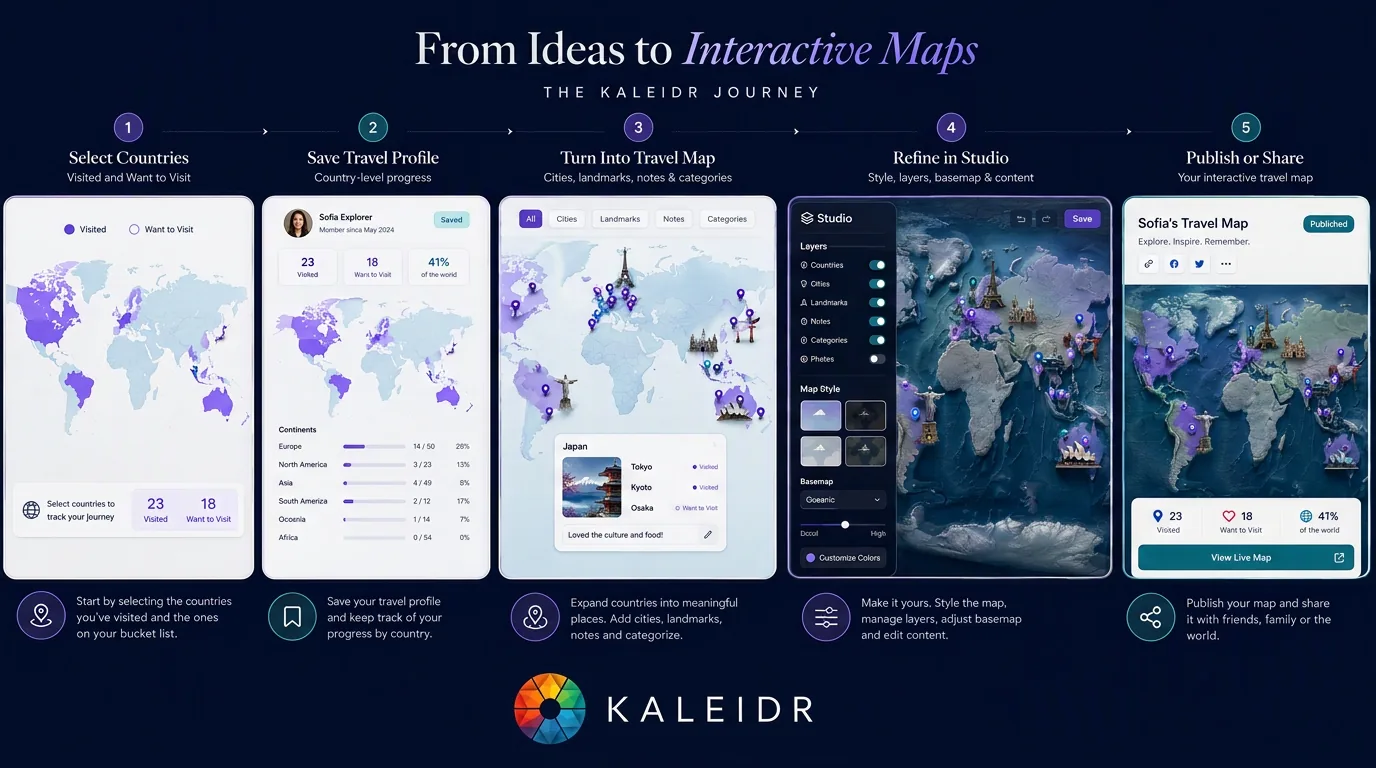
A lightweight tracker can satisfy the search intent first, then hand users into richer map creation. Kaleidr Studio currently supports prompt-first creation of custom interactive maps with data-driven maps, themed regions, markers, layers, visual styling, publishing, and embedding. The public Studio page does not currently document a dedicated visited-country tracker with automatic per-user country-state persistence, a built-in country counter, or a specific visited/wish-list toggle mode—those capabilities should not be described as current Studio features unless implemented and documented. The recommended product path is interactive country tracker → save or share → turn into a richer travel map → refine and publish in Studio. Prefer generalized world geometry for performance, keep user-state payloads tiny, and load city or place detail only when the user asks for it.
Which Mistakes Should Teams Avoid?
| Mistake | What happens | Better approach |
|---|---|---|
| Using country names as the primary key | Localization breaks state | Use stable identifiers |
| Treating fill color as travel data | Theme changes break logic | Store semantic status separately |
| Counting GeoJSON features as countries | Territories distort totals | Define an eligibility policy |
| Hard-coding a universal country total | Assumptions become invisible | Publish the counting policy |
| Ignoring boundary viewpoint | Map appears politically authoritative | Document source and policy |
| Using pins instead of country polygons | Country-level intent is unmet | Make country areas interactive |
| Making tiny states impossible to select | Mobile and accessibility suffer | Add search and a synchronized list |
| Requiring signup before the first click | Acquisition friction increases | Allow local state first where appropriate |
| Sharing exact travel history by default | Privacy risk increases | Share only intended coarse state |
| Using AI as travel-history truth | User state can be invented | Keep user selections authoritative |
Final Verdict
An interactive visited countries map is technically simple only if the product ignores the decisions that make it reliable. The core implementation is country boundaries, stable IDs, user travel state, an interactive fill layer, and saved progress. The harder questions are product questions: what counts as a country, which boundary dataset the map follows, how territories and disputed areas are handled, whether travel state persists across devices, what gets shared publicly, and whether a country-level map can evolve into a richer place-level travel map. For travelers, the best experience begins with the task they searched for—click countries and see the map update immediately. Richer map creation can come next through Kaleidr Studio when users want places, regions, layers, styling, and publishing beyond country progress.
Create a Richer Travel Map With Kaleidr Studio
Turn countries, cities, places, and travel ideas into a customizable interactive map. Start building in Kaleidr Studio when you are ready to move beyond country selection into richer authored travel maps.
FAQs
What is an interactive visited countries map?
An interactive visited countries map is a world map that lets users select countries and save each country’s travel state, typically as visited, want to visit, or not visited.
How is a visited countries map different from a travel map with pins?
A visited countries map highlights national boundaries. A travel map with pins marks specific cities, landmarks, hotels, restaurants, or other places.
What map data do I need?
You need country boundary geometry—usually Polygon or MultiPolygon features—plus stable country identifiers and a separate record of the user’s travel state.
Can I use GeoJSON for country boundaries?
Yes. GeoJSON supports Polygon and MultiPolygon geometry and is widely used for web mapping.
What country code should I store?
ISO 3166 alpha-2 or alpha-3 codes are common choices. Use stable identifiers consistently and document how they map to the chosen boundary dataset.
How many countries should a visited map count?
There is no single denominator every travel product must use. Define whether the tracker counts only a particular reference set, also includes observer states, includes territories, or applies another documented policy.
Why do visited-country apps sometimes show different totals?
They may use different definitions of a country, different boundary datasets, or different treatment of territories and disputed areas.
How should disputed borders be handled?
Use a maintained geographic dataset, document its viewpoint or boundary policy, and avoid implying that the travel application resolves political disputes.
Can the map work without an account?
Yes. Browser local storage can preserve selections on the same device. An account becomes useful for cross-device synchronization, backup, or durable sharing.
Can Kaleidr Studio create travel maps?
Yes. Kaleidr Studio currently supports prompt-first creation of custom interactive maps with themed regions, markers, layers, visual styling, publishing, and embedding. A dedicated per-user visited-country counter or country-toggle tracker is not currently documented on the public Studio page.
References
- International Organization for Standardization. ISO 3166 — Country Codes. Accessed 16 August 2026. https://www.iso.org/iso-3166-country-codes.html
- Internet Engineering Task Force. RFC 7946: The GeoJSON Format. 2016. https://datatracker.ietf.org/doc/html/rfc7946
- Kaleidr. Create Custom Maps with AI Map Maker. Accessed 16 August 2026. https://kaleidr.com/studio
- Kaleidr. Build with Kaleidr. Developer documentation. Accessed 16 August 2026. https://docs.kaleidr.com/
- MapLibre. Add a GeoJSON Polygon. MapLibre GL JS documentation. Accessed 16 August 2026. https://maplibre.org/maplibre-gl-js/docs/examples/add-a-geojson-polygon/
- Natural Earth. Admin 0 — Countries. Version 5.1.1. Accessed 16 August 2026. https://www.naturalearthdata.com/downloads/110m-cultural-vectors/110m-admin-0-countries/
- United Nations. Member States. Accessed 16 August 2026. https://www.un.org/en/about-us/member-states
@misc{iso_3166_country_codes,
  title  = {ISO 3166 -- Country Codes},
  author = {{International Organization for Standardization}},
  note   = {Accessed 16 August 2026},
  url    = {https://www.iso.org/iso-3166-country-codes.html}
}

@misc{rfc7946,
  title  = {RFC 7946: The GeoJSON Format},
  author = {Butler, Howard and Daly, Martin and Doyle, Allan and Gillies, Sean and Hagen, Stefan and Schaub, Tim},
  year   = {2016},
  publisher = {Internet Engineering Task Force},
  url    = {https://datatracker.ietf.org/doc/html/rfc7946}
}

@misc{natural_earth_admin0,
  title  = {Admin 0 -- Countries},
  author = {{Natural Earth}},
  note   = {Version 5.1.1; accessed 16 August 2026},
  url    = {https://www.naturalearthdata.com/downloads/110m-cultural-vectors/110m-admin-0-countries/}
}

@misc{un_member_states,
  title  = {Member States},
  author = {{United Nations}},
  note   = {Accessed 16 August 2026},
  url    = {https://www.un.org/en/about-us/member-states}
}

@misc{maplibre_geojson_polygon,
  title  = {Add a GeoJSON Polygon},
  author = {{MapLibre}},
  note   = {MapLibre GL JS documentation; accessed 16 August 2026},
  url    = {https://maplibre.org/maplibre-gl-js/docs/examples/add-a-geojson-polygon/}
}

@misc{kaleidr_studio_2026_08_16,
  title  = {Create Custom Maps with AI Map Maker},
  author = {{Kaleidr}},
  note   = {Accessed 16 August 2026},
  url    = {https://kaleidr.com/studio}
}

@misc{kaleidr_docs_2026_08_16,
  title  = {Build with Kaleidr},
  author = {{Kaleidr}},
  note   = {Developer documentation; accessed 16 August 2026},
  url    = {https://docs.kaleidr.com/}
}