
Search location using latitude and longitude by validating the coordinate pair, confirming order, centering the map, and optionally reverse-geocoding to a place label. The common mistake is coordinate order: Google-style named lat/lng fields versus longitude-first arrays in GeoJSON, Mapbox GL JS, and MapLibre GL JS. A production tool should validate ranges, preserve the original values, handle empty reverse-geocoding results, and never imply that a returned street address is more precise than the geocoder can determine.
The sections below cover validation, coordinate-order contracts, Google Maps / Mapbox / MapLibre examples, reverse geocoding, GeoJSON, and common failures. Related product context lives on Kaleidr Spatial AI and the developer documentation. After a point is resolved, the nearby places map workflow can use it as a search origin.
Coordinate-search essentials
- Validate first: Latitude is -90…90; longitude is -180…180.
- Know the order: Named fields reduce ambiguity; arrays need an explicit contract.
- Plot before enriching: Place the exact point, then reverse-geocode optionally.
- Preserve originals: Keep the user-supplied coordinates beside any address label.
- Match the API: Google uses
lat/lng; GeoJSON, Mapbox, and MapLibre use[lng, lat].
How Do You Search Location Using Latitude and Longitude?
A coordinate lookup needs a short deterministic sequence: accept latitude and longitude, normalize decimal separators and whitespace, validate latitude against -90 to 90 and longitude against -180 to 180, convert into the coordinate order required by the selected map library, center the map and add a marker, optionally reverse-geocode the point, and show the original coordinates alongside any returned place label. The last step matters. Reverse geocoding is an interpretation of a coordinate, not a replacement for it. Google describes reverse geocoding as translating a map location into a human-readable address and notes that the result is an estimate based on the closest addressable location (Reverse geocoding). Mapbox similarly distinguishes forward geocoding, which converts text into coordinates, from reverse geocoding, which converts coordinates into a text description (Understanding the Geocoding API).
Latitude measures position north or south of the equator; longitude measures position east or west of the prime meridian. For ordinary decimal-degree geographic coordinates, latitude ranges from -90 to 90 and longitude from -180 to 180. A point in Washington, D.C., for example, might be written as latitude 38.8977 and longitude -77.0365. The values alone are not enough: the application must also know which value comes first.
Why Does Coordinate Order Break Map Searches?
Coordinate order is one of the most common sources of broken map searches. Human-readable latitude/longitude is often written latitude first. Google Maps LatLngLiteral uses named lat and lng fields (Coordinates reference). GeoJSON Point, Mapbox GL JS center, and MapLibre GL JS center use longitude-latitude arrays. GeoJSON’s RFC defines position arrays in longitude-latitude order and uses WGS 84 geographic coordinates in decimal degrees (RFC 7946). Mapbox and MapLibre intentionally follow that order for array-based coordinates. Named fields reduce ambiguity; positional arrays require an explicit coordinate-order contract.
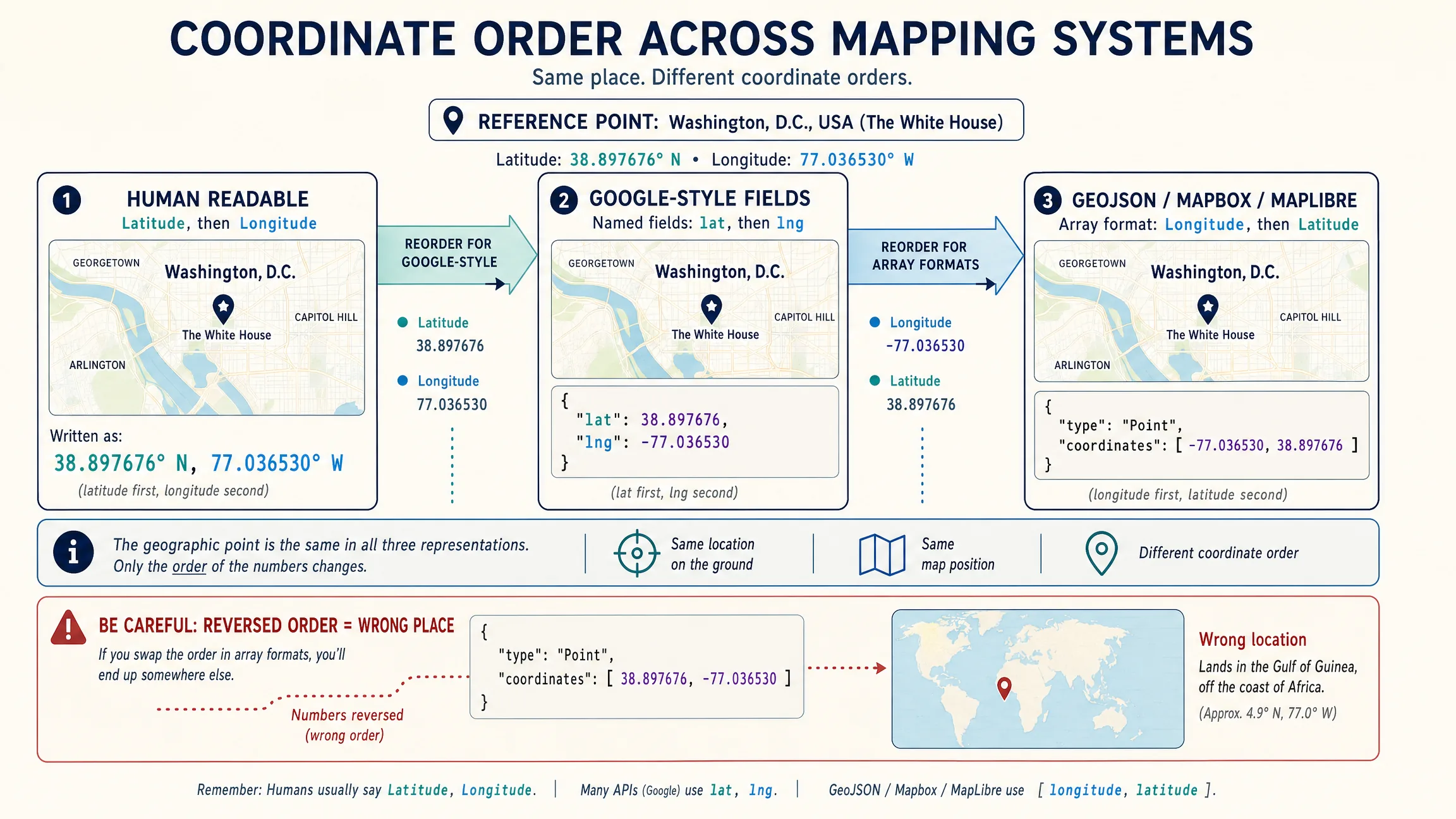
| System | Typical representation | Order |
|---|---|---|
| Human-readable latitude/longitude | 38.8977, -77.0365 |
latitude, longitude |
Google Maps LatLngLiteral |
{ lat: 38.8977, lng: -77.0365 } |
named fields |
| GeoJSON Point | [-77.0365, 38.8977] |
longitude, latitude |
| Mapbox GL JS center | [-77.0365, 38.8977] |
longitude, latitude |
| MapLibre GL JS center | [-77.0365, 38.8977] |
longitude, latitude |
Most web-map coordinate search starts with WGS 84 longitude and latitude in decimal degrees. The EPSG registry identifies WGS 84 geographic 2D as EPSG:4326 and lists its axes as latitude and longitude (EPSG:4326). GeoJSON, however, defines position arrays with longitude first and latitude second. Both statements can be true in their respective specifications: “EPSG:4326 is latitude, longitude” and “GeoJSON coordinates are longitude, latitude.” For application code, follow the contract of the actual API or data format rather than a remembered phrase such as “lat/lon.”
How Should Teams Parse and Validate Coordinates?
A small parser prevents most user-input failures. Accept pairs such as 38.8977, -77.0365, space-separated values, or separate latitude and longitude fields. Require exactly two finite numbers, reject latitude outside -90…90 and longitude outside -180…180, and return named { latitude, longitude } fields for the rest of the application. Do not automatically swap the two values just because the first one falls outside the latitude range; automatic swapping can hide upstream data errors. If the application wants to offer a correction, show it as an explicit suggestion that the values may be reversed.
function parseCoordinatePair(input) {
  const parts = input
    .trim()
    .split(/[\s,]+/)
    .filter(Boolean);

  if (parts.length !== 2) {
    throw new Error("Enter exactly two coordinate values.");
  }

  const latitude = Number(parts[0]);
  const longitude = Number(parts[1]);

  if (!Number.isFinite(latitude) || !Number.isFinite(longitude)) {
    throw new Error("Coordinates must be valid numbers.");
  }

  if (latitude < -90 || latitude > 90) {
    throw new Error("Latitude must be between -90 and 90.");
  }

  if (longitude < -180 || longitude > 180) {
    throw new Error("Longitude must be between -180 and 180.");
  }

  return { latitude, longitude };
}
A basic accessible form should use visible labels rather than placeholders alone, inputmode="decimal" on both fields, a submit control, and a status region with role="status" so keyboard and screen-reader users receive the same feedback as users watching the marker move. Keep textual coordinates outside the map canvas, provide copy feedback, and do not require dragging a marker as the only way to edit coordinates.
How Do Google Maps, Mapbox, and MapLibre Differ?
Google Maps JavaScript API represents geographic points with LatLng or LatLngLiteral, so named lat and lng fields avoid positional-array ambiguity. Current Google documentation recommends Advanced Markers for modern marker workflows (Add a marker). After validation, center the map and create or move a marker with { lat, lng }. Replace demo configuration with the project’s own restricted Google Maps key and production map ID where required.
Mapbox GL JS uses [longitude, latitude] for map center and marker coordinates (Mapbox GL JS; Markers). Build the array as [longitude, latitude], call setLngLat, and flyTo the same point. For address lookup, use an authorized Mapbox geocoding product; Mapbox documents reverse geocoding as converting geographic coordinates into a text description.
MapLibre GL JS also uses longitude-latitude arrays (LngLat; Marker). MapLibre’s documentation explicitly states that the library uses longitude-latitude order to match the GeoJSON specification. MapLibre is a renderer, not a universal geocoding provider: connect an approved geocoding service separately and follow that provider’s licensing, attribution, storage, and credential requirements.
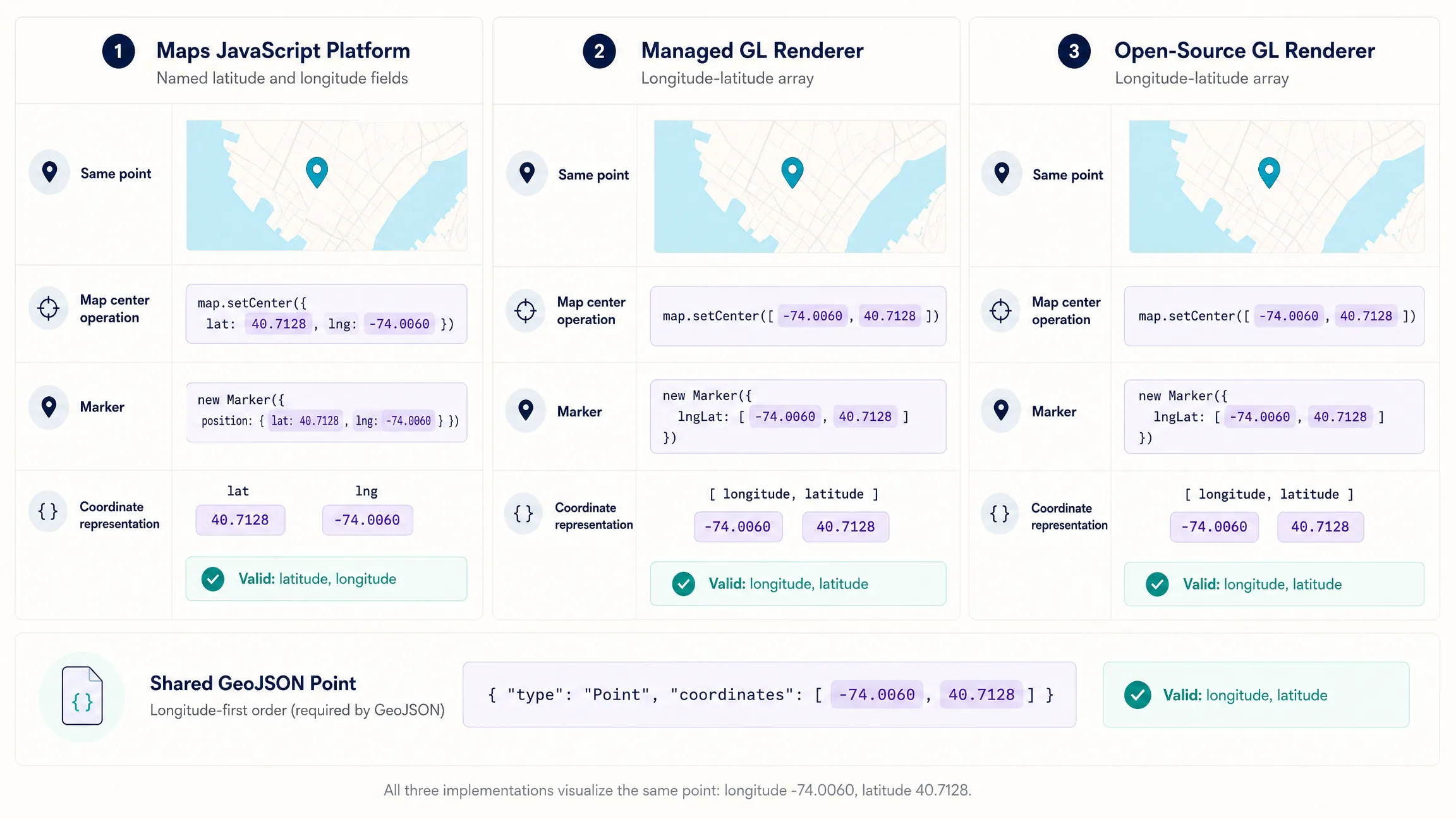
function showGoogleCoordinate(latitude, longitude) {
  const position = { lat: latitude, lng: longitude };
  map.setCenter(position);
  map.setZoom(16);
  marker.position = position;
}

function showLngLatCoordinate(latitude, longitude) {
  const lngLat = [longitude, latitude];
  marker.setLngLat(lngLat);
  map.flyTo({ center: lngLat, zoom: 16, essential: true });
}
When Should Reverse Geocoding Happen?
A marker tells the user where the coordinate lies. Reverse geocoding can add a nearby human-readable address or political area after the point is plotted. Keep both visible—original coordinates and nearest returned address—and handle empty results without removing the marker. Google notes that reverse geocoding is not exact and may return results at several geographic levels, from a street address to a neighborhood, city, county, or state (Maps JavaScript reverse geocoding example).
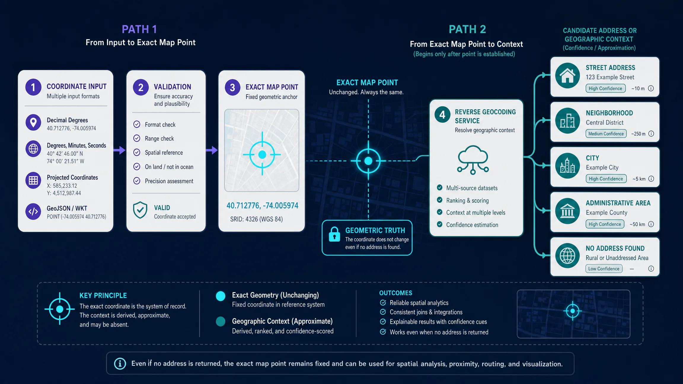
These workflows solve opposite problems. Forward geocoding turns an address or place name into coordinates and candidates. Reverse geocoding turns coordinates into human-readable context. Direct coordinate search plots an exact map point from coordinates. Nearby search uses a coordinate or place origin plus criteria to return nearby places. If the user already has coordinates, do not geocode them before placing the point. Plot the exact coordinate first; reverse geocoding is optional enrichment. Once a coordinate becomes the search origin, the application can retrieve nearby places, rank them by distance or travel time, and let the user refine the result.
Once the coordinate is validated, a GeoJSON Point creates a portable geographic object that can move between many web mapping systems. The coordinates array is again [longitude, latitude]. A useful utility can expose copy as latitude/longitude, copy as longitude/latitude, copy as GeoJSON, copy as a share URL, open in the current map, reverse-geocode, and add the point to a project.
function toGeoJSONPoint(latitude, longitude) {
  return {
    type: "Feature",
    geometry: {
      type: "Point",
      coordinates: [longitude, latitude]
    },
    properties: {
      source: "coordinate-search"
    }
  };
}
What About DMS, UTM, Precision, and AI?
Many coordinate searches use decimal degrees, but users may arrive with degrees-minutes-seconds notation. Conversion is degrees plus minutes divided by 60 plus seconds divided by 3600, with a negative sign for west and south. For a production utility, do not accept DMS unless the parser is fully tested for hemisphere letters, Unicode degree symbols, missing seconds, negative signs combined with hemisphere suffixes, malformed minutes or seconds above 60, and localization. A smaller, reliable decimal-degree tool is better than a parser that silently misinterprets coordinates.
UTM uses projected eastings and northings rather than latitude and longitude. The EPSG registry defines WGS 84 / UTM as a zoned projected CRS with separate zones and meter-based coordinates. A UTM search therefore needs a zone and hemisphere or an unambiguous CRS identifier; do not treat easting and northing as latitude and longitude. More decimal places imply a more precise representation, but they do not guarantee equal measurement accuracy. Choose display precision for the workflow, preserve the full stored coordinate, and do not market centimeter accuracy merely because a number contains many decimals.
A coordinate lookup itself does not require AI. The deterministic workflow is parse, validate, plot, and optionally reverse-geocode. AI becomes useful after the geographic point is established—for questions about what is around the coordinate, groceries within a drive, neighborhood context, hotels between the point and an airport, or comparing candidate sites. Kaleidr Spatial AI is designed around question-based place exploration. Developers can also attach Kaleidr Chat to an existing Mapbox, Google Maps, or MapLibre map so a resolved coordinate becomes context for natural-language exploration; see AI chat on Mapbox, Google Maps, and MapLibre. The existing renderer still owns the map; authoritative place and routing services remain responsible for factual answers.
Which Mistakes and Edge Cases Matter Most?
| Mistake | What happens | Recommended correction |
|---|---|---|
| Assuming every API uses latitude first | Points appear in the wrong country or fail validation | Document coordinate order at every boundary |
| Silently swapping inputs | Upstream data errors become invisible | Offer an explicit swap suggestion |
| Reverse-geocoding before plotting | A fuzzy address replaces the exact coordinate | Plot first; enrich second |
| Treating reverse geocoding as exact | Users may believe a nearby address is the exact point | Show both the original coordinate and returned label |
| Storing only formatted addresses | Precision and interoperability are lost | Preserve the original coordinates and stable IDs |
| Accepting invalid ranges | The renderer clamps, wraps, or behaves unpredictably | Validate before the provider call |
| Treating MapLibre as a geocoder | The app has no source for address lookup | Connect an approved geocoding service separately |
Mixing [lat, lng] with GeoJSON |
Data shifts to the wrong location | Use [lng, lat] in GeoJSON |
| Hiding all output inside the canvas | Accessibility and search visibility suffer | Render a text result beside the map |
| Claiming excessive precision | The UI overstates source accuracy | Separate numeric precision from measurement accuracy |
Handle reversed inputs with an explicit suggestion, reject out-of-range values, keep 0,0 valid but flaggable in data-quality workflows, report empty reverse-geocode results without removing the point, avoid forcing ocean or remote coordinates into a street address, preserve originals near the antimeridian, and use stable record identifiers rather than assuming coordinate equality means entity equality. Public pages should explain the utility in crawlable text; one strong utility and one authoritative guide beat thin synonym pages for every phrasing of the same task.
Final Verdict
Searching a map by latitude and longitude is one of the simplest spatial workflows, but it exposes an important engineering truth: coordinate meaning depends on the contract around the numbers. Validate the values, make coordinate order explicit, plot the exact point first, and treat reverse geocoding as contextual enrichment rather than a replacement for the coordinate. Google Maps commonly uses named lat and lng fields; GeoJSON, Mapbox, and MapLibre use longitude-latitude order in coordinate arrays.
For Kaleidr, the highest-value next step is not to turn this deterministic lookup into an AI task. A coordinate should first become a reliable geographic anchor. Spatial AI can then help the user ask richer questions about the area, nearby places, routes, or contextual relationships around that point.
Explore the Area Around a Coordinate
After locating a point, use Kaleidr Spatial AI to ask contextual questions about nearby places and geographic relationships. Open Kaleidr Spatial AI to explore around a resolved coordinate, then deepen developer integration through the developer documentation when the host already owns the map.
FAQs
How do I search a location using latitude and longitude?
Enter a valid latitude between -90 and 90 and longitude between -180 and 180, convert them into the order required by the map API, center the map on the point, and add a marker. Reverse geocoding is optional if you also want a human-readable address.
Which comes first, latitude or longitude?
It depends on the interface. Human-readable coordinates are often written latitude first. Google Maps JavaScript commonly uses named lat and lng fields. GeoJSON, Mapbox GL JS, and MapLibre GL JS use longitude first in coordinate arrays.
Why does my coordinate show the wrong place?
The most common cause is reversed coordinate order. Another possibility is an incorrect coordinate reference system, especially when projected coordinates such as UTM eastings and northings are mistaken for decimal-degree latitude and longitude.
What is reverse geocoding?
Reverse geocoding converts a geographic coordinate into a human-readable address or geographic description. The result is an estimate based on the provider’s data and matching logic.
Is GeoJSON latitude-longitude or longitude-latitude?
GeoJSON position arrays use longitude first and latitude second.
Is EPSG:4326 the same as GeoJSON?
No. EPSG:4326 identifies the WGS 84 geographic 2D coordinate reference system. GeoJSON is a data format that uses WGS 84 coordinates but defines position arrays in longitude-latitude order.
Can I search UTM coordinates the same way?
Not directly. UTM requires a zone, hemisphere or CRS identifier, and projected easting/northing values. Convert through a tested CRS transformation before treating the point as longitude and latitude.
Does MapLibre include reverse geocoding?
MapLibre GL JS is primarily a renderer. Reverse geocoding comes from a separate geocoding service selected by the host application.
Should I use AI to find a coordinate?
Not for basic coordinate lookup. Parsing, validation, plotting, and reverse geocoding are deterministic tasks. AI becomes useful after the point is known and the user wants contextual or multi-variable exploration.
Can Kaleidr work with a coordinate-centered map?
Yes. The host map can be centered on the resolved coordinate first, then Kaleidr Chat can attach to a supported live map for map-aware location questions. The host map and authoritative services remain responsible for exact coordinates and factual place data.
References
- EPSG. WGS 84 — EPSG:4326. EPSG Geodetic Parameter Dataset. Accessed 10 August 2026. https://epsg.org/crs_4326/WGS-84.html
- Google. Coordinates — Maps JavaScript API. Accessed 10 August 2026. https://developers.google.com/maps/documentation/javascript/reference/coordinates
- Google. Reverse geocode a location — Geocoding API. Accessed 10 August 2026. https://developers.google.com/maps/documentation/geocoding/reverse-geocoding
- Google. Reverse Geocoding — Maps JavaScript API. Accessed 10 August 2026. https://developers.google.com/maps/documentation/javascript/examples/geocoding-reverse
- Google. Add a marker to a map — Maps JavaScript API. Accessed 10 August 2026. https://developers.google.com/maps/documentation/javascript/advanced-markers/add-marker
- IETF. RFC 7946: The GeoJSON Format. Accessed 10 August 2026. https://datatracker.ietf.org/doc/html/rfc7946
- Kaleidr. AI Map Platform & Spatial Intelligence. kaleidr.com. Accessed 10 August 2026. https://kaleidr.com/
- Kaleidr. AI Maps You Can Talk To — Spatial AI. kaleidr.com. Accessed 10 August 2026. https://kaleidr.com/ai
- Kaleidr. Introduction. Kaleidr Developer Docs. Accessed 10 August 2026. https://docs.kaleidr.com/
- Mapbox. Mapbox GL JS. Accessed 10 August 2026. https://docs.mapbox.com/mapbox-gl-js/
- Mapbox. Markers — Mapbox GL JS. Accessed 10 August 2026. https://docs.mapbox.com/mapbox-gl-js/guides/add-your-data/markers/
- Mapbox. Understanding the Geocoding API. Accessed 10 August 2026. https://docs.mapbox.com/help/dive-deeper/geocoding/
- MapLibre. Introduction — MapLibre GL JS. Accessed 10 August 2026. https://maplibre.org/maplibre-gl-js/docs/
- MapLibre. LngLat — MapLibre GL JS. Accessed 10 August 2026. https://maplibre.org/maplibre-gl-js/docs/API/classes/LngLat/
- MapLibre. Marker — MapLibre GL JS. Accessed 10 August 2026. https://maplibre.org/maplibre-gl-js/docs/API/classes/Marker/
@misc{ietf_geojson,
  title  = {RFC 7946: The GeoJSON Format},
  author = {{Internet Engineering Task Force}},
  note   = {Accessed 10 August 2026},
  url    = {https://datatracker.ietf.org/doc/html/rfc7946}
}

@misc{epsg_wgs84,
  title  = {WGS 84 -- EPSG:4326},
  author = {{EPSG}},
  note   = {Accessed 10 August 2026},
  url    = {https://epsg.org/crs_4326/WGS-84.html}
}

@misc{google_coordinates,
  title  = {Coordinates -- Maps JavaScript API},
  author = {{Google}},
  note   = {Accessed 10 August 2026},
  url    = {https://developers.google.com/maps/documentation/javascript/reference/coordinates}
}

@misc{google_reverse_geocode,
  title  = {Reverse geocode a location},
  author = {{Google}},
  note   = {Geocoding API; accessed 10 August 2026},
  url    = {https://developers.google.com/maps/documentation/geocoding/reverse-geocoding}
}

@misc{mapbox_geocoding,
  title  = {Understanding the Geocoding API},
  author = {{Mapbox}},
  note   = {Accessed 10 August 2026},
  url    = {https://docs.mapbox.com/help/dive-deeper/geocoding/}
}

@misc{maplibre_lnglat,
  title  = {LngLat -- MapLibre GL JS},
  author = {{MapLibre}},
  note   = {Accessed 10 August 2026},
  url    = {https://maplibre.org/maplibre-gl-js/docs/API/classes/LngLat/}
}