
Neighborhood intelligence real estate connects property inventory with travel time, nearby places, transit, search areas, and customer-selected destinations. A language model can interpret natural-language living constraints, while the listing system stays authoritative for bedrooms, price, availability, and amenities, and geospatial services calculate the spatial relationships.
The sections below separate property facts from neighborhood context, then cover architecture, ranking, fair-housing governance, and measurement. Related reading includes Location Intelligence vs. Spatial AI, How to Build a Map-Aware AI Assistant, and Location Intelligence Customer Experience. Teams already choosing an implementation shape can skip to the Kaleidr mapping; teams still naming the data boundary should start with the property-versus-context distinction.
Neighborhood intelligence real estate essentials
- Inventory first: Active listings, price, availability, and property amenities stay in the host listing system.
- Context second: Travel time, nearby places, transit, parks, and search areas come from spatial and place services.
- Hard filters before ranking: Bedrooms, budget, pets, parking, and availability are eligibility, not soft preference.
- Visible criteria: Commute minutes, amenity distance, and search areas should appear as inspectable state on map and list.
- Measure outcomes: Saves, tours, and inquiries beat interaction volume or map pans alone.
Why Is Neighborhood Intelligence Real Estate a B2B Product Problem?
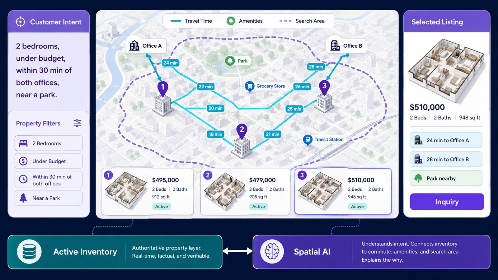
Real-estate marketplaces, brokerages, rental platforms, multifamily operators, and proptech products already hold substantial first-party inventory. Plotting those records as map markers is no longer the scarce capability. The product problem is helping a customer see which listing fits the places and routines that matter to them. A property exists at one coordinate; a housing decision depends on a network of relationships to workplaces, customer-selected schools or childcare, transit, groceries, parks, healthcare, family destinations, and a search area.
Consequently, property search is a strong Spatial AI use case rather than a mapping cosmetic. Kaleidr currently names Neighborhood AI for listings as a real-estate workflow that gives buyers and renters place context tied to inventory and search areas (AI Map Chat for Customer Discovery). Kaleidr also lists Real Estate among the verticals on its public Spatial AI platform page (AI-Powered Map Experiences for Business). Those pages are authoritative about Kaleidr's own positioning; they are not evidence that every listing platform must buy a full conversational stack.
How Does Neighborhood Intelligence Real Estate Differ From Property Data?
Property data describes the unit or parcel. Neighborhood intelligence describes the spatial context around that unit and its relationship to places the customer cares about. Property data includes price, bedrooms, bathrooms, square footage, property type, availability, amenities, and listing status. Neighborhood context includes travel time to selected destinations, nearby places, transit access, parks, search areas, and route-based relationships such as reachable within a time budget.
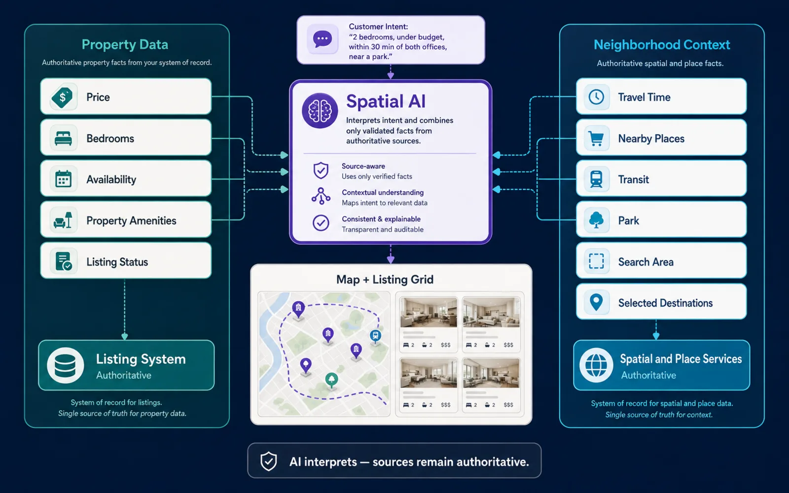
The distinction matters because the two classes have different owners. The listing system should remain authoritative for availability, price, bedrooms, bathrooms, property amenities, status, photos, and lease or transaction details. Place services own external places, category, coordinates, and verified hours where supported. Geospatial services own route geometry, distance, and travel-time estimates. The language model interprets intent, extracts constraints, and explains results as transparent criteria; it does not become the inventory ledger.
In practice, a listing can satisfy every property filter and still be wrong for the customer. Two-bedroom listings under budget with parking and pet-friendly terms may both pass hard filters until the customer adds that they work downtown three days a week, a partner works near a university, and they want a grocery store and park nearby. Ordinary listing filters were not designed for that compound spatial intent.
How Is Property Search Moving Toward Conversation?
Real-estate search is increasingly offering conversational interfaces beside the familiar filter grid. In June 2026, CoStar Group launched Apartments.com AI, describing a conversational apartment-search experience intended to help renters discover, compare, and evaluate properties using natural language and CoStar's own multifamily data (CoStar Group press release). The launch is evidence that at least one major listing platform is shipping natural-language search against first-party inventory. The launch is not evidence that a conversational panel attached to a map is sufficient.
The hard part is grounding the conversation. The application layer must keep the AI map assistant attached to actual inventory, location data, geographic calculations, inspectable criteria, fair-housing controls, and synchronized map state. Private Location Data for AI Map Workflows covers authorization for inventory the host does not expose publicly.
What Should a Production Property-Search Architecture Include?
A production path should run from the host application through authorization and business rules, then active inventory retrieval, hard property constraints, spatial calculation, eligibility, ranking, explanation, synchronized map and list output, and outcome analytics. Generating a recommendation first and checking business reality afterward inverts that order. The inverted path produces places the customer cannot actually use.
Active inventory is the authoritative candidate set. Search, map markers, assistant answers, and inquiry handoffs should reference the same listing identifiers. If a unit is unavailable, off-market, or outside the customer's search area, the product should remove it before ranking or explanation rather than apologize afterward. Stable listing IDs matter when units share one building, prices change, listings are relisted, or multiple inventory sources overlap.
Shared map and listing state keeps map, list, conversation, filters, and saved-search UI on one canonical object. Selecting a listing card should highlight the same map feature; selecting a marker should open the same card; asking the assistant about the selected listing should resolve that listing identifier; changing a commute threshold should update map and list together. A second, invisible assistant-only result set breaks that contract.
Draw-to-search remains valuable alongside natural language. A customer may know they want to live inside a drawn area more precisely than they can describe it in words. A strong interface therefore combines a polygon, property filters, natural-language intent, and the map. Kaleidr currently describes a property template with a listing grid, a synchronized map, draw-to-search areas, and AI neighborhood answers; the live starter is Kaleidr Property.
Exact geometry still belongs to a spatial engine. OGC Simple Feature Access, also published as ISO 19125-1, defines the common architecture for simple feature geometry and the spatial operations implementations expose for points, curves, surfaces, and collections (Simple Feature Access — Part 1). Production systems should let the language model interpret intent and choose an operation, while a geospatial engine calculates distance, route, intersection, and containment.
How Should Hard Constraints Differ From Spatial Preferences?
Hard eligibility is binary: the listing is active, the bedroom count matches, the price fits, pets are allowed, parking exists, or the unit is available on the requested date. Soft preference is comparative: shorter travel time, a better amenity mix, a preferred floor plan, or a lower price among eligible options. The system should apply hard constraints before ranking preferences. A convenient coordinate for a closed or unavailable listing is not a good first result.
Location is not synonymous with nearest-neighbor search. The closest coordinate can be wrong when walking time, parking, transit, route direction, service area, entrance location, or accessibility decides the trip. Useful relationships include near, inside, along a route, reachable within a time budget, same service area, between two points, closest by route, and inside the selected map area. The product should calculate the relationship the decision requires and show that relationship as a reason on the card. Place Ranking API covers eligibility-before-preference in the programmable form.
Why Is Multi-Anchor Property Search Difficult for Ordinary Filters?
Multi-anchor search evaluates a listing relative to several important destinations, such as two workplaces, an airport, a childcare location the customer selected, or another customer-selected point. Radius search around one pin cannot express “within 30 minutes of both offices,” because the feasible set is the intersection of two travel-time areas, not a circle. Ordinary bedroom-and-price filters have no place to put that constraint.
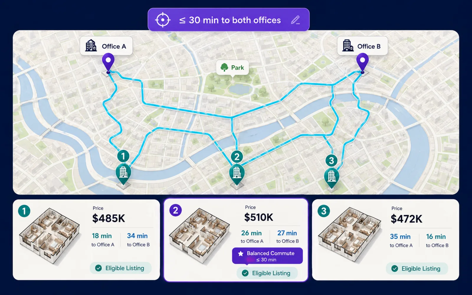
A useful comparison view keeps the same listing identifiers on the map, the list, and any matrix. The table below is an illustration of inspectable tradeoffs, not a ranking recommendation. Price, commute minutes, and amenity walk times should remain editable criteria the customer can change.
| Listing | Price | Office A | Office B | Park | Grocery |
|---|---|---|---|---|---|
| A | $3,050 | 21 min | 29 min | 6 min walk | 8 min walk |
| B | $2,900 | 32 min | 18 min | 3 min walk | 14 min walk |
| C | $3,150 | 24 min | 25 min | 12 min walk | 5 min walk |
The best listing for the customer may be neither closest to Office A nor closest to Office B. Ranking should reflect the customer's stated threshold or weighting, not a hidden composite label. A listing that balances both commutes can outrank a listing that is nearest to only one office.
When Is Travel Time More Useful Than Distance?
Distance remains useful for simple proximity questions. Travel time is often more useful for commute questions because it reflects the transportation network and travel mode. A straight-line radius can treat two listings on opposite sides of a river as equally near an office when only one is reachable in the customer's mode. The interface should show the actual amenity and relationship, not a vague neighborhood label. “Three grocery stores within a 10-minute drive” and “park 0.4 miles away” are inspectable; “great lifestyle neighborhood” is not.
Prefer a collection of objective signals over one opaque neighborhood score. Commute to a selected office, nearest grocery walk time, nearest park distance, and transit station walk time let the customer decide what matters. If a composite score is used internally, document inputs, geography, versioning, and bias testing, and avoid implying a universal definition of neighborhood quality. What Are Local Amenities? covers mapping nearby places without collapsing them into a slogan.
How Should a Language Model Explain Property Results?
A property recommendation should have factual reasons tied to listing inventory, an approved place source, a spatial calculation, or an explicit customer preference. Every reason on a card should trace to one of those sources. Claims such as “this is the perfect neighborhood for you” fail that test when the product cannot define and substantiate what the claim means.
The language model should return constraints as inspectable state, not bury them in conversation history. A request such as “two bedrooms within 30 minutes of both offices near a park” should become visible filters, anchors, and thresholds the customer can edit. How to Build a Map-Aware AI Assistant covers shared map state and validated actions for that handoff.
Which Real-Estate Products Benefit From Neighborhood Context?
The same architecture applies across several inventory owners, with different candidate sets. A brokerage can use commute and amenity context to narrow active listings for a buyer consultation instead of handing over an undifferentiated metro list. A rental marketplace can connect rent, lease dates, and availability to commute and daily-life places so the next step is a tour or application rather than another map pan. A multifamily operator can compare its own communities against customer-selected destinations without opening the entire market.
New-development marketing can use travel-time relationships and nearby places as spatial storytelling while the property system stays authoritative for units and pricing. A real-estate SaaS product can expose the same decision layer to brokers, leasing teams, and managers rather than shipping another map widget. In each case the host still owns inquiry, tour booking, and transaction workflow; the spatial layer returns stable listing identifiers, inspectable reasons, and a structured next action the host already supports.
How Should Fair Housing Shape Neighborhood Search Products?
Real-estate conversational search needs explicit fair-housing governance. The U.S. Fair Housing Act prohibits housing discrimination based on race, color, national origin, religion, sex, familial status, and disability (Housing Discrimination Under the Fair Housing Act). A property-search product should not use protected characteristics to steer customers toward or away from housing. Requests that ask for neighborhoods “for” or “without” a protected class belong in a reject-or-redirect path, not in ranking.
Even when a user does not name a protected class, certain ranking features can function as proxies. Teams should review demographic variables, inferred household traits, personalized neighborhood labels, behavioral models, and recommendation features with product, legal, and data review. The product should not infer race, religion, national origin, disability, familial status, or sex to personalize housing recommendations. Explicit spatial preferences—near a selected park, within 25 minutes of an office, step-free entrance required—are materially different from “find an area for families like mine.” Accessibility needs the customer states explicitly should be treated as property requirements backed by authoritative listing data, not as inferred disability.
Neighborhood products frequently receive questions about school quality and crime. HUD issued a 2026 letter clarifying its current view that sharing crime-rate or school-quality information does not, by itself, constitute unlawful steering when the conduct is not based on protected characteristics (HUD Empowers Real Estate Agents to Better Support American Homebuyers). The letter does not make these data sources simple. A B2B platform should still define source, geography, date, methodology, equal presentation, and applicable state and local requirements, and obtain legal review—and avoid generated labels such as “safe neighborhood” or “family neighborhood” when the product cannot substantiate them. The discussion here is descriptive of public HUD materials; whether a given feature is lawful for a specific product is a question for qualified counsel.
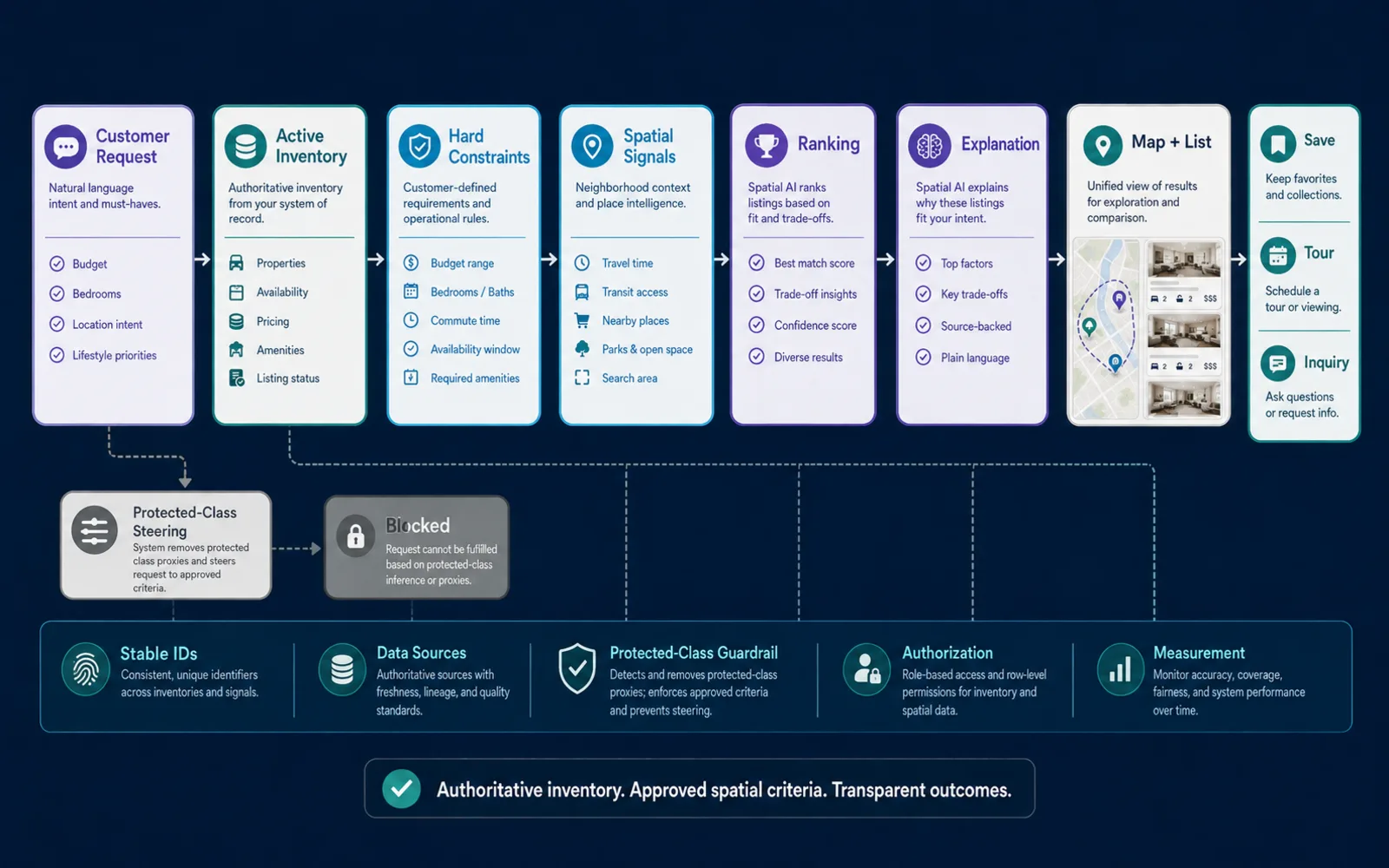
The application and infrastructure enforce permissions, tenant isolation, and private-inventory authorization; the language model does not. Server credentials belong in the application layer. Kaleidr currently documents a publishable key for browser SDK use and a server key for trusted application-layer calls, and states that a publishable key presented as a bearer is rejected (Auth & scopes).
What Should Teams Measure in a Neighborhood Search Pilot?
Task completion matters more than interaction volume. Useful events include search success, eligible-inventory size, no-result reasons, listing selection, spatial-comparison usage, saves, tours, inquiries, and geographic demand or inventory gaps. Chat message counts, marker clicks, and map pans are weak proxies for whether the customer found a place they could actually pursue.
No-result reasons are especially informative. A zero-hit query may mean the inventory is thin in that commute band, the hard filters are too tight, or the geospatial service failed—three different product responses. Spatial Analytics Dashboard KPIs for Map Products lists outcome metrics worth tracking once the workflow is live. Kaleidr currently describes analytics as measuring what customers search, explore, and act on across places and journeys (Map Engagement and Location Analytics).
How Does Kaleidr Map Onto Property Search?
Kaleidr is designed to add a conversational spatial layer around existing inventory rather than replace a listing database or MLS. Its Spatial AI page names Neighborhood AI for listings, describes grounding on business inventory and policies, and describes attaching the conversational layer to an existing compatible map (AI Map Chat for Customer Discovery). Kaleidr Chat documentation currently supports attaching the assistant to a live host Mapbox, MapLibre, Google Maps, or Leaflet map so the property platform keeps its renderer and application state (Chat attach).
| Layer | Role in property search |
|---|---|
| Host listing system | Authoritative inventory, price, availability, inquiry handoff |
| Geospatial services | Travel time, routes, containment, search areas |
| Kaleidr Spatial AI | Intent interpretation, grounded explanation, map-aware assistant |
| Kaleidr Analytics | Search success, selection, spatial comparison, outcomes |
| Kaleidr Enterprise | SDKs, inference APIs, and deployment support for existing stacks |
Depending on the configuration, a Kaleidr implementation can coordinate retrieval, geospatial services, map behavior, and analytics inside the host experience. Confirm current plan allowances on Pricing & Plans before depending on a specific production workflow. Treat the current developer documentation as the integration contract; marketing pages describe the use case, not the endpoint list.
What Limitations and Tradeoffs Should Teams Expect?
Neighborhood context does not replace listing quality, photos, or pricing discipline. Travel-time estimates depend on mode, time of day, and network data, and they remain estimates rather than guarantees. Amenity “nearby” claims are only as good as the place catalog and the distance or time threshold the product discloses. Draw-to-search, conversation, and filters each miss something the others catch; using one surface alone is usually worse than combining them.
Composite neighborhood scores trade explainability for compactness. Fair-housing review, proxy analysis, and counsel involvement add time before launch. Attaching an assistant to an existing map is usually cheaper than replacing the renderer, but the host still has to own authorization, listing identity, and the inquiry or tour handoff. Those constraints are product choices, not reasons to skip the spatial layer.
How Should Teams Start a B2B Pilot?
Start with one inventory source, one customer journey, and one measurable outcome such as qualified tour requests or saved searches. Define canonical listing IDs, hard property constraints, approved spatial signals, protected-class guardrails, and analytics events before expanding to additional markets or data vendors. A practical pilot includes active inventory sync, multi-anchor or travel-time comparison for at least one use case, editable assistant-interpreted constraints, mobile list-and-map parity, host-controlled inquiry or tour handoff, documented data sources, and counsel review for school or crime data if used.
Explore Kaleidr Spatial AI to add Neighborhood AI for listings on an existing map. Explore Kaleidr Enterprise for SDKs, inference APIs, analytics, and deployment support around a current property stack. Confirm the current public pages before treating any example in this article as a shipping contract.
FAQs
What is neighborhood intelligence in real estate?
Neighborhood intelligence connects property listings with geographic context such as commute time, nearby amenities, transit, selected destinations, search areas, and other location relationships that help a customer compare where a property fits.
How is neighborhood intelligence different from property data?
Property data describes the home or unit itself. Neighborhood intelligence describes the geographic context around the property and its relationship to places the customer cares about.
What is Neighborhood AI?
Neighborhood AI, as Kaleidr currently uses the phrase, is a real-estate workflow in which an AI map assistant interprets natural-language location preferences and connects them to structured property and spatial data. The assistant should not invent neighborhood facts or listing availability.
Can Spatial AI improve real-estate search?
Spatial AI can translate requests such as “two bedrooms within 30 minutes of both offices near a park” into structured property and geographic criteria, then help explain the results on an interactive map. The listing system still has to supply truthful inventory.
Should a real-estate platform use a neighborhood score?
Only when the score has a clearly defined purpose, inputs, methodology, and governance. For customer search, transparent criteria such as travel time and nearby amenities are often easier to explain.
Can an assistant recommend the best neighborhood for families?
Real-estate teams should be cautious with subjective demographic or household-based neighborhood recommendations. Fair-housing rules prohibit discrimination based on protected characteristics. Prefer customer-selected objective criteria and obtain legal review for housing recommendation features.
Can real-estate platforms show crime or school information?
HUD's 2026 letter states that sharing crime-rate or school-quality information does not by itself constitute unlawful steering when it is not based on protected characteristics. Platforms should still use sourced, consistently presented data and review applicable federal, state, and local requirements with counsel.
Should property search use distance or travel time?
Travel time is often more useful for commute questions because it reflects the transportation network and travel mode. Distance remains useful for simpler proximity questions.
What is multi-anchor property search?
Multi-anchor search evaluates a listing relative to several important destinations, such as two workplaces, an airport, or another customer-selected location.
Can Kaleidr work with an existing property map?
Kaleidr Chat documentation currently supports attaching the conversational layer to an existing compatible map, allowing the host product to retain its renderer and application state.
Does Kaleidr replace the listing database or MLS?
Replacement is not the recommended architecture. The host real-estate system should remain authoritative for inventory, listing status, price, and property facts. Kaleidr can add conversational spatial intelligence and map-aware interaction around those systems.
What should a B2B real-estate team measure?
Measure search success, eligible inventory, no-result reasons, listing selection, spatial comparison usage, saves, tours, inquiries, and geographic demand or inventory gaps.
References
- Kaleidr. AI Map Chat for Customer Discovery. Accessed 4 September 2026. https://kaleidr.com/ai
- Kaleidr. AI-Powered Map Experiences for Business. Accessed 4 September 2026. https://kaleidr.com/
- CoStar Group. CoStar Group Launches Apartments.com AI, Redefining the Future of Apartment Search. 16 June 2026. https://costargroup.gcs-web.com/news-releases/news-release-details/costar-group-launches-apartmentscom-ai-redefining-future
- Open Geospatial Consortium. Simple Feature Access — Part 1: Common Architecture. OGC 06-103r4 / ISO 19125-1. Accessed 4 September 2026. https://www.ogc.org/standards/sfa/
- Kaleidr. Kaleidr Property. Template. Accessed 4 September 2026. https://template.kaleidr.com/customize/?template=property
- Kaleidr. Chat attach. Developer documentation. Accessed 4 September 2026. https://docs.kaleidr.com/sdk/chat-attach
- Kaleidr. Auth & scopes. Developer documentation. Accessed 4 September 2026. https://docs.kaleidr.com/platform-api/auth-and-scopes
- U.S. Department of Housing and Urban Development. Housing Discrimination Under the Fair Housing Act. Accessed 4 September 2026. https://www.hud.gov/helping-americans/fair-housing-act-overview
- U.S. Department of Housing and Urban Development. HUD Empowers Real Estate Agents to Better Support American Homebuyers. 24 April 2026. https://www.hud.gov/news/hud-no-26-028
- Kaleidr. Map Engagement and Location Analytics. Accessed 4 September 2026. https://kaleidr.com/analytics
- Kaleidr. Location Intelligence APIs and Map SDK. Accessed 4 September 2026. https://kaleidr.com/enterprise
@misc{kaleidr_neighborhood_ai_2026_09_04,
  title  = {AI Map Chat for Customer Discovery},
  author = {{Kaleidr}},
  note   = {Accessed 4 September 2026},
  url    = {https://kaleidr.com/ai}
}

@misc{kaleidr_home_spatial_ai_2026_09_04,
  title  = {AI-Powered Map Experiences for Business},
  author = {{Kaleidr}},
  note   = {Accessed 4 September 2026},
  url    = {https://kaleidr.com/}
}

@misc{costar_apartments_ai_2026_09_04,
  title  = {CoStar Group Launches Apartments.com AI, Redefining the Future of Apartment Search},
  author = {{CoStar Group}},
  year   = {2026},
  month  = jun,
  url    = {https://costargroup.gcs-web.com/news-releases/news-release-details/costar-group-launches-apartmentscom-ai-redefining-future}
}

@misc{ogc_sfa_part1_2026_09_04,
  title  = {Simple Feature Access -- Part 1: Common Architecture},
  author = {{Open Geospatial Consortium}},
  note   = {OGC 06-103r4 / ISO 19125-1; accessed 4 September 2026},
  url    = {https://www.ogc.org/standards/sfa/}
}

@misc{kaleidr_property_template_2026_09_04,
  title  = {Kaleidr Property},
  author = {{Kaleidr}},
  note   = {Template; accessed 4 September 2026},
  url    = {https://template.kaleidr.com/customize/?template=property}
}

@misc{kaleidr_chat_attach_realestate_2026_09_04,
  title  = {Chat attach},
  author = {{Kaleidr}},
  note   = {Developer documentation; accessed 4 September 2026},
  url    = {https://docs.kaleidr.com/sdk/chat-attach}
}

@misc{kaleidr_auth_scopes_realestate_2026_09_04,
  title  = {Auth \& scopes},
  author = {{Kaleidr}},
  note   = {Developer documentation; accessed 4 September 2026},
  url    = {https://docs.kaleidr.com/platform-api/auth-and-scopes}
}

@misc{hud_fair_housing_2026_09_04,
  title  = {Housing Discrimination Under the Fair Housing Act},
  author = {{U.S. Department of Housing and Urban Development}},
  note   = {Accessed 4 September 2026},
  url    = {https://www.hud.gov/helping-americans/fair-housing-act-overview}
}

@misc{hud_crime_school_letter_2026_09_04,
  title  = {HUD Empowers Real Estate Agents to Better Support American Homebuyers},
  author = {{U.S. Department of Housing and Urban Development}},
  year   = {2026},
  month  = apr,
  url    = {https://www.hud.gov/news/hud-no-26-028}
}

@misc{kaleidr_analytics_realestate_2026_09_04,
  title  = {Map Engagement and Location Analytics},
  author = {{Kaleidr}},
  note   = {Accessed 4 September 2026},
  url    = {https://kaleidr.com/analytics}
}

@misc{kaleidr_enterprise_realestate_2026_09_04,
  title  = {Location Intelligence APIs and Map SDK},
  author = {{Kaleidr}},
  note   = {Accessed 4 September 2026},
  url    = {https://kaleidr.com/enterprise}
}