
Location data governance decides which geographic facts a Spatial AI product may collect, at what precision, for which purpose, who may see them, how long each copy lasts, and which analytics or model path may receive them. A browser prompt answers only whether an origin may read the device. The operating design covers every copy that follows.
The sections below classify location facts, set a precision floor for each job, and separate a browser prompt from later use. Inventory, lineage, and access control come before any model sees a private record. Retention, deletion, and analytics then get their own rules. Kaleidr sits beside the host systems that already own identity, policy, and transactions.
Location data governance essentials
- Start from the job: Name why a location field exists before choosing a coordinate, a place, or a region.
- Classify before you copy: Public places, private business records, device position, movement, and inferences do not share one rule.
- Keep the least precision that works: Analytics can stay coarse when live operations need a place or an address.
- Authorize before retrieval: A platform credential is not an end-user permission, and hiding rows after a model has seen them is too late.
- Treat deletion as propagation: Caches, indexes, exports, telemetry, and providers need a path, and backups follow their own retention.
What Is Location Data Governance?
Location data governance is the set of controls that decide why a geographic fact was collected, how precise it must be, who may use it, which system may receive a copy, and when that copy ends. The fact might be a selected store, a typed address, a device coordinate, a route, a service area, or an inference such as a likely home market. Governance operates on the field and the purpose, not on the map as a single blob. A basemap pin and a private customer origin can share a screen while following different rules.
The cover diagram arranges those controls around one map workflow: purpose, classification, precision, permission, authorization, lineage, an AI boundary, retention, analytics, deletion, incident response, and review. Treat the callout on that diagram as an illustration. The sample place identifier, the 50-meter precision line, and the travel-time reduction are example labels, not a measured Kaleidr result. A useful program can explain why the location was allowed to be there, not only what the map answered.
How Do Privacy, Security, and AI Governance Stay Distinct?
Privacy, security, data management, and AI governance meet at the location record, and none of them replaces the others. Privacy asks about risk to people and about appropriate use. Security asks who can reach the record and whether the record stays intact. Data management asks for identity, quality, lineage, and a lifecycle. AI governance asks which models, tools, and providers may see a minimized context, and how that use is evaluated. A locked database can still be the wrong precision for the job, and a privacy notice can still leave a model provider with a copy nobody inventoried.
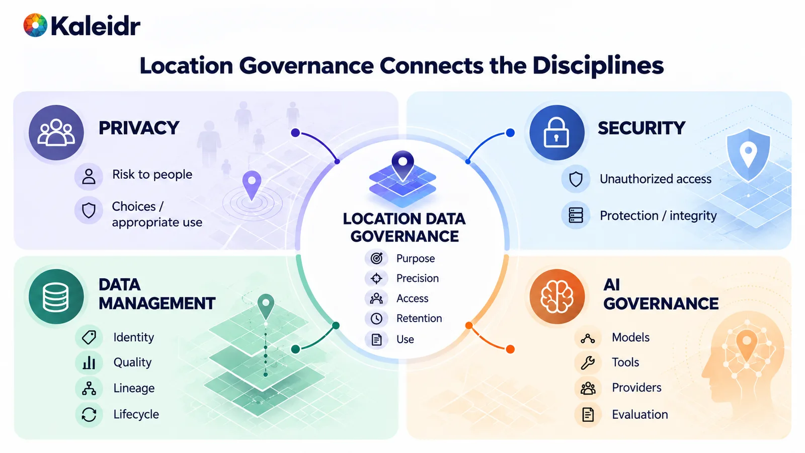
The diagram places location records among privacy, security, data management, and AI governance. Privacy covers risk to people and appropriate use. Security covers unauthorized access and integrity. Data management covers identity, quality, lineage, and lifecycle, while AI governance covers models, tools, providers, and evaluation.
NIST describes the AI Risk Management Framework as intended for voluntary use, to improve the ability to incorporate trustworthiness considerations into the design, development, use, and evaluation of AI products, services, and systems. The same page says the framework was released on January 26, 2023 (NIST, 2023). That framework is not a location-data statute, and it does not choose a precision or a retention window for a map product. Use it as a reminder that model use, providers, and evaluation belong in the same review as collection. The geographic rules still have to be written for the product.
Which Location Facts Need a Class?
Classify the location before deciding who may see it. A public place such as a store, an airport, or a park is not the same record as a private business site, a warehouse, or a restricted facility. A user-provided place, typed or selected, is not the same record as a device coordinate from the browser or a phone. Movement, such as a route or a repeated origin, can reveal a pattern even when each point looks ordinary. An inferred location, such as a likely home market, is a derived claim. Operational state, such as a vehicle, an incident, or inventory by place, is a business fact tied to geography.
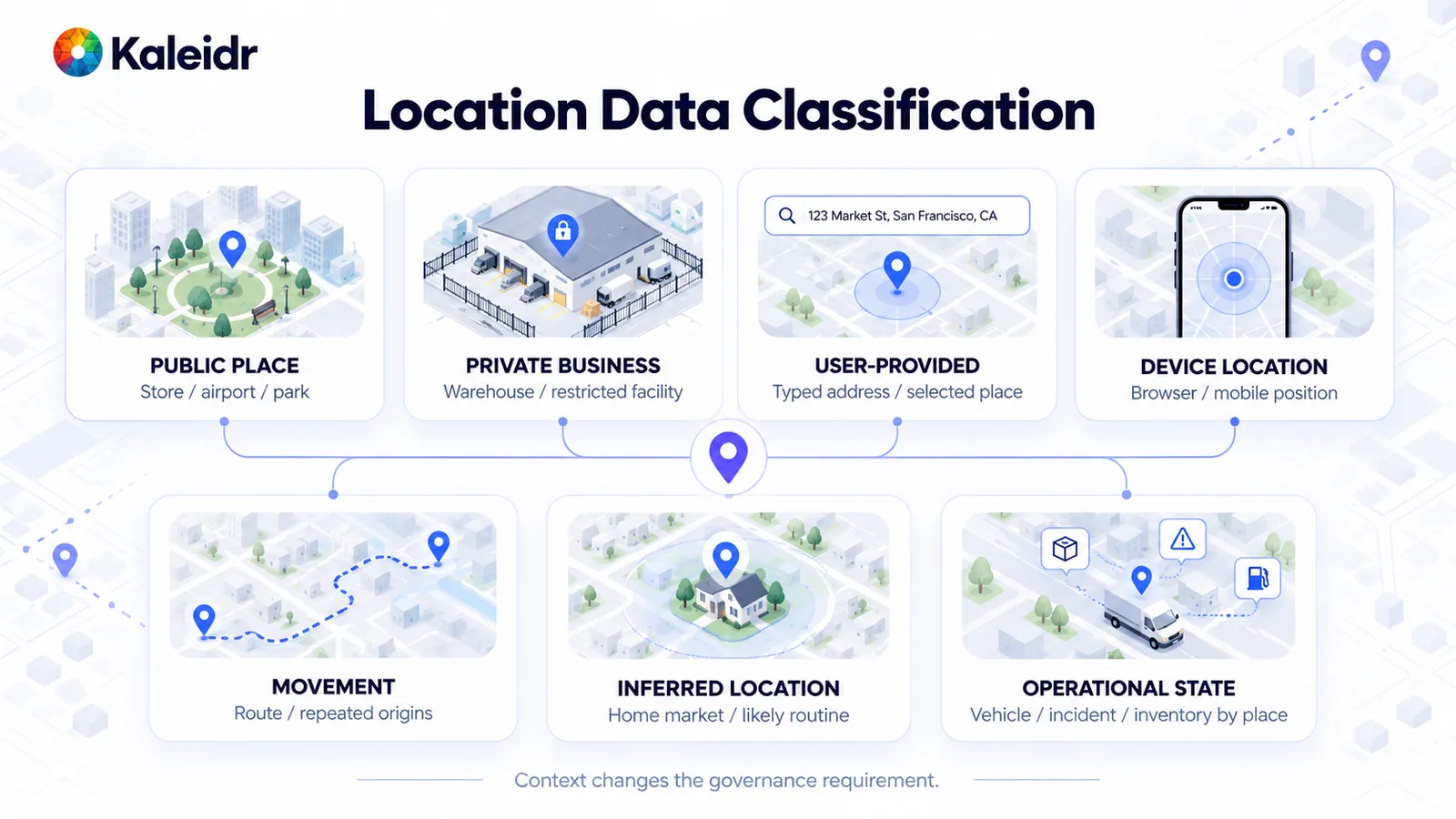
The seven classes are public place, private business, user-provided place, device location, movement, inferred location, and operational state. A park and a warehouse do not carry the same controls. A typed address and a device coordinate do not either. Context changes the requirement, and the sample address on the figure is illustration.
One map can hold several classes at once. A store locator may show a public branch, a user's selected origin, and a private inventory flag in the same answer. Governance should name each field, not stamp one label on the whole screen. Combinations raise sensitivity: a precise coordinate plus a time plus an account can describe a visit that none of the fields describes alone. Do not assign a universal legal label such as personal or non-personal from the class name alone. Jurisdiction, contract, and purpose still decide that question, and this guide is an operating framework rather than a legal opinion.
How Precise Should Each Job Be?
Use the least precise representation that still completes the stated job. A region, a city, or a postal area can support a market view. A neighborhood or a service area can support store selection and route comparison. A place identifier, an address, or an exact coordinate belongs to live operations, fulfillment, or an on-site experience that fails without that detail. Weather, a city-level campaign, or a regional demand chart rarely needs a rooftop. Emergency dispatch and a curbside handoff may. Precision is a control, not a trophy for the most exact sensor available.
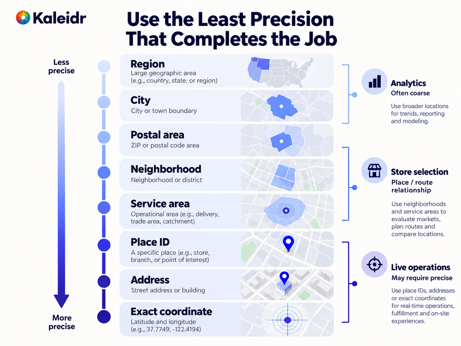
The ladder runs from region and city toward place, address, and exact coordinate. Analytics can often stay coarse. Store selection can use a neighborhood or a service area. Live operations may need a place identifier, an address, or a coordinate, and the sample latitude on the figure is not a Kaleidr result.
A typed address, a selected store, or an active property can complete many jobs without reading the device at all. Keep a canonical place or asset identifier beside any coordinate so a later correction does not depend on matching raw latitude and longitude. The levels on the ladder are not universal sensitivity categories. A city can be sensitive in one context, and a precise coordinate can be appropriate in another, when the purpose, the audience, and the retention are explicit. Drop precision that adds risk and does not change the decision.
Does a Browser Prompt Govern Every Later Use?
A browser geolocation prompt answers a narrow question: may this origin receive the device location? The W3C Geolocation Recommendation of March 24, 2026 calls geolocation a powerful feature that requires express permission before any location data is shared with a web application (W3C, 2026). The recommendation also says recipients ought to request position information only when necessary, and only use that information for the task for which it was provided. Recipients ought to dispose of it once the task is completed, unless the user expressly permits retention, and they need to protect stored location information against unauthorized access. If the information is stored, users need to be allowed to update and delete it, and recipients need to refrain from retransmitting it without the user's express permission.
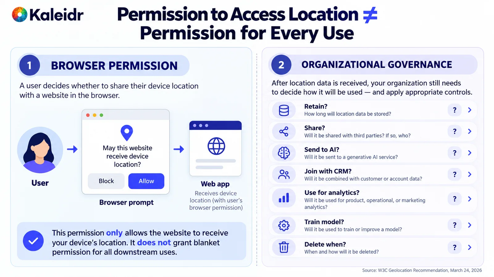
The left side is a browser prompt that lets an origin receive device location. The right side lists later choices about retention, sharing, model use, CRM joins, analytics, training, and deletion. Browser permission does not answer those choices. The source line cites the W3C Geolocation Recommendation of March 24, 2026.
Those platform signals do not decide whether the organization may keep the coordinate for a year, join it to a CRM record, send it to a model provider, use it for advertising, let another employee open it, or train a model on it. Each of those choices needs a product purpose, a contract, and the rules that apply to that deployment. Treat the prompt as one technical gate. The inventory, the retention schedule, and the provider list still have to name the copies that exist after the user taps Allow.
When Does a Precise Location Need Extra Caution?
Precise location becomes more sensitive when it reveals movement or visits tied to personal activity. On May 4, 2026, the Federal Trade Commission said it will prohibit data broker Kochava and its subsidiary from selling, sharing, or disclosing sensitive location data without consumers' affirmative express consent, to settle allegations that the companies sold location data from hundreds of millions of mobile devices that could be used to trace the movements of individuals (FTC, 2026). That action is a data-broker case. Do not read it as a universal rule for every first-party product that centers a map on a store the customer selected.
The caution still belongs in the design review. Ask whether the workflow needs a coordinate, a place identifier, or only a travel time the host already computed. Ask whether a third party may retain the transfer, use it for another purpose, or refuse a later deletion. A derived value such as travel minutes or a route deviation can answer an explanation without shipping the customer's exact origin. Substitution is a control. A policy sentence that says "be careful" is not a control until the payload changes.
What Should a Location Inventory Record?
An inventory names every location field the product actually holds, not the fields a slide deck hoped to collect. For each field, record the class, the purpose, the source system, the canonical identifier, the precision required, the copies that exist, and the owner who can change the rule. Copies include the primary store, a cache, a search index, an export, a prompt, an embedding, an analytics table, and a provider log. A field with no purpose is a candidate for removal. A field with two purposes needs both purposes written down, because a fraud check and a marketing aggregate are not one decision.
Review the inventory when the product changes, not only when a policy document is republished. A new model tool, a new analytics chart, or a new connector can create a copy the last review never saw. Prompts and embeddings are copies of location context even when nobody calls them a database. The integration boundary matters here too. The data-integration guide keeps each operational fact with the system that owns it, and a spatial join of every private record is already a disclosure even when the answer hides some rows (Kaleidr, 2026). Inventory the join, not only the table that looked like the source.
Can a Team Trace a Location From Source to Analytics?
A governed record should be traceable from the input to the map and the aggregate. The path starts with a trusted source, such as a typed address, a device coordinate, or a business master. Normalization resolves those inputs to a canonical place or asset identifier and drops duplicates. A spatial transform then produces the representation the job needs, such as a geocode, a route, or a region. Only after that step should a minimized context, with derived fields rather than the raw origin, reach a model. The map result and the analytics extract come last, and the analytics extract should carry the coarser geography the chart actually needs.
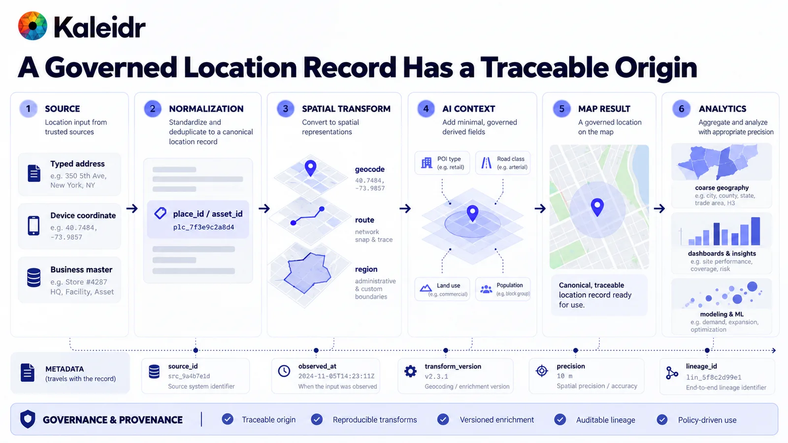
The path runs from a typed address, a device coordinate, or a business master into a canonical place or asset identifier. Spatial transforms then produce a geocode, a route, or a region before a minimized context reaches the map and analytics. Sample identifiers, coordinates, and the precision label on the figure are illustration. A production record should keep source, observation time, transform version, precision, and a lineage identifier.
Carry the metadata with the record: a source identifier, an observation time, a transform version, the precision used, and a lineage identifier. A later correction can then find every derived copy that still depends on the old coordinate. Unknown is a different state from false. A missing observation time is not proof that the place is current. Reproducible transforms and versioned enrichment make an explanation possible. A coordinate that appears in analytics with no source line is a record the team can no longer defend.
Why Must Access Control Happen Before AI Context?
Resolve the user, the tenant, the role, the objects, and the fields before any private spatial record reaches a calculation or a model. The good path filters permitted locations first and runs spatial work only on that set. The blocked path sends an entire private dataset and tries to hide what the user should not see after the model has already received it. Hiding is not authorization. Private-location guidance for AI maps puts the same order in writing: authenticate, authorize, then retrieve a minimized slice, and do not upload an unrestricted internal database (Kaleidr, 2026).
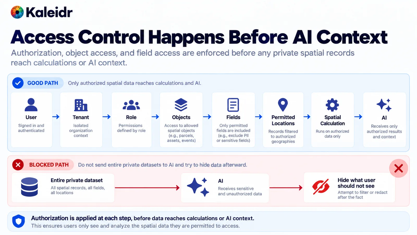
The good path checks user, tenant, role, objects, and fields before any private location reaches a calculation or a model. The blocked path sends an entire private dataset and tries to hide rows afterward. That order is the failure mode. Authorization belongs before retrieval, not after a model has already seen the rows.
A platform credential identifies the integration. An end-user permission identifies which tenant, object, and field that person may use. Those are different checks, and a valid organization key does not grant customer A the right to read customer B's stores, assets, or origins. Caches and retrieval stores need the same tenant boundary as the primary query. Test the cross-tenant failure on purpose. A map that looks correct for one signed-in user can still be leaking the neighbor's records through a shared cache key.
How Long Should Each Location Copy Last?
Retention follows purpose. One global number of days will not fit a request-only origin, a saved place on an account, a vehicle or incident history, and a market-level analytics extract. A request-only coordinate can end when the request ends. An account-linked place can last while the feature or the account is active. Operational state can keep a current value plus a governed history after the event closes, for safety, support, or a contractual record. Analytics can keep a reduced precision, aggregated or de-identified under the analytics policy, for longer than the live coordinate.
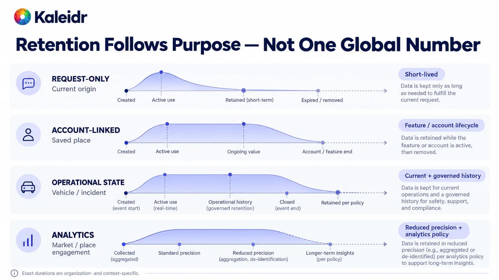
Retention follows the job, not one global number. A request-only origin can expire when the request ends. An account-linked place can last with the feature, and operational state can keep a governed history after the event closes. Analytics can keep a coarser geography for longer, and exact durations stay specific to the organization.
Separate the location the product needs in the moment from the location analytics keeps. A live handoff may need an address. A dashboard of reach, sessions, and place engagement often needs a market, a city, or a trade area. Write that split down so a chart does not quietly store the rooftop that the product used once. Exact durations are organization-specific and context-specific. The figure shows the shape of four lifecycles, not a retention schedule a team can paste into a policy.
What Has to Move When a Location Record Is Deleted?
Deletion is a propagation workflow. A request to delete or revoke a record has to reach the primary store, in-memory and edge caches, search indexes, and vector stores that hold embeddings. Analytics tables, exports, and provider systems need their own handling, which may be deletion, a governed expiry, or a documented detach from the identifier. Observability stores need the same review. Prefer identifiers, versions, counts, and reason codes in telemetry, and keep secrets, raw private records, and unneeded precise coordinates out of that store (Kaleidr, 2026).
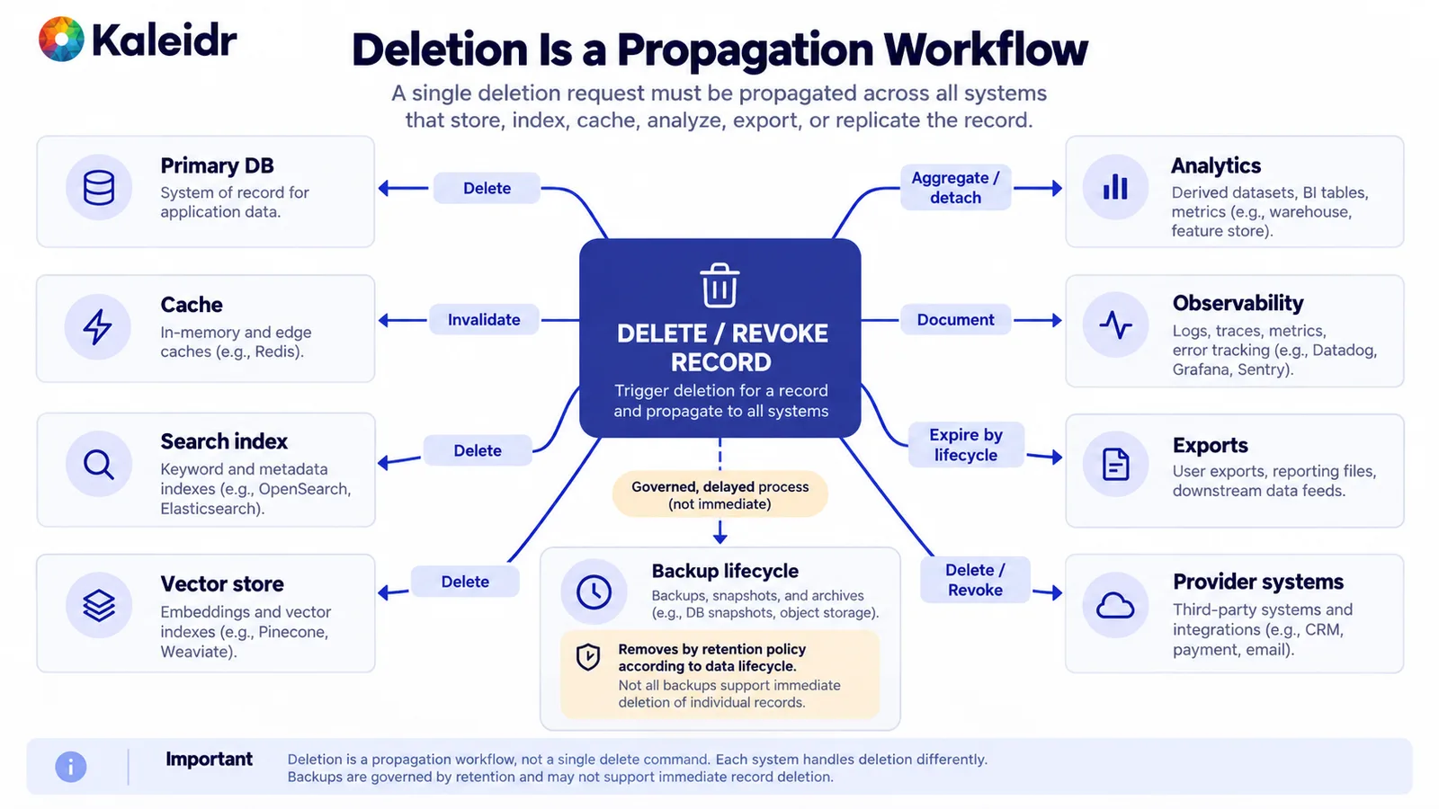
A deletion or revocation has to reach the primary store, caches, search indexes, and vector stores. Analytics, observability, exports, and provider systems need their own handling, which may be deletion, expiry, or a documented detach. Backups follow their retention policy and may not remove one record immediately. The diagram is a propagation map, not a single delete command.
Backups, snapshots, and archives follow the backup lifecycle. Do not claim that every backup can erase one record on demand. Say what the backup policy actually does, including how long a deleted record can remain in a snapshot. Provider contracts belong in the same map: a model or enrichment vendor that retains prompts can keep a location copy after the primary row is gone. Revocation of access is related but not identical. A user who loses a role should stop receiving new records immediately, even when an older aggregate is still inside its analytics window.
Where Should Location Data Governance Sit Beside Kaleidr?
Keep identity, tenant authorization, private business data, CRM, inventory, booking, retention policy, legal and privacy decisions, and transactions inside the host organization. Apply purpose, precision, authorization, minimization, and lineage before any authorized record reaches a Kaleidr surface. Kaleidr Enterprise is location intelligence infrastructure with inference APIs, ranking systems, and analytics built for modern spatial products (Kaleidr, 2026). Developer docs describe Chat as Spatial AI in the host map, Viewer as publishing a map, Tile as designed basemaps, and Editor as draw and edit (Kaleidr, 2026). Viewer embeds a published map by its share id and does not require a publishable key for that embed (Kaleidr, 2026).
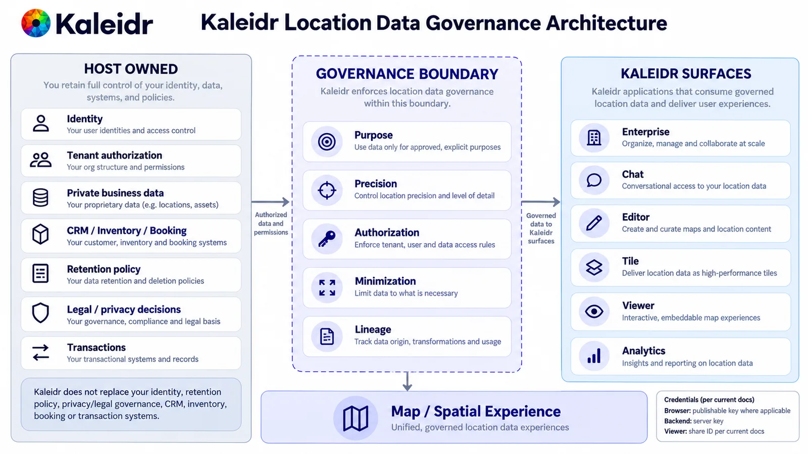
The left column stays with the host: identity, tenant authorization, private business data, CRM, inventory, booking, retention policy, legal and privacy decisions, and transactions. The center lists controls the host applies before any record crosses: purpose, precision, authorization, minimization, and lineage. The right column names documented Kaleidr surfaces: Enterprise, Chat, Editor, Tile, Viewer, and Analytics. Kaleidr does not replace the host systems in the left column.
Docs distinguish a server credential, used from the backend, from a publishable browser credential that the SDK exchanges for a short-lived session and does not send as a raw bearer (Kaleidr, 2026). Neither form is an end-user permission, and a server credential does not belong in browser code. Kaleidr Analytics documents reach, views, and engagement, audience location and activity across maps, and sessions, views, and interactions per map, plus spatial patterns such as clusters, gaps, and routes (Kaleidr, 2026). Decide which of those signals may carry fine location and which should stay coarse in the host warehouse. Confirm contractual retention and processing for the deployment rather than inferring them from this article.
Explore Kaleidr Enterprise to add spatial intelligence beside the systems that already own users and records. Explore Kaleidr Analytics for documented map and place engagement inside the precision the governance review allows. Read both pages against the inventory, and keep any finer location in the host system when the chart does not need it.
Note: Kaleidr uses AI-assisted tools for image creation, content refinement, and research throughout its creative and development workflows.
FAQs
Does a browser location permission authorize every later use?
No. The prompt decides whether an origin may receive device location. Retention, sharing, model use, CRM joins, analytics, training, and deletion remain separate organizational decisions.
Should analytics keep the same precision as the live product?
Not by default. A live task may need a place or an address. A market chart can often keep a city, a trade area, or another coarse geography under its own retention rule.
Does Kaleidr replace a company's location data governance program?
No. Kaleidr provides documented Spatial AI, map, SDK, API, and analytics capabilities. The host organization still owns user permissions, private business systems, classification, retention, and legal or privacy decisions unless a specific contract states otherwise.
What should a deletion request reach?
The primary store, caches, search indexes, vector stores, analytics extracts, exports, telemetry, and provider systems that hold a copy. Backups follow their own lifecycle and may not erase one record immediately.
References
- National Institute of Standards and Technology. AI Risk Management Framework. Intended for voluntary use, to improve trustworthiness considerations in the design, development, use, and evaluation of AI products, services, and systems. Released January 26, 2023. Accessed October 5, 2026. https://www.nist.gov/itl/ai-risk-management-framework
- World Wide Web Consortium. Geolocation. W3C Recommendation, March 24, 2026. Express permission before a web application receives device location, with guidance on necessity, purpose, disposal, protection, update, deletion, retransmission, and disclosure. Accessed October 5, 2026. https://www.w3.org/TR/2026/REC-geolocation-20260324/
- Federal Trade Commission. FTC to Ban Kochava and Subsidiary from Selling Sensitive Location Data. May 4, 2026. Accessed October 5, 2026. https://www.ftc.gov/news-events/news/press-releases/2026/05/ftc-ban-kochava-subsidiary-selling-sensitive-location-data-settle-charges-they-sold-location-data
- Kaleidr. Spatial AI Data Integration. Each operational fact stays with the system that owns it, and a spatial join of private records is already a disclosure. https://kaleidr.com/blog/spatial-ai-data-integration
- Kaleidr. Private Location Data for AI Map Workflows. Authorize before retrieval, and do not upload an unrestricted internal database to a map or a language model. https://kaleidr.com/blog/private-location-data-for-ai-map-workflows
- Kaleidr. Spatial AI Observability. Prefer identifiers, versions, counts, and reason codes, and keep unneeded precise location out of telemetry. https://kaleidr.com/blog/spatial-ai-observability
- Kaleidr. Location Intelligence APIs and Map SDK. Inference APIs, ranking systems, and analytics for spatial products. Accessed October 5, 2026. https://kaleidr.com/enterprise
- Kaleidr Developer Docs. Products. Chat is Spatial AI in the host map, Editor is draw and edit, Tile is designed basemaps, and Viewer publishes a map. Accessed October 5, 2026. https://docs.kaleidr.com/
- Kaleidr Developer Docs. Viewer. Embeds a published map by its share id, and that embed does not require a publishable key. Accessed October 5, 2026. https://docs.kaleidr.com/viewer
- Kaleidr Developer Docs. Auth & Scopes. Distinguishes a backend server credential from a publishable browser credential with a different runtime. Accessed October 5, 2026. https://docs.kaleidr.com/platform-api/auth-and-scopes
- Kaleidr. Map Engagement and Location Analytics. Reach, views, engagement, audience location and activity, sessions, and spatial patterns. Accessed October 5, 2026. https://kaleidr.com/analytics
@misc{nist_ai_rmf_2023,
  title  = {AI Risk Management Framework},
  author = {{National Institute of Standards and Technology}},
  year   = {2023},
  url    = {https://www.nist.gov/itl/ai-risk-management-framework}
}

@misc{w3c_geolocation_2026,
  title  = {Geolocation},
  author = {{World Wide Web Consortium}},
  year   = {2026},
  url    = {https://www.w3.org/TR/2026/REC-geolocation-20260324/}
}

@misc{ftc_kochava_2026,
  title  = {FTC to Ban Kochava and Subsidiary from Selling Sensitive Location Data},
  author = {{Federal Trade Commission}},
  year   = {2026},
  url    = {https://www.ftc.gov/news-events/news/press-releases/2026/05/ftc-ban-kochava-subsidiary-selling-sensitive-location-data-settle-charges-they-sold-location-data}
}

@misc{kaleidr_data_integration_2026,
  title  = {Spatial AI Data Integration},
  author = {{Kaleidr}},
  year   = {2026},
  url    = {https://kaleidr.com/blog/spatial-ai-data-integration}
}

@misc{kaleidr_private_location_2026,
  title  = {Private Location Data for AI Map Workflows},
  author = {{Kaleidr}},
  year   = {2026},
  url    = {https://kaleidr.com/blog/private-location-data-for-ai-map-workflows}
}

@misc{kaleidr_observability_2026,
  title  = {Spatial AI Observability},
  author = {{Kaleidr}},
  year   = {2026},
  url    = {https://kaleidr.com/blog/spatial-ai-observability}
}

@misc{kaleidr_enterprise_governance_2026,
  title  = {Location Intelligence APIs and Map SDK},
  author = {{Kaleidr}},
  year   = {2026},
  url    = {https://kaleidr.com/enterprise}
}

@misc{kaleidr_docs_home_governance_2026,
  title  = {Kaleidr Developer Docs},
  author = {{Kaleidr}},
  year   = {2026},
  url    = {https://docs.kaleidr.com/}
}

@misc{kaleidr_docs_viewer_2026,
  title  = {Viewer},
  author = {{Kaleidr}},
  year   = {2026},
  url    = {https://docs.kaleidr.com/viewer}
}

@misc{kaleidr_auth_scopes_2026,
  title  = {Auth and Scopes},
  author = {{Kaleidr}},
  year   = {2026},
  url    = {https://docs.kaleidr.com/platform-api/auth-and-scopes}
}

@misc{kaleidr_analytics_governance_2026,
  title  = {Map Engagement and Location Analytics},
  author = {{Kaleidr}},
  year   = {2026},
  url    = {https://kaleidr.com/analytics}
}