
Accessible interactive maps let someone complete the same location task by keyboard, assistive technology, or touch, without depending on drag, color, or a pin they must see. Search, a result list, details, and a named answer carry the job. The map stays the visual view of that shared state.
The sections below separate the task from the canvas, then cover place identity, keyboard order, dragging, color, announcements, and AI answers. A reflow exception for the map does not excuse the rest of the page. Kaleidr Studio, Viewer, and Chat sit beside the host controls that make the task operable.
Accessible interactive map essentials
- Name the task: Search, compare, select, and act are the job. The canvas is one view of that job.
- Share one place identifier: The list, the marker, the details, and the AI answer refer to the same record.
- Offer a non-drag path: Pan buttons, a tap target, address entry, and move-up or move-down controls sit beside dragging.
- Do not encode meaning in color alone: Status needs text, shape, or an icon as well as hue.
- Announce the outcome: A result count, a ready route, or an empty match belongs in a status message. Tile loads do not.
What Are Accessible Interactive Maps?
Accessible interactive maps are location experiences in which keyboard, assistive technology, and pointer users can finish the same task. The task might be finding a museum with a step-free entrance, comparing three libraries, or choosing a pharmacy that stays open. The map shows spatial relationships. Search, filters, a result list, details, and a written answer carry the facts a person needs when the canvas is hard to see, drag, or tap. One interface that only works by pointer is a visual map, not an accessible one.
WCAG 2.2 is a W3C Recommendation dated December 12, 2024. The recommendation is the current web standard this guide applies to map tasks, including focus, dragging, target size, color, contrast, and reflow (W3C, 2024). The cover pairs a result list with a map and an answer that names City Museum, a sample distance, and sample amenities. Those distances and amenity labels are illustration. A production card should expose real fields from the place record, and a filter named Accessible is not evidence that a venue was audited.
Why Start With the Task Instead of the Canvas?
A map-only path asks someone to explore the canvas, find a pin, read a popup, and then act. That path requires visual interpretation and pointer precision. An accessible path starts with search or a prompt, then a structured result list, then place details, then an action such as directions, save, or share. The map updates beside those steps and is not the only way through them. Kaleidr's embed guide already asks for headings, summaries, and a location list outside the canvas so the page stays useful for keyboard users, assistive technology, and search (Kaleidr, 2026).
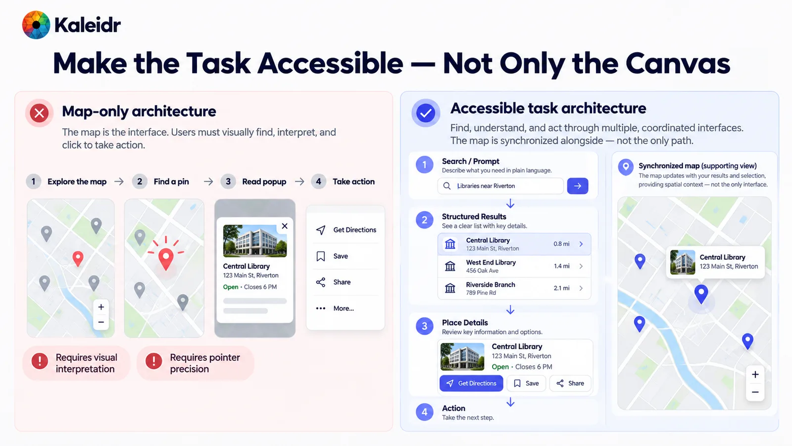
The left path treats the map as the interface and marks visual interpretation and pointer precision as requirements. The right path runs search, a result list, details, and an action, with the map as a supporting view. Sample library names, addresses, and distances are illustration. The split is an architecture choice, not a Kaleidr score.
Put the essential record in HTML. A name, an address, a category, hours, and the next action should exist even when the map tiles fail. The popup can repeat those facts. The popup cannot be the only copy. Stable place identifiers, covered next, keep the list row and the marker tied to that same record.
Why Does One Place Identifier Matter?
Search, the result card, the detail panel, the map marker, the AI answer, and an analytics event should share one place identifier. When the identifier changes meaning between surfaces, a keyboard user can select FreshMart in the list while the map highlights a different store and the answer describes a third. The figure centers that identifier and fans it out to each surface. Sample street addresses, a star rating, a review count, a phone number, coordinates, and the timestamp on the figure are illustration, not a live Kaleidr record.
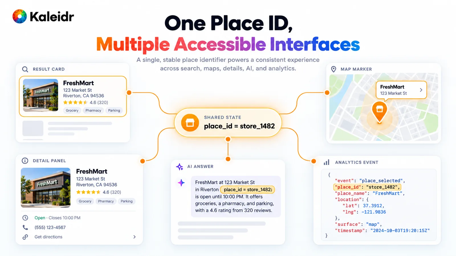
A shared place identifier feeds the result card, the detail panel, the marker, the answer, and the analytics event. Each surface shows the same name and address. The rating, phone number, coordinates, and event time on the figure are samples. Production analytics should keep the identifier and avoid copying fields the event does not need.
Selection follows the identifier, not a screen coordinate. Activating a list row sets the selected place, moves the map, and updates details without asking the person to hunt for the pin. A marker click does the reverse and highlights the same row. Do not move keyboard focus to the map on every selection, or a screen-reader user loses their place in the list. Focus and selection are different states, and the next section keeps them apart.
What Keyboard Order Completes the Task?
Design focus order around the task. A workable sequence is search, filters, a result summary, the result list, map controls, details, and the primary action. The person can understand the count, choose a place from the list, pan or zoom if they want the map, read details, and then get directions. Map markers do not each need a tab stop when the list already exposes the same places. Arrow keys can move inside the list. Tab moves between the larger regions.
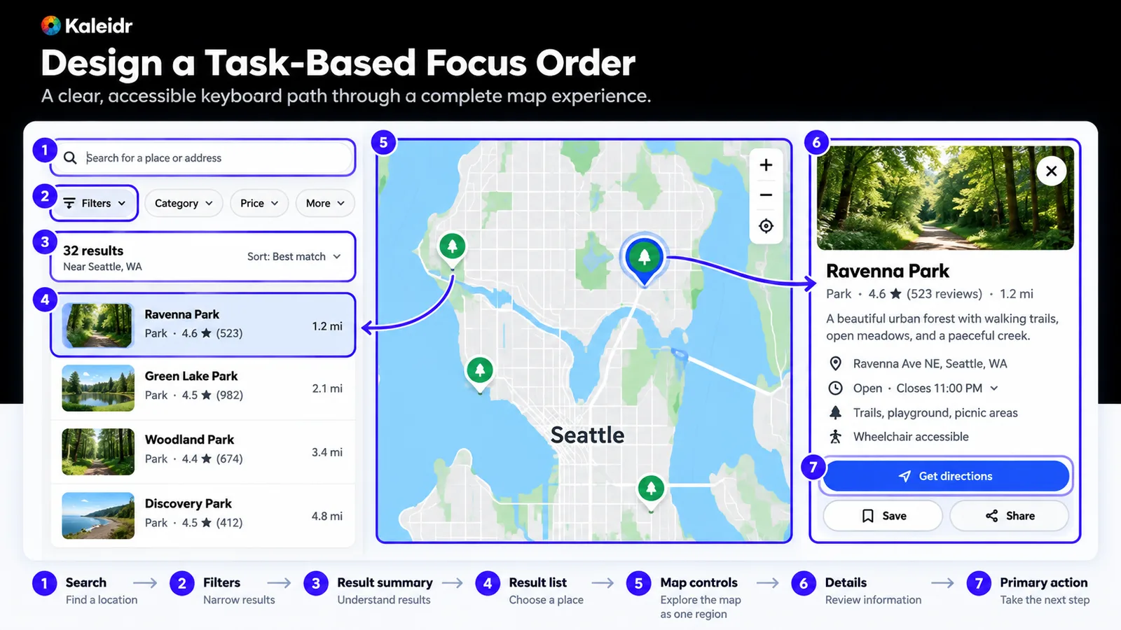
The path runs from search to filters, a result summary, the list, map controls, details, and the primary action. A selected park stays tied to its list row and its detail card. The result count and the sample distances are illustration. Focus order follows the task, and the map is one stop rather than a field of pins.
Author-created content that entirely hides a focused control, such as a sticky search bar or a chat panel, fails Success Criterion 2.4.11 (AA) in WCAG 2.2. Note 2 of that criterion allows content the user opened, such as a details drawer, to obscure the control when the person can reveal it without advancing keyboard focus. Partial covering, where some of the control remains visible, is Success Criterion 2.4.12 (AAA). Visible focus and visible selection need different styles, because a blue list row and a focus ring answer different questions. WAI-ARIA keyboard guidance tells authors to distinguish focus from selection, especially when selected items sit in a component that does not hold focus (W3C, 2026). Keep a focus ring on the control that will receive the next key, and a separate selected treatment on the place.
Why Can't Dragging Be the Only Path?
Maps invite dragging, and dragging cannot be the only way to pan, set a stop, or reorder a route. Success Criterion 2.5.7 in WCAG 2.2 says functionality that uses a dragging movement can be achieved by a single pointer without dragging, unless dragging is essential or the user agent determines the behavior and the author has not modified it. A keyboard alternative does not, by itself, meet that pointer requirement. Offer directional pan buttons, a tap that sets the destination, an address field, and move-up or move-down controls for ordered stops. Success Criterion 2.5.8 in the same recommendation sets a minimum target size of 24 by 24 CSS pixels, with exceptions that include spacing and an equivalent control elsewhere on the page.
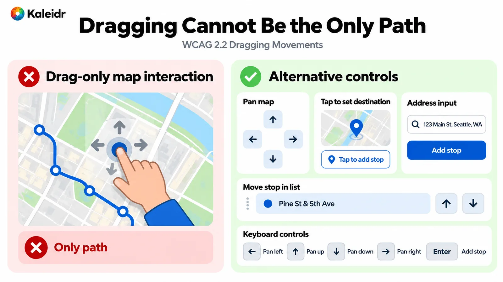
The left panel shows dragging as the only way to move the map. The right panel adds pan buttons, a tap target, an address field, reorder buttons, and keyboard pan keys. The sample address is illustration. A keyboard path remains necessary, and it does not replace the single-pointer alternative to dragging.
Leave the map without trapping the keyboard. If arrow keys pan while focus is on the map, Escape or a documented key should return focus to the list or the next control. Zoom, locate, and close need accessible names, not icon-only buttons that a screen reader cannot label. Target size matters on those controls and on list rows, where a tiny hit area fails people who tap or who use a pointer with less precision.
Why Is Color Not Enough on a Map?
Success Criterion 1.4.1 says color cannot be the only visual means of conveying information, indicating an action, prompting a response, or distinguishing an element. A green dot for open and a red dot for closed fails when the hue is the only difference. Pair the color with a label, a check, a cross, or another shape. The same rule covers category markers, selected routes, and "you are here." Success Criterion 1.4.11 in the same recommendation also asks for a contrast ratio of at least 3:1 for the visual information required to identify user interface components and states, except inactive components or components whose appearance the user agent determines. A white zoom button on a pale basemap can miss that ratio even when the brand colors look fine on a white page.
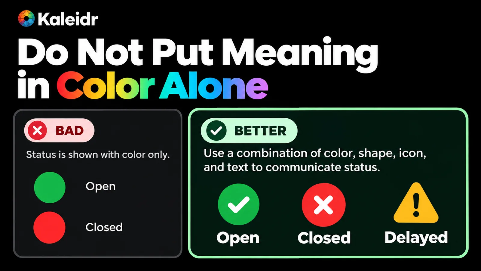
The weak example uses a green circle for open and a red circle for closed. The stronger example adds a check, a cross, a warning shape, and the words Open, Closed, and Delayed. Color still helps. Text and shape carry the meaning when color cannot be seen.
Legends belong in text, not only in a colored key painted on the map. A category filter should state its selected state in the control name or an adjacent label. Do not tell a person to "follow the red pin" in the interface copy. Name the place. The AI section below applies that rule to generated answers.
What Should Assistive Technology Hear?
Announce the outcome of an action, not the renderer. A useful status says that four stores match the filters, that a route is ready and how long it takes, or that no accessible entrances match. Tile loaded, marker moved, and map center changed are noise. A live region wrapped around the whole map will read those technical events and bury the sentence the person needed. WAI documents a technique, ARIA22, for using role=status to present status messages. The technique is an example of a way to meet WCAG, not a requirement that every map use that exact role (W3C, 2026).
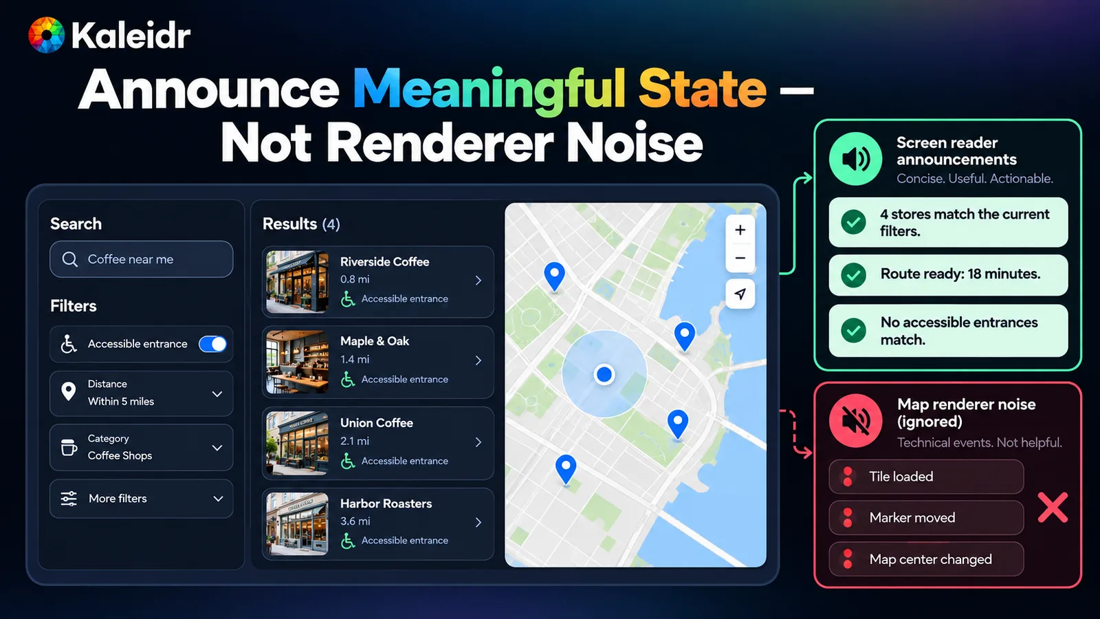
The useful channel reports a result count, a ready route, and an empty accessible-entrance match. The ignored channel lists tile loads, marker moves, and map-center changes. Sample store names, distances, and the 18-minute route are illustration. Announce the state the person can act on.
Search and filters need the same discipline. After a query, report the count or the empty state once, not a stream of marker updates. Keep the announcement short enough to interrupt politely. Do not move focus into the map when the count changes. The list remains the place where the person reads the matches, and the map reflects the same set.
Why Must the AI Answer Name the Place?
An AI map answer has to stand on its own in text. "Downtown Pharmacy is open until midnight and is 1.2 miles from your selected origin" names the place, the hours, and the distance. "I highlighted the red pin" points at the canvas and fails anyone who cannot see that pin. The map may select the same place and draw a route. The sentence still has to carry the decision. Stream the finished answer, or a short summary, into the status channel. Do not send every token to assistive technology, and do not pull focus into the chat on each fragment.
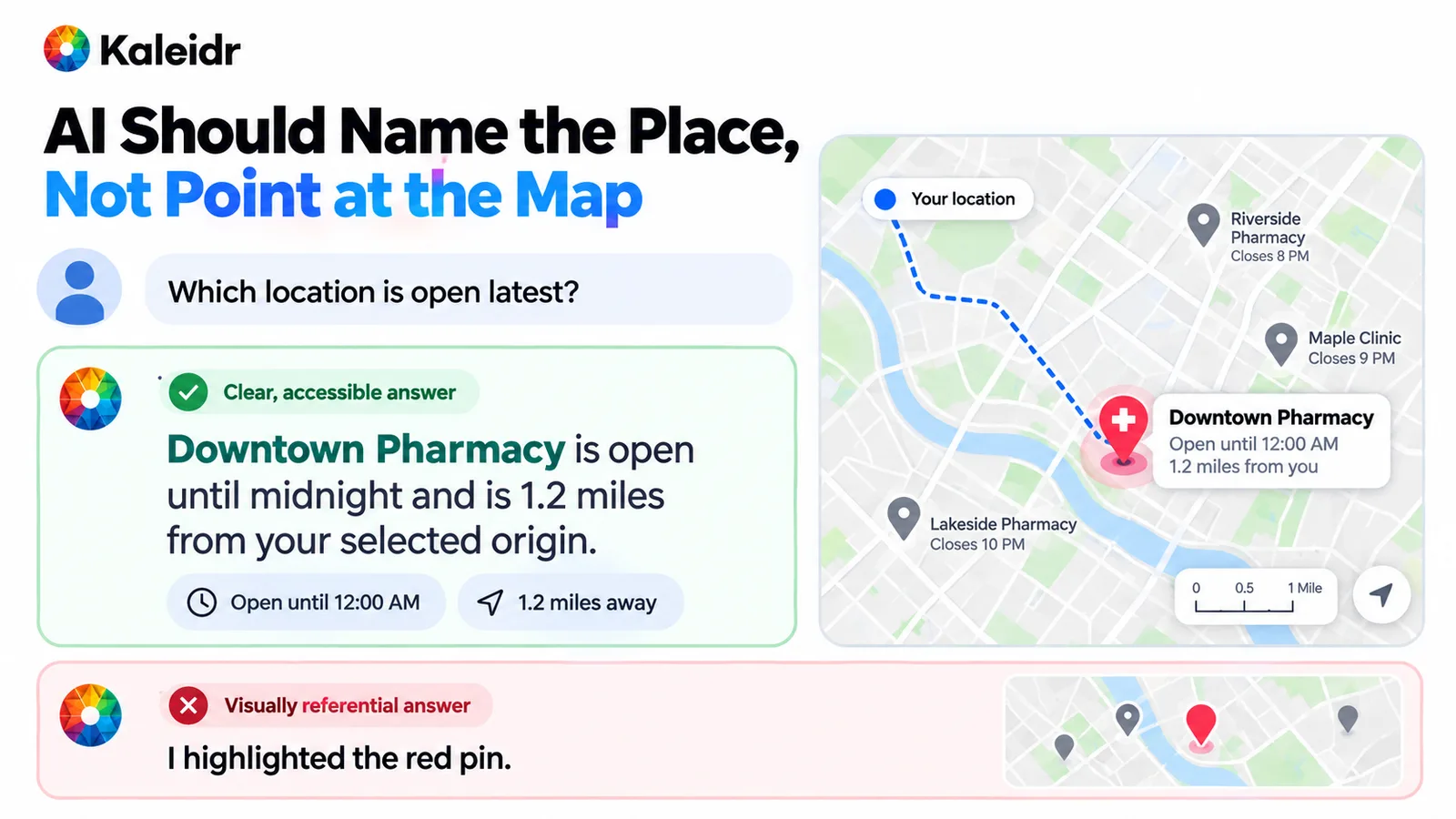
The useful answer names Downtown Pharmacy, closing time, and distance from a selected origin. The map shows that place and a route. The rejected answer only says a red pin was highlighted. The pharmacy name, the hours, and the distance on the figure are illustration.
Keep the model off the access decision. The host authorizes the records, and the answer may describe only places already in the result set. Do not let generated text invent a step-free entrance, an accessible toilet, or a certification the source data does not contain. If the record lacks an accessibility field, the answer should say the field is unknown. A highlight on the map is optional confirmation, not the content of the reply.
What Still Works When the Map Cannot Reflow?
Success Criterion 1.4.10 in WCAG 2.2 treats some content as requiring two-dimensional layout for use or meaning. Note 2 lists images required for understanding, such as maps and diagrams, and accepts two-dimensional scrolling for those parts. The exception covers the map. The exception does not cover the page heading, search, filters, result text, buttons, the AI answer, or the detail card. At a narrow width or a high zoom, stack the list above or below the map, keep the map in its own scrollable region, and leave the text outside that region. The person should still complete the task when the canvas is a small pane.
Failure needs the same split. If tiles do not load, the result list, details, and primary action remain. Say that the map did not load, and keep the records available. A blank canvas with no text is a broken task, not a styling problem. Reduced motion belongs here too. Do not rely on a long fly-to animation to communicate which place was selected. Move the selection and update the list even when the camera move is shortened or skipped.
Where Should Accessible Interactive Maps Sit Beside Kaleidr?
Keep search, filters, the result list, details, primary actions, and status messages on the host page. Share place, route, selection, filter, and result-set identifiers with the map. Kaleidr Studio is where teams turn ideas into interactive maps with locations, content, and behavior (Kaleidr, 2026). Viewer embeds a published map by its share id and does not require a publishable key for that embed (Kaleidr, 2026). Developer docs describe Chat as Spatial AI in the host map, Viewer as publishing a map, Tile as designed basemaps, and Editor as draw and edit (Kaleidr, 2026). The host still owns the accessible path around those surfaces.
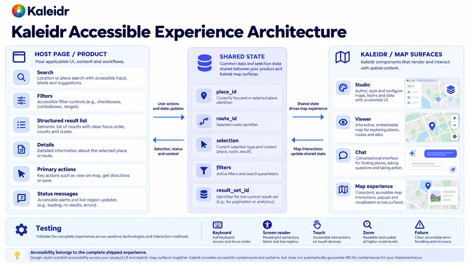
The host page owns search, filters, the result list, details, actions, and status messages. Shared identifiers connect that page to Studio, Viewer, Chat, and the map. The footer of the figure says Kaleidr does not automatically guarantee WCAG conformance. Testing the shipped experience remains the publisher's job.
A template or a map component can supply a foundation. The no-code launch guide says a template cannot guarantee conformance once a publisher adds colors, content, and map behavior, because conformance belongs to what shipped (Kaleidr, 2026). Test the full task with a keyboard, a screen reader, zoom, and a narrow viewport. Include a failure case where the map does not load. This article is an implementation guide, not a conformance audit and not legal advice.
Explore Kaleidr Studio to design and publish the map. Read the developer docs for the documented Chat, Viewer, Tile, and Editor surfaces. Keep the result list and the named answer on the host page, tied to the same place identifier the map uses.
Note: Kaleidr uses AI-assisted tools for image creation, content refinement, and research throughout its creative and development workflows.
FAQs
Does a keyboard alternative replace a non-drag pointer path?
No. WCAG 2.2 asks for a single-pointer way to complete a dragging action, unless dragging is essential or the user agent determines it. Keyboard access is a separate requirement for the same task.
Does the map's reflow exception cover search and the result list?
No. Maps and diagrams may keep two-dimensional scrolling. Headings, search, filters, results, buttons, and the AI answer still need to remain usable when the page is narrow or zoomed.
Does Kaleidr guarantee WCAG conformance for a published map?
No. Studio, Viewer, and Chat are product surfaces. Conformance depends on the shipped page, including labels, contrast, the result list, status messages, and testing.
Should an AI map answer say "the red pin"?
No. Name the place, the relevant status, and the distance or route in text. The map can select that same place. The sentence has to stand without the canvas.
References
- World Wide Web Consortium. Web Content Accessibility Guidelines (WCAG) 2.2. W3C Recommendation, December 12, 2024. Includes 2.4.11 Focus Not Obscured (Minimum), 2.4.12 Focus Not Obscured (Enhanced), 2.5.7 Dragging Movements, 2.5.8 Target Size (Minimum), 1.4.1 Use of Color, 1.4.11 Non-text Contrast, and the 1.4.10 Reflow note that lists maps and diagrams. Accessed October 7, 2026. https://www.w3.org/TR/WCAG22/
- Kaleidr. Embed Interactive Map on a Website. Asks for headings, summaries, and a location list outside the canvas. https://kaleidr.com/blog/how-to-embed-interactive-map-on-a-website
- W3C Web Accessibility Initiative. Developing a Keyboard Interface. Distinguishes keyboard focus from selection. Accessed October 7, 2026. https://www.w3.org/WAI/ARIA/apg/practices/keyboard-interface/
- W3C Web Accessibility Initiative. ARIA22: Using role=status to present status messages. An example technique, not a required implementation. Accessed October 7, 2026. https://www.w3.org/WAI/WCAG22/Techniques/aria/ARIA22
- Kaleidr. AI Map Maker for Branded Interactive Maps. Studio turns ideas into interactive maps with locations, content, and behavior. Accessed October 7, 2026. https://kaleidr.com/studio
- Kaleidr Developer Docs. Viewer. Embeds a published map by its share id, and that embed does not require a publishable key. Accessed October 7, 2026. https://docs.kaleidr.com/viewer
- Kaleidr Developer Docs. Introduction. Chat is Spatial AI in the host map, Editor is draw and edit, Tile is designed basemaps, and Viewer publishes a map. Accessed October 7, 2026. https://docs.kaleidr.com/
- Kaleidr. Launch a No-Code Map Website. A template does not guarantee conformance of the experience a publisher ships. https://kaleidr.com/blog/launch-a-map-website-no-code
@misc{w3c_wcag22_2024,
  title  = {Web Content Accessibility Guidelines (WCAG) 2.2},
  author = {{World Wide Web Consortium}},
  year   = {2024},
  url    = {https://www.w3.org/TR/WCAG22/}
}

@misc{kaleidr_embed_map_2026,
  title  = {Embed Interactive Map on a Website},
  author = {{Kaleidr}},
  year   = {2026},
  url    = {https://kaleidr.com/blog/how-to-embed-interactive-map-on-a-website}
}

@misc{w3c_keyboard_interface_2026,
  title  = {Developing a Keyboard Interface},
  author = {{World Wide Web Consortium}},
  year   = {2026},
  url    = {https://www.w3.org/WAI/ARIA/apg/practices/keyboard-interface/}
}

@misc{w3c_aria22_2026,
  title  = {ARIA22: Using role=status to present status messages},
  author = {{World Wide Web Consortium}},
  year   = {2026},
  url    = {https://www.w3.org/WAI/WCAG22/Techniques/aria/ARIA22}
}

@misc{kaleidr_studio_a11y_2026,
  title  = {AI Map Maker for Branded Interactive Maps},
  author = {{Kaleidr}},
  year   = {2026},
  url    = {https://kaleidr.com/studio}
}

@misc{kaleidr_docs_viewer_a11y_2026,
  title  = {Viewer},
  author = {{Kaleidr}},
  year   = {2026},
  url    = {https://docs.kaleidr.com/viewer}
}

@misc{kaleidr_docs_home_a11y_2026,
  title  = {Introduction},
  author = {{Kaleidr}},
  year   = {2026},
  url    = {https://docs.kaleidr.com/}
}

@misc{kaleidr_launch_map_2026,
  title  = {Launch a No-Code Map Website},
  author = {{Kaleidr}},
  year   = {2026},
  url    = {https://kaleidr.com/blog/launch-a-map-website-no-code}
}