
Un mapa mundial de viajes con pines convierte países, ciudades y lugares memorables en un registro interactivo que puedes explorar, actualizar y compartir. Define qué representa cada pin, organiza un conjunto de datos coherente, verifica las coordenadas y diseña un sistema claro para los lugares visitados, planificados y favoritos. Kaleidr Studio puede transformar esa estructura en un mapa interactivo personalizado; después, Viewer o la plantilla de hostelería permiten incorporarlo a un sitio web.
Las siguientes secciones abarcan el propósito, el alcance, los datos, el diseño de pines, la creación y el perfeccionamiento en Studio, las rutas, las preguntas con IA, las opciones de sitio web e inserción, las fotos, la privacidad, la accesibilidad, la medición, los errores habituales y la lista de publicación. Síguelas en orden para completar todo el proceso o pasa directamente a Studio y Viewer si los datos ya están limpios.
Aspectos esenciales de un mapa de viajes
- Define primero el objetivo: Un historial personal, un diario de viaje, un plan futuro, una guía pública y un sitio de destino requieren datos y diseños distintos.
- Usa registros de lugares estables: El ID, el nombre, la ciudad, el país, las coordenadas, el estado, el viaje y una nota breve facilitan el mantenimiento.
- Verifica antes de publicar: El orden de las coordenadas, los nombres ambiguos, los duplicados y el estado actual del lugar importan más que el acabado visual.
- Separa las capas privadas y públicas: El alojamiento actual, las rutas en directo y los datos de reserva no deben publicarse por accidente.
- Publica con un propósito: Comparte un mapa de Studio, inserta Viewer o conecta una plantilla de hostelería cuando la experiencia necesite un sitio completo.
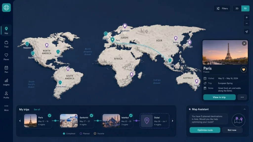
¿Qué es un mapa mundial de viajes con pines?
Un mapa de viaje con alfileres es un mapa mundial, regional o de la ciudad que marca lugares conectados a un viaje o historia de viaje. Los pines pueden representar países visitados, ciudades visitadas, atracciones individuales o alojamiento, destinos futuros, lugares favoritos, rutas de viaje, recomendaciones para otros viajeros o notas personales y medios de comunicación. Un mapa de pin físico registra el viaje sobre una superficie impresa. Un mapa de viaje digital puede agregar búsqueda, categorías, rutas, enlaces, notas, filtros, compartir e incrustar sitios web.
Buscar la intención alrededor del mapa del mundo de viajes con pines, mapa de lugares visitados, mapa de países visitados interactivos, mapa de ciudades visitadas y mapa de viajes digital generalmente apunta a una necesidad de producto: un mapa real que la gente puede construir y usar, no solo un artículo que describe mapas de viaje.
¿Para qué debe servir el mapa?
El propósito del mapa determina sus datos, el diseño y el método de publicación. Un mapa personal de los países visitados necesita una amplia cobertura y colores de estado simples. Una guía de destino necesita lugares individuales precisos, descripciones más sólidas y un flujo de trabajo de publicación claro. Mezclar ambos propósitos en un mapa generalmente crea desorden innecesario.
| Objetivo de mapa | Unidad geográfica recomendada | Contenido útil |
|---|---|---|
| Historia personal de viajes | Países y ciudades | Año de visita, nombre de viaje, estado favorito |
| Diario de viaje | Lugares individuales | Fecha, nota, enlace fotográfico, categoría de memoria |
| Plan de viaje futuro | Ciudades y atracciones | Prioridad, estado, nota de presupuesto, ventana de viaje |
| Guía de viaje pública | Lugares curados | Descripción, categoría, fuente, direcciones |
| Sitio web de destino | Lugares de interés y rutas | Lugares Detalles, itinerarios, preguntas de IA, compartir |
| Viaje en equipo o en grupo | Lugares y asignaciones | Propietario, estado, enlace de reserva, punto de encuentro |
¿Cómo elegir el alcance adecuado?
Utilice un mapa del mundo cuando la pregunta principal es a dónde ha viajado; los pines a nivel de país o de ciudad funcionan bien a esa escala. Utilice un mapa regional cuando el usuario necesite comparar ciudades, rutas y patrones de viaje dentro de un país o viaje multinacional. Utilice un mapa de la ciudad cuando los lugares individuales sean importantes: restaurantes, museos, hoteles, parques, miradores y paradas de tránsito se vuelven legibles a esa escala. Un mapa multiescala comienza con una vista global y revela más detalles a medida que el usuario hace zoom. Ese enfoque funciona bien para los historiales de viajes largos, pero requiere una cuidadosa densidad de marcadores, agrupación y jerarquía de etiquetas.
¿Cómo crear un conjunto de datos de viaje limpio?
Un mapa es más fácil de mantener cuando cada lugar sigue una estructura de registro. Los campos recomendados incluyen un ID de lugar estable, un nombre de lugar legible, ciudad y país, latitud y longitud, estado como visitado, planificado o favorito, categoría, nombre de viaje o colección, fecha de visita, una nota corta y una fuente opcional o enlace de detalle. Utilice identificadores estables incluso para un mapa personal. Los nombres cambian, los nombres duplicados de lugares existen y varios viajes pueden incluir la misma ciudad.
place_id,name,city,country,latitude,longitude,status,category,trip,visit_date,note,url
p001,Louvre Museum,Paris,France,48.8606,2.3376,visited,museum,Paris 2025,2025-05-12,Afternoon visit,https://example.com/louvre
p002,Shibuya Crossing,Tokyo,Japan,35.6595,139.7005,planned,landmark,Japan 2027,,,https://example.com/shibuya
p003,Blue Lagoon,Grindavik,Iceland,63.8804,-22.4495,favorite,wellness,Iceland 2024,2024-09-03,Early morning booking,https://example.com/blue-lagoon
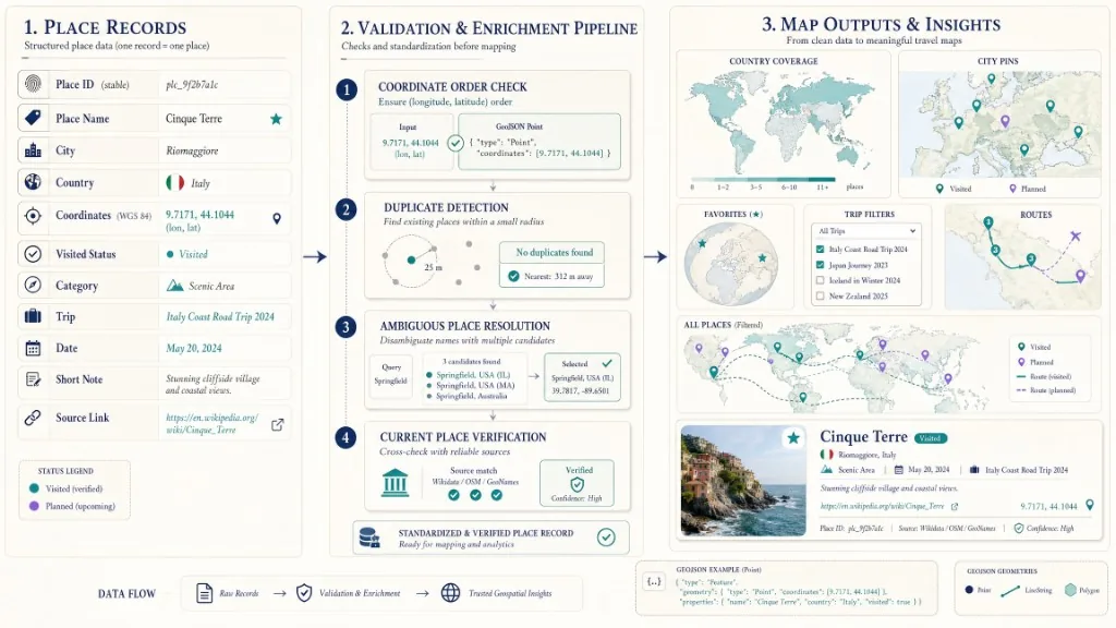
Verifica las coordenadas antes de publicar
Un pin en el país equivocado es fácil de notar. Un pin a una cuadra de distancia puede ser más engañoso porque parece plausible. Antes de publicar, confirme el orden de coordenadas, resuelva nombres de lugares ambiguos, verifique que la ciudad y el país coincidan con las coordenadas, elimine los registros duplicados, verifique que las empresas movidas o renombradas estén actualizadas, distinga un centroide de la ciudad de la entrada real del lugar y preserve la fuente utilizada para verificar la ubicación.
GeoJSON y muchos sistemas de mapeo web utilizan longitud primero y latitud segundo. Por lo tanto, el punto para París aparecería como `[2.3522, 48.8566]], no como lo contrario.¿Ves RFC 7946: El formato GeoJSON.
¿Cómo diseñar un sistema de pines útil?
Un mapa de viaje no debe asignar un icono y color únicos a cada ubicación. El usuario necesita un lenguaje visual pequeño y repetible. Un modelo de estado simple a menudo es suficiente: pin lleno para visitado, pin delineado para el pin planificado, enfatizado o estrella para favorito, y un pin apagado para destinos aún en consideración. Utilice las diferencias de categoría solo cuando soporte la tarea. Un itinerario por la ciudad puede distinguir la comida, la cultura, la naturaleza, el alojamiento y el transporte. Una historia mundial de viajes puede no necesitar categorías en absoluto.
Combine el color con la forma del icono, el estilo del borde, el texto o las etiquetas accesibles para que los usuarios puedan identificar un lugar visitado sin depender completamente del tono. Cuando un usuario abre un lugar, el pin seleccionado debe verse diferente del resto, y el panel de detalles, el pin y cualquier elemento de lista deben permanecer sincronizados.
¿Cómo crear el mapa en Kaleidr Studio?
Kaleidr Studio está diseñado en torno a Prompt, Process, Refin, and Deploy: describir el concepto de mapa, generar y organizar la estructura espacial, ajustar el diseño, el contenido, el estilo y la interacción, y luego publicar el mapa interactivo en plataformas digitales. Kaleidr describe a Studio como un entorno de mapa interactivo personalizado con mosaicos personalizados, visualización 3D, capas de datos en vivo, capas reutilizables, conjuntos de datos y estilo flexible. Utilice solo las capacidades disponibles en su cuenta y verifique los datos importados antes de publicar. Véase Kaleidr Studio.
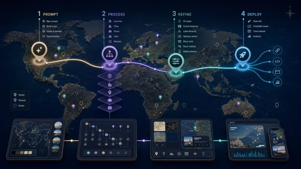
Una solicitud de inicio útil es:
Create an interactive world travel map for my visited and planned destinations.

Map structure:
- Show visited countries and cities.
- Show planned destinations separately.
- Group individual places by trip.

Visual direction:
- Use a warm off-white basemap.
- Use teal for visited places.
- Use violet outlines for planned places.
- Keep country and city labels readable.

Interaction:
- Open a concise place card when a pin is selected.
- Let viewers distinguish visited, planned, and favorite places.
- Start with a world view and reveal place detail when zooming in.

Primary goal:
Create a personal travel history that I can publish and share.
El aviso debe definir la estructura, no reemplazar la revisión. Después del primer borrador, verifique cada ubicación, elimine el contenido irrelevante, simplifique el sistema visual y establezca una cámara de apertura intencional. Para una explicación más amplia de la creación basada en avisos, véase AI Interactive Map Builder: ¿Pronto publicar.
¿Cómo perfeccionar el mapa antes de publicarlo?
La primera vista debe explicar el mapa inmediatamente. Utilice una extensión global para una historia de viajes mundiales, una extensión regional para un viaje o una extensión de ciudad para un itinerario o guía local. Evite abrirse tan lejos que los pasadores se superponen en un cúmulo ilegible. Para un gran historial de viajes, agrupar pines cercanos, revelar lugares detallados en niveles de zoom más cercanos, usar resúmenes de país o ciudad en zooms más amplios, ocultar categorías secundarias hasta que se vuelvan útiles y evitar mostrar cada etiqueta simultáneamente.
Una tarjeta de lugar debe responder lo que es el lugar y por qué es importante. Una o dos oraciones útiles generalmente superan a un largo diario de viaje dentro de un pequeño panel de mapa. Una nota personal puede ser subjetiva. Las reclamaciones de hecho, como los horarios de apertura, la accesibilidad, las direcciones o el estado operativo actual, deben provenir de una fuente de corriente apropiada. Utilice colores, tipografía, etiquetas e iconos de manera consistente. Un mapa base personalizado puede hacer que una guía de viaje pública se sienta parte del sitio circundante en lugar de una incrustación genérica.¿Ves Cómo crear un mapa base de marca personalizado.
¿Cómo añadir rutas sin sobrecargar el mapa?
Las rutas de viaje pueden revelar secuencia y movimiento, pero demasiadas líneas oscurecen rápidamente los lugares. Utilice rutas cuando respondan a una pregunta específica: el camino de un viaje por carretera, el orden de un recorrido a pie por la ciudad, la progresión de un itinerario multi-ciudad, o la conexión entre los centros de transporte y los destinos. Evite trazar una línea directa entre cada ciudad que se haya visitado. Un historial de viaje personal suele ser más fácil de leer cuando las rutas se agrupan por viaje y se pueden mostrar u ocultar. Vínculas de ruta también deben evitar implicar precisión en el transporte a menos que se calculen a partir de un servicio de enrutamiento aprobado. Una línea decorativa entre ciudades no es lo mismo que una carretera, ferrocarril, vuelo o ruta a pie.
¿Cómo añadir preguntas sobre lugares con IA?
Kaleidr posiciona su plantilla de hostelería en torno a destinos seleccionados y viajes en un mapa base diseñado, incluidos los resúmenes de lugares que los espectadores pueden pedir desde el mapa. El producto de chat de Kaleidr también puede adjuntarse a un mapa compatible existente y proporcionar respuestas y navegación de lugar conscientes del mapa. Véase Kaleidr Spatial AI. Las preguntas útiles incluyen qué lugares guardados están cerca del paseo marítimo, qué museos pertenecen a un viaje específico, qué destinos planificados están cerca de una estación de tren, un resumen de los lugares de un viaje o qué explorar cerca de un hotel seleccionado.
La capa de IA debe interpretar la solicitud y coordinar las acciones de mapa soportadas. El asistente de mapa de IA no debe inventar lugares visitados, fechas de viaje, reservas, horarios de apertura o recuerdos personales. Para el patrón de integración técnica, véase Cómo agregar un chat de IA a Mapbox, Google Maps o MapLibre.
¿Cómo convertir el mapa en un sitio web de viajes?
El sistema de plantilla de sitio web de Kaleidr incluye un punto de partida de hospitalidad para destinos y viajes seleccionados. El personalizador del navegador puede conectar un mapa de estudio publicado, habilitar el chat de IA, vincular Kaleidr Analytics, guardar el sitio, publicarlo o descargar el proyecto para su posterior desarrollo. La ruta de la plantilla es apropiada cuando el mapa de viaje necesita páginas circundantes, navegación, estilo de marca y una experiencia de destino más completa.
Un flujo de trabajo práctico es construir y verificar el mapa de viaje en Studio, publicar el mapa y obtener su ID de mapa o la ruta de inserción, abrir el Plantilla de hospitalidad Kaleidr, conecte el mapa publicado, personalice la apariencia y el contenido, habilite el chat de IA solo cuando admita una tarea real de visitante, conecte Analytics, previsualice diseños de escritorio y móviles, luego publique o descargue el proyecto. Para una lista de verificación de producción más amplia, véase Lanzar un sitio web de mapa sin código.
¿Cómo insertar el mapa de viajes en un sitio existente?
Un mapa de Kaleidr Studio publicado se puede incrustar mediante el ID de compartir a través del producto Viewer. La documentación del visor indica que un mapa publicado está cerrado el enlace de compartir y no requiere una clave de API. Cargue el SDK incrustado desde la CDN de Kaleidr y, a continuación, monte el elemento visor con el ID de compartición publicado. Reemplace el identificador de muestra con el ID de compartición real del mapa. Las restricciones de dominio permitido definidas por el editor aún se aplican.¿Ves Viewer — incrustar un mapa publicado.
<!-- Load https://cdn.kaleidr.com/embed/v1/kaleidr.js before this element -->
<kaleidr-map
  product="viewer"
  share-id="abcd1234"
  style="display:block; height: 520px">
</kaleidr-map>
El Viewer posee su propio mapa. Para una aplicación que ya ejecuta un mapa en vivo, Google Maps o la instancia de MapLibre y necesita chat de IA adjunto, utilice la ruta de conexión de chat. Los precios de Kaleidr incluyen acceso a AI Map, Studio y Analytics en los planes Free, Pro y Enterprise. Pro agrega acceso a la API de desarrollador, claves publicables y de servidor, e incorpora soporte. Vuelve a comprobar el Página de precios Antes de la publicación o compra porque los detalles de los planes pueden cambiar.
¿Cómo añadir fotos sin perjudicar la experiencia del mapa?
Las fotos pueden hacer que un mapa de viaje tenga un significado, pero un mapa no siempre es el lugar adecuado para mostrar un álbum completo. Use una imagen de portada por lugar o viaje, mantenga la tarjeta de mapa concisa, enlace a una página o galería de viaje completa, comprima imágenes para la entrega web, incluya texto alternativo, verifique que tiene derecho a publicar cada imagen y evite exponer metadatos que revelen ubicaciones privadas involuntariamente. Una tarjeta de lugar debe permanecer utilizable en un teléfono. Galerías grandes, entradas de diario largas y múltiples widgets de reserva pertenecen a una página de detalles separada.
¿Cómo proteger la información personal de ubicación?
Un mapa de viaje puede revelar más de lo que el editor pretende. Revise si el mapa expone una dirección de casa, un hotel actual antes de la compra, una ruta de viaje en vivo, trabajo recurrente o ubicaciones personales, ubicaciones para niños, notas privadas, detalles de reserva, fechas precisas que crean riesgo de seguridad o metadatos incrustados en fotos.
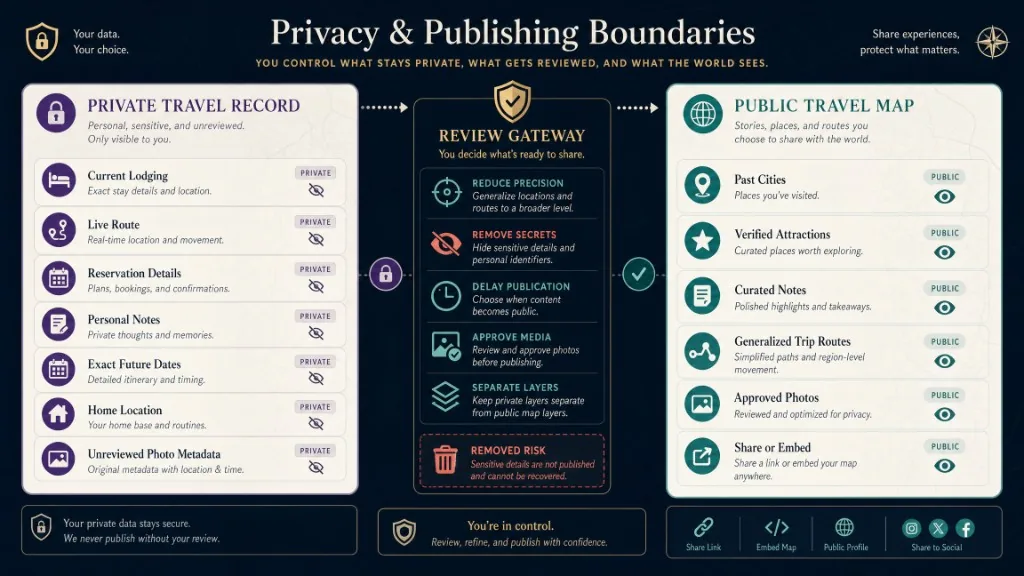
Para los mapas públicos, considere publicar viajes pasados en lugar de movimiento en vivo, mostrar una ciudad en lugar de una dirección de alojamiento precisa, eliminar códigos de reserva y notas personales, separar versiones de mapas privados y públicos, limitar el mapa a dominios aprobados y revisar cada capa antes de compartir. El uso compartido público debe ser una decisión de publicación deliberada, no el incumplimiento accidental de un rastreador de viajes personal.
¿Cómo hacer accesible el mapa de viajes?
Los mapas interactivos pueden crear barreras para los usuarios de teclado, lector de pantalla, baja visión y con discapacidad motora. Proporcione una lista de texto que contenga cada destino mapeado, acceso al teclado para colocar tarjetas y controles, indicadores de enfoque claros, etiquetas para el estado visitado, planificado y favorito, señales de estado no color, contraste legible, objetivos táctiles lo suficientemente grandes para uso móvil, una forma de acceder a los resultados sin arrastrar el mapa, texto alternativo conciso para imágenes significativas y comportamiento de movimiento reducido cuando sea apropiado. WCAG 2.2 sigue siendo una línea de base útil para la interfaz circundante y los controles interactivos. Véase Directrices de accesibilidad de contenido web (WCAG) 2.2. El mapa puede mejorar la experiencia, pero la información esencial de viaje no debería existir solo dentro de un marcador visual no etiquetado.
¿Qué eventos y métricas conviene medir?
Los siguientes nombres de eventos son recomendaciones editoriales, no afirmaciones sobre eventos de Kaleidr Analytics emitidos automáticamente: travel_map_opened, travel_map_pin_selected, travel_map_trip_filter_applied, travel_map_status_filter_applied, travel_map_city_opened, travel_map_route_viewed, travel_map_ai_question_submitted, travel_map_shared, travel_map_embed_loaded, travel_map_external_link_opened, y travel_map_signup_started. Las métricas útiles incluyen la tasa de selección de mapa a pin, los destinos promedio vistos por sesión, el uso del filtro de viaje, la tasa de participación, las visitas de retorno, la tasa de finalización de la pregunta de AI, los clics externos del enlace de lugar, los inicios de personalización de plantillas, los inicios de estudio, la creación de mapas publicados y la adopción de la incrustación del visor. Un alto recuento de apertura de mapa sin selección de pines, uso compartido o de retorno puede indicar que el mapa parece interesante, pero no ayuda a los usuarios a explorar.
¿Qué errores deben evitar quienes crean mapas de viajes?
| Error | ¿Qué pasa | Corrección recomendada |
|---|---|---|
| Añadir cada lugar a una capa | El mapa se vuelve ilegible | Separar viajes, estados o categorías en un pequeño número de capas útiles |
| Latura y longitud de la inversión | Los pines aparecen en la región equivocada | Confirme el orden de coordenadas utilizado por el formato seleccionado |
| Usando solo colores de pin | El estado se vuelve inaccesible | Combina el color con la forma, el contorno, la etiqueta o el texto |
| Publicando el alojamiento actual | El mapa crea un riesgo de privacidad | Publicar después del viaje o reducir la precisión geográfica |
| Tratar una línea de ruta como navegación | Los espectadores pueden interpretar un camino decorativo como direcciones precisas | Etiqueta las rutas decorativas y utilice un servicio de enrutamiento aprobado para las direcciones |
| Añadir texto largo a cada marcador | Las tarjetas de lugar móviles se vuelven difíciles de usar | Mantenga las tarjetas concisas y enlace a páginas de viaje detalladas |
| Dejar que la IA inventar los hechos de los viajes | El mapa puede declarar erróneas fechas, lugares o recuerdos | Datos personales de base en el conjunto de datos del usuario |
| Ignorar el diseño móvil | El mapa y las tarjetas compiten por el espacio limitado | Pruea las hojas inferiores, el mapa/cambio de lista y los objetivos táctiles |
| Publica sin un propósito | El mapa se convierte en una colección de pin misceláneo | Definir una audiencia principal y un caso de uso |
| Medir solo vistas | La curiosidad visual se confunden con el compromiso útil | RealIsto de seguimiento de la selección de pin, el uso compartido, el uso de devolución y la creación de mapas |
¿En qué se diferencia un mapa con pines de un mapa de países visitados?
Los dos formatos se superponen, pero responden a diferentes preguntas. Un mapa de países visitados puede ser una capa o una vista dentro de un mapa de viaje más rico. No cree páginas duplicadas separadas a menos que cada experiencia proporcione una función genuinamente diferente.
| Zona de decisión | Mapa de países visitados | Mapa de viaje con pins |
|---|---|---|
| Unidad primaria | País | Ciudad o lugar individual |
| Objetivo principal | Mostrar cobertura geográfica | Registrar o planificar experiencias específicas |
| Nivel de detalle | Bajo a medio | Medio a alto |
| La mejor interacción | Seleccione o colorear países | Abrir pines, filtrar lugares, ver rutas |
| Mantenimiento | Ocasional | Actualizado por viaje o lugar |
| Caso de uso fuerte | Resumen de viaje personal | Diario, itinerario, guía o sitio de destino |
¿Qué debe incluir la lista final de publicación?
Antes de publicar, confirme que se definen el propósito y la audiencia del mapa; que se selecciona el alcance mundial, regional, de la ciudad o de escala múltiple; que existen ID de lugar estable; que las coordenadas se verifican y se eliminan los duplicados; que se definen los estados visitados y planificados; que el sistema de pin es limitado y consistente; y que el estado de selección está diseñado. Confirme que las rutas se agrupan por viaje, se obtienen reclamos de lugares de hecho, las notas personales se separan de los hechos públicos, se prueban la cámara de apertura y la densidad de marcadores móviles, se separan los datos públicos y privados, se proporciona una lista de accesibilidad, se revisan los derechos de imagen y se revisan el texto alternativo, se verifican la configuración de compartir y dominio, se agregan eventos analíticos y la experiencia publicada se prueba en escritorio y móvil.
Veredicto final
Un útil mapa del mundo de viajes con alfileres es un producto de viaje estructurado, no una colección decorativa de marcadores. Comiencen con un propósito claro, creen un conjunto de datos de lugar consistente, distingan los destinos visitados y planificados y verifiquen cada ubicación. Utilice un sistema visual restringido para que los espectadores puedan entender el historial de viajes sin decodificar una leyenda llena de gente. Agregue rutas, preguntas de inteligencia artificial, fotos y notas detalladas solo cuando admitan la tarea principal del mapa.
Kaleidr Studio es apropiado cuando el objetivo es pasar de un concepto de viaje a un mapa interactivo personalizable. El Viewer es apropiado cuando el mapa terminado debe aparecer en un sitio existente. La plantilla de hostelería es apropiada cuando el mapa necesita un viaje completo o un sitio web de destino a su alrededor.
Crea tu mapa de viajes en Kaleidr Studio
Convierte países, ciudades, viajes y lugares memorables en un mapa interactivo personalizado que puedas perfeccionar y publicar. Empieza a crear en Kaleidr Studio si prefieres un proceso que comienza con instrucciones en lenguaje natural. Conecta un mapa publicado de Studio con la plantilla de hostelería de Kaleidr, personaliza el sitio y añade chat con IA o analítica cuando mejoren la experiencia mediante la plantilla de viajes y hostelería.
Preguntas frecuentes
¿Cómo creo un mapa mundial de viajes con pines?
Elija el propósito del mapa, cree una lista limpia de países, ciudades o lugares, verifique sus coordenadas, asigne un sistema de estado pequeño y construya el mapa en una herramienta de mapa interactiva como Kaleidr Studio. Revise la configuración de diseño y privacidad antes de publicar.
¿Cuál es la mejor forma de crear un mapa de lugares visitados?
Utilice registros de lugar estables con un nombre, ciudad, país, coordenadas, estado de visita, nombre del viaje y fecha o nota opcional. Un conjunto de datos estructurado es más fácil de actualizar y filtrar que los pines colocados manualmente con etiquetas inconsistentes.
¿Qué es un mapa interactivo de países visitados?
Un mapa interactivo de los países visitados permite a un usuario seleccionar, colorear, filtrar o abrir los países que ha visitado. Se centra en la cobertura a nivel de país, mientras que un mapa de pin generalmente registra ciudades o lugares individuales.
¿Puedo crear un mapa de ciudades visitadas en lugar de uno de países?
Sí. Los pines a nivel de la ciudad proporcionan más detalles y funcionan bien para los historiales de viaje largos. Utilice clustering o detalle progresivo para que la visión del mundo no se abarrote.
¿Puedo incluir destinos futuros?
Sí. Utilice un estado planificado visible que difira de los lugares visitados. No haga que los viajes planificados y completados parezcan idénticos.
¿Puede la IA crear automáticamente todo el mapa de viajes?
La IA puede ayudar a generar una estructura inicial, organizar contenido, sugerir categorías o apoyar preguntas sobre el mapa. El editor todavía necesita verificar ubicaciones, fechas, reclamaciones de hechos, configuración de privacidad y la jerarquía visual final.
¿Puedo insertar un mapa de viajes de Kaleidr en un sitio web?
Sí. Un mapa de Studio publicado se puede incrustar con el Viewer de Kaleidr por ID de compartir. La documentación del espectador indica que el visor de mapa publicado no requiere una clave de API, aunque los dominios permitidos definidos por el editor aún se aplican.
¿Necesito una clave de API de Kaleidr para ver un mapa publicado?
No. Viewer está protegido mediante un enlace compartido. Chat, Editor y Tiles utilizan claves publicables a través del SDK, mientras que las llamadas a la API de backend Platform utilizan claves de servidor.
¿Debo publicar un mapa de viajes mientras estoy viajando?
La publicación de alojamiento en vivo, rutas o fechas puede crear riesgos de privacidad y seguridad. Considera la posibilidad de publicar después del viaje, reducir la precisión de la ubicación o mantener una versión privada separada del mapa público.
¿Qué debo medir después de publicar?
Realice un seguimiento de las selecciones de pines, filtros, rutas vistas, recursos compartidos, visitas de retorno, preguntas de inteligencia artificial, enlaces de lugares externos, inicios de estudio y creación de mapas publicados. Las vistas de mapa por sí solas no muestran si la experiencia es útil.
Referencias
- Internet Engineering Task Force. RFC 7946: The GeoJSON Format. Accessed 30 July 2026. https://datatracker.ietf.org/doc/html/rfc7946
- Kaleidr. AI Maps You Can Talk To — Spatial AI. kaleidr.com. Accessed 30 July 2026. https://kaleidr.com/ai
- Kaleidr. Create Custom Maps with AI Map Maker. kaleidr.com. Accessed 30 July 2026. https://kaleidr.com/studio
- Kaleidr. Embed a Published Map. Kaleidr Developer Docs. Accessed 30 July 2026. https://docs.kaleidr.com/guides/embed-a-map
- Kaleidr. Introduction. Kaleidr Developer Docs. Accessed 30 July 2026. https://docs.kaleidr.com
- Kaleidr. Kaleidr Template Customizer — Hospitality. Accessed 30 July 2026. https://template.kaleidr.com/customize/?template=hospitality
- Kaleidr. kaleidr.js — the loader. Kaleidr Developer Docs. Accessed 30 July 2026. https://docs.kaleidr.com/sdk/kaleidr-js
- Kaleidr. Pricing & Plans. kaleidr.com. Accessed 30 July 2026. https://kaleidr.com/pricing
- Kaleidr. Spatial & Audience Analytics Dashboard. kaleidr.com. Accessed 30 July 2026. https://kaleidr.com/analytics
- Kaleidr. Viewer — embed a published map. Kaleidr Developer Docs. Accessed 30 July 2026. https://docs.kaleidr.com/sdk/viewer-embed
- World Wide Web Consortium. Web Content Accessibility Guidelines (WCAG) 2.2. Accessed 30 July 2026. https://www.w3.org/TR/WCAG22/
@misc{ietf_geojson,
  title  = {RFC 7946: The GeoJSON Format},
  author = {{Internet Engineering Task Force}},
  note   = {Accessed 30 July 2026},
  url    = {https://datatracker.ietf.org/doc/html/rfc7946}
}

@misc{kaleidr_studio,
  title  = {Create Custom Maps with AI Map Maker},
  author = {{Kaleidr}},
  note   = {Accessed 30 July 2026},
  url    = {https://kaleidr.com/studio}
}

@misc{kaleidr_viewer,
  title  = {Viewer -- embed a published map},
  author = {{Kaleidr}},
  note   = {Kaleidr Developer Docs; accessed 30 July 2026},
  url    = {https://docs.kaleidr.com/sdk/viewer-embed}
}

@misc{kaleidr_hospitality_template,
  title  = {Kaleidr Template Customizer -- Hospitality},
  author = {{Kaleidr}},
  note   = {Accessed 30 July 2026},
  url    = {https://template.kaleidr.com/customize/?template=hospitality}
}

@misc{wcag22,
  title  = {Web Content Accessibility Guidelines (WCAG) 2.2},
  author = {{World Wide Web Consortium}},
  note   = {Accessed 30 July 2026},
  url    = {https://www.w3.org/TR/WCAG22/}
}