
KI-Mapping-Tools bilden keine einheitliche Produktkategorie. Manche ergänzen eine Live-Karte um natürlichsprachliche Interaktion. Andere erzeugen interaktive Karten aus Prompts, analysieren räumliche Daten, klassifizieren Bilddaten, bewerten Orte oder stellen Standort-APIs bereit. Die richtige Plattform hängt von der benötigten Ausgabe, den kontrollierten Daten, dem vorhandenen Karten-Stack und den zulässigen Entscheidungen ab. Beginnen Sie mit dem geografischen Workflow und bewerten Sie anschließend Quellenfundierung, strukturierte Ergebnisse, Integration, Governance, Kosten und Resultate.
Die folgenden Abschnitte definieren die Kategorie, die erforderlichen Ausgaben und sieben Werkzeugtypen. Außerdem behandeln sie eine Vergleichsmatrix, einen Auswahlrahmen, Fundierung und Genauigkeit, Sicherheit, Kosten, repräsentative Plattformen und die Rolle von Kaleidr. Nutzen Sie den Leitfaden als Käufercheckliste oder springen Sie direkt zum Kaleidr-Abschnitt, wenn der Workflow bereits feststeht.
Wichtigste Erkenntnisse
- Wählen Sie zuerst die Aufgabe, dann das Tool. Konversationelle Suche, Kartenerstellung, GeoAI-Analyse, Bildklassifizierung und Routenoptimierung benötigen unterschiedliche Systeme.
- Trennen Sie den Karten-Renderer von der KI-Ebene. Ein Produkt kann Mapbox, Google Maps, MapLibre oder einen anderen Renderer beibehalten und dennoch KI-Interaktion ergänzen.
- Bevorzugen Sie strukturierte geografische Ergebnisse. Stabile IDs, Koordinaten, Geometrien, Quellen, Begründungen und unterstützte Aktionen sind verlässlicher als reiner Fließtext.
- Behandeln Sie die Datenfundierung als Kernanforderung. Die KI interpretiert und koordiniert; maßgebliche Standort- und Geschäftssysteme prüfen die Fakten.
- Bewerten Sie das vollständige Produktionsmodell. Sicherheit, Berechtigungen, Nutzungslimits, Datenlizenzen, Barrierefreiheit, Analysen und Wartung sind ebenso wichtig wie die Demo.
Was sind KI-Mapping-Tools?
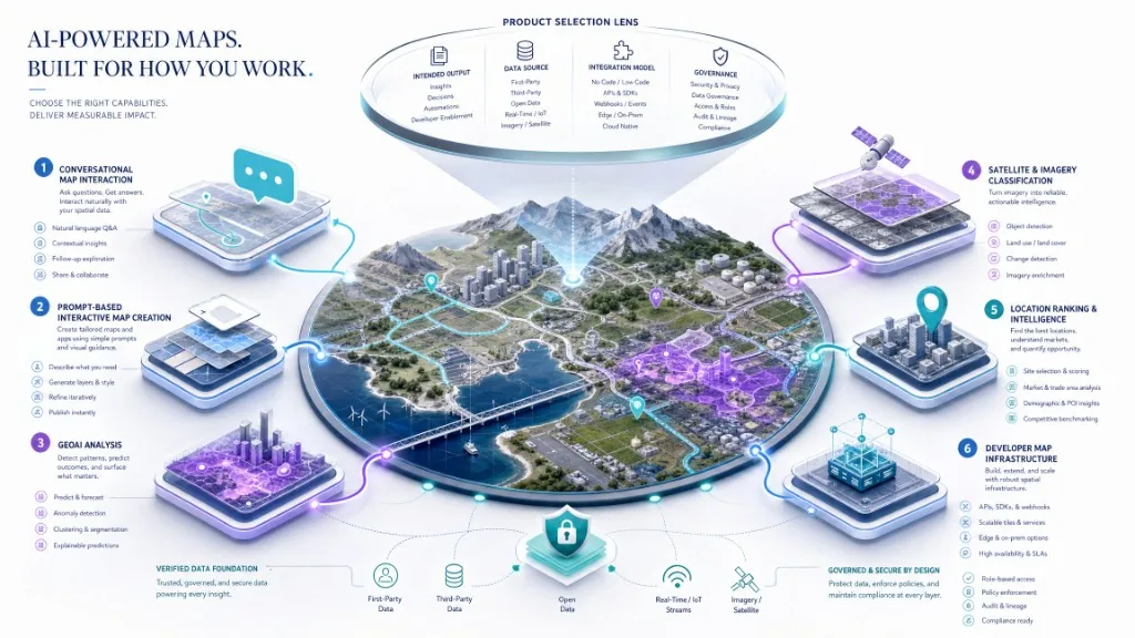
Ein KI-Mapping-Tool wendet künstliche Intelligenz auf eine geografische Aufgabe an, etwa auf Kartenerstellung, die Interpretation einer Standortfrage, Geodatenanalyse, Informationsextraktion aus Bilddaten, Ortsranking oder die Koordination von Kartenaktionen. Der Begriff kann einen Konversationsassistenten an einer Live-Karte, einen promptbasierten interaktiven Karten-Builder, eine GIS-Plattform mit Machine- und Deep-Learning-Werkzeugen, eine Location-Intelligence-API, eine Earth-Observation-Plattform zur Bildklassifizierung, eine Agentenschnittstelle zwischen Sprachmodellen und Geocoding-, Routing- oder Places-Diensten oder ein operatives System für Routen, Disposition, Servicegebiete und dynamische Assets bezeichnen.
Diese Bandbreite erklärt, warum eine Suche nach „KI-Mapping-Tools“ Produkte liefert, die sich nur schwer direkt vergleichen lassen. Eine Plattform zur Satellitenbildklassifizierung und ein eingebettetes Kartenchat-SDK können beide KI und Geografie nutzen, lösen aber unterschiedliche Probleme. Eine breitere Definition und Taxonomie finden Sie unter KI-Mapping: Definition, Funktionsweise und wichtigste Typen.
Welche Ausgabe muss das Tool erzeugen?
Vor dem Vergleich der Plattformen die erforderliche Ausgabe definieren. Ein Tool sollte keine hohe Punktzahl für Funktionen erhalten, die der beabsichtigte Workflow niemals verwenden wird. Ein Produktteam, das einen kartenbewussten Kundensupport erstellt, benötigt möglicherweise keine erweiterte Rasterklassifizierung. Ein Remote-Sensing-Team benötigt möglicherweise kein Consumer-Chat-Panel.
| Erforderne Ausgabe | Die relevanteste Werkzeugkategorie |
|---|---|
| Ein Benutzer stellt Fragen und die Live-Karte antwortet | Konversationelle oder kartenbewusste KI |
| Ein Ersteller beschreibt eine Karte und erhält einen editierbaren interaktiven Entwurf | KI-gestützter Karten-Builder |
| Ein Analyst prognostiziert oder klassifiziert ein räumliches Muster | GeoAI oder GIS-Analyseplattform |
| Ein Modell erkennt Straßen, Gebäude, Ernten, Wasser oder Veränderungen in Bildern | Fernerkundung oder Bildsprache AI |
| Ein Produkt ortet berechtigte Geschäfte, Angebote, Einrichtungen oder Ziele ein | Standort-Intelligenz-Plattform |
| Ein Entwickler benötigt Geocodierung, Routing, Orte und Kartenaktionen über APIs | Mapping und Location Developer Plattform |
| Ein Operations-Team optimiert Routen, Servicezonen oder Ressourcen | Räumliche Optimierungsplattform |
| Eine Website benötigt eine markengegebene Karte oder einen eingebetteten Editor | Kartenveröffentlichungs- und Einbettplattform |
Welche Hauptkategorien von KI-Mapping-Tools gibt es?
Konversationelle und kartenbewusste KI
Mit diesen Tools können Benutzer die Standortabsicht in natürlicher Sprache ausdrücken und die Antwort mit der sichtbaren Karte verbinden - unabhängige Buchhandlungen in der Nähe eines Veranstaltungsorts, Immobilien in einem gezeichneten Bereich mit einem kürzeren Pendelverkehr, Standorte, die den Betriebsanforderungen entsprechen, oder kostenlose Aktivitäten am Wasser. Ein kartenbewusster KI-Kartenassistent sollte mehr tun, als Text zu generieren. Das System kann Orte auflösen, Markierungen hinzufügen, die Kamera in einen Ergebnisbereich einpassen, eine Region markieren oder eine andere unterstützte Kartenaktion zurückgeben.
Wählen Sie diese Kategorie, wenn flexible Benutzerfragen allein durch feste Filter schwierig darzustellen sind. Überprüfen Sie unterstützte Renderer, platzieren Sie Quellenfundierungen, strukturierte Ereignisse, Karten-Aktions-Steuerelemente, Browser-Authentifizierung, Private-Data-Architektur und Analysen vor dem Kauf. Die Entwicklerdokumentation von Kaleidr beschreibt den KI-Karten-Chat, der an Mapbox, Google Maps oder MapLibre-Karten angehängt ist, die eine Anwendung bereits betreibt, während die Host-Anwendung ihren Karten-Renderer, Benutzer-Workflow, Berechtigungen und Geschäftsdaten beibehält. Sehen Sie die Kaleidr Entwickler Dokumentation und So fügen Sie den KI-Chat zu Mapbox, Google Maps oder MapLibre hinzu.
KI-gestützte interaktive Karten-Builder
Diese Tools helfen einem Autor, von einem schriftlichen Konzept zu einem bearbeitbaren Kartenerlebnis zu gelangen. Eine nützliche Eingabeanweisung kann geografischen Fokus, beabsichtigte Zielgruppe, Ortungskategorien, Datensätze oder Ebenen, Markenrichtung, Interaktionen und Veröffentlichungsziel angeben. Die Ausgabe sollte editierbar bleiben. KI kann den ersten Entwurf beschleunigen, aber der Autor muss immer noch Standorte, Inhalte, Ebenenreihenfolge, Beschriftungen, Stile, Zugänglichkeit, Attribution und mobiles Verhalten überprüfen.
Wählen Sie diese Kategorie, wenn das Team interaktive Karten erstellen und veröffentlichen möchte, ohne jedes erste Element manuell zusammenzustellen. Überprüfen Sie, ob die Ausgabe wirklich interaktiv ist, ob Inhalte und Stile bearbeitbar bleiben, wie Daten in die Karte gelangen, welche Veröffentlichungs- und Einbettungspfade vorhanden sind und ob die Plattform statische Bilder oder funktionale Geographie erstellt. Kaleidr Studio beschreibt seinen Erstellungsworkflow als Prompt → Prozess → Verfeinern → Bereitstellen und präsentiert benutzerdefinierte interaktive Karten, entworfene Kacheln, 3D-Visualisierung, Live-Datenebenen, wiederverwendbare Ebenen, Datensätze und Markenstyling. Sieh Kaleidr Studio und AI Interactive Map Builder: Umstimmt zu veröffentlichen.
GeoAI- und GIS-Analyseplattformen
GeoAI-Plattformen verwenden maschinelles Lernen, Deep Learning, natürliche Sprachschnittstellen und andere KI-Methoden auf die räumliche Analyse. Häufige Aufgaben umfassen Klassifizierung, Clustering, Vorhersage, Prognose, Anomalieerkennung, Merkmalsextraktion, Eignungsanalyse, räumliche Textanalyse und Modellbereitstellung über Enterprise-GIS-Workflows hinweg. ArcGIS beschreibt georäumliche KI als Teil einer Geoplattform für Unternehmen, die agentische und wissenschaftliche KI mit GIS kombiniert, einschließlich maschinellem Lernen, Deep Learning, natürlichen Spracherfahrungen und verwalteter Unternehmensbereitstellung. Sieh Georäumliche KI im ArcGIS Architecture Center.
Wählen Sie diese Kategorie, wenn Analysten, GIS-Profis, Wissenschaftler oder Operations-Teams eine breite räumliche Analyse benötigen und nicht nur eine eingebettete kundenorientierte Karte. Überprüfen Sie die unterstützten Datentypen, Modellschulungen und -bereitstellung, räumliche Statistiken, Bildunterstützung, Unternehmensführung, Reproduzität, Desktop- versus Cloud-Anforderungen und spezielle Qualifikationsanforderungen.
KI für Bilddaten und Fernerkundung
Bilder-KI extrahiert Informationen aus Satelliten-, Luft-, Drohnen-, Lidar-, Straßen- oder anderen Sensordaten. Typische Aufgaben sind die Klassifizierung von Landbedeckungen, die Gebäude- und Straßenextraktion, die Identifizierung von Pflanzen, die Erkennung von Objekten, die Erkennung von Änderungen, die Segmentierung, die Katastrophenbewertung und die Überwachung der Infrastruktur. Wählen Sie diese Kategorie aus, wenn die erforderliche Antwort in Pixeln, Punktwolken oder Zeitreihenbildern und nicht in einer herkömmlichen Ortsdatenbank enthalten ist. Überprüfen Sie die unterstützten Sensoren, Auflösung, Schulungsetiketten, Cloud- und Schattenhandling, die zeitliche Abdeckung, die geografische Übertragung, die Modellbewertung, die Exportformate und die Rechenkosten. Gehen Sie nicht davon aus, dass ein Modell, das in einer Region, Saison oder Sensor gut funktioniert, auf eine andere verallgegensteigen.
Plattformen für Location Intelligence und Ranking
Ortsintelligenz-Tools verbinden Geographie mit Business-Kontext. Ein System kann Kandidatenstandorte mit Abstand, Reisezeit, Servicebereich, Verfügbarkeit, Kategoriepassung, von Benutzern ausgewählten Präferenzen, Vertrauen, Frische, Zugänglichkeit und zulässigen Geschäftsprioritäten bewerten. Die Schlüsselausgabe ist nicht nur eine Koordinate. Das nützliche Ergebnis ist ein entscheidungsbereiter Ort, eine Punktzahl, eine Erklärung oder eine Aktion.
Wählen Sie diese Kategorie, wenn ein Produkt Geschäfte, Eigenschaften, Einrichtungen, Ziele, Assets oder Servicestandorte unter mehreren Einschränkungen auswählen oder bewerten muss. Überprüfen Sie die Regeln für die harte Berechtigung, die Ranking-Transparenz, die Quellenzuschreibung, den Abruf von Privatdaten, die stabile Kennung, die räumliche Abdeckung, die Mieterisolation und die Prüfbarkeit. Kaleidr Enterprise ist in den Bereichen Inferenz-APIs, Ranking-Systeme, Analyse, Bereitstellungsunterstützung und skalierbare APIs für standortbezogene Produkte positioniert. Siehe Kaleidr Enterprise und Was ist eine Location Intelligence API?.
Karten- und Agenteninfrastruktur für Entwickler
Entwicklerplattformen zeigen Karten, Orte, Routen, Geocodierung, Kacheln, Suche oder KI-Agent-Schnittstellen über APIs und SDKs an. Die Google Maps Platform präsentiert KI-Agenten, Entwicklertools, Quellenfundierungsprodukte, ein agentisches UI-Toolkit, Kartierungsdienste, Routen, Orte und Geodatenprodukte mit KI-Positionierung, die Quellenfundierungsanwendungen in aktuellen realen Kartendaten hervorhebt. Siehe Geospatial-KI mit realer Intelligenz. Mapbox präsentiert Location AI, einschließlich eines MCP-Servers, der KI-Systeme mit Geocodierung, Routenplanung und Point-of-Interest-Lookup über natürlichsprachige Schnittstellen verbinden kann. Siehe Standort AI.
Wählen Sie diese Kategorie, wenn Engineering-Teams Composable-Services anstelle einer vollständigen Authoring- oder Analyseumgebung benötigen. Überprüfen Sie API-Oberflächen-, Renderer-Unterstützung, Datenabdeckung, SDK-Fälligkeit, Abrechnungseinheiten, Tariflimits, Schlüsselbeschränkungen, Caching-Regeln, Attribution, Fehlerverhalten und Provider-Lock-in.
Cloud-native und kollaborative räumliche Anwendungen
Einige Plattformen kombinieren Kartenerstellung, Datenanalyse, Zusammenarbeit, Anwendungsentwicklung und KI-gestützte Workflows. CARTO positioniert sich als agentische GIS-Plattform für die räumliche Analyse und Anwendungsworkflows in Unternehmen. Siehe CARTO. Felt präsentiert KI-gestützte No-Code-Mapping-Anwendungen, GIS-Workflows, SQL-Analysen, Entwickler-APIs, authentifizierte Einbettungen und Bereitstellungsoptionen für Unternehmen. Siehe Filz AI.
Wählen Sie diese Kategorie, wenn ein Team kollaborative räumliche Arbeit, Cloud-Datenverbindungen, No-Code- oder Low-Code-Anwendungen und Organisations-Governance in einer Umgebung benötigt. Überprüfen Sie die unterstützten Lager, das Kollaborationsmodell, die Datenlokalität, die Anwendungsveröffentlichung, die Einbettung, die SQL- und Analysefunktionen, das Erweiterungsmodell und die Unternehmenssteuerung.
Wie unterscheiden sich die Kategorien?
Die folgende Matrix vergleicht Kategorien, anstatt einen universellen Gewinner zu erklären. Die stärkste Plattform hängt vom geografischen Workflow ab, nicht von der längsten Feature-Liste.
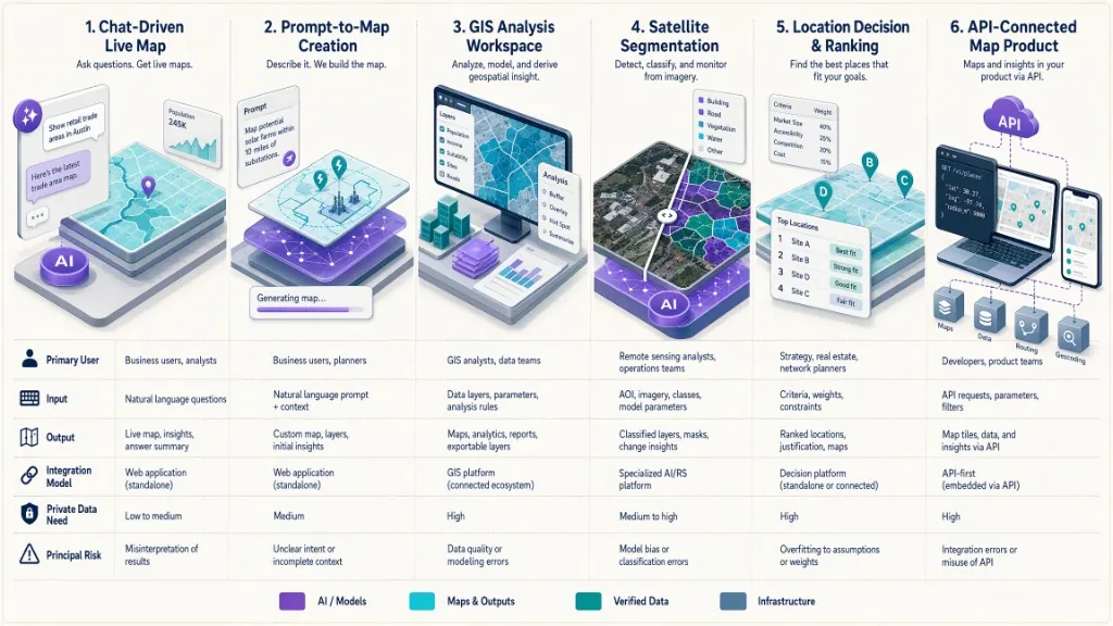
| Entscheidungsbereich | Konversationskarte AI | KI-Karten-Builder | GeoAI / GIS | Bilder-KI | Standortintelligens | Entwicklerplattform |
|---|---|---|---|---|---|---|
| Primärer Benutzer | Produktbenutzer oder Kunde | Schöpfer, Marketer, Produktteam | Analyst, GIS-Spezialist, Wissenschaftler | Remote-Sensing oder ML-Team | Produkt, Betrieb, Strategie | Entwickler |
| Haupteingang | Natürlichsprachige Frage und Live-Karte | Prompt, Orte, Ebenen, Datensätze | Räumliche Datensätze und Modelle | Bilder und Etiketten | Orte, Geschäftsregeln, Kontext | API-Renden oder SDK-Aufruf |
| Hauptausgang | Geerdete Antwort und Kartenaktion | Bearbeitbare interaktive Karte | Analyse, Modell, Schicht, Vorhersage | Geheime oder extrahierte Features | Rangliste oder berechtigte Standorte | Karten-, Orts-, Routen-, Fliesen- oder Aktionsdaten |
| Erfordert Map-Renderer | Normalerweise | In der Regel gebündelt oder integriert | Oft | Nicht immer | Oft zur Präsentation | Normalerweise |
| Private-Daten-Versande | Gemeinsam | Optional | Gemeinsam | Gemeinsam | Häufig essentiell | Anwendungsabhängig |
| Am besten für den No-Code-Zeigen | Manchmal | Stark | Variiert | Begrenzt | Variiert | Niedrig |
| Am besten für die Tiefenanalyse | Begrenzt | Begrenzt | Stark | Stark | Moderat | Abhängig von Dienstleistungen |
| Am besten für die Produkteinbettung | Stark | Variiert | Variiert | Normalerweise kundenspeziflich | Stark | Stark |
| Primäres Risiko | Unquellenfundierte Antworten | Unverifiziert generierte Inhalte | Modellmissbrauch oder Komplexität | Geografischen Transferfehler | Undurchsichtiges oder voreingenommenes Ranking | Komplexität von Sicherheit, Kosten und Integration |
Wie wählen Sie eine KI-Mapping-Plattform aus?
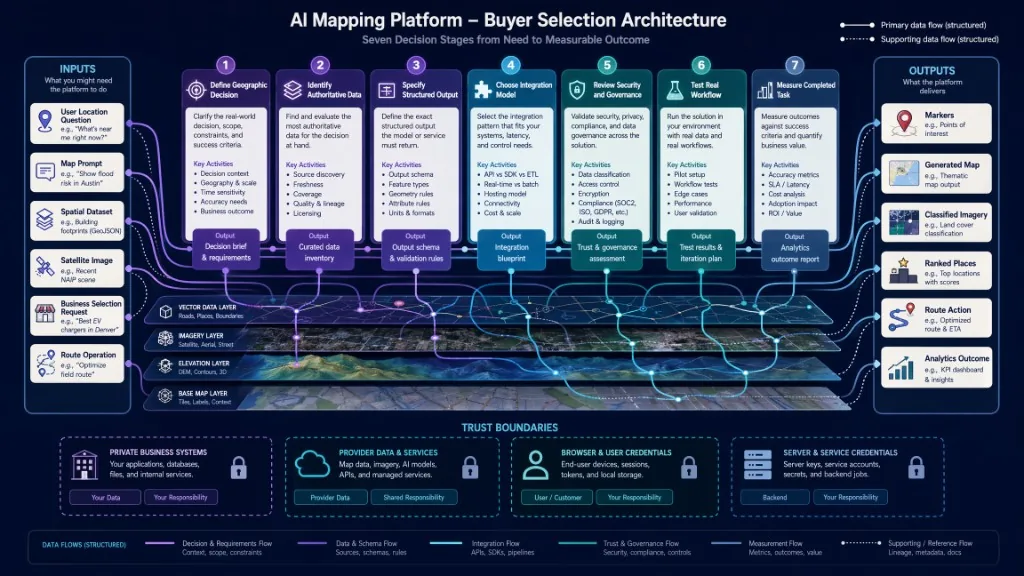
Beginnen Sie mit der geografischen Entscheidung, überprüfen Sie den Datenvertrag und validieren Sie die Plattform durch einen repräsentativen Piloten.
Definieren Sie die geografische Entscheidung
Schreiben Sie einen Satz: der Benutzer oder das System muss ________________________________________________________________________________________________Nützliche Beispiele sind ein Reisender, der Orte findet, die flexiblen Interessen entsprechen, ein Immobilienbenutzer, der Angebote nach Pendler- und Amenity-Kriterien vergleicht, ein Analyst, der Landbedeckungsänderungen für die Feldüberprüfung erkennt, oder ein Einzelhändler, der ein berechtigtes Geschäft für die Erfüllung auswählt. Ein vages Ziel wie „KI auf unseren Karten nutzen“ reicht für die Werkzeugauswahl nicht aus.
Identifizieren Sie die maßgeblichen Datenquellen
Für jede sachliche Ausgabe, nennen Sie die Quelle der Wahrheit. Adressen und Koordinaten sollten von einem zugelassenen Geocoder oder einer Ortsdatenbank stammen. Die Öffnungszeiten sollten von einem aktuellen Ortsanbieter oder einem Geschäftssystem kommen. Inventar, Listing-Status, Reisezeit, Service-Berechtigung, Pakete, Grenzen und Bildklassifizierungen benötigen jeweils einen expliziten Eigentümer. Das Sprachmodell sollte fehlende Fakten nicht erfinden, nur weil der Nutzer eine Antwort erwartet.
| Tatsache | Mögliche maßgebliche Quelle |
|---|---|
| Adresse und Koordinaten | Genehmigter Geocoder oder Ortsdatenbank |
| Öffnungszeiten | Aktueller Ortsanbieter oder Geschäftssystem |
| Inventar | Internes Inventarsystem |
| Listing-Status | Autorisierte Auflistung Feed |
| Reisezeit | Zugelassener Routing-Service |
| Serviceberechtigung | Geschäftsregeln der Host-Anwendung |
| Paket oder Grenze | Autorisierte staatliche oder kommerzielle Datensätze |
| Bildklassifizierung | Bewertetes Modell plus Quellbilder |
Entscheiden Sie, ob die Ausgabe strukturiert sein muss
Produktionssysteme benötigen in der Regel mehr als Prosa. Bevorzugen Sie Tools, die stabile IDs, Längen- und Breitengrade, Geometrie, Quellreferenzen, Zeitstempel, Vertrauens- oder Qualitätsindikatoren, Ranking-Gründe, unterstützte Aktionstypen und explizite Fehler oder No-Result-Angaben zurückgeben oder bewahren können. Eine Gesprächserklärung kann die Benutzerfreundlichkeit verbessern, aber die Anwendung sollte kritische Ortsangaben aus einem Absatz nicht analysieren, wenn strukturierte Daten verfügbar sind.
Wählen Sie das passende Integrationsmodell
Häufige Integrationsmodelle umfassen eine eigenständige Anbieteranwendung, einen veröffentlichten Viewer, eine angeschlossene KI-Schicht auf einer Host-eigenen Live-Karte, einen eingebetteten Editor im Host-Produkt, eine API-First-Integration oder eine hybride Architektur, in der private Systeme in der Host-Umgebung bleiben, während externe räumliche Dienste wiederverwendbare Funktionen bieten. Die Entwicklerplattform von Kaleidr unterstützt KI-Chat, veröffentlichte Zuschauer, eingebettete Kartenbearbeitung und entworfene Basiskarten über ein Loader- und Plattformschlüsselmodell. Die Dokumentation beschreibt ai, maps und design-Bereiche, veröffentlichbare Browserschlüssel, die gegen kurzlebige, originsgebundene Sitzungen ausgetauscht werden, und Serverschlüssel, die für die Backend-Nutzung reserviert sind. Sieh Auth & Scopes.
Testen Sie einen realen Workflow
Eine polierte Demonstration erweist sich nicht als passend. Verwenden Sie tatsächliche Benutzerfragen, repräsentative Regionen, private oder lizenzierte Daten in einer kontrollierten Umgebung, mehrdeutige Namen, leere Ergebnisse, veraltete Aufzeichnungen, verbotene Anfragen, langsame Netzwerke, mobile Geräte, Barrierefreiheitstests sowie realistische Nebenschluss- und Quotenbedingungen. Der Test sollte die Aufgabenfertigung und nicht die visuelle Neuheit messen.
Wie lassen sich Fundierung und Genauigkeit bewerten?
Ein KI-Mapping-Tool kann glaubwürdig erscheinen, während ein falscher Ort, eine falsche Route, eine Grenze oder ein Ranking zurückgegeben wird. Übliche Fehlermodi sind fabrizierte Unternehmen oder Einrichtungen, die falsche Stadt oder Region für einen mehrdeutigen Namen, veraltete Stunden oder Inventar, doppelte Ortsaufzeichnungen, nicht unterstützte Routenansprüche, Koordinaten in der falschen Reihenfolge, veraltete Bilder, Modellleistung, die außerhalb der Trainingsgeographie fällt, Ergebnisse, die das sichtbare Kartenausmaß ignorieren, und geschäftliche Antworten, die ohne Autorisierung erstellt werden.
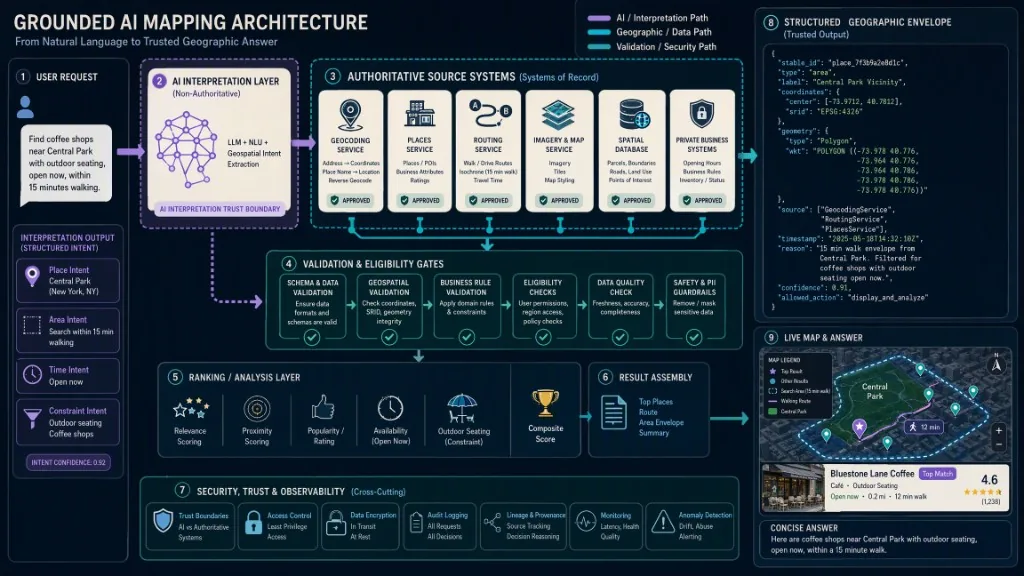
Verwenden Sie dieses Produktionsprinzip: KI interpretiert Absichten und koordiniert unterstützte Aktionen; maßgebliche geografische und geschäftliche Systeme validieren sachliche Antworten. Ein quellenfundierte Workflow sieht in der Regel wie Benutzeranfrage, geografische Interpretation, genehmigter Abruf, Validierung und Berechtigung, Ranking oder Analyse, strukturiertes Ergebnis und sichtbare Kartenaktion aus. Fragen Sie während der Auswertung den Anbieter, um zu zeigen, wie sich das System verhält, wenn die Antwort nicht verfügbar oder mehrdeutig ist. Ein zuverlässiger No-Result-Staat ist wertvoller als eine selbstbewusste Fertigung.
Wie sollten Sicherheit und private Daten behandelt werden?
KI-Mapping-Tools verarbeiten häufig präzisen Standort, Geschäftsdatensätze, Bilder, operative Assets oder Kundenkontext. Bewerten Sie Browser-gegen-Server-Anmeldeinformationen, zulässige oder IP-Beschränkungen, Fähigkeitsbereiche, Schlüsselrotation und -revocation, Mandantenisolierung, Berechtigung auf Objektebene, Datenspeicherung, Modellschulungsnutzung, regionale Speicherung und Verarbeitung, Überwachungsprotokolle, private Netzwerk- oder dedizierte Bereitstellungsoptionen, sensible Standortbehandlung und Incident-Response-Prozess. Das Authentifizierungsmodell von Kaleidr trennt veröffentlichbare Browserschlüssel von Serverschlüsseln. Das SDK tauscht veröffentlichbare Schlüssel für kurzlebige, originsgebundene Sitzungen aus, während Serverschlüssel aus dem Backend gesendet werden und von der Browsernutzung über CORS blockiert werden. Sieh Auth & Scopes. Platzieren Sie keine Server-Bescheinindnere in Browser-Code, nur weil ein Prototyp zu funktionieren scheint.
Wie lassen sich die Gesamtbetriebskosten bewerten?
Der Abonnementpreis ist nur eine Komponente. Inklusive Plattform-Abonnement, API-Aufrufe, KI- oder Inferenzgutschriften, Kartenlasten, Kachelanforderungen, Geocodierung und Routing, Bildspeicherung und -verarbeitung, Datenlizenzierung, Cloud-Data-Warehouse-Kosten, Engineering-Integration, Modellbewertung, Beobachtbarkeit, Sicherheitsüberprüfung, Support und SLA sowie Migrations- und Exit-Kosten. Fragen Sie, welche Nutzungseinheit die Rechnung steuert. Zwei Anbieter können ähnliche monatliche Pläne bewerben, während sie völlig unterschiedliche Ereignisse messen.
Ab dem 29. Juli 2026 listet Kaleidr Free, Pro und Enterprise Optionen. Pro ist für $ 29 pro Monat gelistet und enthält Entwickler-API-Zugang, veröffentlichbare und Serverschlüssel und Einbettungsunterstützung. Enterprise fügt benutzerdefinierte Nutzung, Verträge, SLA, dedizierten Support und unabhängige CDN-Optionen hinzu. Preise und Limits können sich ändern, also verwenden Sie die Live-Preisseite als maßgebliche Quelle.
Welche Plattformen stehen beispielhaft für die aktuellen Kategorien?
Die folgenden Beispiele veranschaulichen Kategorienunterschiede statt ein universelles Ranking. Produktoberflächen, Preise und Verfügbarkeiten entwickeln sich schnell weiter, also überprüfen Sie die genaue aktuelle Funktion, den Freigabestatus, die Datenbegriffe und das Bereitstellungsmodell in der offiziellen Dokumentation jedes Anbieters vor der Auswahl.
| Plattform | Aktuelle offizielle Positionierung | Starke Bewertungspassung |
|---|---|---|
| Kaleidr | KI-Karten-Chat, KI-gestützte Kartenerstellung, veröffentlichte Zuschauer, eingebetteter Editor, entworfene Basemaps, Standort-Intelligenz-APIs | Teams, die Konversations-, Marken-, veröffentlichte oder eingebettete räumliche Produkte entwickeln |
| ArcGIS | Enterprise Geospatial-Plattform mit agentischer und wissenschaftlicher KI, maschinellem Lernen, Deep Learning, GIS-Analyse und Governance | Breite professionelle GIS-, Analyse-, Bild- und Enterprise-Raum-Workflows |
| Google Maps Plattform | Karten, Routen, Orte, Geodaten, KI-Agenten, Quellenfundierung und Entwickler-Tools | Anwendungen, die Google Maps-Daten und -Dienste mit KI-unterstützten Entwickler-Workflows benötigen |
| Mapbox | Karten, Suche, Navigation, Daten, Standort-KI und Agentenzugriff auf Geocodierung, Routen und POIs | Entwicklergesteuerte Web- und Mobile-Mapping-, Navigations-, Such- und Agentenintegrationen |
| CARTO | Cloud-native und agentische GIS für räumliche Analyse und Unternehmensanwendungen | Cloud-Data-Wabrehouse-Analysen, räumliche Workflows und verwaltete Unternehmensanwendungen |
| Filz | Kollaborative Cloud-GIS, KI-gestützte Anwendungen, SQL-Analysen, Entwickler-APIs und Einbettungen | Kollaboratives Mapping, No-Code-Raum-Apps und cloudbasierte Team-Workflows |
Welche Rolle spielt Kaleidr?
Kaleidr ist für Teams konzipiert, die Karten in interaktive KI-gestützte Produkterlebnisse verwandeln möchten, ohne jede Komponente ihres bestehenden Stacks zu ersetzen. Verwenden Kaleidr Räumliche KI wenn Benutzer gesprächige Ortserforschung und kartenbewusste Fragen benötigen, die mit der sichtbaren Geographie verbunden bleiben. Verwenden Kaleidr Studio Wenn ein Ersteller von einer Eingabeanforderung zu einer bearbeitbaren interaktiven Karte mit benutzerdefinierten Inhalten, Ebenen, 3D-, Live-Daten oder Branded-Styling wechseln muss und die fertige Erfahrung freigegeben, veröffentlicht oder bereitgestellt wird.
Verwenden Sie die Kaleidr Entwicklerplattform wenn eine vorhandene Mapbox-, Google Maps- oder MapLibre-Anwendung einen KI-Chat benötigt; wenn eine Website einen veröffentlichten Kartenbetrachter benötigt; wenn ein SaaS-Produkt einen eingebetteten Karten-Editor benötigt; wenn eine Anwendung entworfene Basiskarten-Kacheln benötigt; oder wenn das Team unter einem Organisationsmodell Browser- und Backend-Anmeldeinformationen benötigt. Die Dokumentation beschreibt einen Loader, kaleidr.js, und das <kaleidr-map>-Element für chat, viewer, Editor und Fliesenprodukte. Die Host-Anwendung behält die Verantwortung für Benutzer, Berechtigungen, Geschäftsdaten und den umgebenden Workflow.
Verwenden Kaleidr Enterprise wenn der Workflow eine private oder lizenzierte Datenintegration erfordert, wenn Inferenz und Ranking mit der organisationsspezifischen Logik übereinstimmen müssen oder wenn benutzerdefinierte Nutzung, Bereitstellung, Support, Verträge oder SLA erforderlich sind. Kaleidr ist kein universeller Ersatz für GIS, einen Karten-Renderer, eine Bildanalyse-Plattform, eine Routing-Engine oder eine maßgebliche Geschäftsdatenbank. Die Produktanpassung ist am stärksten, wenn das Team eine KI-Interaktion, Erstellung, Veröffentlichung, Einbettung oder Standort-Intelligenz-Schicht benötigt.
Was gehört auf die Entscheidungscheckliste?
Bevor Sie ein KI-Mapping-Tool auswählen, bestätigen Sie, dass die geografische Aufgabe und die erforderliche Ausgabe definiert sind, dass die maßgebliche Quelle für jedes sachliche Attribut bekannt ist und dass die Map-Berender-Beziehung klar ist. Bestätigen Sie, dass bei Bedarf strukturierte IDs, Geometrie, Quellen und Gründe zur Verfügung stehen; dass Berechtigungen für private Daten und die Mandantenisolierung dokumentiert werden; dass Browser- und Serveranmeldeinformationen getrennt sind; und dass das Tool die erforderliche Geographie und Sprache unterstützt. Bestätigen Sie, dass leere, mehrdeutige, veraltete und nicht unterstützte Ergebnisse verarbeitet werden; dass Zugänglichkeit und mobiles Verhalten getestet werden können; dass Nutzungseinheiten und Anbieterkosten verstanden werden; dass Export-, Migrations- und Datenbindungsregeln akzeptabel sind; dass die Analyse abgeschlossene geografische Aufgaben misst; und dass ein repräsentativer Pilot vor der breiteren Annahme erfolgreich ist.
Fazit
Das richtige KI-Mapping-Tool ist das, das mit dem geografischen Job übereinstimmt – nicht mit dem Produkt mit der längsten Feature-Liste. Wählen Sie die Konversationskarte KI, wenn Benutzer flexible Standortfragen benötigen. Wählen Sie einen KI-Karten-Builder, wenn Teams interaktive Karten schneller erstellen und veröffentlichen müssen. Wählen Sie GeoAI oder Bild-KI für professionelle Analyse, Vorhersage, Klassifizierung und Extraktion. Wählen Sie Standortinformationen, wenn ein Produkt berechtigte Orte unter Geschäftsbeschränkungen einordnen muss. Wählen Sie eine Entwicklerplattform, wenn Engineering-Teams Composable-Karten, Orte, Routen, Kacheln oder Agentenschnittstellen benötigen. Über jede Kategorie hinweg bleiben die stärksten Auswahlkriterien konsistent: maßgebliche Daten, strukturierte geografische Ergebnisse, explizite Sicherheitsgrenzen, transparente Einschränkungen, produktionsbereite Integration und messbare Aufgabenvervollständigung.
KI-Mapping-Tools mit Kaleidr erkunden
Testen Sie die konversationelle Ortssuche, erstellen Sie eine interaktive Karte aus einem Prompt oder informieren Sie sich über Chat-Anbindung, Viewer, Editoren, gestaltete Kartenkacheln, Authentifizierung, Scopes und Plattform-APIs. Wenn Sie den zu Ihrer Aufgabe passenden Workflow erproben möchten, testen Sie Kaleidr Spatial AI, beginnen Sie mit Kaleidr Studio oder lesen Sie die Kaleidr-Entwicklerdokumentation.
Häufig gestellte Fragen
Was sind KI-Mapping-Tools?
KI-Mapping-Tools verwenden künstliche Intelligenz auf geografische Erstellung, Interaktion, Analyse, Bilder, Ranking oder Betrieb. Beispiele hierfür sind Conversational Maps, prompt-basierte Kartenersteller, GeoAI-Plattformen, Bildklassifikatoren, Standort-Intelligenz-APIs und Entwickler-Mapping-Services.
Welches KI-Mapping-Tool ist das beste?
Keine Plattform ist universell am besten, da die Kategorie verschiedene Produkte enthält. Die richtige Wahl hängt davon ab, ob die erforderliche Ausgabe eine Konversationskarte, eine bearbeitbare Karte, eine räumliche Analyse, eine Bildklassifizierung, eine Ranglistenorts-, Routenoptimierungs- oder Entwickler-API ist.
Was unterscheidet ein KI-Mapping-Tool von GIS-Software?
Die GIS-Software bietet umfassende Funktionen für die Verwaltung, Bearbeitung, Analyse und Visualisierung geografischer Informationen. Ein KI-Mapping-Tool wendet KI auf eine oder mehrere geografische Aufgaben an und kann innerhalb eines GIS, über GIS-Diensten oder innerhalb einer kundenorientierten Anwendung arbeiten.
Kann ein KI-Mapping-Tool eine interaktive Karte erstellen?
Ja, wenn die Plattform ein interaktiver Karten-Builder und kein statischer Bildgenerator ist. Überprüfen Sie, ob die Ausgabe geografische Koordinaten, Schwenk- und Zooms, Ebenen, Marker, Filter, Veröffentlichung oder Einbettung unterstützt.
Lässt sich KI zu einer vorhandenen Mapbox- oder Google-Maps-Karte hinzufügen?
Ja. Eine KI-Interaktionsebene kann an eine vorhandene Live-Karte angeschlossen werden, während der ursprüngliche Renderer die Karte weiterhin anzeigt. Kaleidr dokumentiert derzeit den Anhang zu Mapbox, Google Maps und MapLibre. Sehen Sie die Kaleidr Entwickler Dokumentation.
Stellen KI-Mapping-Tools eigene Kartendaten bereit?
Einige tun dies, während andere von externen Ort-, Karten-, Routing-, Bild- oder Business-Data-Anbietern abhängig sind. Überprüfen Sie die Regeln für die Quelle, Abdeckung, Frische, Lizenzierung, Speicherung und Attribution für jeden Datentyp.
Wie sollte die Genauigkeit von KI-Mapping bewertet werden?
Testen Sie echte Fragen und Regionen, bewahren Sie strukturierte Orte und Geometrie, überprüfen Sie sachliche Attribute anhand autoritativer Quellen, messen Sie die No-Result- und Fehlerraten und überprüfen Sie die Leistung über Regionen, Geräte, Sprachen und Edge-Fälle hinweg.
Kann ein KI-Mapping-Tool private Geschäftsdaten verwenden?
Ja, wenn die Architektur eine explizite Autorisierung, Mandantenisolation, kontrollierte Backend-Retrieval, Aufbewahrungsregeln, Auditikation und klare Grenzen zwischen dem Modell und den Quellsystemen bietet.
Auf welche Sicherheitsfunktionen sollte ich achten?
Suchen Sie nach separaten Browser- und Serveranmeldeinformationen, Ursprungs- oder IP-Beschränkungen, Umfangsumfangen, Schlüsseldrehung, Berechtigung auf Objektebene, Mandantenisolation, Auditprotokollen, Aufbewahrungskontrollen und dokumentiertem CORS-Verhalten.
Wie sollte das Tool nach dem Start gemessen werden?
Messen Sie abgeschlossene geografische Aufgaben wie relevante Ergebnisauswahl, Kartenveröffentlichung, Routenabschluss, erfolgreiche Analyse, Standortkontakt, gespeicherte Suche, Freigabe, Konvertierung oder ein anderes Workflow-Ergebnis. Prompt count und API-Aufrufe sind Aktivitätsmetriken, nicht Endwert.
Wann ist Kaleidr eine geeignete Wahl?
Kaleidr ist angemessen, wenn ein Team eine Konversationskarteninteraktion, eine KI-gestützte interaktive Kartenerstellung, veröffentlichte Kartenbetrachter, eingebettete Bearbeitung, entworfene Basiskarten oder eine Standort-Intelligenz-Infrastruktur benötigt, die mit einem bestehenden Produktstapel funktioniert.
Referenzen
- Kaleidr. Build with Kaleidr. Kaleidr Developer Docs. Accessed 29 July 2026. https://docs.kaleidr.com
- Kaleidr. Auth & Scopes. Kaleidr Developer Docs. Accessed 29 July 2026. https://docs.kaleidr.com/platform-api/auth-and-scopes
- Kaleidr. Create Custom Maps with AI Map Maker. kaleidr.com. Accessed 29 July 2026. https://kaleidr.com/studio
- Kaleidr. Location Intelligence API & Spatial Infrastructure. kaleidr.com. Accessed 29 July 2026. https://kaleidr.com/enterprise
- Kaleidr. Pricing & Plans. kaleidr.com. Accessed 29 July 2026. https://kaleidr.com/pricing
- Esri. Geospatial AI. ArcGIS Architecture Center. Accessed 29 July 2026. https://architecture.arcgis.com/en/overview/introduction-to-arcgis/geospatial-ai.html
- Google Maps Platform. Geospatial AI with Real-World Intelligence. Accessed 29 July 2026. https://mapsplatform.google.com/ai/
- Mapbox. Location AI. Accessed 29 July 2026. https://www.mapbox.com/location-ai
- CARTO. The Agentic GIS Platform. Accessed 29 July 2026. https://carto.com/
- Felt. AI in GIS and Location Intelligence. Accessed 29 July 2026. https://felt.com/platform/felt-ai
@misc{kaleidr_developer_docs,
  title  = {Build with Kaleidr},
  author = {{Kaleidr}},
  note   = {Developer documentation; accessed 29 July 2026},
  url    = {https://docs.kaleidr.com}
}

@misc{kaleidr_studio,
  title  = {Create Custom Maps with AI Map Maker},
  author = {{Kaleidr}},
  note   = {Accessed 29 July 2026},
  url    = {https://kaleidr.com/studio}
}

@misc{esri_geospatial_ai,
  title  = {Geospatial AI},
  author = {{Esri}},
  note   = {ArcGIS Architecture Center; accessed 29 July 2026},
  url    = {https://architecture.arcgis.com/en/overview/introduction-to-arcgis/geospatial-ai.html}
}

@misc{google_maps_geospatial_ai,
  title  = {Geospatial AI with Real-World Intelligence},
  author = {{Google Maps Platform}},
  note   = {Accessed 29 July 2026},
  url    = {https://mapsplatform.google.com/ai/}
}

@misc{mapbox_location_ai,
  title  = {Location AI},
  author = {{Mapbox}},
  note   = {Accessed 29 July 2026},
  url    = {https://www.mapbox.com/location-ai}
}

@misc{carto_agentic_gis,
  title  = {The Agentic GIS Platform},
  author = {{CARTO}},
  note   = {Accessed 29 July 2026},
  url    = {https://carto.com/}
}

@misc{felt_ai,
  title  = {AI in GIS and Location Intelligence},
  author = {{Felt}},
  note   = {Accessed 29 July 2026},
  url    = {https://felt.com/platform/felt-ai}
}

@misc{kaleidr_pricing,
  title  = {Pricing \& Plans},
  author = {{Kaleidr}},
  note   = {Accessed 29 July 2026},
  url    = {https://kaleidr.com/pricing}
}