
Eine Location-Intelligence-API verwandelt Koordinaten, Orte, Routen, Geschäftsdaten und räumlichen Kontext in anwendungsfertige Entscheidungen und Aktionen. Sie koordiniert Geodienste mit Ranking, Inferenz, Geschäftsregeln und Analysen, damit ein Produkt beantworten kann, welcher Standort zu einer Anfrage passt, welches Servicegebiet reagieren soll und welches geografische Muster als Nächstes relevant ist.
Einfache Standortdienste geokodieren Adressen, suchen Orte in der Nähe, berechnen Routen oder zeigen Karten. Location Intelligence verbindet diese Signale zusätzlich mit Kontext und Produktvorgaben. Deshalb unterstützt derselbe Stack lokale Entdeckung, Filialauswahl, Außendienst und Risikoprüfung. Die folgenden Abschnitte definieren die Kategorie, grenzen sie von benachbarten APIs ab und erläutern Fähigkeiten, Architektur, Bewertung und Governance.
Was ist eine Location-Intelligence-API?
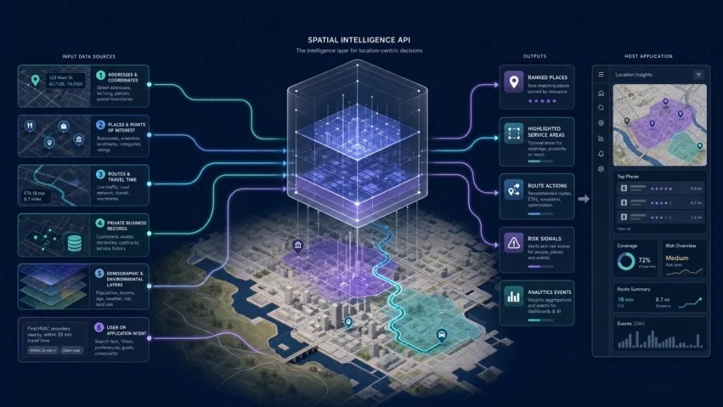
Sie ist eine programmierbare Schnittstelle, die Geodaten und Standortkontext in anwendungsfertige Ergebnisse umsetzt. Eine vollständige Lösung kann Geokodierung und Reverse-Geokodierung, Orts- und POI-Abruf, räumliche Suche und Filter, Nähe- und Servicegebietslogik, Routing und Reisezeitanalyse, Ranking und Empfehlungen, natürlichsprachliche Inferenz, Kartenaktionen, Anreicherung mit Geschäftsdaten und räumliche Analysen verbinden. Esri definiert Location Intelligence als Erkenntnisse aus Visualisierung und Analyse von Geodaten, häufig durch Kombination von Demografie, Verkehr, Umwelt, Wirtschaft und Wetter. Das Open Geospatial Consortium definiert Standards zum Erstellen, Ändern und Abfragen geografischer Features über Web-APIs—eine Datengrundlage für höhere Intelligenzschichten.
Entscheidend ist die Ausgabe. Ein normaler Dienst liefert etwa die Koordinaten 38.8977, -77.0365. Eine Intelligence-Schicht kann erklären, dass eine Klinik der nächstgelegene zulässige Standort ist, im erlaubten Betriebsgebiet liegt, 12 Minuten Reisezeit benötigt und zwei Alternativen wegen fehlender Fähigkeiten niedriger rangieren. Dafür braucht es Koordinaten, räumliche Beziehungen, Geschäftsregeln, Ranking und Kontext—nicht nur Geokodierung.
Wie unterscheidet sie sich von Karten-APIs?
Standorttechnik besteht aus mehreren überlappenden Kategorien. Darstellungs-APIs zeigen Kacheln, Stile, Kameras, Marker und Polygone. Geokodierung wandelt Adressen in Koordinaten und zurück. Ortssuche liefert benannte Orte, Unternehmen und Kategorien. Routing berechnet Wege, Zeiten, Entfernungen und Schritte. Raumdaten-APIs fragen Features und Eigenschaften ab; Analyse-APIs messen Beziehungen, Cluster, Abdeckung und Muster. Eine Location-Intelligence-API liegt darüber und verbindet Dienste, Kontext, Ranking, Inferenz und Geschäftslogik zu entscheidungsfertigen Orten, Aktionen, Erklärungen und Signalen.
| API-Kategorie | Hauptaufgabe | Typische Ausgabe |
|---|---|---|
| Karten- oder Darstellungs-API | Karte und interaktive Ebenen anzeigen | Kacheln, Stil, Kamera, Marker, Polygone |
| Geokodierungs-API | Adresse/Beschreibung in Koordinaten oder zurück umwandeln | Breite, Länge, formatierte Adresse, Orts-ID |
| Ortssuche-API | Orte, Unternehmen, Wahrzeichen oder Kategorien finden | Kandidaten und Attribute |
| Routing-API | Wege, Zeiten, Entfernungen und Anweisungen berechnen | Routengeometrie, Dauer, Entfernung, Schritte |
| Raumdaten-API | Geografische Features und Eigenschaften abfragen | Features, Geometrien, Sammlungen, Metadaten |
| Räumliche Analyse-API | Beziehungen, Cluster, Abdeckung und Muster messen | Aggregate, Scores, Flächen, Statistiken |
| Location-Intelligence-API | Dienste, Kontext, Ranking, Inferenz und Geschäftslogik verbinden | Entscheidungsfertige Orte, Aktionen, Erklärungen, Rankings, Signale |
Google beschreibt Geokodierung als Umwandlung von Adressen in Koordinaten und Reverse-Geokodierung als Umwandlung zurück in lesbare Adressen. Mapbox trennt Geokodierung, Directions, Karten, Navigation und weitere Dienste. Diese bleiben wichtig, doch eine höhere Produktschicht entscheidet, welche Dienste aufgerufen, Ergebnisse verbunden, Regeln durchgesetzt und Resultate gezeigt werden. Location Intelligence kann dies koordinieren, ohne Anbieter darunter ersetzen zu müssen.
Welche Fähigkeiten bietet eine Location-Intelligence-API?
Eine nützliche API erfüllt sieben Aufgaben: auflösen, anreichern, priorisieren, schlussfolgern, handeln, messen und steuern. Auflösung identifiziert den geografischen Gegenstand: Adresse in Koordinaten umwandeln, Firmennamen einem stabilen Ort zuordnen, „nahe der Innenstadt“ verstehen, gleichnamige Städte unterscheiden, Kartenausschnitt lesen oder erkennen, dass „in meiner Nähe“ einen autorisierten Gerätestandort erfordert. Sie sollte stabile geografische Objekte statt unstrukturierter Ortsnamen liefern. GeoJSON ist ein übliches Austauschformat; RFC 7946 definiert Features, Eigenschaften und Ausdehnungen in JSON.
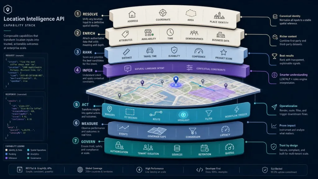
Anreicherung verbindet Koordinaten mit Kategorie, Adresse, Verfügbarkeit, Öffnungsstatus, Verwaltungsgebiet, ÖPNV, Reisezeit, demografischem oder ökologischem Kontext, Eigentümer/Mandant sowie Bestand oder Betriebsstatus. Die maßgebliche Quelle hängt vom Attribut ab: öffentliche Anbieter für Adressen, interne Systeme für Bestand, Zulässigkeit, Preis, Personal oder kontobezogenen Zugriff. Ranking ordnet eine Rohmenge nach Entfernung, Zeit, Kategorie, Verfügbarkeit, Präferenzen, Betriebsgebiet, Priorität, Aktualität, Vertrauen, Beliebtheit, Barrierefreiheit oder Produktscore. „Am nächsten“ ist nur eine Regel; „beste Eignung unter diesen Vorgaben“ ist Location Intelligence.
Inferenz übersetzt Sprache oder Anwendungskontext in räumliche Absicht: Immobilien nahe Nahverkehr und Supermarkt, Kliniken im Servicegebiet mit Laufkundschaft, Filialen mit Erfüllung vor 17 Uhr, ein Treffpunkt auf halbem Weg oder Anlagen in einer prognostizierten Überflutungszone. Sie erkennt Entitäten, Vorgaben, Geografie und Aktionen; Ergebnisse müssen gegen Quellsysteme validiert werden. Aktionserzeugung liefert strukturierte Karten- und Workflow-Operationen: Ausschnitt anpassen, Marker setzen/entfernen, Polygon hervorheben, Route zeichnen, Daten filtern, Ortsdetails öffnen, Navigation starten, Geschäftsworkflow auslösen oder menschliche Bestätigung anfordern.
Messung schließt den Kreis. Ereignisse umfassen eingereichte Fragen, aufgelöste Orte, Ergebnisse ohne Treffer, angewandte Kartenaktionen, angeforderte Routen, ausgewählte Resultate, akzeptierte Empfehlungen, gefilterte Gebiete, geteilte Karten und abgeschlossene Workflows. Analysen zeigen Nachfrage, Regionen ohne Ergebnisse, konvertierende Empfehlungen und Datenlücken. Governance begleitet alles: Autorisierung, Mandantentrennung, Quellenangabe, Aufbewahrung und Quoten verhindern einen unzulässigen Datenpfad.
Kaleidrs Platform API dokumentiert derzeit Streaming-Chat, Ortsanreicherung, Routenerstellung, Designanalyse, Stilkataloge und Designanwendung. Das Browser-SDK kann KI-Chat, Viewer, Editor oder gestaltete Basiskarten an eine Anwendung anbinden. Siehe Endpoint-Referenz, Entwicklerdokumentation, KI-Chatassistent zu einer interaktiven Karte hinzufügen und KI-Chat zu einer Karte hinzufügen.
Wie funktioniert die Architektur?
Die API liegt zwischen Produktabsicht und Geodiensten. Nutzer oder aufrufendes System äußern Frage, Anfrage, Ereignis oder Geschäftsentscheidung. Die Host-Anwendung besitzt Oberfläche, Identität, Mandantenkontext, Berechtigungen, Workflow und endgültige Aktion. Die Intelligence-Schicht interpretiert Absicht, wählt Fähigkeiten, kombiniert Belege, priorisiert und liefert strukturierte Aktionen. Geodienste liefern Geokodierung, Ortssuche, Routing, Kartendaten, Gelände, Bilder oder Feature-Abfragen. Geschäftssysteme bleiben für Bestand, Kunden, Anlagen, Zulässigkeit, Preise, Immobilien und Betrieb maßgeblich. Die Produktoberfläche zeigt Resultate in Karten, Listen, Dashboards, Chat, Alarmen oder Automatisierungen; Analysen erfassen Nutzung, Ergebnis, Geografie, Qualität und Geschäftswirkung.
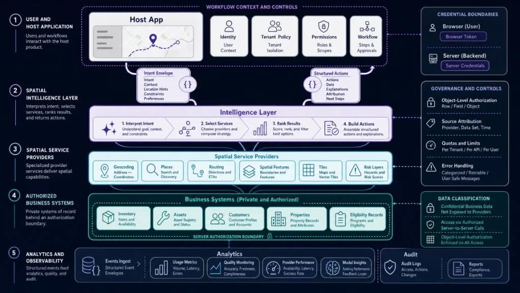
| Schicht | Verantwortung |
|---|---|
| Nutzer oder aufrufendes System | Äußert Frage, Anfrage, Ereignis oder Geschäftsentscheidung |
| Host-Anwendung | Besitzt Oberfläche, Identität, Mandantenkontext, Berechtigungen, Workflow und Endaktion |
| Intelligence-Schicht | Interpretiert Absicht, wählt Fähigkeiten, kombiniert Belege, priorisiert und liefert strukturierte Aktionen |
| Geodienste | Geokodierung, Ortssuche, Routing, Kartendaten, Gelände, Bilder oder Feature-Abfragen |
| Geschäftssysteme | Maßgeblicher Bestand, Kunden, Anlagen, Zulässigkeit, Preise, Immobilien und Betrieb |
| Karten-/Produktoberfläche | Zeigt Ergebnisse über Karten, Listen, Dashboards, Chat, Alarme oder Automatisierungen |
| Analyseschicht | Erfasst Nutzung, Ergebnis, Geografie, Qualität und Geschäftswirkung |
Die Architektur muss Eigentumsgrenzen bewahren: Die Host-Anwendung besitzt Nutzer und Geschäftsworkflow; Geodatenanbieter ihre vertraglich geregelten Daten und Dienste; die Intelligence-Schicht interpretiert und koordiniert; Geschäftssysteme bleiben für private Fakten maßgeblich. Die Oberfläche zeigt Ergebnisse und ermöglicht Erholung bei unvollständigen Antworten. Die W3C- und OGC-Empfehlungen für räumliche Daten im Web betonen Webarchitektur und klare Praktiken für Auffindbarkeit, Zugänglichkeit, Interoperabilität und Wiederverwendung—auch wenn ein Sprachmodell darüber liegt.
Wie sieht eine Location-Intelligence-Anfrage aus?
Eine Produktanfrage enthält oft mehr als einen Suchtext. Das folgende JSON ist konzeptionell und kein aktueller Kaleidr-Endpoint-Vertrag:
{
  "query": "Find eligible clinics within 20 minutes that accept walk-ins",
  "origin": {
    "type": "Point",
    "coordinates": [-77.0365, 38.8977]
  },
  "constraints": {
    "max_travel_minutes": 20,
    "walk_in": true,
    "tenant_id": "tenant_123"
  },
  "context": {
    "language": "en",
    "map_zoom": 11
  }
}
Eine entscheidungsfertige Antwort kann stabile IDs, Geometrien, Zulässigkeit, Scores, Gründe, erlaubte Aktionen und Quellen enthalten:
{
  "results": [
    {
      "id": "clinic_482",
      "geometry": {
        "type": "Point",
        "coordinates": [-77.021, 38.91]
      },
      "travel_minutes": 14,
      "eligible": true,
      "score": 0.91,
      "reasons": [
        "Inside service area",
        "Walk-ins accepted",
        "Open during requested period"
      ]
    }
  ],
  "actions": [
    {
      "type": "fit_bounds",
      "result_ids": ["clinic_482"]
    }
  ],
  "sources": [
    "authorized_clinic_directory",
    "approved_routing_service"
  ]
}
Das Schema variiert. Wichtig sind stabile IDs, Geometrien, Gründe, Quellen und erlaubte Aktionen—nicht ein unbelegter Absatz, den die Anwendung nachträglich parsen muss.
Wie stellt Kaleidr Spatial Intelligence bereit?
Kaleidr positioniert Enterprise als Infrastruktur mit Inferenz-APIs, Ranking, Analysen, Deployment-Support und skalierbaren APIs. Die Plattform trennt drei Scopes: ai für Chat, Inferenz und Abruf, maps für Basiskarten und Kacheln, design für Editor- und Designrouten. Ein Organisationsschlüssel hat zwei Laufzeitformen: einen veröffentlichbaren Browser-Schlüssel, den das SDK gegen eine kurzlebige origin-gebundene Sitzung tauscht, und einen Server-Schlüssel als Bearer im Backend. Die Authentifizierungsdokumentation erklärt, dass Server-Schlüssel per CORS im Browser gesperrt sind und veröffentlichbare Schlüssel über das SDK statt als rohe Bearer verwendet werden.
Ein Backend kann den dokumentierten Chat-Stream direkt aufrufen:
curl -N https://api.kaleidr.com/inference-api/b2b/v1/chat/control/stream \
  -H "X-Api-Key: YOUR_SERVER_API_KEY" \
  -H "Content-Type: application/json" \
  -H "Accept: text/event-stream" \
  -d '{
    "messages": [
      {
        "role": "user",
        "content": "cafes near the Louvre"
      }
    ]
  }'
Das Beispiel folgt der Endpoint-Dokumentation. Verwenden Sie Server-Schlüssel nur im Backend; Browseranwendungen nutzen einen veröffentlichbaren Schlüssel über kaleidr.js oder <kaleidr-map>.
Wo setzen Teams Location Intelligence ein?
Lokale Entdeckungs- und Empfehlungsprodukte interpretieren Absicht, finden Kandidaten, priorisieren sie und erklären Ergebnisse—wie im Leitfaden zur KI-gestützten lokalen Unternehmenssuche. Immobilienprodukte verbinden Angebote mit Reisezeit, Umgebung, Diensten, Schulen, Nahverkehr und Präferenzen. Einzelhandel wählt zulässige Filialen nach Bestand, Gebiet, Zeit, Öffnung, Kapazität und Fulfillment. Mobilität und Lieferung ordnen Anfragen Servicezonen zu, berechnen Routen, priorisieren Fahrer oder Anlagen und überwachen geografische Lücken.
Außendienstteams finden Anlagen, erkennen die Grenze eines Vorfalls, priorisieren Ressourcen und lösen Workflows aus. Risiko- und Umweltanwendungen vergleichen Anlagen mit Überflutung, Feuer, Wetter, Klima, Gelände oder anderen Ebenen, wobei Quelle und Zeitpunkt jedes Datensatzes klar bleiben müssen. SaaS- und Marktplatzprodukte ergänzen standortbezogene Suche, dialogische Karten, eingebettete Kartenerstellung oder gebrandete Raumerlebnisse, ohne jedes Teilsystem selbst zu bauen.
Wie unterscheidet sich eine Location-Intelligence-API von GIS?
Beide überlappen, sind aber nicht identisch. Ein GIS bietet meist breite Werkzeuge für Datenverwaltung, Kartografie, räumliche Analyse, Bearbeitung, Projektion und Fachworkflows. Eine API stellt ausgewählte Fähigkeiten über einen programmierbaren Vertrag bereit. Dahinter können GIS, räumliche Datenbank, Cloud-Dienste oder eine KI-Orchestrierung mehrerer APIs stehen. Bewerten Sie Vertrag, Daten, Genauigkeit, Latenz, Governance und Betrieb statt nur den Kategorienamen.
Nutzen Sie GIS für umfassende Arbeitsumgebungen von Analysten und Fachleuten; eine API für wiederholbare räumliche Fähigkeiten innerhalb eines Kunden- oder internen Produkts. Reife Systeme verwenden oft beides.
Selbst entwickeln, kaufen oder hybrid?
Es geht nicht nur darum, ob ein Team einen Endpoint schreiben kann. Ein Produktionsstack kann Orts- und Adressdaten, Geokodierung, Routing, räumliche Indizes, Feature-Speicher, Normalisierung, Entitätsauflösung, Ranking, Sprachinterpretation, Quellenangaben, Darstellung, Caching, Messung, Beobachtbarkeit, Datenschutz, regionale Bereitstellung und laufende Datenpflege erfordern.
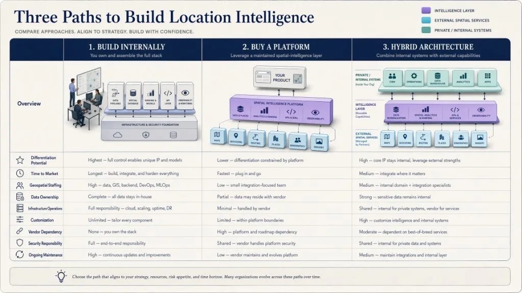
Intern bauen, wenn räumliche Logik Kern-IP ist, starke Geo-Engineering-Kompetenz besteht, einzigartige Daten nicht delegiert werden können, Leistung/Deployment spezialisiert sind und das Team Systeme langfristig betreiben kann. Kaufen/Partner wählen, wenn Markteinführungszeit zählt, Fähigkeiten üblich aber betrieblich komplex sind, ein Zugriffsmodell für KI, Karten und Design gewünscht ist, Spezialisten fehlen, Nutzung/Support Vertragsbedingungen brauchen oder gepflegte SDK/API helfen. Hybrid wählen, wenn interne Systeme Geschäftsfakten und Zulässigkeit besitzen, externe Anbieter Geokodierung, Routing, Karten oder Ortsdaten liefern, eine Plattform Inferenz und Interaktion koordiniert und die Host-App endgültig entscheidet. Hybrid ist üblich, weil Geschäftskontext und Standard-Geodienste andere Eigentums- und Pflegeprofile haben.
Wie bewertet man eine Location-Intelligence-API?
Prüfen Sie zuerst den Funktionsumfang—Geokodierung, Ortssuche, Filter, Routing, Ranking, Inferenz, Kartenaktionen, Kacheln/Darstellung, Analyse, Design/Editor—ohne vom Namen auf alles zu schließen. Fragen Sie dann nach Datenherkunft und Aktualität: Quelle je Attribut, Updatehäufigkeit, stabile IDs, Quellenangaben, Dubletten, Konflikte und Bedingungen für Speicherung/Wiederverwendung.
Bevorzugen Sie dokumentierte Schemas statt reine Prosa: IDs, Koordinaten, Geometrie, Vertrauen, Gründe, Quellen, Zeitstempel, Aktionstypen und explizite Fehler. OGC-API-Standards unterstützen interoperablen Feature-Zugriff, GeoJSON standardisierte Geometrie/Eigenschaften. Sicherheitsprüfung umfasst Browser-/Server-Schlüssel, Origin-/IP-Regeln, Objektberechtigung, Mandantentrennung, Rotation, Scopes, Auditlogs, Aufbewahrung, CORS und sensible Felder. Die OWASP API Security Top 10 nennt gebrochene Objektberechtigung als führendes Risiko; jede Abfrage mit nutzergesteuerter Objekt-ID muss auf Objektebene autorisieren.
Zuverlässigkeit umfasst Latenz je Endpoint/Region, Timeouts, Streaming-Unterbrechung, Wiederholungsregeln, Quoten, Parallelität, Status, SLA und Support. Kaleidr misst Nutzung derzeit organisationsweit statt je Schlüssel. Bei Monatsquote oder Parallelitätsgrenze gibt die API 429 zurück; Streams können Quoteninformationen liefern (Quoten und Limits). Entwicklererfahrung umfasst präzise Endpoints, Versionierung, Beispiele, SDK, OpenAPI bzw. maschinenlesbare Beschreibung, Fehlersemantik, Testumgebung, Changelog und Migrationspolitik. Die OpenAPI Specification ist sprachneutral und unterstützt Dokumentation, Clientgenerierung, Tests und Werkzeuge. Auch ohne vollständiges OpenAPI senken präzise Verträge und Versionierung das Risiko.
Kommerziell sind Messeinheit, organisationsweite Pools, getrennte Kosten für KI/Karten/Routing/Kacheln, Parallelität, Überschreitungen, Mindestverträge, Support, Egress und weitergereichte Anbieterpreise zu klären. Kaleidrs aktuelle Preisliste nennt Pro für 29 USD pro Monat mit Entwickler-API, Schlüsseltypen, Embeds und Organisationspool. Enterprise ist individuell mit Nutzung, Verträgen, SLA, Support und unabhängigen CDN-Optionen. Preise wurden am 24. Juli 2026 geprüft und müssen vor Kauf neu geprüft werden.
Wie werden private Standortdaten geregelt?
Standort kann sensibel werden, auch wenn kein einzelnes Feld sensibel wirkt. Wiederholte Koordinaten, Bewegungen, Wohn-/Arbeitsmuster, Servicenutzung, Immobilien- oder Adressdaten können Identität und Verhalten offenlegen. Definieren Sie Zweck, Einwilligung/Rechtsgrundlage, Aufbewahrung, Genauigkeitsreduktion, Mandantentrennung, Region, Rollen, Audit, Löschung, Vorfälle und Modell-/Anbietergrenzen. Senden Sie nicht standardmäßig eine ganze Kunden- oder Betriebsdatenbank an Inferenz. Rufen Sie nach Autorisierung nur erlaubte Datensätze ab, übermitteln Sie erforderliche Felder und halten Sie die endgültige Geschäftsaktion in der Policy-Schicht der Host-App. Die API soll eine erlaubte Entscheidung unterstützen, nicht die Autorisierung umgehen.
Welche Ereignisse und Kennzahlen zählen?
Die folgenden Namen sind redaktionelle Empfehlungen, keine Behauptung über automatisch gesendete Kaleidr-Analytics-Ereignisse:
location_request_submitted
location_intent_resolved
location_candidates_returned
location_no_result
location_result_selected
location_action_applied
route_requested
service_area_matched
location_api_error
location_api_quota_reached
location_workflow_completed
Nützliche Kennzahlen sind Intent-Auflösungsrate, erfolgreiche Ortsauflösung, Keine-Treffer- und Dublettenrate, Median- und Tail-Latenz, Ranking-Akzeptanz, Routen-/Aktionsabschluss, Quellenabdeckung, geografische Lücken, Kosten je Workflow, regionale Konversion und Wiederholungsnutzung aktivierter Konten. Die North-Star-Kennzahl ist selten „API-Aufrufe“. Messen Sie die abgeschlossene Nutzer- oder Geschäftsaufgabe.
Welche Fehler sollten Teams vermeiden?
| Fehler | Folge | Empfohlene Korrektur |
|---|---|---|
| Koordinaten als vollständige Intelligenz behandeln | Kontext, Vorgaben und Zulässigkeit fehlen | Geometrie mit maßgeblichen Attributen und Rankingregeln verbinden |
| Ortsnamen aus Prosa parsen | Ergebnisse sind fragil | Strukturierte Ortsobjekte mit stabilen IDs/Geometrien |
| „Am nächsten“ als „am besten“ annehmen | Ergebnis kann unpassend sein | Gegen das gesamte Produktziel priorisieren |
| Öffentliche und private Fakten mischen | Maßgebliches System bleibt unklar | Quellen kennzeichnen, Grenzen bewahren |
| Server-Schlüssel an Browser senden | Bearer wird öffentlich | Browserfähige Schlüssel oder Host-Backend |
| Objektberechtigung überspringen | Fremde Mandantendaten abrufbar | Jedes Objekt und jede Raumabfrage autorisieren |
| Koordinatenreihenfolge ignorieren | Punkte erscheinen falsch | Format beachten; GeoJSON nutzt Länge, Breite |
| Quotenverhalten verstecken | Produktion fällt unerwartet aus | Nutzung überwachen und 429 behandeln |
| Aufrufe statt Ergebnisse messen | Nutzung wird mit Wert verwechselt | Entscheidungen und Workflows verfolgen |
| Einen Anbieter als Quelle aller Fakten behandeln | Qualität und Lizenz unklar | Maßgebliche Quelle je Attribut festlegen |
Abschließende Prüfliste
- Nutzerentscheidung oder Workflow definiert
- Erforderliche räumliche Fähigkeiten aufgeführt
- Quelle jedes Attributs identifiziert
- Stabile Orts-/Feature-IDs verfügbar
- Geometrieformat und Koordinatenreihenfolge bestätigt
- Rankinglogik dokumentiert
- Inferenz von Faktenvalidierung getrennt
- Browser- und Server-Schlüssel getrennt
- Objekt- und Mandantenautorisierung umgesetzt
- Strukturierte Fehler und leere Zustände behandelt
- Quoten und Parallelität getestet
- Latenz unter realistischer Geografie/Last gemessen
- Aufbewahrung und Regionen geprüft
- Analysen an abgeschlossene Workflows gebunden
- Anbieterbedingungen und Weitergabekosten geprüft
- Versionierungs- und Migrationspolitik geprüft
- Echte Nutzeranfragen getestet
- Menschliche Eskalation für folgenreiche Entscheidungen definiert
Fazit
Eine Location-Intelligence-API ist mehr als ein Karten-Endpoint. Sie verwandelt Orte, Koordinaten, Routen, Features, Geschäftsdaten und Nutzerabsicht in strukturierte Entscheidungen oder Aktionen. Geokodierung beantwortet, wo eine Adresse liegt; Ortssuche liefert Kandidaten; Routing berechnet Wege; Rendering zeigt Resultate. Location Intelligence koordiniert dies mit Ranking, Inferenz, Geschäftsregeln und Analyse.
Die richtige Architektur wahrt Grenzen: Das Host-Produkt besitzt Workflow und Autorisierung, Quellsysteme die Fakten, Geodienste ihre vertraglichen Leistungen und die Intelligence-Schicht interpretiert Kontext und liefert strukturierte Ergebnisse. Intern bauen bei Kern-IP, kaufen bei standardisierter Infrastruktur, hybrid arbeiten, wenn privater Geschäftskontext im Host bleiben muss.
Integrieren Sie Location Intelligence in Ihr Produkt
Nutzen Sie Kaleidrs Inferenz-APIs, Ranking, Analysen, SDK und Kartenprodukte, ohne Ihren übrigen Stack zu ersetzen. Erkunden Sie Enterprise für Deployment, Nutzungsverträge und Infrastruktur für Host-Produkte mit eigenem Workflow und Autorisierungsmodell.
Platform API prüfen
Lesen Sie vor der Auswahl des Integrationswegs Authentifizierung, Scopes, Endpoints, Quoten, Fehler- und SDK-Dokumentation. Die Entwicklerdokumentation ist der maßgebliche Vertrag für Schlüssel, Streaming-Chat und Kartenprodukte.
Häufig gestellte Fragen
Was ist eine Location-Intelligence-API?
Eine programmierbare Schnittstelle, die Geodaten, Standortdienste, Kontext, Ranking, Geschäftsregeln und teilweise KI-Inferenz zu entscheidungsfertigen Orten, Aktionen oder Erkenntnissen verbindet und einzelne Geokodierungs-, Such-, Routing- oder Kartenendpoints koordiniert.
Wie unterscheidet sie sich von einer Geokodierungs-API?
Geokodierung wandelt Adressen/Beschreibungen in Koordinaten und zurück. Location Intelligence ergänzt Kontext, Anreicherung, Ranking, Beziehungen, Geschäftsbedingungen und Aktionen, damit das Produkt eine Entscheidung statt nur Koordinaten erhält.
Ist eine Karten-API dasselbe?
Nein. Eine Karten-API rendert Karte und Ebenen; Location Intelligence entscheidet anhand von Geografie und Kontext, was die Anwendung zeigen oder tun sollte. Produkte können beides bündeln, die Aufgaben bleiben verschieden.
Welche Datenformate werden verwendet?
JSON ist üblich; GeoJSON standardisiert geografische Features und Geometrie. Hinzu kommen Vektorkacheln, codierte Polylinien, Protocol Buffers, CSV, KML oder Anbieterschemas. Dokumentierte Schemas mit stabilen IDs sind Prosa vorzuziehen.
Was kann die API für ein Unternehmen leisten?
Lokale Suche, Immobilien, Filialauswahl, Servicegebiete, Routing, Anlagenbetrieb, Risikoanalyse, Gebietsplanung, Empfehlungen und eingebettete Karten. Wert entsteht, wenn Geografie eine Produktentscheidung ändert—nicht nur eine Karte angezeigt wird.
Ist KI erforderlich?
Nein. Deterministische Raumanalyse, Regeln, Ranking und Anreicherung reichen oft. KI hilft bei Sprache, flexiblen Vorgaben, Erklärungen und komplexen Aktionen; Faktenvalidierung bleibt von Inferenz getrennt.
Kann sie private Geschäftsdaten nutzen?
Ja, mit expliziter Autorisierung, Mandantentrennung, kontrolliertem Abruf, Quellenverantwortung, Aufbewahrungsregeln und Auditierbarkeit. Private Daten bleiben unter Governance der Host-Organisation.
Sollte sie Prosa oder strukturierte Daten liefern?
Produktions-APIs sollten strukturierte Orte, Geometrien, IDs, Scores, Quellen, Aktionen und Fehler liefern. Prosa verbessert die UX, darf aber nicht zum Parsen kritischer Fakten zwingen.
Welche Sicherheitskontrollen sind am wichtigsten?
Browser-/Server-Schlüssel trennen, Origins/IPs beschränken, Objekt- und Mandantenautorisierung erzwingen, Scopes begrenzen, Schlüssel rotieren, Standortverlauf schützen, Aufbewahrung definieren und Zugriffe prüfen. Gebrochene Objektberechtigung ist ein führendes OWASP-Risiko.
Wie misst man die API?
Erfolgreiche Auflösungen, akzeptierte Rankings, Kartenaktionen, Workflowabschluss, Latenz, Keine-Treffer-Raten, Abdeckung, Kosten pro Ergebnis und Konversion. Anfragevolumen allein misst keinen Nutzen.
Wie passt Kaleidr in den Stack?
Kaleidr bietet Spatial-Intelligence-Infrastruktur mit KI-Chat und Inferenz, Ortsabruf, Ranking, gestalteten Karten/Kacheln, Editor/Viewer, Analysen und Enterprise-Support. Die Host-App bleibt für Nutzer, Berechtigungen, Regeln und private Daten verantwortlich.
Quellen
- Esri. What is Location Intelligence? Abgerufen am 24. Juli 2026. https://www.esri.com/en-us/location-intelligence/overview
- Google. Geocoding API overview. Google Maps Platform documentation. Abgerufen am 24. Juli 2026. https://developers.google.com/maps/documentation/geocoding/guides-v3/overview
- IETF. RFC 7946: The GeoJSON Format. Abgerufen am 24. Juli 2026. https://datatracker.ietf.org/doc/html/rfc7946
- Kaleidr. Auth & scopes. Kaleidr Developer Docs. Abgerufen am 24. Juli 2026. https://docs.kaleidr.com/platform-api/auth-and-scopes
- Kaleidr. Endpoints. Kaleidr Developer Docs. Abgerufen am 24. Juli 2026. https://docs.kaleidr.com/platform-api/endpoints
- Kaleidr. Errors. Kaleidr Developer Docs. Abgerufen am 24. Juli 2026. https://docs.kaleidr.com/reference/errors
- Kaleidr. Get an API key. Kaleidr Developer Docs. Abgerufen am 24. Juli 2026. https://docs.kaleidr.com/get-an-api-key
- Kaleidr. Introduction. Kaleidr Developer Docs. Abgerufen am 24. Juli 2026. https://docs.kaleidr.com
- Kaleidr. Location Intelligence API & Spatial Infrastructure. kaleidr.com. Abgerufen am 24. Juli 2026. https://kaleidr.com/enterprise
- Kaleidr. Pricing & Plans. kaleidr.com. Abgerufen am 24. Juli 2026. https://kaleidr.com/pricing
- Kaleidr. Quota & rate limits. Kaleidr Developer Docs. Abgerufen am 24. Juli 2026. https://docs.kaleidr.com/platform-api/quota-and-rate-limits
- Mapbox. API Docs. Abgerufen am 24. Juli 2026. https://docs.mapbox.com/api/guides/
- Mapbox. Directions API. Abgerufen am 24. Juli 2026. https://docs.mapbox.com/api/navigation/directions/
- Mapbox. Understanding the Geocoding API. Abgerufen am 24. Juli 2026. https://docs.mapbox.com/help/dive-deeper/geocoding/
- OGC. OGC API – Features Standard. Abgerufen am 24. Juli 2026. https://www.ogc.org/standards/ogcapi-features/
- OpenAPI Initiative. The OpenAPI Initiative. Abgerufen am 24. Juli 2026. https://www.openapis.org/
- OWASP. OWASP Top 10 API Security Risks – 2023. Abgerufen am 24. Juli 2026. https://owasp.org/API-Security/editions/2023/en/0x11-t10/
- W3C and OGC. Spatial Data on the Web Best Practices. Abgerufen am 24. Juli 2026. https://www.w3.org/TR/sdw-bp/
@misc{esri_location_intelligence,
  title  = {What is Location Intelligence?},
  author = {{Esri}},
  note   = {Accessed 24 July 2026},
  url    = {https://www.esri.com/en-us/location-intelligence/overview}
}

@misc{ogc_api_features,
  title  = {OGC API -- Features Standard},
  author = {{Open Geospatial Consortium}},
  note   = {Accessed 24 July 2026},
  url    = {https://www.ogc.org/standards/ogcapi-features/}
}

@misc{ietf_geojson,
  title  = {RFC 7946: The GeoJSON Format},
  author = {{Internet Engineering Task Force}},
  note   = {Accessed 24 July 2026},
  url    = {https://datatracker.ietf.org/doc/html/rfc7946}
}

@misc{kaleidr_endpoints,
  title  = {Endpoints},
  author = {{Kaleidr}},
  note   = {Kaleidr Developer Docs; accessed 24 July 2026},
  url    = {https://docs.kaleidr.com/platform-api/endpoints}
}

@misc{kaleidr_auth_scopes,
  title  = {Auth \& scopes},
  author = {{Kaleidr}},
  note   = {Kaleidr Developer Docs; accessed 24 July 2026},
  url    = {https://docs.kaleidr.com/platform-api/auth-and-scopes}
}

@misc{kaleidr_enterprise,
  title  = {Location Intelligence API \& Spatial Infrastructure},
  author = {{Kaleidr}},
  note   = {Accessed 24 July 2026},
  url    = {https://kaleidr.com/enterprise}
}

@misc{owasp_api_security,
  title  = {OWASP Top 10 API Security Risks -- 2023},
  author = {{OWASP}},
  note   = {Accessed 24 July 2026},
  url    = {https://owasp.org/API-Security/editions/2023/en/0x11-t10/}
}