
يجمع رسم الخرائط بالذكاء الاصطناعي بين الذكاء الاصطناعي والخرائط والبيانات الجغرافية المكانية والبرمجيات المدركة للموقع. ويمكنه فهم الأسئلة، وإنشاء خريطة تفاعلية أو إعادة تصميمها، وتصنيف الصور، والتنبؤ بالأنماط المكانية، وترتيب الأماكن، وتحسين المسارات، وأتمتة إجراءات الخريطة. تظل الخريطة هي الواجهة الجغرافية، بينما يساعد الذكاء الاصطناعي في فهم المقصد وتحديد ما ينبغي عرضه أو تنفيذه. وتظل البيانات الموثوقة والسياق الواضح والاختبار والمراجعة البشرية ضرورية.
يعرّف هذا الدليل الفئة وأنواعها الستة وسير العمل الشائع، ويقارنها بنظم GIS ومولدات الخرائط، ثم يناقش القيمة والحدود والحوكمة والتقييم وموقع Kaleidr.
لمحة سريعة
- فئة وليست ميزة واحدة: تشمل المحادثة والإنشاء وGeoAI وتحليل الصور والترتيب والعمليات.
- ابدأ بالمهمة: اختر النظام وفق العمل الجغرافي لا الاسم التسويقي.
- نتائج موثقة: المعرّفات والهندسة والمصادر والأسباب والثقة أهم من النص البليغ.
- مسؤولية بشرية: تظل البيانات والصلاحيات والتراخيص وإتاحة الوصول والمراجعة مسؤولية المنتج.
- تركيز Kaleidr: تجارب تفاعلية عبر Spatial AI وStudio وتضمينات المطورين وAnalytics وواجهات Enterprise.
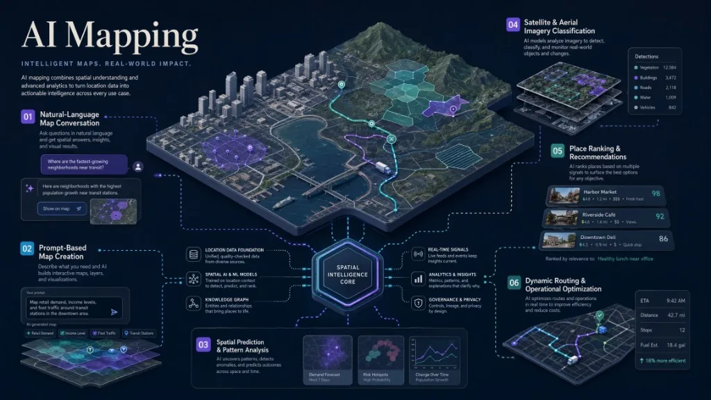
ما رسم الخرائط بالذكاء الاصطناعي؟
هو استخدام الذكاء الاصطناعي لإنشاء المعلومات الجغرافية أو تحليلها أو تفسيرها أو البحث فيها أو تحديثها أو التفاعل معها. ويشمل معالجة اللغة الطبيعية، والتعلم الآلي المكاني، والرؤية الحاسوبية، ونماذج ترتيب الأماكن، والذكاء التوليدي للمحتوى والتصميم، وتحسين المسارات ومناطق الخدمة.
تعرّف Esri GeoAI بأنه دمج الذكاء الاصطناعي مع البيانات والعلوم والتقنيات الجغرافية المكانية. وتذكر وثائق ArcGIS Pro التصنيف والتجميع والتنبؤ واستخراج المعالم وتحليل الصور والنصوص، مع التأكيد على ضرورة فهم المحللين للمشكلة والبيانات والحدود. وتصف NASA Earthdata الذكاء الاصطناعي بأنه أداة لاكتشاف العلاقات في مجموعات رصد الأرض الكبيرة. راجع What Is GeoAI? وGeoAI in ArcGIS Pro وEarth Observation Data and Artificial Intelligence. وفي المنتجات يشمل ذلك سؤال الخريطة والإنشاء من مطالبة والمساعد المكاني المضمّن.
ماذا تعني «خريطة مزودة بالذكاء الاصطناعي»؟
هي خريطة تفاعلية أو سير عمل مكاني يسهم فيه الذكاء الاصطناعي قبل العرض أو أثناء الإنشاء أو التفاعل أو التحليل أو بعد الاستخدام. وقد يستخرج الطرق والمباني، وينشئ البنية والأسلوب، ويفهم السؤال، ويتحكم في الكاميرا والعلامات والمرشحات، ويتنبأ بالتغير أو يقترح تحسينات.
لذلك قد تعرض نتائج “AI mapping” صور خرائط خيالية ثابتة أو تحليل أقمار صناعية أو GeoAI احترافية أو مساعدين لـMapbox وGoogle Maps وMapLibre. والسؤال الأول هو: ما المهمة الجغرافية التي ينبغي أن ينفذها الذكاء الاصطناعي؟
ما الأنواع الستة الرئيسية؟
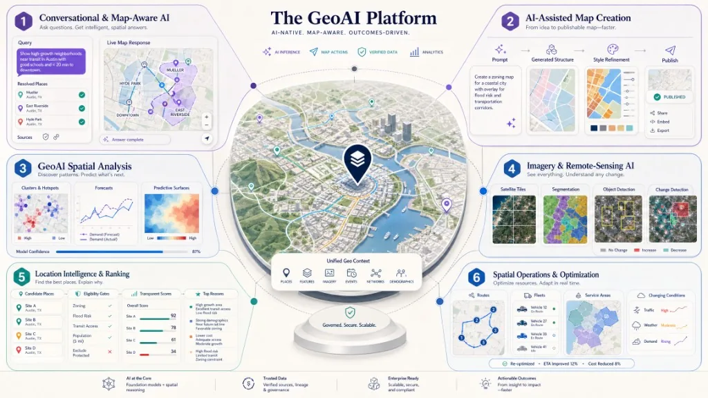
الذكاء الحواري والمدرك للخريطة
يمكن للمستخدم طلب مكتبات قرب مؤتمر، أو عقارات داخل منطقة بزمن رحلة أقصر، أو مواقع خدمة مؤهلة. يعيد المساعد المدرك للخريطة أماكن منظمة، ويضيف علامات، ويضبط مجال العرض، ويبرز منطقة أو يبدأ إجراءً؛ أما الحديث وحده فيترك العمل الجغرافي للمستخدم.
في الإنتاج، يملك التطبيق المضيف المستخدمين والصلاحيات وسير العمل والقواعد والواجهة، وتفسر طبقة الذكاء المقصد، ويدير محرك الخريطة الكاميرا والطبقات، وتحل خدمات الموقع الأماكن والترميز الجغرافي والمسارات، وتظل أنظمة الأعمال مرجع المخزون والتوافر والأهلية. ولا ينبغي أن يكون المساعد مصدر الحقيقة للعناوين أو الأسعار أو القرارات المنظمة.
توثق Kaleidr ربط الدردشة بخرائط Mapbox وGoogle Maps وMapLibre الحالية. راجع وثائق المطورين وكيفية إضافة دردشة بالذكاء الاصطناعي إلى الخريطة.
إنشاء الخرائط وتصميمها بمساعدة الذكاء الاصطناعي
تحدد المطالبة الجيدة الغرض والمنطقة والجمهور والفئات والتسلسل البصري والعلامة التجارية والتفاعلات ووجهة النشر. ينشئ الذكاء الاصطناعي مسودة أولى، لكن المؤلف يراجع الدقة والمحتوى والتسميات والأنماط والطبقات والجوال والإسناد وإتاحة الوصول.
يستخدم Kaleidr Studio مسار Prompt → Process → Refine → Deploy مع خرائط أساس و3D وبيانات حية وطبقات قابلة لإعادة الاستخدام وأنماط العلامة. راجع Kaleidr Studio ومنشئ الخرائط التفاعلية بالذكاء الاصطناعي.
GeoAI للتحليل والتنبؤ المكاني
يطبق التعلم الآلي على اكتشاف التجمعات والشذوذ والتصنيف والتنبؤ المكاني والتغير الزمني والمخاطر وتخصيص الموارد، ويمكنه تمثيل المسافة والتجاور والشكل والاحتواء والشبكات مباشرة. ولا يلغي ذلك الحاجة إلى التحليل المتأني؛ راجع GeoAI in ArcGIS Pro.
ذكاء الصور والاستشعار عن بُعد
يستخرج معلومات من الأقمار الصناعية والطائرات والمسيّرات والفيديو والليدار وأجهزة الاستشعار، مثل الغطاء الأرضي والمباني والطرق والمحاصيل والحرائق والفيضانات والنباتات والأجسام والتغيرات. راجع Earth Observation Data and Artificial Intelligence وFundamentals of Machine Learning for Earth Science. ويجب تقييم الدقة والسحب والمستشعر والتسميات والزمن وقابلية النقل بين المناطق.
ذكاء الموقع والترتيب والتوصية
يجمع السياق الجغرافي وقواعد الأعمال لترتيب المواقع حسب المسافة وزمن الرحلة وساعات العمل والتفضيلات والتوافر ومنطقة الخدمة وحداثة البيانات والثقة وإتاحة الوصول. «الأقرب» قاعدة واحدة؛ أما «أفضل نتيجة مؤهلة ضمن القيود» فمسألة أوسع.
يوفر Kaleidr Enterprise الاستدلال والترتيب والتحليلات ودعم النشر. راجع Kaleidr Enterprise وما واجهة API لذكاء الموقع؟. ويحفظ الترتيب المسؤول أسباباً منظمة، ويفصل الأهلية الصارمة عن الملاءمة المرنة، ويحدد مصدر كل عامل.
العمليات المكانية والتحسين والخرائط الديناميكية
تشمل التوجيه والإرسال والأساطيل والأصول ومناطق التسليم والاستجابة للطوارئ وتوزيع المنشآت والأقاليم والتحديث الحي. ولا يحتاج كل ذلك إلى ذكاء توليدي؛ فقد يكون التوجيه الحتمي وقواعد البيانات المكانية وبحوث العمليات وقواعد الأعمال أفضل.
كيف يعمل رسم الخرائط بالذكاء الاصطناعي؟
تتبع أنظمة كثيرة مساراً مشتركاً من المقصد الجغرافي إلى نتيجة قابلة للقياس. وهذا نمط معماري لا ادعاء بأن جميع المزودين يعرضون الواجهات نفسها.
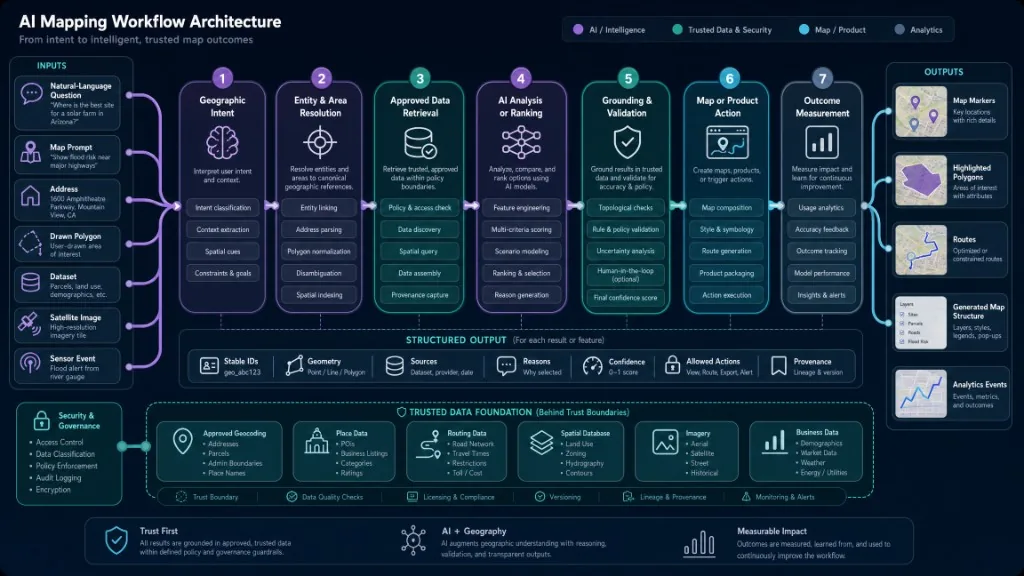
يتلقى النظام سؤالاً أو مطالبة أو عنواناً أو إحداثية أو مضلعاً أو بيانات أو صورة أو حدث مستشعر أو نطاق الخريطة، ثم يحل الأماكن والمناطق والمسارات والفئات والشروط الزمنية والعلاقات والأسماء الملتبسة. يحتاج “Springfield” إلى إزالة الالتباس، و«قرب المطار» إلى تعريف القرب، و«داخل هذه المنطقة» إلى هندسة صالحة.
يسترجع التطبيق، ضمن الصلاحيات والتراخيص وقواعد الحداثة والتخزين، بيانات الترميز الجغرافي والأماكن والمسارات والمعالم والصور وقواعد البيانات المكانية وأنظمة الأعمال والبيانات العامة. ثم تحلل النماذج أو تستدل أو ترتب، مع تطبيق القيود الصارمة قبل التوصيات المرنة.
يربط التوثيق الادعاءات بالسجلات والإحداثيات والمصادر والتوقيت والثقة. وتحفظ النتيجة المعرّف والهندسة والسمات والأسباب وعدم اليقين والإجراءات المسموح بها، ثم تتحول إلى علامات أو مسارات أو مناطق أو مرشحات أو قوائم أو تنبيهات أو سير عمل أو إجابات.
من الأحداث المفيدة:
ai_map_question_submitted, ai_map_answer_returned, ai_map_no_result, ai_map_action_applied, ai_map_result_selected, ai_map_created, ai_map_refined, ai_map_published, ai_map_shared, and ai_map_workflow_completed
هذه أسماء تحريرية مقترحة، وليست ادعاءً بأن Kaleidr Analytics ينشئها تلقائياً. ويجب ربط كل حدث بمهمة جغرافية مكتملة.
كيف يختلف عن GIS؟
| مجال المقارنة | GIS | رسم الخرائط بالذكاء الاصطناعي |
|---|---|---|
| الغرض | إدارة المعلومات الجغرافية وعرضها وتحريرها وتحليلها | تطبيق الذكاء الاصطناعي على الإنشاء والتفاعل والاستخراج والتحليل والقرار |
| المستخدمون | محللو GIS والمخططون والباحثون والعمليات والمطورون | المحللون والمطورون وفرق المنتجات والمنشئون والمستخدمون |
| الأساليب | قواعد مكانية وتراكبات وشبكات ومعالجة جغرافية وخرائط وإحصاء | لغة طبيعية وتعلم آلي وعميق ورؤية وترتيب وذكاء توليدي وتحسين |
| المخرجات | خرائط وبيانات وتحليلات ونماذج ولوحات | خرائط مولدة وتنبؤات وتصنيفات وتوصيات ودردشة وإجراءات |
| العلاقة | يوفر البيانات والأدوات وبيئة التحليل | يعمل داخل GIS أو فوق خدماته أو في منتج |
قد يشغّل GIS سير عمل للذكاء الاصطناعي، وقد يستخدم منتج AI خدمات جغرافية دون عرض واجهة GIS كاملة. وكثير من الأنظمة يجمعهما.
كيف يختلف عن مولد خرائط بالذكاء الاصطناعي؟
قد يعني المصطلح صورة ثابتة شبيهة بالخريطة أو منتجاً جغرافياً تفاعلياً.
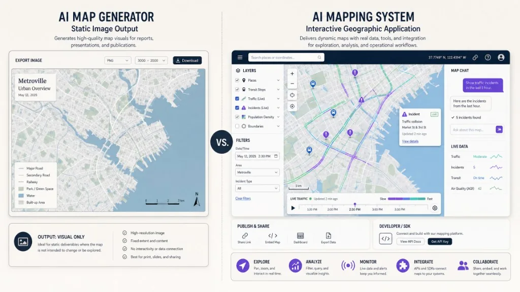
| القدرة | مولد صورة ثابتة | نظام تفاعلي |
|---|---|---|
| الناتج | صورة نقطية أو رسم | واجهة جغرافية وظيفية |
| الإحداثيات | زخرفية أو تقريبية | كائنات وإحداثيات جغرافية |
| التحريك والتكبير | لا | نعم |
| البحث والمرشحات | لا | ممكن |
| البيانات الحية | لا | ممكن |
| إجراءات الخريطة | لا | علامات وحدود وطبقات ومسارات وإبراز |
| النشر | تنزيل صورة | رابط أو عارض أو موقع أو SDK أو تطبيق |
| التحديث | إعادة إنشاء الصورة | تحديث المحتوى أو البيانات أو النمط أو التفاعل |
| الأنسب | رسوم إبداعية أو خرائط خيالية | سفر وأعمال وتحليلات وعمليات واكتشاف وتضمين |
صُمم Kaleidr Studio لإنشاء خرائط تفاعلية لا صور ثابتة؛ راجع Kaleidr Studio.
ما علاقته بذكاء الموقع؟
رسم الخرائط بالذكاء الاصطناعي هو المظلة الأوسع، بينما يركز ذكاء الموقع على القرارات المفيدة من السياق الجغرافي. وفي المنتجات الحديثة يتحول مقصد المستخدم إلى نتيجة منظمة ثم إلى إجراء ظاهر على الخريطة.
أين يصنع قيمة؟
يدعم السياحة الاكتشاف ومسارات الرحلة؛ راجع كيفية إنشاء خريطة سياحية بالذكاء الاصطناعي. وتجمع العقارات المرشحات والمناطق وزمن الرحلة، ويضيف البيع بالتجزئة الساعات والمخزون والأهلية، وتستخدم الخدمات اللوجستية المسارات والإرسال، وتصنف البيئة الأرض وترصد التغير. ويمكن للخدمات العامة تخصيص الموارد تحت الإشراف البشري، ولمنتجات SaaS تضمين الدردشة والعارض والترتيب دون بناء كل المكونات.
ما الذي لا يستبدله؟
لا يستبدل البيانات المرجعية أو الترميز الجغرافي أو التوجيه أو محرك الخريطة أو التراخيص والإسناد أو الصلاحيات أو قواعد البيانات أو منطق التطبيق أو إتاحة الوصول أو الأمن أو مراجعة البشر أو خبرة المجال أو تقييم النموذج. فالخريطة المقنعة قد تجعل الخطأ أكثر تصديقاً، ولذلك تحتاج إلى توثيق أقوى.
كيف نعالج الدقة والتحيز والحوكمة؟
تشمل المخاطر أماكن مختلقة، وبيانات قديمة، وفجوات التغطية، وتدريباً متحيزاً، وتفاوتاً إقليمياً، ومواقع حساسة، وحدوداً غير دقيقة، وترتيب إحداثيات خاطئاً، وتجميعاً مضللاً، ومتغيرات بديلة غير مناسبة، ونماذج صور تفشل في ظروف جديدة.
يعامل إطار NIST لإدارة مخاطر الذكاء الاصطناعي المخاطر طوال دورة الحياة. وتشمل الضوابط تحديد مصدر موثوق لكل سمة، وحفظ المعرّف والهندسة والمصدر والتحديث، وفصل الأهلية عن الترتيب، والاختبار حسب المنطقة واللغة والجهاز، وحماية سجل الموقع، وفصل بيانات الاعتماد، وتوفير التصحيح والتصعيد البشري، وإعادة التحقق عند تغير الظروف.
تدعم المعايير المفتوحة قابلية التشغيل البيني؛ راجع معايير OGC ومجموعة عمل الذكاء الاصطناعي في المعلوماتية الجغرافية.
كيف تقيّم منصة AI Mapping؟
ابدأ بالمخرج المطلوب: صورة أو خريطة تفاعلية أو تحليل أو تنبؤ أو إجابة أو مكوّن أو API أو إجراء عمل. تحقق من ملكية البيانات وأمان البيانات الخاصة والمعرّفات والمصادر والتحديث والتخزين وإعادة التوزيع. وفضّل الأماكن والهندسة والأسباب والإجراءات المنظمة.
راجع محركات الخرائط وSDK المتصفح والواجهات والعارض والمحرر وخرائط الأساس والبلاطات والمصادقة وقيود المصدر والوصول من الخادم والإصدارات والأخطاء. اختبر أسئلة وبيانات ومناطق وحالات فشل حقيقية، وقِس اختيار المكان وإنشاء الخريطة وإكمال المسار والتحليل والنشر وسير العمل، لا عدد المطالبات والاتصالات فقط.
أين تندرج Kaleidr؟
تحول Kaleidr رسم الخرائط بالذكاء الاصطناعي إلى تجارب تفاعلية، بينما يحتفظ التطبيق المضيف بالمستخدمين والصلاحيات وسير العمل والبيانات المرجعية.
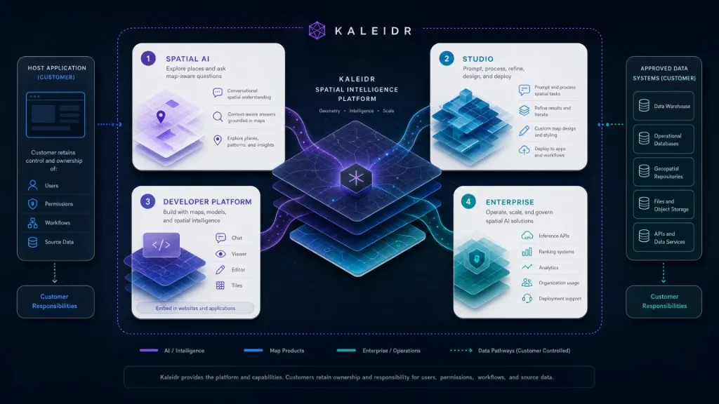
يدعم Kaleidr Spatial AI استكشاف الأماكن والإنشاء والتخصيص والمشاركة والقوالب. ويستخدم Kaleidr Studio مسار Prompt → Process → Refine → Deploy للخرائط والطبقات و3D والبيانات الحية والعلامة. وتوفر منصة المطورين SDK ودردشة وعوارض ومحررات وبلاطات لـMapbox وGoogle Maps وMapLibre، فيما يوفر Kaleidr Enterprise الاستدلال والترتيب وAnalytics والنشر.
كيف تبدأ مع Kaleidr؟
استكشف Spatial AI، وأنشئ وانشر في Studio، وأدمج الدردشة أو العارض عبر SDK، وقِس النتائج. وقيّم Enterprise للتكامل الخاص والاستخدام المخصص والعقود أو SLA. في 28 يوليو 2026 كانت خيارات Free وPro وEnterprise منشورة، وكان Pro بسعر 29 دولاراً شهرياً. راجع صفحة الأسعار المباشرة.
الخلاصة
رسم الخرائط بالذكاء الاصطناعي عائلة من الأنظمة للإنشاء الجغرافي والتفاعل والتحليل والصور والترتيب والعمليات. ويظل العقد الأقوى واضحاً: يفسر الذكاء الاصطناعي وينسق، وتتحقق الأنظمة الموثوقة من الحقائق، وتُظهر الخريطة الجغرافيا، وتقيس Analytics إنجاز المهمة المفيدة.
استكشف AI Mapping مع Kaleidr
اطرح أسئلة في Spatial AI، وأنشئ خريطة وانشرها في Studio، أو راجع وثائق الدردشة والعوارض والمحررات وخرائط الأساس والمصادقة والواجهات. جرّب Kaleidr Spatial AI أو ابدأ في Kaleidr Studio أو اقرأ وثائق المطورين.
الأسئلة الشائعة
ما رسم الخرائط بالذكاء الاصطناعي؟
هو استخدام AI لإنشاء المعلومات الجغرافية وتحليلها وتفسيرها والبحث فيها وتحديثها والتفاعل معها.
ما الخريطة المزودة بالذكاء الاصطناعي؟
خريطة تفاعلية يسهم فيها AI بفهم السؤال أو إنشاء المسودة أو تحليل الأنماط أو تصنيف الصور أو ترتيب المواقع أو تنفيذ الإجراءات.
هل هو نفسه GeoAI؟
GeoAI جزء مهم للتحليل والتنبؤ والتصنيف والاستخراج، أما المفهوم الأوسع فيشمل المحادثة والإنشاء بالمطالبة والمساعدين والتوصيات.
هل هو نفسه GIS؟
لا. يدير GIS المعلومات الجغرافية ويحللها ويحررها ويعرضها، بينما يطبق AI Mapping تقنيات الذكاء الاصطناعي على المهام الجغرافية.
هل يستطيع AI إنشاء خريطة تفاعلية؟
نعم، لكن على المؤلف التحقق من المواقع والبيانات والتسميات والأسلوب وإتاحة الوصول والإسناد وإعدادات النشر.
ما الفرق بين المولد والخريطة التفاعلية؟
ينشئ المولد الثابت صورة، أما الخريطة التفاعلية فتستخدم كائنات جغرافية وتدعم التحريك والبحث والطبقات والدردشة والنشر والتضمين.
هل يستطيع AI تحليل صور الأقمار الصناعية؟
نعم؛ يمكنه تصنيف البكسلات وكشف الأجسام وتقسيم الصور واستخراج المعالم ورصد التغير. ويتوقف الأداء على المستشعر والتسميات والدقة والمنطقة والموسم.
هل يمكنه استخدام بيانات أعمال خاصة؟
نعم، مع صلاحيات صريحة وعزل المستأجرين والاسترجاع المنضبط وملكية المصدر وقواعد الاحتفاظ والتدقيق.
كيف يضيف المطورون AI إلى خريطة قائمة؟
يربطون طبقة تفاعل بالمحرك الحالي. وتوثق Kaleidr الدردشة لـMapbox وGoogle Maps وMapLibre عبر JavaScript SDK؛ راجع الوثائق.
كيف يُقاس النظام؟
قِس المهام الجغرافية المكتملة: الاختيار والإنشاء والمسار والتحليل والنشر والمشاركة والتحويل وسير العمل. وعدد الاتصالات مؤشر نشاط لا دليل قيمة.
أي منتج Kaleidr أستخدم؟
Spatial AI للاستكشاف والمحادثة، وStudio للإنشاء، وSDK للدردشة والعوارض والمحررات والبلاطات، وAnalytics للتفاعل، وEnterprise للاستدلال والترتيب والنشر المخصص.
المراجع
- Esri. What Is GeoAI? تم الاطلاع في 28 يوليو 2026. https://www.esri.com/en-us/capabilities/geoai/overview
- Esri. GeoAI — ArcGIS Pro Documentation. تم الاطلاع في 28 يوليو 2026. https://doc.esri.com/en/arcgis-pro/latest/help/analysis/ai/geoai.html
- NASA Earthdata. Earth Observation Data and Artificial Intelligence. تم الاطلاع في 28 يوليو 2026. https://www.earthdata.nasa.gov/learn/earth-observation-data-basics/artificial-intelligence
- NASA Earthdata. Fundamentals of Machine Learning for Earth Science. تم الاطلاع في 28 يوليو 2026. https://www.earthdata.nasa.gov/learn/trainings/fundamentals-machine-learning-earth-science
- National Institute of Standards and Technology. Artificial Intelligence Risk Management Framework (AI RMF 1.0). تم الاطلاع في 28 يوليو 2026. https://www.nist.gov/publications/artificial-intelligence-risk-management-framework-ai-rmf-10
- Open Geospatial Consortium. Open Geospatial Standards. تم الاطلاع في 28 يوليو 2026. https://www.ogc.org/standards/
- Open Geospatial Consortium. Artificial Intelligence in Geoinformatics Domain Working Group. تم الاطلاع في 28 يوليو 2026. https://www.ogc.org/groups/the-artificial-intelligence-in-geoinformatics-domain-working-group/
- Kaleidr. AI Maps You Can Talk To — Spatial AI. kaleidr.com. تم الاطلاع في 28 يوليو 2026. https://kaleidr.com/ai
- Kaleidr. Create Custom Maps with AI Map Maker. kaleidr.com. تم الاطلاع في 28 يوليو 2026. https://kaleidr.com/studio
- Kaleidr. Location Intelligence API & Spatial Infrastructure. kaleidr.com. تم الاطلاع في 28 يوليو 2026. https://kaleidr.com/enterprise
- Kaleidr. Pricing & Plans. kaleidr.com. تم الاطلاع في 28 يوليو 2026. https://kaleidr.com/pricing
- Kaleidr. Build with Kaleidr — Developer Documentation. تم الاطلاع في 28 يوليو 2026. https://docs.kaleidr.com
@misc{esri_geoai_overview,
  title  = {What Is GeoAI?},
  author = {{Esri}},
  note   = {Accessed 28 July 2026},
  url    = {https://www.esri.com/en-us/capabilities/geoai/overview}
}

@misc{esri_geoai_docs,
  title  = {GeoAI -- ArcGIS Pro Documentation},
  author = {{Esri}},
  note   = {Accessed 28 July 2026},
  url    = {https://doc.esri.com/en/arcgis-pro/latest/help/analysis/ai/geoai.html}
}

@misc{nasa_ai_earth_observation,
  title  = {Earth Observation Data and Artificial Intelligence},
  author = {{NASA Earthdata}},
  note   = {Accessed 28 July 2026},
  url    = {https://www.earthdata.nasa.gov/learn/earth-observation-data-basics/artificial-intelligence}
}

@misc{nasa_ml_earth_science,
  title  = {Fundamentals of Machine Learning for Earth Science},
  author = {{NASA Earthdata}},
  note   = {Accessed 28 July 2026},
  url    = {https://www.earthdata.nasa.gov/learn/trainings/fundamentals-machine-learning-earth-science}
}

@misc{nist_ai_rmf,
  title  = {Artificial Intelligence Risk Management Framework (AI RMF 1.0)},
  author = {{National Institute of Standards and Technology}},
  note   = {Accessed 28 July 2026},
  url    = {https://www.nist.gov/publications/artificial-intelligence-risk-management-framework-ai-rmf-10}
}

@misc{kaleidr_ai,
  title  = {AI Maps You Can Talk To -- Spatial AI},
  author = {{Kaleidr}},
  note   = {Accessed 28 July 2026},
  url    = {https://kaleidr.com/ai}
}

@misc{kaleidr_studio,
  title  = {Create Custom Maps with AI Map Maker},
  author = {{Kaleidr}},
  note   = {Accessed 28 July 2026},
  url    = {https://kaleidr.com/studio}
}

@misc{kaleidr_enterprise,
  title  = {Location Intelligence API and Spatial Infrastructure},
  author = {{Kaleidr}},
  note   = {Accessed 28 July 2026},
  url    = {https://kaleidr.com/enterprise}
}