
تجمع خريطة السياحة المدعومة بالذكاء الاصطناعي بين محتوى الوجهة المنسق، والاكتشاف بالمحادثة، والمسارات، والتصميم المتوافق مع العلامة التجارية، وإجراءات الزوار القابلة للقياس. ينبغي أن تنقل الخريطة المسافر من نية عامة إلى أماكن موثوقة ومسار مترابط وخطوة تالية واضحة. تحتفظ فرق الوجهة بالسيطرة على المحتوى الرسمي والحقائق المحلية، بينما يفسر الذكاء الاصطناعي الطلب استناداً إلى البيانات المعتمدة.
تتناول الأقسام التالية مهام المنتج، والبنية، وموثوقية المحتوى، والاكتشاف، وبرامج الرحلات، والعلامة التجارية، وإمكانية الوصول، والقياس، والتوزيع المسؤول، ومسارات البناء باستخدام Kaleidr، وخطة الإطلاق. اتبعها بالترتيب لبناء تجربة وجهة متكاملة، أو انتقل مباشرة إلى مسارات Kaleidr إذا كان نموذج المحتوى محدداً بالفعل.
ما خريطة السياحة المدعومة بالذكاء الاصطناعي؟
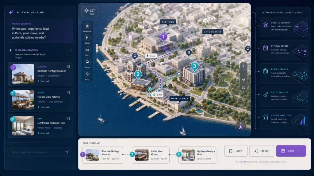
خريطة سياحة الذكاء الاصطناعي هي تجربة وجهة تفاعلية تتيح للزوار استكشاف الأماكن من خلال عناصر التحكم التقليدية في الخرائط وأسئلة اللغة الطبيعية. قد تظهر خريطة الوجهة القياسية مناطق الجذب والفنادق والمطاعم والأحداث والمسارات ومحطات النقل ومراكز الزوار. تضيف خريطة سياحة الذكاء الاصطناعي طبقة تفاعل يمكنها تفسير النية ، والجمع بين العديد من القيود ، ومقارنة المناطق ، وتحديث الخريطة الحية مع تطور المحادثة.
قد يطلب الزوار مطاعم مستقلة بالقرب من منطقة متحفية ، أو بعد ظهر يوم ممطر مع اثنين من مناطق الجذب الداخلية ، أو الشواطئ التي يمكن الوصول إليها بدون سيارة ، أو الأنشطة العائلية بالقرب من فندق ، أو الشركات المحلية على طول الطريق إلى المركز التاريخي ، أو خطة مدتها ثلاث ساعات تتجنب عبور المدينة مرتين. يجب ألا تخترع طبقة الذكاء الاصطناعي قائمة الجرد المقصودة. وتظل منظمات الوجهات السياحية ومقدمو خدمات الإقامة وخدمات بيانات الأماكن وأنظمة الأحداث والشركاء المحليين مصادر الحقيقة لفتح المعلومات وإمكانية الوصول والتوافر والأسعار والإغلاقات والتوجيه الرسمي.
استكشفت شبكة أفضل قرى السياحة التابعة للأمم المتحدة للسياحة حلولًا تعمل بالذكاء الاصطناعي للسياحة الريفية، بما في ذلك تجارب الزوار الشخصية والاستخدامات التشغيلية للوجهات المحلية. لا تزال فرق الوجهة بحاجة إلى حقائق محلية محكومة حتى تظل تلك التجارب جديرة بالثقة. ولذلك ينبغي لخريطة السياحة الفعالة أن تربط الاكتشاف الرقمي بالمعلومات المحلية الخاضعة للحكم بدلا من التعامل مع نموذج لغوي عام كقاعدة بيانات الوجهة.
لماذا تحتاج خرائط السياحة إلى نموذج منتج مختلف؟
اكتشاف السياحة ليس استفسار بحث واحد. قد يعرف الزائر الوجهة ولكن ليس الحي أو الفئة أو وقت السفر أو المصطلحات المحلية أو جدول التشغيل أو الترتيب المناسب للأنشطة ، مع تحقيق التوازن بين الطقس والتنقل والأطفال والميزانية وساعات العمل والنظام الغذائي والنقل والوقت. يجب أن تدعم الخريطة الإلهام والتوجه والاختيار والتسلسل والحركة والقرار والتكيف عندما يتغير السياق. قائمة من عوامل الجذب تتعامل مع جزء فقط من تلك الرحلة. تجمع خريطة سياحة الذكاء الاصطناعي المفيدة بين الخريطة ومحتوى الوجهة ونية المستخدم والإجراء التالي المرئي.
ما الذي ستبنيه؟
وتشمل التجربة المستهدفة موقعًا إلكترونيًا للوجهة أو الضيافة ذات العلامات التجارية، وخريطة تفاعلية حية، وأماكن منسقة ومحتوى محلي، ومساعدًا لخرائط الذكاء الاصطناعي أو سطح بحث محادثة، ونتائج مكان الوعي بالخرائط، وطرقًا أو تسلسلًا جغرافيًا، وتجارب محفوظة أو مشتركة، وتفاعلات زائرين قابلة للقياس، وحدود واضحة للبيانات والحوكمة. يجب أن تشحن هذه القطع كرحلة منتج واحد بدلاً من أن تشحن كأدوات منفصلة. يمكن أن تبدأ الوجهة أصغر ، ولكن يجب أن تترك الهندسة المعمارية مجالًا لكل من هذه القدرات.
التفاعل البسيط يظهر النمط بوضوح. الزائر لديه فترة ما بعد الظهيرة المجانية ، لا سيارة ، ويريد الطعام المحلي بالإضافة إلى محطة ثقافية واحدة. ويعيد مساعد خريطة الذكاء الاصطناعي منطقة مدمجة بها سوق، ومطعمان مملوكان محلياً، ومتحف على مسافة قريبة، ويضع المحطات على الخريطة، ويأمرهما بالحد من التراجع. يجب أن تظهر الواجهة الأماكن المقترحة وعلاقاتها الجغرافية وسبب كل توصية. يبقى الزائر حراً في إزالة أو إعادة ترتيب أو استبدال التوقف.
ما المهام الأساسية لخريطة السياحة؟
عرض الوجهة بوضوح
يحتاج الزوار إلى هيكل جغرافي قبل أن يحتاجوا إلى جرد شامل. استخدم الخريطة لشرح المناطق ومراكز النقل ومراكز الزوار ومناطق الجذب الرئيسية ومناطق الإقامة والواجهات البحرية والحدائق ومناطق الأحداث والمناطق الموسمية والخدمات العملية. خريطة كثيفة تعرض كل سجل في وقت واحد تخلق منافسة بصرية. ابدأ بتسلسل هرمي جغرافي مفيد ، ثم اكشف عن التفاصيل من خلال التكبير والمرشحات والبحث والمحادثة.
فهم نية الزائر
غالبًا ما يعبر المسافرون عن الأهداف بدلاً من الفئات."المساء الرومانية" ، "جيدة لعطلة قصيرة" ، و "شيء محلي بعيدًا عن الشوارع الأكثر ازدحامًا" ليست حقول قاعدة بيانات. يجب أن يترجم المنتج النية إلى قيود صريحة - المنطقة ، والفئة ، ووضع السفر ، والوقت المتاح ، وحالة الفتح ، وإمكانية الوصول ، والميزانية ، وملاءمة الطقس ، ونوع المجموعة ، والأولويات المحددة للوجهة - التي يمكن تقييمها مقابل البيانات الموثوقة. الذكاء الاصطناعي ذو قيمة في التفسير. وينبغي أن يظل الاسترجاع والأهلية والتحقق من الحقائق استخدام خدمات موثوقة وبيانات مملوكة للوجهة.
تقديم توصيات، لا مجرد استرجاع نتائج
يجب أن تشرح توصية السياحة الملاءمة. وبدلاً من إعادة عشرة مطاعم قريبة، قد يصنف النظام في المرتبة الثالثة لأنها تتطابق مع المطبخ، أو تفتح النوافذ، أو قرب الطريق، أو احتياجات إمكانية الوصول التي تم التحقق منها، أو برنامج رسمي للأعمال المحلية، أو خط سير متماسك جغرافياً. تعتمد جودة التوصية على السمات الأساسية. لا يمكن للخريطة أن تصنف بشكل مسؤول لإمكانية الوصول أو الملكية المحلية أو الاستدامة أو الملاءمة العائلية ما لم تدعم بيانات المصدر هذه الادعاءات بالفعل.
تنسيق التنقل ودعم النتيجة المرجوة
الموقع يؤثر على جودة سير السير. يجب أن تساعد أدلة الوجهة الزوار على تجنب التراجع غير الضروري ، ومقارنة أنماط المشي والعبور ، وفهم حدود المنطقة ، وتحديد الأماكن القريبة من الطريق المخطط له. تدعم واجهة برمجة تطبيقات الأماكن من Google البحث النصي والقريب وتفاصيل المكان ومعرفات المكان المستقرة والبحث على طول مسار محسوب مسبقًا ؛ تظل المسارات وخدمات المكان منفصلة عن محتوى الوجهة وسياسة الترتيب. يجب أن تربط الخريطة أيضًا الاكتشاف بخطوة تالية: الاتجاهات ، وصفحات المكان الرسمية ، والتذاكر ، والغرف أو الطاولات ، والمكالمات ، والحفظ ، وتوقف خط السير ، والمشاركات ، والتنزيلات ، أو الاتصال بمركز الزوار. لا تقيس النجاح فقط من خلال وجهات نظر الخريطة.
تمثيل الوجهة بمسؤولية
تؤثر منصة السياحة على الاهتمام وتدفق الإنفاق. يجب أن تقرر فرق الوجهة كيفية تعامل النظام مع المناطق المكتظة ، والإغلاق الموسمي ، والمواقع الطبيعية أو الثقافية الهشة ، والسياحة الريفية والمجتمعية ، والشركات المحلية ، وإمكانية الوصول ، والنقل العام ، وسلامة الزوار ، وأولويات المقيمين. يمكن للخريطة أن تجعل تفاعلات الزوار قابلة للقياس ، ولكن لا ينبغي لها أن تدعي حل إدارة الوجهة من حيدتها.
كيف تنتقل البنية من سؤال إلى إجراء على الخريطة؟
| طبقة | المسؤولية |
|---|---|
| واجهة الزوار | الخريطة والبحث والدردشة بالذكاء الاصطناعي والفلاتر وسير السير واللغة وعناصر التحكم في إمكانية الوصول |
| منصة السياحة المضيفة | جلسة الزائر، العلامة التجارية للوجهة، الموافقة، الأذونات، روابط الحجز، وسير العمل |
| طبقة تفاعل الذكاء الاصطناعي | تفسير النوايا، ومعالجة الأسئلة، والشرح، وإجراءات الخريطة المدعومة |
| محتوى الوجهة | الأوصاف الرسمية والحملات والأحداث والإغلاقات وإمكانية الوصول والإرشادات المحلية |
| المكان وخدمات التوجيه | وضع الهوية والإحداثيات والبحث والطرق ووقت السفر وسمات المزود |
| نظم الأعمال | الحجز، التذاكر، الإقامة، المخزون، إدارة علاقات العملاء، وسجلات الشركاء |
| التحليلات | الوصول والاكتشاف والمشاركة والأنماط الجغرافية والإجراءات المكتملة |
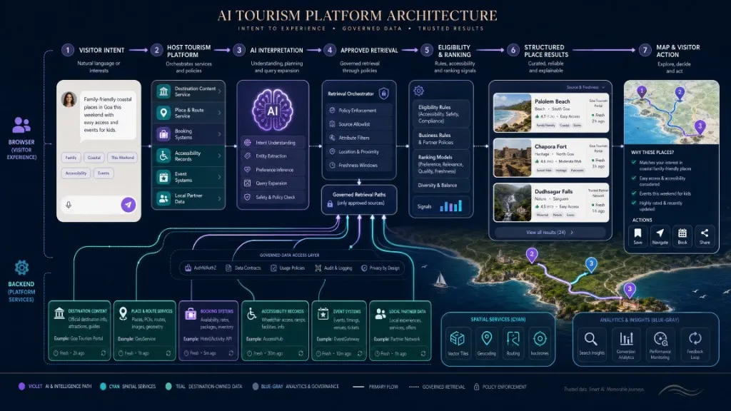
القاعدة المعمارية الأكثر أهمية هي الفصل بين المسؤولية. وتمتلك المنظمة السياحية توجيهات رسمية للوجهة. يمتلك مزود بيانات المكان السمات التي تغطيها خدمته. يمتلك نظام الحجز أو التذاكر التوافر والمعاملات. تفسر طبقة الذكاء الاصطناعي طلب الزائر وتنسق الإجراءات المسموح بها. يقرر تطبيق المضيف ما قد يراه المستخدم ويفعله. التدفق الآمن هو نية الزائر ، ثم تفسير الذكاء الاصطناعي ، ثم الموافقة على الاسترجاع ، ثم الأهلية والترتيب ، ثم نتائج المكان المنظمة ، ثم رسم خريطة الإجراء ، ثم التفسير المرئي. لا تدع التطبيق يستنتج حقائق حاسمة من نص نموذج حر عندما يكون كائن مكان منظم أو سجل وجهة رسمي أو نظام حجز متاحًا.
كيف تبني نموذج محتوى الوجهة أولاً؟
خريطة السياحة للذكاء الاصطناعي موثوقة فقط مثل نموذج المحتوى الخاص بها. يجب أن يكون لكل مكان معرف داخلي مستقر. عند استخدام مزود خارجي، قم بتخزين معرف المزود المسموح به بموجب شروطه وحافظ على علاقة واضحة بالسجل الداخلي للوجهة. قد يتضمن سجل المكان المفاهيمي الهندسة والفئات وعناوين URL الرسمية والحجوزات وسمات إمكانية الوصول مع المصدر والتاريخ المستعرض وحالة النشر. المثال هو المفاهيمي وليس مخطط Kaleidr الحالي.
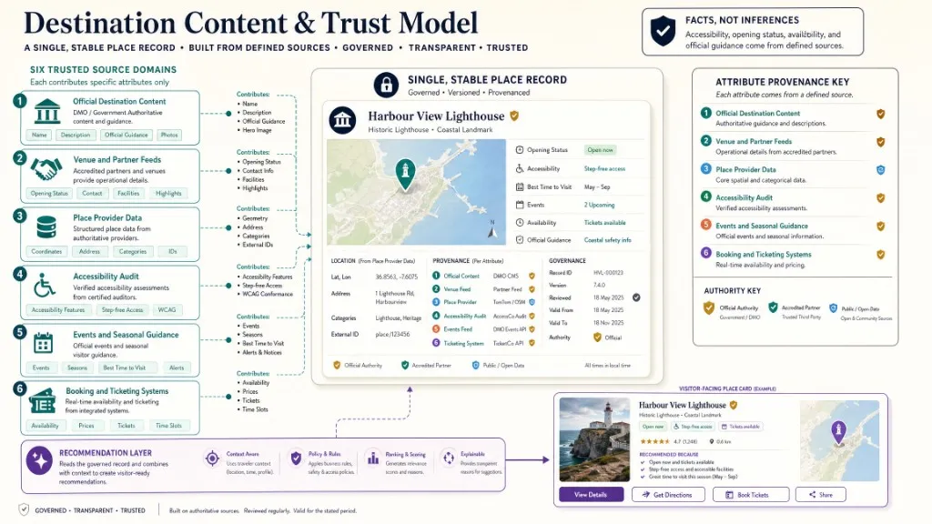
لا تدمج الحقائق دون الحفاظ على المصدر. وتشمل المصادر المحتملة سجلات إدارة الوجهات، وخلاصات المكان أو الشركاء، ونظم التذاكر والإقامة، ومقدمي الخدمات العامة، والبيانات البلدية المفتوحة، ووكالات النقل العابر، وعمليات مراجعة إمكانية الوصول، وتقويمات الأحداث، والتنظيم التحريري. قد تتعارض ساعات العمل من مزود المكان ومعلومات الإغلاق المؤقتة من مكتب الوجهة. يحتاج التطبيق إلى سلطة محددة وسياسة نضارة لكل سمة.
نموذج الوقت صراحة مع فترات الصلاحية، والجداول الزمنية الموسمية، والإغلاق المؤقت، ونوافذ الحدث، والمراجعة والعواطم الزمنية المصدر، والتوقيت، وآخر نتيجة التزامن. المكان الموجود ليس بالضرورة قابلاً للزيارة في الوقت المطلوب. نموذج إمكانية الوصول كبيانات واقعية بدلاً من تسمية غامضة "يمكن الوصول إليها": دخول مجاني ، ومرحاض يمكن الوصول إليه ، والوصول إلى المصعد ، ودعم السمع ، وساعات الهدوء ، والمعلومات اللمسية ، والوصول إلى مواقف السيارات ، وسياسة الخدمة والحيوان ، واعتبارات التضاريس ، كل منها مع مصدر وتاريخ التقييم. لا تدع الذكاء الاصطناعي يستنتج إمكانية الوصول من الصور الفوتوغرافية أو أوصاف المكان العامة.
كيف تستند توصيات الذكاء الاصطناعي إلى أدلة الوجهة؟
توصيات السياحة تخلق عواقب السمعة والتجارية. يجب أن يسترد النظام الموثوق به المرشحين من المصادر المعتمدة ، ويحل كل مرشح إلى مكان مستقر ، ويطبق قواعد الأهلية الصريحة. يجب أن يستخدم التصنيف إشارات موثقة. يجب أن تبقى معلومات المصدر مرفقة. يجب أن يعرض المنتج حالة عدم اليقين ، ويرفض الطلبات غير المدعومة ، ويظهر حالات لا تنتج بوضوح.
يمكن لطبقة الذكاء الاصطناعي تحويل "بعد الظهر المريح مع الطعام المحلي بالقرب من المحطة" إلى قيود منظمة مثل السرعة والمدة والموضوعات والمرساة ووضع السفر والحد الأقصى للدقائق بين التوقف. المثال هو المفاهيمي بدلا من مخطط شحنها. يجب أن يسترجع التطبيق ويتحقق من صحة الأماكن من خلال أنظمة الوجهة والمزود. تشمل أسباب التوصية المفيدة الموقع داخل المنطقة المطلوبة ، والمفتوحة خلال الفترة المحددة ، ضمن قيود وقت المشي ، وإدراج البرنامج الرسمي ، وتوافق إمكانية الوصول الذي تم التحقق منه ، والقرب من المسار الحالي ، والملاءمة من نوع المجموعة. تجنب التفسيرات غير المدعومة مثل "الأصيلة" أو "الآمنة" أو "الجوهرة الخفية" أو "المستدامة" ما لم تحدد الوجهة معايير وبيانات لتلك العلامات.
كيف تصمم تجربة الاكتشاف؟
تجعل صناديق الدردشة الفارغة المستخدمين يخمنون ما يمكن للنظام القيام به. قدم أمثلة خاصة بالوجهة تعكس القدرات الحقيقية المدعومة بدلاً من ذلك. وتشمل المطالبات المفيدة ثلاث ساعات بالقرب من المدينة القديمة، وأنشطة داخلية لصباح ممطر، ومحلات تجارية مستقلة بالقرب من المشي النهر، ومسار عائلي بدون سيارة، ومناطق جذب يمكن الوصول إليها بالقرب من فندق، أو أماكن على طول الطريق إلى المطار. يجب أن يرسم كل مثال البيانات والإجراءات التي يمكن للمنتج تقديمها بالفعل.
حافظ على مزامنة الخريطة والإجابة. عندما يذكر المساعد مكانًا ما ، يجب أن يكون المكان مرئيًا وقابلًا للاختيار على الخريطة. عندما يختار الزائر علامة، يجب أن تكون التفاصيل المقابلة متاحة في النص. يجب على الزوار فهم الأماكن التي تنتمي إلى الإجابة ، ولماذا تحركت الكاميرا ، وما هي المنطقة الجغرافية التي تم البحث عنها ، وكيف يتم طلب الأماكن ، والمصدر الذي يدعم النتيجة. الحفاظ على عناصر التحكم التقليدية - المفلسات ، وعرض القائمة ، والمقلاة والتكبير ، وإعادة الضبط ، والموقع الحالي ، وتصفح الفئة ، وتحرير مسير السير ، واختيار المكان المباشر - بحيث يمكن للزوار التعافي عندما يسيء المساعد فهم الطلب.
تحدث العديد من التفاعلات السياحية على الهاتف المحمول تحت ضغط الوقت. اجعل الأسئلة قصيرة. عرض ملاحظات الخريطة الفورية. قم بتخزين مسيرة الرحل الحالية محليًا أو في حساب الزائر. الحفاظ على التقدم أثناء انقطاع الشبكة. تجنب إنشاء الحساب الإلزامي قبل الاستكشاف الأساسي، وجعل التوجيهات وإجراءات الحجز بارزة.
كيف تعمل برامج الرحلات والبحث المراعي للمسار؟
مسيرة هو أكثر من قائمة محفوظة. يعتبر خط السير المفيد أوقات العمل ، ووضع السفر ، والمدة الإجمالية ، والوقت في كل محطة ، وطلب المسار ، والإغلاق المؤقت ، ونوافذ الحجز ، وسهولة الوصول ، ونقاط البداية والنهاية للزائر. يمكن أن يكون البحث عن المكان مدركًا للطريق. تصف وثائق واجهة برمجة تطبيقات الأماكن من Google البحث عن الأماكن القريبة من الطريق وإرجاع النتائج المتحيزة إلى بوليلين محسوب مسبقًا من واجهة برمجة تطبيقات الطرق. يمكن للمنتج السياحي استخدام قدرات مماثلة للمزود أثناء تطبيق محتوى الوجهة وسياسة الترتيب الخاصة به. لا تعد خط سير محسن ما لم يحسب التنفيذ المسار بالفعل ويثبت صحةه. القائمة التي يتم إنتاجها بترتيب معقول ليست هي نفسها خطة موجهة.
كيف تنشئ خريطة وجهة متوافقة مع العلامة التجارية؟
ينبغي أن تدعم خريطة الأساس قصة الوجهة من دون أن تنافس محتواها. استخدم تدرج الألوان والطباعة وكثافة التسميات ومعالجة المعالم وحدود المناطق وتنسيق التضاريس والمياه وإبراز المسارات والأيقونات الخاصة بالوجهة وسمات النهار والليل. ينظم Kaleidr Studio العمل وفق مسار Prompt → Process → Refine → Deploy، ويدعم تصميم الخرائط المخصصة والنشر التفاعلي والبلاطات المخصصة والتصور ثلاثي الأبعاد وطبقات البيانات الحية ومجموعات البيانات والتراكبات وإعدادات الأنماط القابلة لإعادة الاستخدام والألوان والطباعة والتسميات. تستطيع مؤسسة سياحية إنشاء لوحة متوافقة مع علامتها التجارية ثم إضافة الأماكن المنسقة وتجربة الزوار فوقها. راجع كيفية إنشاء خريطة أساس مخصصة متوافقة مع العلامة التجارية لمسار التصميم والتنفيذ، وقارن أيضاً نهج إنشاء موقع خرائط من دون برمجة عند بناء موقع وجهة كامل.
كيف ينبغي أن يعمل التصميم متعدد اللغات والمتاح للجميع؟
يجب ألا تكون الخريطة التفاعلية هي الطريقة الوحيدة للوصول إلى معلومات الوجهة. يوفر WCAG 2.2 توصيات إمكانية الوصول الحالية إلى W3C لمحتوى الويب. وينبغي أن يوفر تنفيذ خريطة السياحة نصاً مكافئاً، وترتيب تركيز ذا مغزى، وضوابطاً يمكن الوصول إليها بلوحة المفاتيح، وتبايناً كافياً، ورسائل مفهومة عن الحالة، وبدائل للمعلومات المنقولة بصرياً. وتشمل المتطلبات العملية عرض قائمة متزامنة، وروابط مكان وصفية، والوصول إلى لوحة المفاتيح للبحث والنتائج، وحالات التركيز المرئية، وإعلانات الحالة لإجابات التحميل والبث، وبدائل نصية للطرق، ومؤشرات الحالة غير الملونة، وأهداف اللمس المناسبة للجوال، والدعم المخفض الحركة. إمكانية الوصول هي أيضًا مشكلة في المحتوى: جمع حقائق محددة ومراجعة في المكان بدلاً من استخدام واجهة الخريطة كبديل.
غالبًا ما تعبر خرائط السياحة الحدود اللغوية والثقافية. خطة لسلاسل الواجهة المترجمة ، وأسماء الأماكن المترجمة والبديلة ، والتخطيطات من اليمين إلى اليسار ، واتفاقيات العناوين المحلية ، والوحدات وتنسيقات الوقت ، والحفاظ على لغة المصدر. ولا تزال توجيهات الوجهة الهامة بحاجة إلى استعراض بشري. يمكن أن تساعد الترجمة الآلية في توسيع نطاق العمل التحريري ، ولكن يجب أن تتلقى عمليات الإغلاق والسلامة وإمكانية الوصول وتذاكر السفر واللوائح وتعليمات الطوارئ مراجعة معتمدة من الوجهة.
كيف تقيس نتائج الوجهة والزوار؟
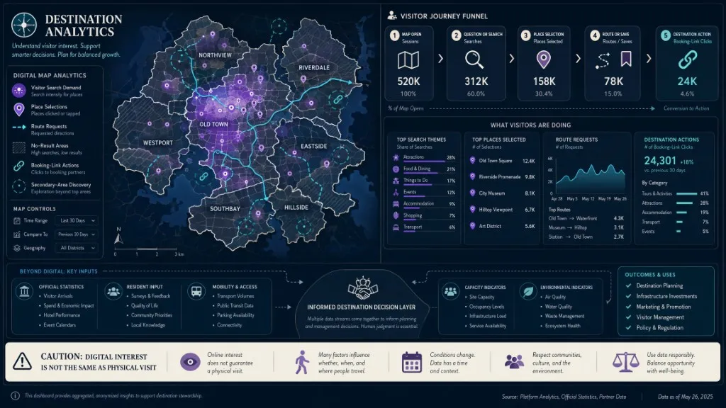
يقيس Kaleidr Analytics مشاركة الارتباط المتتبع على نطاق المشروع وحركة مرور الطرف الأول: يفتح ، والنقرات ، والمشاهدات ، والتحويلات ، والزوار ، ومشاهدات الصفحات ، والتصنيفات الإقليمية ، والتجمع المكاني H3. تسرد الأسعار الوصول إلى التحليلات عبر خطط Free و Pro و Enterprise. قم بتأكيد بطاقات مساحة العمل الدقيقة لمؤسستك قبل التعامل مع الملصقات التسويقية كمجالات حرفية. يمكن لفرق الوجهة تعيين رحلات المنتج على تلك الإشارات - الخريطة أو الارتباط المفتوح أو البحث أو السؤال أو تحديد المكان أو المسار أو الحفظ أو ربط الحجز أو عمل الوجهة - دون اختراع أعداد عمومية وتكبيرة كمؤشر KPI للنجم الشمالي.
تتضمن مسارات المنتج المفيدة الاكتشاف (فتحت الخريطة → البحث أو السؤال → عودة النتيجة → المكان المختار ← الإجراء التالي) ، خط سير السير (المكان المحدد → تم حفظه → خط سير التنفيذ الذي تم إنشاؤه ← المسار المطلوب ← المشاركة) ، والتجارية (تفاصيل المكان مفتوحة → الحجز أو رابط الشريك مفتوح → التحويل المؤكد حيث يُسمح بالإسناد). تشمل قيمة الوجهة أيضًا توزيع المناطق ، والمشاركة في المناطق الثانوية ، والجغرافيا بدون نتيجة ، والطلب على المحتوى الموسمي ، ومصلحة النقل ، والإحالات التجارية المحلية ، والبحث المتعلق بإمكانية الوصول ، والطلب على اللغة ، وتسليم مراكز الزوار. لا تستنتج الزيارة المادية من نقرة الخريطة ما لم يقم نظام قياس معتمد آخر بالتحقق من صحة الزيارة.
كيف تدعم الإشارات المكانية الإدارة المسؤولة للوجهة؟
يمكن أن تساعد خريطة السياحة الوجهة على فهم الاهتمام وتوزيع الاكتشاف ، ولكن يجب أن يتجنب التنفيذ المطالبات المتلاعبة أو غير المدعومة. وتشمل الاستخدامات الممكنة التوصية بالمناطق غير المكتشفة بشكل غير مكتشف عندما تناسب الطلب بشكل حقيقي، وإظهار خيارات النقل العام والمشي، وإغلاق الإغلاقات الرسمية، وتقديم التوجيه الموسمي، وتعزيز التجارب المجتمعية والريفية من خلال برامج محددة، وتحديد طلب البحث الذي لا يلبيه المحتوى الحالي، وقياس المناطق التي تحظى بالاهتمام. يمكن أن تساهم بيانات تفاعل الخرائط بإشارة واحدة. تفسيرها جنبا إلى جنب مع الإحصاءات الرسمية، والمدخلات المقيمة، والبيانات البيئية، وبيانات التنقل، وسياسة الوجهة. الاهتمام الرقمي ليس هو نفسه الزيارة المادية.
كيف تبني التجربة باستخدام Kaleidr؟
ابدأ بقالب الضيافة
تربط صفحة Kaleidr للذكاء الاصطناعي بقالب للضيافة يعرض وجهات ورحلات منسقة فوق خريطة أساس مصممة، مع ملخصات للأماكن تُفتح بالنقر والسؤال، وذلك في أداة تخصيص قالب Kaleidr للضيافة. يمكن لفرق الوجهات والضيافة تقييم نموذج التفاعل قبل الالتزام بتطبيق مخصص. يمثّل القالب نقطة البداية الأسرع عندما يكون الهدف إثبات قيمة التجربة للزوار بسرعة.
أنشئ وانشر في Kaleidr Studio
يدعم Kaleidr Studio مفاهيم الخرائط الأولى السريعة والهيكل المكاني الذي يتم توليده بالذكاء الاصطناعي وصقل التصميم والنشر عبر المنصات الرقمية. يمكن للفرق استخدام Studio لخرائط الوجهات المنسقة والأدلة المواضيعية والحملات والطرق والمناطق والأنظمة المرئية ذات العلامات التجارية. يدعم نفس سير العمل التنقيح لاحقًا مع نضوج قواعد المحتوى والترتيب.
ضمّن عارضاً منشوراً
يحمّل نمط البدء السريع الحالي في Kaleidr للخريطة المنشورة حزمة SDK المضمنة من شبكة Kaleidr لتوصيل المحتوى، ثم يركّب عنصر العارض باستخدام معرّف المشاركة. استخدم معرّف المشاركة وإعدادات النطاق من الخريطة المنشورة، وتحقق من أحدث متطلبات العارض في وثائق مطوري Kaleidr.
<!-- Load https://cdn.kaleidr.com/embed/v1/kaleidr.js before this element -->
<kaleidr-map
  product="viewer"
  share-id="DESTINATION_SHARE_ID"
  style="height: 640px">
</kaleidr-map>
أضف محادثة الذكاء الاصطناعي إلى خريطة قائمة
يمكن لمنصة سياحية تستخدم Mapbox أو Google Maps أو MapLibre أن تضيف مساعد خرائط Kaleidr بالذكاء الاصطناعي من دون استبدال محرّك العرض. يتبع المثال نموذج المنتج العام الحالي في Kaleidr. ينبغي لتطبيقات الإنتاج التحقق من متطلبات هدف الخريطة والنطاقات المسموح بها وإصدار المزوّد المدعوم ونطاق المفتاح. راجع كيفية إضافة محادثة بالذكاء الاصطناعي إلى Mapbox أو Google Maps أو MapLibre لمسار المطور، و إضافة مساعد محادثة بالذكاء الاصطناعي إلى خريطة تفاعلية للإطار المتعلق بالمنتج.
<!-- Load https://cdn.kaleidr.com/embed/v1/kaleidr.js before these elements -->
<div id="map" aria-label="Destination map"></div>
<kaleidr-map
  product="chat"
  map-target="#map"
  publishable-key="YOUR_PUBLISHABLE_KEY">
</kaleidr-map>
استخدم واجهات Enterprise API لبنية منتج مخصصة
يتم وضع Kaleidr Enterprise حول واجهات برمجة التطبيقات للاستدلال وأنظمة التصنيف والتحليلات ودعم النشر وواجهات برمجة التطبيقات القابلة للتطوير للمنتجات المدركة للموقع. يجب أن تحدد منصة الوجهة التي تحتوي على محتوى مملوك أو أنظمة شركاء أو ترتيب مخصص أو استخدام أعلى شروط الاسترجاع والتفويض والنشر والخدمة مع فريق المؤسسة. تصف صفحات المنتج العام سطح القدرة ؛ تفاصيل العقد تنتمي إلى محادثة Enterprise هذه.
كيف تبدو خطة تنفيذ مدتها 90 يوماً؟
الأيام 1-30 تحدد والنموذج الأولي. اختر شريحة زائر واحدة ومنطقة وجهة واحدة. الوثيقة تدعم الأسئلة. محتوى المخزون وملكية المصدر ، ثم تحديد الثغرات في الساعات وإمكانية الوصول والفئات والإحداثيات. قم بإنشاء نموذج أولي للخريطة ذات علامة تجارية مع 30-100 مكان منسق بدلاً من استيراد كل سجل. اختبر قالب الضيافة أو خريطة تم نشرها من قبل Studio ، وحدد إجراء الزائر الأساسي قبل توسيع النطاق.
أيام 31-60 دمج والتحقق من صحة. ربط المكان المعتمد وخدمات التوجيه. إرفاق مساعد خريطة AI أو بناء واجهة المحادثة. أضف قواعد المصدر والنضارة ، ثم قم بتنفيذ حالات عدم النتيجة والغموض والإغلاق والخطأ. إضافة عرض القائمة وعناصر التحكم في إمكانية الوصول. اختبار على شبكات المحمول ولغات متعددة. إضافة أجهزة تحليلية، ومراجعة التوصيات مع خبراء الوجهة والشركاء المحليين.
أيام 61-90 إطلاق والتعلم. إطلاق جمهور أو حملة محدودة. مراقبة جودة النتيجة والاستعلامات بدون نتيجة. قم بقياس اختيار المكان والطرق والحفظ والمشاركة وإجراءات الشركاء. تحديد الثغرات الجغرافية والمحتوى، واستعراض ما إذا كانت التوصيات تركز الاهتمام بشكل كبير. تحديث الأمثلة الفورية وقواعد التصنيف. توسيع المخزون فقط بعد أن يؤدي سير العمل الأولي بشكل موثوق.
ما الأخطاء التي ينبغي للفرق تجنبها؟
| خطأ | ماذا يحدث | التصحيح الموصى به |
|---|---|---|
| التعامل مع الخريطة كاستراتيجية وجهة كاملة | الأماكن تظهر بدون قيمة الزائر | تحديد رحلة الزائر والإجراء التالي القابل للقياس |
| السماح للنموذج باختراق المخزون | أماكن ملفقة أو قديمة تضر الثقة | استرجاع المرشحين من المصادر المعتمدة |
| نشر كل سجل في وقت واحد | الحمل الزائد البصري والمعرفي | استخدام التسلسل الهرمي والمناطق والمواضيع والتفاصيل التقدمية |
| الترتيب فقط حسب المسافة | الأماكن القريبة قد لا تناسب الوقت أو الوصول | استخدام قيود صريحة وإشارات التصنيف المعتمدة |
| استخدام تسميات "يتم الوصول إليها" الغامضة | التوجيهات المضللة | قم بتخزين سمات محددة مع تاريخ المصدر والمراجعة |
| إخفاء ملكية المصدر | لا يمكن للموظفين حل النزاعات | الحفاظ على المصدر وتحديد السلطة حسب السمة |
| جعل الدردشة الواجهة الوحيدة | يفقد المستخدمون مسارات الاسترداد | حافظ على البحث والمرشحات وعرض القائمة وعناصر التحكم في الخرائط |
| خريطة القياس تفتح فقط | حركة المرور خاطئة للمشاركة | تتبع الاختيار والمسار والحفظ والمشاركة وإجراءات الحجز |
| على افتراض النقر يثبت زيارة | تأثير الوجهة مبالغ فيه | التحقق من صحة الزيارات بشكل منفصل؛ وصف المشاركة الرقمية بدقة |
| تجاهل أولويات المقيمين والمقصد | الضغط يكثف في المناطق المزدحمة | الجمع بين بيانات الزوار مع السياسة والقدرة والمدخلات المحلية |
ما المؤسسات السياحية الأكثر استفادة؟
يمكن لمنظمات تسويق وإدارة الوجهات تنظيم المحتوى الرسمي والإجابة على أسئلة الزوار وتوزيع الاكتشاف ودعم الحملات وقياس الطلب الرقمي. يمكن للفنادق والمنتجعات ومجموعات الضيافة توفير خدمة كونسيرج محلية ذات علامة تجارية مع الأماكن القريبة والمعلومات العملية والطرق والتوصيات المعتمدة من الممتلكات. يمكن للمناطق الجذبية والمناطق الثقافية ربط الأماكن والفعاليات والجداول الزمنية والطرق وقصص المناطق. ويمكن لشبكات السياحة الريفية والمجتمعية أن تعرض تجارب مشتتة بشكل متماسك وأن تجعل متطلبات السفر مرئية. يمكن للأسواق السياحية إضافة اكتشاف الوجهة التخاطبية داخل المنتج. يمكن لمنظمات المؤتمرات والفعاليات مساعدة المندوبين على فهم الأماكن ومناطق الإقامة والنقل والمطاعم والأنشطة حول جدول الأحداث.
هل تبني الحل أم تشتريه أم تستخدم نموذجاً هجيناً؟
بناء داخليا عندما يكون اكتشاف الوجهة هو القدرة الملكية الأساسية، والمؤسسة لديها قوية الجيومكانية، والبيانات، والذكاء الاصطناعي، وفرق المنتج، وترتيب يعتمد على أنظمة داخلية فريدة من نوعها، ويمكن للمنظمة الحفاظ على جودة البيانات والبنية التحتية مع مرور الوقت. شراء منصة عندما تكون السرعة في السوق مهمة ، يحتاج الفريق إلى خريطة أو ذكاء اصطناعي أو محرر أو مشاهد أو بلاط أو طبقة تحليلات ، أو تجربة الخريطة مهمة ولكن ليس التركيز الهندسي الأساسي ، أو يحتاج الفريق إلى نموذج تضمين أو واجهة برمجة تطبيقات مدعوم. استخدم نموذجًا هجينًا عندما يظل محتوى الوجهة الرسمي في الأنظمة الداخلية، ويوفر مقدمو الخدمات الخارجيون بيانات المكان أو المسار، وتوفر منصة الاستخبارات المكانية المحادثة أو الترتيب أو إجراءات الخرائط أو العرض التقديمي، وتتحكم المنصة المضيفة في الحجز والهوية والأذونات والإجراءات النهائية. غالبًا ما يكون النموذج الهجين مناسبًا لأن محتوى الوجهة وبيانات المكان العام والطرق وتفاعل الذكاء الاصطناعي والمعاملات التجارية لها مالكون مختلفون ودورات تحديث.
قائمة التحقق النهائية قبل الإطلاق
- تعريف شريحة الزوار الأولية
- الأسئلة المدعومة الموثقة
- تحديد مصدر محتوى الوجهة الرسمية
- معرفات الأماكن المستقرة المخصصة
- الإحداثيات والحدود المصادق عليها
- فتح والمنطق الموسمي المنفذ
- سمات إمكانية الوصول مصدرها واستعراضها
- شروط المزود و الإسناد تمت مراجعته
- استجابات الذكاء الاصطناعي على أساس الاسترجاع المعتمد
- أسباب التوصية مرئية
- الدول التي لا توجد نتيجة وغموض تنفذها
- الخريطة والقائمة تبقى متزامنة
- الضوابط اليدوية المحفوظة
- اختبار تجربة الهاتف المحمول والنطاق الترددي المنخفض
- تم اختبار سير عمل لوحة المفاتيح وقارض الشاشة
- استعراض توطين اللغات وأسماء الأماكن
- المطالبات المتعلقة بالطريق ومسار الرحلات المثبتة
- تنفيذ أجهزة التحليلات
- مراجعة متطلبات الموافقة والخصوصية
- الشركاء المحليون وموظفي الوجهة المعنيين
- مقاييس الإطلاق المرتبطة بنتائج الزوار والوجهة
الخلاصة النهائية
يجب ألا تكون خريطة سياحة الذكاء الاصطناعي مساعدًا لخرائط الذكاء الاصطناعي موضوعة بجانب خريطة عامة. يحتاج المنتج إلى نموذج محتوى الوجهة ، وهوية مكان مستقرة ، ومصادر موثوقة ، وقواعد توصية صريحة ، وخريطة وقائمة متزامنة ، وإجراءات عملية للزوار ، وبدائل يمكن الوصول إليها ، ونتائج قابلة للقياس. يضيف الذكاء الاصطناعي قيمة عندما يعبر المسافرون عن نية معقدة لا يمكن لمرشح ثابت التقاطها. تضيف الخريطة قيمة من خلال جعل المسافة والمنطقة والطريق والتسلسل مرئية. تضيف المنظمة ذات الوجهة قيمة من خلال تنظيم المحتوى الرسمي والأولويات المحلية وإمكانية الوصول ورحلة الخدمة التجارية أو العامة.
يمكن لـ Kaleidr دعم تلك التجربة من خلال قالب الضيافة ، والذكاء الاصطناعي المكاني ، والاستوديو ، والمشاهدين المنشورين ، ومساعد خريطة الذكاء الاصطناعي المرفق بخريطة موجودة ، والبلاط المصمم ، والتحليلات ، وواجهات برمجة التطبيقات المؤسسية. يعتمد المسار المناسب على ما إذا كانت المنظمة بحاجة إلى خريطة حملة أو دليل وجهة ذات علامة تجارية أو تجربة كونسيرجي أو منصة سياحية متكاملة للغاية. ابدأ بأضيق رحلة زائر تثبت قيمة الوجهة، ثم توسيع المخزون والأتمتة فقط بعد أن يصمد سير العمل الأول.
أطلق تجربة وجهة مدعومة بالذكاء الاصطناعي
أنشئ خريطة سياحية منسقة، وأضف أسئلة تراعي سياق الخريطة، وطبّق هوية الوجهة، ثم انشر التجربة من خلال قالب أو Kaleidr Studio. استخدم Kaleidr Spatial AI لتقييم نموذج الوجهة الحواري بسرعة. وعندما يحتاج منتج الوجهة أو الضيافة إلى بنية مخصصة، راجع خيارات العارض ومساعد الخرائط بالذكاء الاصطناعي والمحرر والبلاطات والمصادقة وEnterprise API في وثائق المطورين.
الأسئلة الشائعة
ما خريطة السياحة المدعومة بالذكاء الاصطناعي؟
تجمع خريطة السياحة بالذكاء الاصطناعي بين خريطة الوجهة التفاعلية مع اكتشاف اللغة الطبيعية ونتائج المكان المنظمة والتوصيات والطرق وإجراءات الزوار. يفسر الذكاء الاصطناعي النية، في حين أن أنظمة الوجهة والمكان المعتمدة تصادق على المعلومات الواقعية.
كيف تختلف عن خريطة الوجهة التقليدية؟
تعرض خريطة الوجهة القياسية بشكل أساسي الأماكن والفئات المنسقة. يمكن لخريطة سياحة الذكاء الاصطناعي تفسير الطلبات متعددة المتغيرات ، وشرح سبب ملاءمة الأماكن ، وتحديث الخريطة الحية ، ودعم أسئلة المتابعة أو تغييرات خط السير.
هل تستطيع إنشاء برامج رحلات؟
نعم ، عندما يكون للتنفيذ بيانات مكان موثوق بها ، ومعلومات مفتوحة ، وافتراضات المدة ، والتوجيه ، ومنطق مسار الرحلة الصريح. لا ينبغي وصف القائمة التي تم إنشاؤها على أنها مسار محسن ما لم يتم حساب قيود التسلسل والسفر بالفعل.
هل يستخدم الذكاء الاصطناعي بيانات الأماكن العامة أم محتوى الوجهة؟
معظم المنتجات السياحية تحتاج إلى كليهما. يمكن لخدمات الأماكن العامة دعم الهوية والإحداثيات والبحث والسمات المحددة. يجب أن يحكم المحتوى المملوك للوجهة الأوصاف الرسمية والحملات والأولويات المحلية والتوجيه المؤقت ومعلومات الشركاء.
كيف تدعم خريطة السياحة الأنشطة التجارية المحلية؟
يمكن للخريطة أن تجعل الشركات المحلية قابلة للاكتشاف من خلال الفئات المنسقة وبرامج الوجهة والتوصيات السياقية والطرق والروابط الرسمية. وينبغي أن تكون معايير الاختيار والترتيب شفافة وأن تستند إلى البيانات المحتفظ بها.
هل يمكن أن تساعد على الحد من فرط السياحة؟
يمكن للخريطة توزيع الانتباه الرقمي ، وإظهار البدائل المناسبة ، وتقديم عمليات الإغلاق ، وقياس الطلب حسب المنطقة. لا يمكن أن يحل السياحة المفرطة وحدها. ولا تزال سياسة المقصد، وبيانات القدرات، ومدخلات المقيمين، والنقل، والإدارة البيئية ضرورية.
ما التحليلات التي ينبغي تتبعها؟
تتبع الأسئلة، عمليات البحث، النتائج المرتجعة، الأماكن المحددة، عمليات الحفظ، مسارات، طلبات المسارات، الحجز أو رابط الشركاء يفتح، الأسهم، الاستفسارات بدون نتيجة، والطلب الجغرافي. لا تظهر مشاهدات الخرائط وحدها قيمة الزائر. يمكن لـ Kaleidr Analytics قياس الفتحات والنقرات والتحويلات وجمع حركة المرور والأنماط الإقليمية للوجهات المتتبعة.
كيف ينبغي معالجة إمكانية الوصول؟
توفير قائمة متزامنة ، والوصول إلى لوحة المفاتيح ، والحالة والضوابط المتوافقة مع الشاشة والقارض ، والتباين الكافي ، وبدائل النص ، وسمات الوصول إلى المكان المستعرضة المحددة. لا تعتمد على الخريطة أو الذكاء الاصطناعي لاستدلال إمكانية الوصول.
هل تعمل Kaleidr مع موقع وجهة قائم؟
نعم. يمكن تضمين المشاهد المنشور بواسطة معرف المشاركة ، ويمكن لدردشة Kaleidr AI أن ترفق بصندوق خرائط مدعوم أو خرائط Google أو خريطة MapLibre من خلال SDK. تحقق من متطلبات الخطة والمفتاح والأصل ومزود الخدمة في الوثائق الحالية.
هل تحتاج الوجهة إلى مطورين لاستخدام Kaleidr؟
ليس بالضرورة. يوفر Kaleidr الذكاء الاصطناعي المكاني والاستوديو وقالب الضيافة لسير العمل بدون رمز أو رمز أقل. تتطلب المنصة المخصصة أو تكامل البيانات الخاصة أو مرفق الخريطة الحالية عادة مشاركة المطور.
المراجع
- Google. Overview. Places API. Google Maps Platform documentation. Accessed 26 July 2026. https://developers.google.com/maps/documentation/places/web-service/overview
- Google. Place IDs. Places API. Google Maps Platform documentation. Accessed 26 July 2026. https://developers.google.com/maps/documentation/places/web-service/place-id
- Google. Search along route. Places API. Google Maps Platform documentation. Accessed 26 July 2026. https://developers.google.com/maps/documentation/places/web-service/search-along-route
- Kaleidr. AI Maps You Can Talk To — Spatial AI. kaleidr.com. Accessed 26 July 2026. https://kaleidr.com/ai
- Kaleidr. Create Custom Maps with AI Map Maker. kaleidr.com. Accessed 26 July 2026. https://kaleidr.com/studio
- Kaleidr. Kaleidr Template Customizer — Hospitality. template.kaleidr.com. Accessed 26 July 2026. https://template.kaleidr.com/customize/?template=hospitality
- Kaleidr. Introduction. Kaleidr Developer Docs. Accessed 26 July 2026. https://docs.kaleidr.com
- Kaleidr. Location Intelligence API & Spatial Infrastructure. kaleidr.com. Accessed 26 July 2026. https://kaleidr.com/enterprise
- Kaleidr. Pricing & Plans. kaleidr.com. Accessed 26 July 2026. https://kaleidr.com/pricing
- Kaleidr. Spatial & Audience Analytics Dashboard. kaleidr.com. Accessed 26 July 2026. https://kaleidr.com/analytics
- UN Tourism. Unlocking the Potential of AI for Rural Tourism: Insights from the BTV Network Tech Talk. Best Tourism Villages. Accessed 26 July 2026. https://tourism-villages.unwto.org/en/news/unlocking-the-potential-of-ai-for-rural-tourism-insights-from-the-btv-network-tech-talk/
- W3C. Web Content Accessibility Guidelines (WCAG) 2.2. Accessed 26 July 2026. https://www.w3.org/TR/WCAG22/
@misc{kaleidr_ai,
  title  = {AI Maps You Can Talk To -- Spatial AI},
  author = {{Kaleidr}},
  note   = {Accessed 26 July 2026},
  url    = {https://kaleidr.com/ai}
}

@misc{kaleidr_studio,
  title  = {Create Custom Maps with AI Map Maker},
  author = {{Kaleidr}},
  note   = {Accessed 26 July 2026},
  url    = {https://kaleidr.com/studio}
}

@misc{kaleidr_hospitality_template,
  title  = {Kaleidr Template Customizer -- Hospitality},
  author = {{Kaleidr}},
  note   = {Accessed 26 July 2026},
  url    = {https://template.kaleidr.com/customize/?template=hospitality}
}

@misc{google_places_overview,
  title  = {Overview},
  author = {{Google}},
  note   = {Places API; accessed 26 July 2026},
  url    = {https://developers.google.com/maps/documentation/places/web-service/overview}
}

@misc{google_search_along_route,
  title  = {Search along route},
  author = {{Google}},
  note   = {Places API; accessed 26 July 2026},
  url    = {https://developers.google.com/maps/documentation/places/web-service/search-along-route}
}

@misc{un_tourism_btv_ai,
  title  = {Unlocking the Potential of AI for Rural Tourism: Insights from the BTV Network Tech Talk},
  author = {{UN Tourism}},
  note   = {Best Tourism Villages; accessed 26 July 2026},
  url    = {https://tourism-villages.unwto.org/en/news/unlocking-the-potential-of-ai-for-rural-tourism-insights-from-the-btv-network-tech-talk/}
}

@misc{wcag22,
  title  = {Web Content Accessibility Guidelines (WCAG) 2.2},
  author = {{World Wide Web Consortium}},
  note   = {Accessed 26 July 2026},
  url    = {https://www.w3.org/TR/WCAG22/}
}