AI Interactive Map Builder: Prompt to Publish

By The Kaleidr Team · Published July 27, 2026 · 19 min read

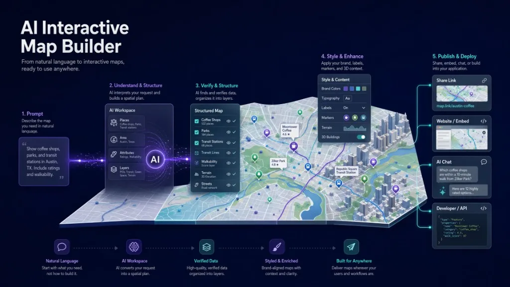
AI Interactive Map Builder: Create and Publish a Map from a Prompt, showing a prompt card, Kaleidr emblem, Austin map, and publish controls.

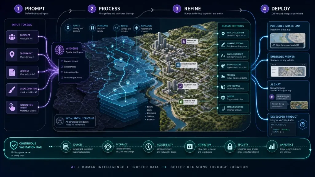
An AI interactive map builder turns a written concept into a functional map that people can explore, refine, share, and embed. Unlike an AI image generator, the builder produces geographic structure—places, layers, labels, styles, camera settings, and interactions—rather than a decorative picture. Kaleidr Studio follows Prompt → Process → Refine → Deploy so teams retain ownership of content, accuracy, design, and publishing while AI accelerates the first draft.

The sections below cover product definition, prompt design, validation, branding, layers, interaction, publish and embed paths, comparisons, use cases, pricing, accessibility, metrics, and a launch checklist. Follow them in sequence for a full Studio build, or skip ahead to Viewer and Editor paths when a map already exists.

Kaleidr product highlights

  • Prompt-first creation: Begin with the map's purpose, audience, geography, content, and desired interaction.
  • Interactive output: Build a working map experience rather than a static generated image.
  • Map-level branding: Refine colors, typography, labels, icons, terrain, 3D buildings, layers, and designed basemaps.
  • Multiple deployment paths: Share a published map, embed a viewer, attach AI chat, mount an editor, or use designed tiles.
  • One product path from idea to production: Start in Studio, then connect Viewer, Chat, Editor, Tiles, Analytics, or Enterprise as the project grows.

A written map prompt transforming into an interactive map with layers, brand styling, publishing, embedding, and AI chat.

What Is an AI Interactive Map Builder at a Glance?

Stage What the user does What the AI can accelerate What still requires human review
Prompt Describes the map, audience, geography, content, and goal Generates an initial spatial structure Scope, factual requirements, intended audience
Process Reviews the generated places, layers, and organization Groups and organizes the initial concept Location accuracy, duplicates, missing content, source quality
Refine Edits design, content, style, labels, and interaction Supports prompt-assisted iteration Brand hierarchy, accessibility, mobile layout, editorial quality
Deploy Publishes, shares, or embeds the map Packages the experience for supported surfaces Permissions, allowed domains, analytics, maintenance, governance

One map evolving through prompt, AI processing, human refinement, validation, and deployment.

Kaleidr Studio documents Prompt → Process → Refine → Deploy as its creation model and positions the product around custom interactive maps, custom tiles, 3D visualization, live layers, reusable overlays, datasets, and brand styling. See Kaleidr Studio. A serious AI interactive map builder should deliver more than visual polish. Useful output includes searchable or clickable places, layers and categories, map navigation, labels and icons, a defined initial camera, filters or information panels, share or publish controls, an embed or developer path, optional AI interaction, and analytics tied to meaningful map actions.

Search language makes the category easy to confuse. “AI map generator” often surfaces fantasy maps, game art, or static illustrations. An AI interactive map builder sits in a different product class: it produces a geographic experience people can query, navigate, filter, update, share, embed, and measure. Kaleidr is built for that second class.

What Will You Create?

This guide uses a destination map as the working example. The same workflow applies to store locators, property discovery maps, event or conference maps, community-resource directories, sales territory experiences, branded editorial maps, internal operations maps, and customer-facing SaaS maps. A complete experience usually includes a clear geographic focus, curated locations or spatial content, meaningful categories and layers, a brand-aware basemap, interactive place details, a mobile-friendly layout, a published share link or embed, optional AI chat for contextual questions, and analytics tied to useful actions. Teams can ship a narrower first version, provided the architecture leaves room to grow.

A strong result begins with a specific product objective. “Create a map of New York” is too broad. “Create a mobile-friendly map for first-time visitors to Lower Manhattan, organized around architecture, parks, local food, and transit access” gives the builder a usable direction. Visual adjectives alone do not create a useful map product.

How Do You Write a Map Prompt That Defines the Product?

A productive prompt describes the map as a user experience rather than as a pin collection. State the audience, decision, geography, content, interaction, and deployment in one brief before AI generates structure. The framework below keeps those product decisions explicit.

Create a [type of interactive map] for [audience].

Geographic focus:
[city, region, route, neighborhood, campus, or service area]

Primary user goal:
[discover, compare, plan, navigate, understand, or complete a task]

Include:
[place categories, routes, regions, datasets, or editorial themes]

Information to show:
[title, description, image, hours, status, source, action, or other fields]

Visual direction:
[brand colors, typography, label priority, terrain, 3D, icons, or mood]

Interactions:
[open place, filter, ask a question, navigate, save, share, or contact]

Deployment:
[share link, website embed, template, app integration, or developer SDK]

Tourism map example

Create an interactive destination map for first-time visitors to Lisbon.

Focus on walkable areas near the historic center.
Include viewpoints, museums, local food markets, public transit stops,
and accessible attractions.

Use a warm editorial design with restrained labels and clear category icons.
Visitors should be able to open place details, filter categories,
ask contextual questions, and share the map.

Retail locator example

Create a branded store locator for a regional retailer.

Show active locations, opening hours, available services, directions,
and a clear "find a location near me" action.

Use the company's primary colors and typography.
Keep store data visually separate from general map labels.
The final map must work on mobile and embed on the company website.

Property discovery example

Create an interactive property discovery map with a synchronized listing view.

Allow users to explore properties, draw a search area,
compare travel time to selected destinations,
and ask objective location questions.

Do not make subjective neighborhood judgments.
Keep listing facts grounded in the authorized property source.

How Should You Review the Generated Spatial Structure?

Treat the first AI draft as a proposal, not a publication-ready map. Confirm that every place exists and that coordinates match the intended location. Check whether similarly named places were confused, whether duplicates appear, and whether categories make sense to the audience. Then confirm geographic scope, content freshness, source alignment for each description, camera framing, and whether the interface can carry the amount of content on screen.

Spatial products punish weak validation. A misplaced marker, incorrect route, or stale business status reads as a product failure, not a minor content slip. When the map connects to operational data, keep stable identifiers and source fields. Do not let generated prose overwrite authoritative names, prices, opening hours, inventory, eligibility, or status.

How Do You Refine Content and Information Hierarchy?

A successful interactive map does not expose every available field at once. For each place or feature, define the primary label, one concise description, category, source, relevant status, the primary user action, optional media, and which fields belong on the map, card, panel, or detail view. Progressive disclosure keeps that hierarchy workable: the map level shows marker, category, and primary label; the preview adds a short description and key action; the detail view carries full information, sources, media, and secondary actions. The publisher—not the model—decides how much text competes with the geography.

Keep categories task-oriented. “Food,” “Attractions,” and “Services” can serve a visitor map. Internal labels such as “Record Type 7” usually do not. Kaleidr Studio is positioned around editing design, content, style, and interaction, so the map can evolve well beyond the structure produced by the initial prompt.

How Do You Build a Branded Basemap?

Brand expression on a map is a hierarchy problem, not a single color swap. A coherent basemap balances background and land, water, parks, roads by importance, buildings, administrative boundaries, labels by geographic level, markers and selected states, terrain and 3D structures, and application overlays. Kaleidr Studio highlights custom basemaps, flexible styling, typography, labels, icons, 3D terrain, real elevation, extruded buildings, live layers, reusable overlays, datasets, and style presets. How to Build a Custom Branded Basemap covers design tokens, hierarchy, accessibility, attribution, and deployment in greater depth.

Reserve the strongest brand color for high-value interaction states: selected place, active route, current search area, primary call to action, and important operational state. Saturating the full basemap with brand color removes contrast from the data people came to see. WCAG 2.2 applies to the surrounding interface and interactive controls. Map content still needs readable contrast, understandable labels, visible focus states, and non-color cues wherever practical. When the map is required to complete a task, provide an accessible list or text representation of results.

How Should You Add Layers and Datasets?

Layers explain relationships, but every added layer raises visual and cognitive load. Useful layer types include curated places, routes, service areas, administrative boundaries, properties or assets, terrain, traffic or mobility data, environmental conditions, live operational feeds, and editorial overlays. Before adding a layer, define source, update frequency, geographic coverage, permitted use, visual priority, interaction behavior, mobile behavior, and empty and error states.

Kaleidr's Studio page states that users can stack overlays, datasets, and reusable style presets and can overlay live data layers. The page does not document every import format or data connector. Confirm the current Studio workflow before promising a specific file type, live database connection, or collaborative editing model. AI may help organize or describe data. Authorization, licensing, freshness, accuracy, and user access remain the data owner's responsibility.

How Do You Add Interaction and Deployment Surfaces?

An interactive map should support a defined user task. Common interactions include opening a place or feature, filtering categories, changing the visible area, viewing a route, selecting a listing or asset, saving or sharing the map, asking a location-aware question, starting navigation, and moving from a map result to a business action. Kaleidr's developer platform exposes four surfaces through one SDK with capability-scoped access: Chat for map-aware questions and place answers, Viewer for embedding a published map by share ID, Editor for mounting map editing tools inside another product, and Tile for serving a designed basemap.

AI chat fits contextual tasks—matching several preferences, finding stops along a route that are open now, comparing options inside an area, or ranking by travel time rather than straight-line distance. Use visible filters or direct controls for exact, deterministic choices. An AI map assistant should complement the interface rather than hide the search logic.

Before publishing, confirm title and description, initial camera, mobile layout, loading and empty states, source attribution, domain restrictions, sharing permissions, analytics events, content owner, and review schedule. Kaleidr Spatial AI positions map creation around Explore → Create → Personalize → Share, including one-click sharing. Kaleidr Studio positions deployment as interactive maps across digital platforms. One project can begin as a shareable experience and later expand into a website embed, AI chat surface, designed basemap, or in-product editor.

How Do You Embed a Published Map or Mount an Editor?

Kaleidr Viewer embeds a published map by share ID. Developer documentation states that Viewer access is share-link gated and does not require an API key, while publisher-defined allowed domains still apply. Load the embed SDK from Kaleidr’s CDN, then mount the viewer element with the published share ID. Replace the sample identifier with the map’s real share ID from Studio.

<!-- Load https://cdn.kaleidr.com/embed/v1/kaleidr.js before this element -->
<kaleidr-map
  product="viewer"
  share-id="abcd1234"
  style="height: 520px">
</kaleidr-map>

The imperative API can also control the embedded viewer's camera. Use a published viewer when the embedded map owns its own map state. Use an attached live map when the host application already owns the renderer and needs Kaleidr chat or other map-aware behavior.

const handle = Kaleidr.mount("#map", {
  product: "viewer",
  shareId: "abcd1234"
});

handle.setCamera({
  center: [-0.12, 51.5],
  zoom: 12,
  duration: 800
});

Kaleidr Editor mounts map editing tools inside another application. Editor-attach documentation states that the standalone editor creates and controls its own MapLibre map, that edits live in an in-memory specification and are not persisted automatically, and that AI-driven design surfaces and the 3D model library require a Kaleidr backend and host-served assets. Evaluate that boundary before treating the embed as a complete authoring system. Editor and tile embeds require a publishable browser key. Kaleidr exchanges that key for a short-lived, origin-bound session. Server keys stay on the backend. API keys are included with Pro and Enterprise plans; Viewer remains share-link gated without a key.

const editor = Kaleidr.mount("#editor", {
  publishableKey: "YOUR_PUBLISHABLE_KEY",
  product: "editor",
  styleId: "kaleidr-night"
});

How Does an AI Map Builder Differ From Traditional Tools?

Decision area Traditional map builder AI-assisted interactive map builder
Starting point Blank map, spreadsheet, or template Natural-language concept plus optional existing content
Initial structure Added manually AI-generated draft
Editing Visual controls and manual changes Visual controls plus prompt-assisted iteration
Geographic accuracy Requires validation Still requires validation
Brand styling Manual style configuration Manual and AI-assisted refinement
Interaction Configured explicitly Configured explicitly, with optional conversational behavior
Publishing Depends on platform Depends on platform
Strongest use Small, precisely specified projects Faster ideation and iterative product creation

AI changes the starting point. AI does not remove the need for cartographic judgment, source validation, accessibility, governance, or testing. Teams still own those decisions after the draft appears.

How Does an AI Interactive Map Builder Differ From an AI Image Generator?

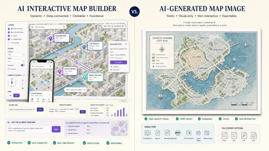
Comparison between a functional interactive map with data and user actions and a static AI-generated map image.

Output AI interactive map builder AI image generator
Real coordinates Expected Not guaranteed
Clickable places Supported by the map product No
Search and filters Possible No
Map navigation Possible No
Layers and datasets Possible No functional data layers
Share or embed Interactive map experience Static image or media asset
Ongoing updates Possible Requires regeneration or manual editing
Analytics Interaction can be measured Image views only unless wrapped in another product
Appropriate use Location discovery, directories, products, operations Illustration, concept art, thumbnails, storytelling images

Readers searching for an AI interactive map builder typically want a working map. Many results for “AI map generator” focus on fantasy maps, map images, or graphic design. Keep that distinction explicit in product copy and evaluation criteria.

Which Product Use Cases Fit Best?

Tourism and destination maps can combine curated destinations, routes, place details, and AI-supported exploration on a designed basemap. See How to Build an AI Tourism Map. Property discovery can combine a listing grid, map, draw-to-search, objective location context, and grounded AI assistance. Retail and store locators can publish branded locations with hours, services, directions, and an optional map concierge; Kaleidr offers retail, hospitality, and property website templates on the Spatial AI product page. Events and community directories can organize places into useful categories, publish a mobile-friendly map, and provide accessible list-based alternatives. SaaS and marketplace products can mount Viewer, Chat, Editor, or Tile inside an application while the host product retains identity, permissions, business logic, and authoritative data. Internal operations maps can use layers, assets, service areas, routes, and live feeds where access controls and source ownership are clear.

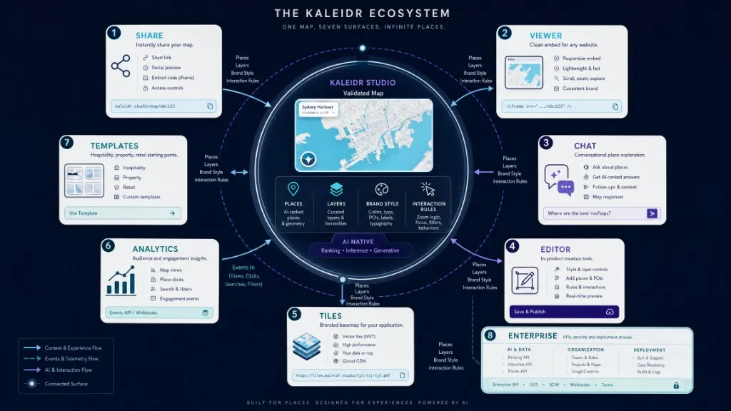
One Kaleidr Studio map expanding into sharing, viewer embedding, AI chat, editing, tiles, analytics, templates, and enterprise integration.

What Pricing and Deployment Paths Apply?

Kaleidr includes AI Map, Studio, and Analytics access on every plan. Free is $0 per month with usage limits for exploring, prototyping, and early maps. Pro is $29 per month with higher usage, API access, publishable and server keys, and embed support for production maps. Enterprise is custom pricing with usage, contracts, SLA, support, and independent CDN options for organization-scale deployment. Pricing was reviewed on 27 July 2026. Confirm the live pricing page before publication or purchase.

How Should Accessibility, Performance, and Attribution Work?

Provide keyboard-accessible controls, maintain visible focus, provide an accessible result list, avoid color-only meaning, label map and chat regions, provide alternatives to drag-only interactions, and test mobile zoom and screen-reader flow. For performance, give the map container a defined height, avoid loading unnecessary layers at startup, cluster dense point data where appropriate, defer secondary media, test slow networks, measure map and interaction readiness separately, and use version-pinned SDK paths. Kaleidr serves embed assets from versioned /embed/v1/ paths and documents that breaking changes ship under a new major path, leaving pinned v1 URLs stable until teams migrate.

Kaleidr's open basemap tiles derive from OpenStreetMap and Overture Maps under open-data licenses. Kaleidr's pricing page states that attribution to OpenStreetMap contributors is required wherever those tiles appear. Additional data, imagery, media, and third-party providers may impose separate attribution and licensing requirements. Preserve required attribution for every source before launch.

Which Events and Metrics Should You Track?

The following event names are editorial recommendations, not claims about automatically emitted Kaleidr Analytics events: ai_map_prompt_submitted, ai_map_draft_created, ai_map_place_removed, ai_map_place_edited, ai_map_layer_added, ai_map_style_changed, ai_map_validation_error, ai_map_published, ai_map_shared, ai_map_viewer_embedded, ai_map_chat_enabled, ai_map_result_selected, ai_map_to_template, and ai_map_to_api_key. Measure the creation and deployment workflow through prompt-to-draft completion, time to first publishable map, percentage of generated places edited or removed, validation-error rate, publish rate, share rate, embed rate, viewer engagement, chat activation, map-result selection, seven-day creator return, and conversion from Studio to API key or Pro plan. Draft volume alone is a weak outcome. Track how many maps are validated, published, embedded, revisited, and used by an audience.

What Mistakes Should Teams Avoid?

Mistake What happens Recommended correction
Prompting only for visual style The output lacks a useful audience task Define audience, geography, content, interaction, and deployment
Treating generated locations as verified Incorrect or stale places reach production Validate every place against an approved source
Adding too many categories The map becomes visually and cognitively dense Keep categories tied to the primary user decision
Using brand color everywhere Application data loses hierarchy Reserve strong color for selected and active states
Publishing without mobile review Panels cover the map or controls become unusable Test common phone widths and touch behavior
Hiding AI-applied changes Users cannot reproduce or correct the result Convert AI changes into visible content, layers, or filters
Assuming the editor persists automatically Work can be lost or disconnected from the host system Implement the documented persistence workflow for the product
Ignoring attribution The deployment can violate data or provider terms Preserve required attribution for every source
Tracking only map opens Traffic is mistaken for product value Measure publish, share, embed, selection, and downstream actions
Using a server key in the browser Backend access becomes public Use an origin-restricted publishable key through the SDK

AI Interactive Map Builder Evaluation Checklist

  • Functional interactive output, not only a generated image
  • Clear prompt-to-map workflow
  • Editable places, labels, content, and categories
  • Human validation controls
  • Custom styling and visual hierarchy
  • Layers and dataset support appropriate to the use case
  • Mobile behavior
  • Accessibility and list alternatives
  • Source attribution
  • Share and publish controls
  • Viewer embed
  • In-product editor path
  • AI chat path
  • Designed basemap path
  • Browser and server credential separation
  • Allowed-domain or origin restrictions
  • Versioned SDK
  • Analytics and event instrumentation
  • Data ownership and retention policy
  • Production pricing and usage model

Final Verdict

An AI interactive map builder is appropriate when a team needs to move from a written concept to a functional map faster without surrendering control over geography, content, brand, interaction, and deployment. Kaleidr’s product continuity is the practical advantage: prompt the concept in Studio, refine places, design, layers, and interaction, publish the map, then extend the same work through Viewer, Chat, Editor, Tiles, Analytics, templates, or the Platform API. The AI-generated draft is only the beginning. A trustworthy map still requires source validation, editorial judgment, accessible interaction, attribution, security, analytics, and a named maintenance owner.

Create an Interactive Map From a Prompt

Describe the map, audience, geography, content, and interaction. Refine the generated structure and publish through Kaleidr Studio. Start Building in Kaleidr Studio for the prompt-first path. Embed a published viewer, add map-aware chat, mount editing tools, or serve a designed basemap through the developer documentation when the map needs to live inside your product.

FAQs

What is an AI interactive map builder?

An AI interactive map builder uses natural-language input to create an editable map structure with real places, layers, styles, and interactions. The result can be refined, shared, published, or embedded as a working map experience.

Can AI create an interactive map from a prompt?

Yes. Kaleidr Studio describes a Prompt → Process → Refine → Deploy workflow in which AI generates and organizes the initial spatial structure before the creator edits content, design, style, and interaction.

Is an AI map builder the same as an AI image generator?

No. An AI image generator creates a visual asset. An AI interactive map builder creates a functional geographic experience with map navigation, clickable content, layers, publishing, and potential analytics.

Do I need coding to create a map with Kaleidr Studio?

Kaleidr Studio is positioned as a prompt-first map creation environment. Coding becomes relevant when a team wants SDK embedding, API integration, a custom host application, or an in-product editor workflow.

Can I customize the map to match my brand?

Yes. Kaleidr Studio describes customization of colors, typography, labels, icons, layers, custom basemaps, terrain, and 3D buildings.

Can I publish and share the map?

Yes. Kaleidr product pages describe sharing and deployment across digital platforms. A published map can also be embedded through the Viewer product by share ID.

Does the Kaleidr Viewer require an API key?

No. Viewer documentation states that published-map access is share-link gated. Publisher-defined allowed domains can still restrict where the map renders. Keys are required for Chat, Editor, and Tile embeds.

Can I embed map editing inside my own application?

Yes. Kaleidr Editor can mount editing tools inside another application. The standalone embed uses an in-memory specification and does not persist edits automatically, so teams must evaluate the host and backend workflow.

Can I add AI chat to the finished map?

Yes. Kaleidr Chat can attach map-aware AI interaction to supported Mapbox, Google Maps, and MapLibre implementations, and Kaleidr templates can include AI chat in a published website experience.

What plan do I need for embedding and API access?

Kaleidr pricing lists developer API access, publishable and server keys, and embed support with Pro and Enterprise plans. Free includes Studio, AI Map, and Analytics access under lower usage limits. Viewer embedding of a published map remains share-link gated without a key.

How should I verify an AI-generated map?

Check every place, coordinate, source, description, category, layer, attribution requirement, mobile layout, accessibility state, and user action before publication. Operational fields should always come from an authoritative source.

References

@misc{kaleidr_studio,
  title  = {Create Custom Maps with AI Map Maker},
  author = {{Kaleidr}},
  note   = {Accessed 27 July 2026},
  url    = {https://kaleidr.com/studio}
}

@misc{kaleidr_ai,
  title  = {AI Maps You Can Talk To -- Spatial AI},
  author = {{Kaleidr}},
  note   = {Accessed 27 July 2026},
  url    = {https://kaleidr.com/ai}
}

@misc{kaleidr_viewer,
  title  = {Viewer -- embed a published map},
  author = {{Kaleidr}},
  note   = {Kaleidr Developer Docs; accessed 27 July 2026},
  url    = {https://docs.kaleidr.com/sdk/viewer-embed}
}

@misc{kaleidr_editor,
  title  = {Editor -- mount the map editor},
  author = {{Kaleidr}},
  note   = {Kaleidr Developer Docs; accessed 27 July 2026},
  url    = {https://docs.kaleidr.com/sdk/editor-attach}
}

@misc{kaleidr_pricing,
  title  = {Pricing \& Plans},
  author = {{Kaleidr}},
  note   = {Accessed 27 July 2026},
  url    = {https://kaleidr.com/pricing}
}

@misc{kaleidr_cdn_versioning,
  title  = {CDN versioning},
  author = {{Kaleidr}},
  note   = {Kaleidr Developer Docs; accessed 27 July 2026},
  url    = {https://docs.kaleidr.com/reference/cdn-versioning}
}

@misc{wcag22,
  title  = {Web Content Accessibility Guidelines (WCAG) 2.2},
  author = {{World Wide Web Consortium}},
  note   = {Accessed 27 July 2026},
  url    = {https://www.w3.org/TR/WCAG22/}
}