
Un fond de carte personnalisé constitue la base visuelle sous les lieux, itinéraires, limites et données en temps réel d’un produit. Sa conception exige une hiérarchie claire, des libellés lisibles, une accessibilité adaptée aux différents thèmes, un rendu efficace et une attribution correcte des sources ; il ne suffit pas d’appliquer la couleur de la marque à chaque route. Kaleidr Studio permet de concevoir les tuiles, les couleurs, la typographie, les libellés, les icônes, les couches, le relief et des préréglages réutilisables. Le SDK Kaleidr peut ensuite intégrer le fond de carte ou charger directement le style publié dans MapLibre.
Les sections suivantes vont de la tâche produit et des jetons de conception à la hiérarchie des couches, la typographie, les icônes, le relief, le flux de travail Studio, deux méthodes de déploiement, les licences, l’accessibilité et les contrôles de publication. Suivez l’ensemble de la démarche pour préparer un style de production ; si la conception est déjà terminée, passez directement à l’option 1 ou à l’option 2.
Qu’est-ce qu’un fond de carte personnalisé de marque ?
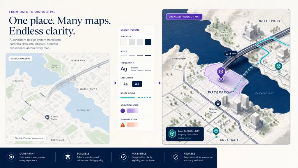
Une carte de base est le canevas géographique sous les informations spécifiques au produit dans une carte. La carte de base contient normalement des éléments de référence tels que la terre et l'eau, les routes et les sentiers, les bâtiments, les parcs et l'utilisation des terres, les limites administratives, les libellés de lieux et de routes, le terrain ou la colline, et les points d'intérêt sélectionnés pour le contexte. Une carte de base de marque applique un système de conception délibéré à ces caractéristiques afin que la carte appartient visuellement au produit environnant. Le résultat devrait être conforme aux couleurs, au type, à l'espacement, au ton et aux priorités d'information de l'application sans sacrifier la lisibilité géographique.
La MapLibre Style Specification définit un style de carte comme un document JSON qui contrôle les données à dessiner, l'ordre dans lequel le dessiner et la façon dont le renderer doit le visualiser. Les sources identifient les données disponibles; les couches font référence à ces sources et définissent des propriétés visuelles telles que la couleur, la largeur, l'opacité, les icônes et le texte. Ce modèle fait d'une carte de base de marque un actif de produit réutilisable plutôt qu'une collection de couleurs de marqueurs ad hoc.
Quelle est la différence entre fond de carte, superpositions et données applicatives ?
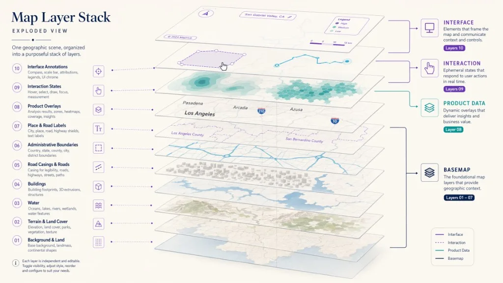
Une carte fiable sépare la géographie de référence de l'information que les utilisateurs sont venus voir. La carte de base fournit un contexte géographique stable. Les superpositions de produits représentent le sujet de l'application. Les couches d'interaction montrent l'état temporaire de l'utilisateur ou du système. Les couches d'interface supportent les contrôles et les explications. La carte de base doit généralement être plus silencieuse que la superposition du produit, de sorte que les données opérationnelles restent dominantes.
| Type de couche | But | Exemples |
|---|---|---|
| fond de carte | Fournit un contexte géographique stable | Routes, eau, bâtiments, parcs, libellés, limites |
| se superposition de produit | Représente le sujet de la demande | Propriétés, magasins, incidents, actifs, zones de service, itinéraires |
| couche d'interaction | Affiche l'état temporaire de l'utilisateur ou du système | Lieu sélectionné, état de survol, résultat d'IA, polygone de recherche, aperçu de l'itinéraire |
| Couchez une couche d' | Soutient les contrôles et les explications | Légende, filtres, panneau de discussion, infobulles, attribution, messages d'état |
Une plate-forme immobilière peut mettre en sourdine les bâtiments ordinaires afin que les inscriptions actives se démarquent. Un produit de mobilité peut mettre l'accent sur la hiérarchie routière tout en réduisant les points d'intérêt non liés. Un guide touristique peut préserver les points de repère et le contexte piétonnier tout en utilisant un traitement visuel plus fort pour les destinations organisées. L’image de marque devient utile lorsqu’elle améliore cette hiérarchie; une carte qui utilise simplement plus de couleur de marque peut devenir plus difficile à lire.
Qu’allez-vous créer ?
Ce guide produit un flux de travail de carte de base de marque réutilisable avec un brief de conception lié à la tâche de carte réelle du produit, un système de jetons contrôlé pour la couleur, la typographie, les libellés, les lignes et les surfaces, une hiérarchie de couches qui maintient les données d'application dominantes, les tests de lumière, sombres et à contraste élevé, l'attribution OpenStreetMap et les vérifications de livraison de tuiles, une option d'intégration hébergée par Kaleidr.
Kaleidr documente actuellement cinq identifiants de style intégrés pour son produit de carte de base conçu: kaleidr-morning, kaleidr-afternoon, kaleidr-night, kaleidr-editorial et kaleidr-plain. Kaleidr Studio décrit séparément les couleurs personnalisées, la typographie, les libellés, les icônes, les jeux de données, les superpositions, les préréglables réutilisables, le terrain, les bâtiments 3D et les collines. La documentation du développeur public montre comment servir un style conçu, mais elle ne documente pas chaque étape de publication Studio pour les identifiants de style personnalisés spécifiques à l'organisation. Confirmez le flux de travail et l'identifiant de publication final à l'intérieur de l'interface Studio actuelle avant le déploiement de la production.
Comment partir de la tâche produit ?
Une carte de base forte commence par une décision de produit, pas un séleveur de couleurs. Demandez quelle est la tâche principale de l'utilisateur, quelles fonctionnalités géographiques aident à terminer cette tâche, qui comporte des caractéristiques qui en détournent l'attention, quelles informations doivent rester lisibles à chaque zoom, quelles superpositions de produit ont besoin du contraste le plus fort, si la carte apparaît à côté d'une interface dense chromée ou comme une expérience en plein écran, si le même style doit servir le bureau, les captures d'écran mobiles, les captures d'écran et les vues intégrées, et si le produit a besoin de jour, nuit ou accessibilité. Un localisateur de magasin et un tableau de bord logistique ne doivent pas partager le même accent géographique simplement parce qu’ils partagent un logo.
Pour un localisateur de magasin, priorisez les routes principales et locales, les libellés de quartier et de ville, les points de repère reconnaissables, les marqueurs de magasin clairs et le contexte de l'itinéraire, tout en réduisant les catégories mineures d'utilisation des terres, les libellés d'affaires non liées, le terrain décoratif et l'accent détaillé sur le bâtiment à petites échelles. Pour la découverte immobilière, priorisez les noms de quartier, le transport en commun, les parcs et l'eau, la hiérarchie de la rue, les empreintes de construction à un zoom rapproché, et les superpositions de propriété ou de recherche. Pour un tableau de bord d'opérations, priorisez les routes, les zones de service, les limites administratives et le contexte des actifs, avec des surfaces sombres ou à faible chromate qui supportent les couleurs d'alerte, les états sélectionnés et non sélectionnés clairs et les libellés stables qui ne masquent pas les marqueurs incidents.
Comment définir un système de jetons de conception cartographique ?
Créez des jetons de carte avant d'éditer des calques individuels. Les jetons maintiennent le style cohérent et rendent les futures variantes plus faciles à entretenir. Un ensemble de jetons pratiques comprend des surfaces, des réseaux, des libellés et des accents opérationnels:
map.background
map.land
map.water
map.park
map.building
map.boundary
map.road.motorway
map.road.primary
map.road.secondary
map.road.local
map.road.casing
map.label.country
map.label.city
map.label.neighborhood
map.label.road
map.label.poi
map.label.halo
map.overlay.primary
map.overlay.secondary
map.selection
map.warning
map.route
Ne pas maper tous les jetons directement à une couleur de marketing d'entreprise. Les systèmes de marque de produits comprennent souvent des couleurs conçues pour les boutons ou les illustrations qui échouent sur une toile géographique dense. Utilisez les couleurs de marque de manière sélective pour les superpositions de produits actifs, les caractéristiques sélectionnées, les itinéraires, les zones de recherche, les appels principaux à l'action et un petit nombre de fonctionnalités de référence significatives. Utilisez des couleurs neutres limitées pour la plupart des géographies de référence.
Comment construire la hiérarchie visuelle ?
La spécification de style MapLibre répertorie les calques dans l'ordre de dessin. Les couches ultérieures dessinent généralement au-dessus des couches antérieures, de sorte que l'ordre des couches fait partie de l'architecture de l'information. Une carte de base commune place le fond, la couverture terrestre et le terrain, l'eau, les parcs et l'utilisation des terres, les bâtiments, les routes et les boyaux de route, les limites, les libellés des lieux, les libellés de route et les points d'intérêt contextuels sous les superpositions de produits et les états d'interaction. L'ordre exact dépend du rendu et du style, mais le principe reste stable: de grandes surfaces géographiques se trouvent sous les réseaux, les libellés et les informations spécifiques au produit.
Chaque couche n'a pas besoin d'égale saturation, opacité ou détail. Les contrôles utiles comprennent l'abaissement de l'opacité des polygones de faible priorité, la réduction du contraste mineur-route à de petits zooms, la cachet des points d'intérêt de faible valeur, la démonstration d'empreintes de construction seulement après un seuil de zoom utile, la limitation des limites administratives aux échelles où ils aident l'orientation et le retard de l'étiquette de rue locale jusqu'à ce que l'utilisateur soit suffisamment proche pour en avoir besoin. Une carte de base silencieuse augmente la clarté perçue des données d'application sans rendre la carte vide.
Le style routier nécessite généralement à la fois une hiérarchie et un boîtier. Envisager l'autoroute à travers les classes de service, la largeur par zoom, le boîtier de ligne sous le remplissage de la route, les tunnels et les ponts, les rampes et les routes divisées, les chemins piétons et les pistes cyclables, et la densité de l'étiquette. Une couleur de marque appliquée à chaque route crée un réseau plat dans lequel rien n’apparaît plus important que toute autre chose. Utilisez la largeur, la luminosité, le boîtier et les changements de teinte contrôlés pour établir la hiérarchie, et ne révélez les routes locales qu'à des échelles plus rapprochées.
Comment concevoir les libellés, les icônes et les contrastes ?
La typographie est l'un des signaux de marque les plus forts d'une carte, mais le rendu de l'étiquette a des contraintes techniques. Un document de style peut référencer les ressources glyphiques via un modèle d'URL. La spécification de style MapLibre nécessite des URL glyph pour inclure les espaces réservés {fontstack} et {range}, tandis que les ressources de sprite fournissent des icônes et des modèles référencés par les couches de symboles. Une police nommée dans un système de conception n'est pas automatiquement disponible pour le rendu de la carte; l'ensemble de glyphe doit être servi dans le format et la couverture attendus par le style.
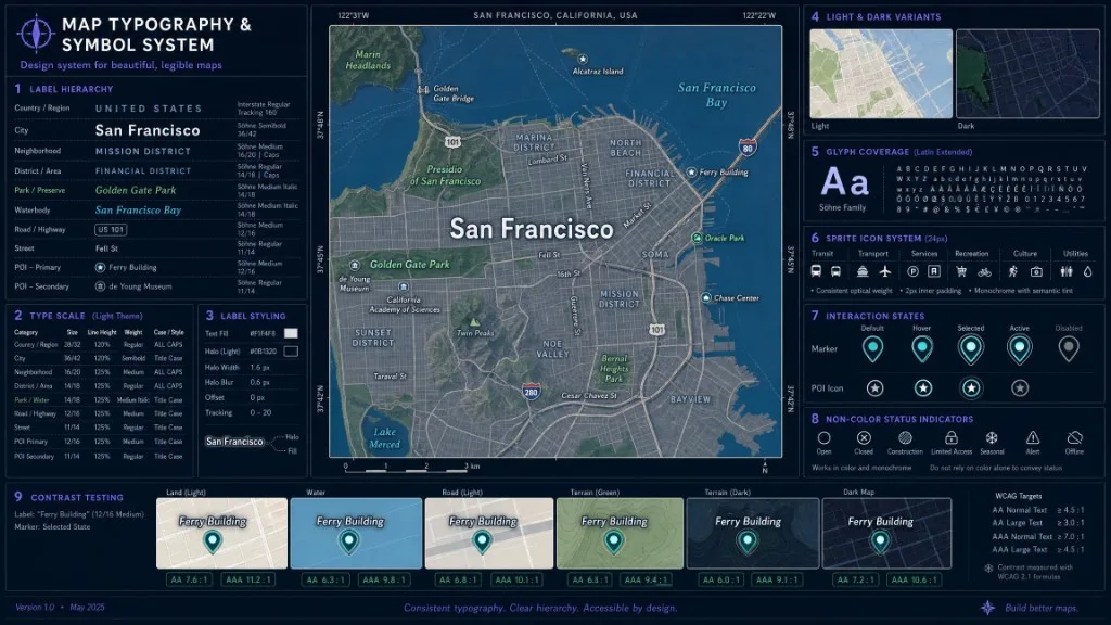
Définissez les rôles d'étiquette plutôt que d'appliquer une taille de police partout: pays, région ou état, ville, quartier, route, transit, point d'intérêt, plan d'eau et annotation de produit. Utilisez la taille et le poids pour la hiérarchie, l'espacement des lettres restreints, les halos pour le contraste sur l'évolution de la géographie, les différentes couleurs pour l'eau, l'administration et les libellés de route lorsque cela est utile, les seuils de zoom qui empêchent le crowding, et la couverture du langage et du script approprié au public. Teste les libellés sur les régions les plus claires et les plus sombres de la carte, car une étiquette qui semble correcte sur la terre peut disparaître au-dessus de l'eau, du terrain ou d'une couche satellite.
Les icônes de carte doivent fonctionner comme un système de symboles compacts. La spécification MapLibre sprite utilise des ressources d'image et de métadonnées de sprite pour mettre des icônes et des modèles à la disposition des couches de symboles et de remplissage. Avant d'ajouter des icônes de marque, définissez un style de trait et de remplissage cohérent, une taille minimale rendue, des variantes claires et sombres, des états sélectionnés et non sélectionnés, une signification sémantique, des règles de collision et de chevauchement, et des équivalents de texte accessibles en dehors du canevas. Ne forcez pas le logo de l'entreprise dans tous les marqueurs de point d'intérêt. La répétition réduit la clarté de la carte et peut rendre l'interface promotionnelle plutôt que fonctionnelle.
Quand faut-il ajouter le relief et la 3D ?
Kaleidr Studio décrit le soutien à l'élévation, au terrain, aux collines et aux bâtiments extrudés. MapLibre documente également les couches de terrain et de fill-extrusion pour les bâtiments 3D. Utilisez ces capacités lorsqu'elles améliorent la compréhension spatiale de l'utilisateur: terrain pour l'extérieur, la mobilité, l'infrastructure et les flux de travail à risque; collines pour le contexte de relief; bâtiments 3D pour l'orientation urbaine à grande échelle; et extrusions pour la hauteur ou le volume qui compte pour la tâche. Évitez la 3D lorsqu'elle obscurcit les marqueurs, augmente le bruit visuel, crée une charge GPU inutile, rend les libellés plus difficiles à lire ou implique la précision que les données sources ne supportent pas. Une carte de marque n'est pas plus forte simplement parce qu'elle est plus dimensionnelle.
La carte de base et les données de l'application doivent rester séparées chaque fois que possible. Les sources MapLibre indiquent quelles données la carte doit afficher, tandis que les calques définissent comment rendre ces données. La même source peut supporter plusieurs couches visuelles, telles qu'un remplissage de polygone, un contour, l'état sélectionné et l'étiquette. Pour les superpositions de produits, définissez la propriété de la source, les identifiants stables, le type de géométrie, la fréquence de mise à jour, la plage de zoom, les règles de filtrage, les états sélectionnés et de survol, les états d'erreur et de vide, et les contraintes de confidentialité. Gardez les couleurs opérationnelles distinctes des couleurs de la carte de base afin qu'une alerte rouge ne concurrence pas les routes rouges et qu'une région sélectionnée en bleu ne disparaisse pas dans l'eau bleue.
Comment créer le fond de carte dans Kaleidr Studio ?
Kaleidr Studio utilise un Prompt → Process → Affiner → Déployer un flux de travail et décrit les contrôles personnalisés de conception, de contenu, de style et d'interaction. Pour une carte de base de marque, définissez l'objectif de la carte, choisissez une direction visuelle, définissez les couleurs et la hiérarchie, configurez la typographie et les libellés, ajoutez ou réutilisez des couches, évaluez le terrain et la 3D uniquement lorsqu'ils améliorent la compréhension, testez les emplacements et les zooms représentatifs, publiez la carte de base conçue et intégrez ou chargez le style. La page publique Studio de Kaleidr confirme les zones de conception disponibles, mais les contrôles de publication spécifiques à l'organisation peuvent évoluer. Enregistrer des captures d'écran et l'identifiant de style final dans le cadre du processus de publication.
Quelle méthode de déploiement choisir ?
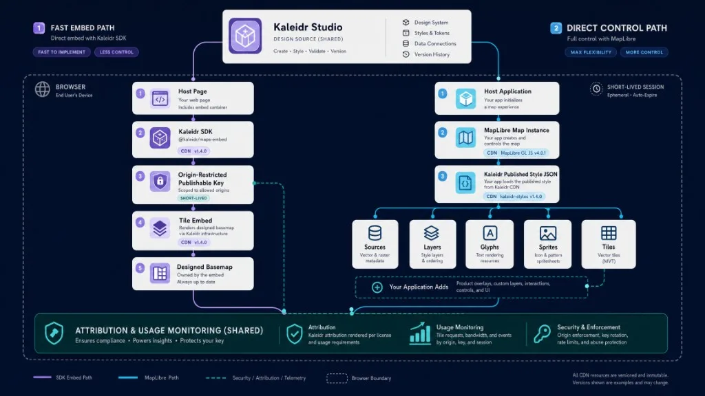
Kaleidr documente deux modèles de mise en œuvre pour une carte de base conçue. L'intégration de tuile possède sa propre surface de carte et reçoit les mises à jour de la caméra via l'interface d'intégration du SDK. Direct MapLibre charge les points d'une carte appartenant à l'hôte au style publié JSON afin que l'application puisse ajouter ses propres sources, couches et interactions. Choisissez l'intégration lorsque la vitesse de mise en œuvre est importante et que la carte de base peut posséder sa surface. Choisissez MapLibre lorsque l'hôte a besoin d'un contrôle de rendu complet.
Option 1 : intégrer le fond de carte Kaleidr
L'exemple suivant est adapté de la documentation officielle actuelle. Utilisez une clé publiable limitée aux origines autorisées; le SDK échange la clé pour une session d'origine de courte durée. La clé nécessite la possibilité de capacité de maps pour les tuiles. Les clés API sont actuellement incluses dans les plans Pro et Enterprise. Voir Obtenir une clé API et Tiles — intégrer une carte de base conçue.
<script src="https://cdn.kaleidr.com/embed/v1/kaleidr.js"></script>

<kaleidr-map
  product="tile"
  publishable-key="YOUR_PUBLISHABLE_KEY"
  style-id="kaleidr-morning"
  center="-0.12,51.5"
  zoom="11"
  style="height: 480px">
</kaleidr-map>
Les identifiants de style intégrés actuels sont kaleidr-morning, kaleidr-afternoon, kaleidr-night, kaleidr-editorial et kaleidr-plain. Utilisez l'option d'intégration lorsque la carte de base peut posséder sa propre surface de carte, la vitesse de mise en œuvre compte, l'application peut communiquer via l'interface d'intégration documentée, et l'équipe n'a pas besoin d'assez directement sur chaque méthode de rendu.
Option 2 : charger le style directement dans MapLibre
Kaleidr documente également en utilisant la même carte de base directement dans une carte MapLibre appartenant à l'hôte via son style publié JSON. L'URL de style et l'identifiant intégré ci-dessous proviennent du guide actuel Utilisation d'une carte de base conçue. Pour un style personnalisé spécifique à l'organisation, remplacez l'URL de style publiée documentée par le flux de travail Studio actuel.
<link
  href="https://unpkg.com/maplibre-gl@6.0.0/dist/maplibre-gl.css"
  rel="stylesheet"
/>

<div id="map" aria-label="Branded interactive map"></div>

<script type="module">
  import * as maplibregl
    from "https://unpkg.com/maplibre-gl@6.0.0/dist/maplibre-gl.mjs";

  const map = new maplibregl.Map({
    container: "map",
    style: "https://cdn.kaleidr.com/styles/kaleidr-morning.json",
    center: [-0.12, 51.5],
    zoom: 11
  });

  map.addControl(new maplibregl.NavigationControl());

  map.on("error", (event) => {
    console.error("Basemap or renderer error:", event.error ?? event);
  });
</script>
Utilisez l'option MapLibre directe lorsque l'application hôte a besoin d'un accès direct à l'instance de la carte, que les superpositions de produits doivent être ajoutées en tant que sources et couches, l'équipe a besoin d'un contrôle précis sur les événements, la caméra, les commandes et le style d'exécution, ou la carte de base fait partie d'une application interactive plus grande.
Comment versionner et mettre l’intégration en cache ?
Kaleidr dessert le chargeur et les faisceaux de produits via des chemins à épingles de version tels que https://cdn.kaleidr.com/embed/v1/kaleidr.js et https://cdn.kaleidr.com/embed/v1/tile.js. Les mises à jour rétrocompatibles s'expédient sous le même chemin majeur. Un changement d'intégration ou de message post-Message utiliserait un nouveau chemin majeur tel que /embed/v2/. Kaleidr déconseille l'empreinte digitale ou l'auto-hébergement des bundles SDK à moins que l'équipe n'ait l'intention d'épingler une construction spécifique indépendamment. Voir Versionnement CDN.
Les actifs et les tuiles de style devraient également utiliser une stratégie de cache et de version explicite: version changements de style significatifs, éviter de remplacer un style de production sans test de régression, enregistrer l'ID et la date de style publiés, l'invalidation du sprite de test et du cache de glyphe, préserver une cible de recul et surveiller les requêtes de style, de tuile, de sprite et de glyphe.
Quelles règles d’attribution et d’utilisation des tuiles s’appliquent ?
Les données OpenStreetMap sont des données ouvertes, mais l'attribution reste nécessaire. OpenStreetMap déclare que les utilisateurs peuvent utiliser les données à n'importe quelle fin tant qu'ils créditent OpenStreetMap et ses contributeurs. La page de tarification de Kaleidr indique que ses données de carte de base ouvertes proviennent d'OpenStreetMap et d'Overture Maps et nécessite l'attribution aux contributeurs d'OpenStreetMap partout où les tuiles apparaissent. Voir la page de copyright OpenStreetMap; la Fondation OpenStreetMap publie également des directives d'attribution pour les cartes interactives et autres œuvres produites.
Ne confondez pas les données ouvertes avec l'utilisation illimitée des serveurs de tuiles publiques de la Fondation OpenStreetMap. La politique d'utilisation des tuiles OSMF explique que le service de tuiles raster publiques a une capacité limitée et impose des exigences d'utilisation. Un produit de production devrait utiliser un fournisseur, un service de tuiles hébergés conforme ou une infrastructure auto-hébergée plutôt que de traiter tile.openstreetmap.org comme un RNC commercial gratuit.
Pour chaque version, vérifiez que l'attribution reste visible et lisible, le lien d'attribution pointe vers la page de licence ou de droit d'auteur requise, tout ensemble de données ou crédits d'imagerie supplémentaires sont présents, les images satellitaires et hybrides suivent leurs licences commerciales distinctes, et les termes de stockage, de mise en cache et de redistribution du fournisseur sont respectés. Kaleidr déclare actuellement que ses tuiles de carte de base ouvertes basées sur OpenStreetMap peuvent être utilisées commercialement dans le cadre de l'allocation mensuelle de charge de carte du plan. Les images satellite et hybrides sont des couches sous licence distinctes et ne sont pas incluses dans l'offre de tuiles ouvertes.
Comment tester l’accessibilité et les performances ?
Un canevas de carte ne doit pas être le seul endroit où l'information essentielle apparaît. Étiquette d'essai contraste sur la terre, l'eau, les routes, les bâtiments et le terrain; contraste de superposition avec chaque variante de carte de base; états sélectionnés et non sélectionnés sans dépendre de la couleur seule; visibilité de l'itinéraire et des limites pour les lacunes courantes de vision de la couleur; accès au clavier aux commandes et aux listes de résultats; équivalents de lecture d'écran pour les marqueurs et les caractéristiques sélectionnées; attribution lisible et libellés de contrôle; et comportement à mouvement réduit pour les transitions de caméra, le cas échéant. Utilisez de véritables captures d'écran lors de zooms représentatifs, car les vérifications de contraste d'interface génériques ne capturent pas chaque arrière-plan qu'une étiquette ou un marqueur peut franchir.
Un style personnalisé peut affecter les performances de démarrage et d'interaction grâce au style JSON, au nombre de sources, au nombre et à la complexité des couches, aux demandes de glyphe et de sprite, à la taille des tuiles et au comportement du cache, au rendu du terrain et à la 3D, au travail de collision de l'étiquette, aux superpositions en direct ou fréquemment mises à jour et aux limitations du GPU de l'appareil. Mesurez le temps jusqu'à ce que la première carte utile apparaisse, le temps de chargement du style, les requêtes de tuiles, de glyph et de sprites, la fréquence d'image pendant le panoramique, le zoom, le pitch et la rotation, l'utilisation de la mémoire sur les appareils mobiles représentatifs, l'impact des superpositions en direct et l'utilisation de la charge de carte et de la tuile par session. Supprimer les couches cachées ou redontantes plutôt que de supposer que le rendu les rend libres.
Quels contrôles qualité inclure dans la publication ?
Testez la carte de base à travers la géographie, l'échelle, le thème et l'état du produit avant d'approuver une version. Un style ne doit pas être approuvé en fonction d'une capture d'écran attrayante de la ville.
| Dimension d'essai | Cas requis |
|---|---|
| Géographie | Dense urbain, banlieue, rural, côtier, montagneux, international |
| Zoom | Régional, ville, quartier, rue, immeuble |
| Thème | Lumineux, sombre, contraste élevé, variante de campagne de marque |
| État des données | Pas de superpositions, résultats normaux, résultats denses, résultat sélectionné, itinéraire, alerte |
| Dispositif | Ordinateur de bureau, tablette, mobile bas de gamme, écran haute densité |
| Réseau | Rapide, lent, intermittent, mis en cache, démarrage à froid |
| Langue | Noms de lieux longs, plusieurs scripts, droite à gauche lorsque pris en charge |
| Accessibilité | Clavier, lecteur d'écran, simulation de vision couleur, texte zoomé |
Les noms d'événements suivants sont des recommandations éditoriales plutôt que des affirmations sur les événements Kaleidr Analytics émis automatiquement:
basemap_loaded
basemap_load_failed
basemap_style_selected
basemap_style_changed
basemap_theme_changed
basemap_tile_error
basemap_attribution_opened
map_overlay_added
map_overlay_toggled
map_3d_enabled
map_session_completed
Les métriques utiles incluent le premier temps de carte utile, le taux de charge de style réussi, le taux d'erreur de tuile, l'utilisation de la charge de carte, la fréquence d'image du rendu, la durée de la session, le taux d'interaction de superposition, le taux de résultat sélectionné, l'achèvement de la route ou du flux de travail, la fréquence de changement de thème, la conversion par variante de carte de base et les incidents de support liés à la lisibilité de la carte. Ne déclarez pas une carte de base réussie parce qu'elle semble distinctive. Mesurer si les utilisateurs trouvent, interprètent et agissent plus efficacement sur l'information géographique du produit.
Quelles erreurs les équipes doivent-elles éviter ?
| Errur | Que se passe-ce | Correction recommandée |
|---|---|---|
| Appliquer la couleur de marque partout | La hiérarchie géographique s'effondre | Réservez une couleur de marque forte pour les caractéristiques sélectionnées et les superpositions de produits |
| Styler la carte de base avant de définir la tâche | La carte semble polie mais ne supporte pas le flux de travail | Commencez par les décisions des utilisateurs et le contexte géographique requis |
| Garder chaque étiquette de point d'intérêt | Les données importantes sur les produits sont en concurrence avec des libellés non liées | Supprimer ou retarder les libellés de faible valeur par zoom et catégorie |
| Utilisation d'une police d'entreprise sans support glyphique | Les libellés échouent ou se rabattent de manière incohérente | Confirmer l'hébergement glyphe, la couverture des personnages et la compatibilité du rendu |
| Traiter les icônes comme de la décoration | Les symboles deviennent incohérents et ambigus | Créer un système de sprite sémantique avec des états et des équivalents de texte |
| Ajout de 3D par défaut | La performance et la lisibilité diminue | Utilisez le terrain et les extrusions uniquement lorsqu'elles expliquent la structure pertinente |
| Mélanger les couleurs de superposition et de carte de base | Les états sélectionnés ou alertes disparaissent | Maintenir des jetons de couleur de référence et opérationnels séparés |
| Supprimer l'attribution | La carte viole les exigences de la source | Gardez l'attribution lisible liée à la source et la licence requises |
| Utilisation de serveurs de tuiles OSM publics comme CDN de production | L'utilisation peut violer la politique ou être bloquée | Utilisez un fournisseur conforme, des tuiles hébergées par Kaleidr ou une infrastructure auto-hébergée |
| Remplacer un style de production sans version | Les régressions visuelles atteignent les utilisateurs sans rollback | Versions et préservation d'un style précédent testé |
Liste de contrôle finale de mise en œuvre
- Équipe de carte de produit documentée
- fond de carte, superposition, interaction et couches d'interface séparées
- La hiérarchie géographique définie
- Les jetons de conception de carte approuvés
- Classes routières testes par zoom
- Hiérarche de l'étiquette et halos testés
- Couverture du glyphe confirmée
- Système de sprite et d'icônes documenté
- Couleurs de superposition de produit maintenues distinctes
- Terrain et 3D justifiés par le cas d'usage
- Les sites mondiaux représentatifs examinés
- Variantes claires, sombres et d'accessibilité testées
- OpenStreetMap et autre attribution visible
- Termes de fournisseurs de tuiles confirmés
- Limites d'origine de clés publiables configurées
- Portabilité de
mapsconfirmée - Intégrer ou diriger le chemin MapLibre sélectionné
- Style ID et version enregistrée
- Erreur et chargement des états mis en œuvre
- Performances testées sur matériel mobile
- Carte-charge et utilisation des tuiles surveillées
- Style Rollback conservé
Verdict final
Une carte de base de marque personnalisée devrait faire en sorte qu'une carte se sente native du produit tout en améliorant la hiérarchie des informations dont les utilisateurs ont besoin. La couleur, la typographie, les libellés, les icônes, le terrain et la 3D sont des outils de mise en œuvre, et non l’objectif. Le flux de travail le plus solide commence par la tâche du produit, sépare la géographie de référence des superpositions opérationnelles, définit des jetons de conception réutilisables, teste plusieurs emplacements et zooms, préserve l'attribution de la source et se déploie via un style versionné et un chemin de livraison de tuiles.
Kaleidr prend en charge deux modèles de mise en œuvre documentés: intégrer une carte de base conçue avec product="tile", ou charger le style Kaleidr publié JSON directement dans une carte MapLibre. Utilisez l'intégration lorsque la carte de base peut posséder sa surface et la vitesse d'intégration est importante. Utilisez le chemin d'accès MapLibre direct lorsque l'application hôte a besoin d'un contrôle complet de la carte et doit ajouter ses propres sources, couches et interactions.
Concevez un fond de carte dans Kaleidr Studio
Créez des styles de carte, des libellés, des couches, du terrain, des bâtiments 3D et des préréglages réutilisables pour une expérience spatiale de marque. Commencez à partir de la tâche du produit, appliquez des jetons de manière sélective et publiez un style que vous pouvez intégrer ou charger dans MapLibre.
Ajoutez le fond de carte conçu à votre produit
Passez en revue l'intégration de la tuile, l'URL de style MapLibre, la clé du navigateur, la restriction d'origine, l'utilisation et la documentation de version CDN avant de sélectionner le chemin d'intégration.
Lire la documentation de la carrelage Kaleidr
Questions fréquentes
Qu’est-ce qu’un fond de carte personnalisé de marque ?
Une carte de base de marque personnalisée est un style de référence géographique réutilisable dont les couleurs, la typographie, les libellés, les icônes, les routes, les surfaces et les couches contextuelles sont conçus pour s'adapter au système visuel et à la tâche utilisateur d'un produit. La carte de base fournit le contexte; les superpositions de produits portent le sujet de l'application.
Un fond de carte est-il identique aux données de mon application ?
Non. La carte de base fournit un contexte géographique tel que les routes, l'eau, les bâtiments et les libellés. Les données de l'application représentent les propriétés, les magasins, les actifs, les incidents, les itinéraires ou d'autres sujets du produit et devraient normalement apparaître au-dessus de la carte de base.
Puis-je utiliser la police de ma marque sur une carte vectorielle ?
Ce n'est que lorsque le renderer peut charger des ressources glyph compatibles pour la police et les plages de caractères requises. Confirmer la licence, la génération de glyphes, l'hébergement, la couverture linguistique et le comportement de repli avant de choisir la police de caractères.
Les fonds de carte Kaleidr peuvent-ils être utilisés dans MapLibre ?
Oui. Les documents Kaleidr chargeant un modèle de Kaleidr publié JSON directement comme valeur style lors de la création d'une carte MapLibre. L'application hôte ajoute ensuite ses propres superpositions et interactions au-dessus de ce style.
Puis-je intégrer un fond de carte Kaleidr sans gérer directement MapLibre ?
Oui. Le SDK Kaleidr documente un élément personnalisé product="tile" et une option de montage impérative qui intègre une carte de base conçue par ID de style. L'intégration possède sa propre surface de carte et communique à travers l'interface documentée.
Quels styles de fond de carte Kaleidr sont actuellement documentés ?
La documentation actuelle du développeur répertorie kaleidr-morning, kaleidr-afternoon, kaleidr-night, kaleidr-editorial et kaleidr-plain. Les styles Studio spécifiques à l'organisation peuvent être publiés sous des identifiants supplémentaires.
Les tuiles Kaleidr nécessitent-elles une clé API ?
Les intégrations de tuiles de navigateur utilisent une clé Kaleidr publiable avec la capacité de carte appropriée et les restrictions d'origine autorisées. Les clés API sont actuellement incluses dans les plans Pro et Enterprise.
Puis-je utiliser commercialement les tuiles de fond de carte ouvert de Kaleidr ?
La page de tarification actuelle de Kaleidr indique que l'utilisation commerciale est autorisée dans l'allocation de charge de carte mensuelle. L'utilisation de la production à volume plus élevé est incluse avec Pro, et Enterprise prend en charge le volume personnalisé via un CDN indépendant. Les images satellite et hybrides restent sous licence séparée.
Dois-je attribuer OpenStreetMap ?
Oui. OpenStreetMap exige l'attribution à OpenStreetMap et à ses contributeurs. Kaleidr déclare également que l'attribution est requise partout où ses tuiles ouvertes basées sur OpenStreetMap apparaissent. Gardez le crédit visible et lié aux informations sur le droit d'auteur ou la licence.
Puis-je utiliser les serveurs publics de tuiles OpenStreetMap pour un produit commercial ?
Les données OpenStreetMap sont ouvertes, mais les serveurs de tuiles publiques de la Fondation OpenStreetMap ont une politique d'utilisation distincte et une capacité de don limitée. Une application de production devrait utiliser un fournisseur de tuiles conforme ou une infrastructure auto-hébergée plutôt que d'assumer une utilisation illimitée de RNC.
Toutes les cartes de marque doivent-elles utiliser le relief et des bâtiments 3D ?
Non. Terrain et 3D doivent être utilisés lorsqu'ils améliorent la compréhension spatiale. Ils peuvent réduire la lisibilité et les performances lorsqu'ils ne supportent pas la tâche de l'utilisateur.
Comment mesurer l’efficacité du fond de carte ?
Mesurez la fiabilité de la charge de style, le premier temps de carte utile, les erreurs de tuile, l'interaction de superposition, la sélection des résultats, l'achèvement du flux de travail, les problèmes d'accessibilité, les incidents de support et la conversion. Le caractère distinctif visuel seul n'est pas une mesure de succès suffisante.
Références
- Kaleidr. CDN versioning. Kaleidr Developer Docs. Accessed 25 July 2026. https://docs.kaleidr.com/reference/cdn-versioning
- Kaleidr. Create Custom Maps with AI Map Maker. kaleidr.com. Accessed 25 July 2026. https://kaleidr.com/studio
- Kaleidr. Get an API key. Kaleidr Developer Docs. Accessed 25 July 2026. https://docs.kaleidr.com/get-an-api-key
- Kaleidr. Introduction. Kaleidr Developer Docs. Accessed 25 July 2026. https://docs.kaleidr.com
- Kaleidr. Pricing & Plans. kaleidr.com. Accessed 25 July 2026. https://kaleidr.com/pricing
- Kaleidr. Tiles — embed a designed basemap. Kaleidr Developer Docs. Accessed 25 July 2026. https://docs.kaleidr.com/sdk/tiles
- Kaleidr. Use a designed basemap. Kaleidr Developer Docs. Accessed 25 July 2026. https://docs.kaleidr.com/guides/use-tiles
- MapLibre. Display buildings in 3D. MapLibre GL JS documentation. Accessed 25 July 2026. https://maplibre.org/maplibre-gl-js/docs/examples/display-buildings-in-3d/
- MapLibre. Glyphs. MapLibre Style Specification. Accessed 25 July 2026. https://maplibre.org/maplibre-style-spec/glyphs/
- MapLibre. Introduction. MapLibre Style Specification. Accessed 25 July 2026. https://maplibre.org/maplibre-style-spec/
- MapLibre. Layers. MapLibre Style Specification. Accessed 25 July 2026. https://maplibre.org/maplibre-style-spec/layers/
- MapLibre. Sources. MapLibre Style Specification. Accessed 25 July 2026. https://maplibre.org/maplibre-style-spec/sources/
- MapLibre. Sprite. MapLibre Style Specification. Accessed 25 July 2026. https://maplibre.org/maplibre-style-spec/sprite/
- MapLibre. 3D Terrain. MapLibre GL JS documentation. Accessed 25 July 2026. https://maplibre.org/maplibre-gl-js/docs/examples/3d-terrain/
- OpenStreetMap. Copyright and License. Accessed 25 July 2026. https://www.openstreetmap.org/copyright
- OpenStreetMap Foundation. Licence/Attribution Guidelines. Accessed 25 July 2026. https://osmfoundation.org/wiki/Licence/Attribution_Guidelines
- OpenStreetMap Foundation. Tile Usage Policy. Accessed 25 July 2026. https://operations.osmfoundation.org/policies/tiles/
- OpenStreetMap Foundation. Vector Tile Usage Policy. Accessed 25 July 2026. https://operations.osmfoundation.org/policies/vector/
@misc{kaleidr_tiles,
  title  = {Tiles --- embed a designed basemap},
  author = {{Kaleidr}},
  note   = {Kaleidr Developer Docs; accessed 25 July 2026},
  url    = {https://docs.kaleidr.com/sdk/tiles}
}

@misc{kaleidr_use_tiles,
  title  = {Use a designed basemap},
  author = {{Kaleidr}},
  note   = {Kaleidr Developer Docs; accessed 25 July 2026},
  url    = {https://docs.kaleidr.com/guides/use-tiles}
}

@misc{kaleidr_studio,
  title  = {Create Custom Maps with AI Map Maker},
  author = {{Kaleidr}},
  note   = {Accessed 25 July 2026},
  url    = {https://kaleidr.com/studio}
}

@misc{maplibre_style_spec,
  title  = {MapLibre Style Specification},
  author = {{MapLibre}},
  note   = {Accessed 25 July 2026},
  url    = {https://maplibre.org/maplibre-style-spec/}
}

@misc{osm_copyright,
  title  = {Copyright and License},
  author = {{OpenStreetMap}},
  note   = {Accessed 25 July 2026},
  url    = {https://www.openstreetmap.org/copyright}
}

@misc{osm_tile_policy,
  title  = {Tile Usage Policy},
  author = {{OpenStreetMap Foundation}},
  note   = {Accessed 25 July 2026},
  url    = {https://operations.osmfoundation.org/policies/tiles/}
}